Descripción
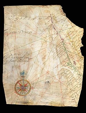
A Dutch East India Company (VOC) manuscript chart fragment of the Arabian Coast and Red Sea signed and dated by Joan Blaeu II Chart fragment in pen, ink, and wash colour on vellum, signed Joan Blaeu II, later profile portrait in charcoal of a lady in early nineteenth century dress to verso, some abrasion to surface of chart. A manuscript chart fragment of the West Coast of Saudi Arabia and the Red Sea, signed and dated by Joan Blaeu II, master chartmaker to the Dutch East India Company, during the Dutch Golden Age. The chart was, at the time, the most accurate depiction of the Arabian and Egyptian coasts of the Red Sea, and is one of only seven extant charts of the area signed by Joan Blaeu II. The chart, drawn on vellum, outlines the coast of the Red Sea from the Gulf of Suez down to the current Saudi Arabian border with Yemen, listing the principal ports and coastal towns, including Jeddah ("Sidade de Judda"). To the sea are marked numerous rocks and shoals, three of which are marked by words in red ink, denoting particular treacherous areas. To the far left is the signature of Joan Blaeu II, the chart's place of production Amsterdam, and the date 1701. Below the signature is a fine compass rose with a fleur-de-lys marking true north, and east marked by a Christian cross, which traditionally denoted the direction of Jerusalem, though, more aptly on this chart, Mecca. A latticework of rhumb lines in red and green ink, typical of sea charts produced in the seventeenth and eighteenth century, and which hark back to the portolans of the sixteenth century, criss-cross the work. The fragment was originally the upper left portion of the: 'Indische Zee gelyckgradighe, van Caep tot de Straet Sunda' [Plane chart of the India Ocean, from the Cape to Sunda Straits], which stretched from the Cape of Good Hope to the Straits of Sunda, the narrow passage of water between the islands of Sumatra and Java. The chart would be carried by all Dutch East India Company ships, on their voyage from Amsterdam to the Dutch port of Batavia, modern day Jakarta. An inspection of the six extant charts with the current example, shows a remarkable consistency in execution, in the placement not only of the geographical information but also in the arrangement of Joan Blaeu II's signature, and the compass rose. One aspect that does change, however, is the omission of the privilege granted by the States General, which appears on his chart of 1688, but is absent on his chart of 1691, our chart of 1701, and a chart dated 1704. Early VOC chart production: In 1602, the Verenigde Oostindische Compagnie (VOC, or Dutch East India Company) was granted a charter by the States General of the Netherlands (the Dutch parliament) to conduct a monopoly in trade east of the Cape of Good Hope and west of the Strait of Magellan. Seventeen years later, in 1619, the Company's monopoly was expanded to include all geographical knowledge (i.e. charts and maps) that had been and would be acquired by the Company. From then on, the dissemination of cartographic information, be it through the publication of charts or rutters, without the express permission of the Company, could lead to a fine of 6000 guilders. This draconian amount suggests not only that the VOC were at pains to keep the latest cartographic knowledge secret, but also that a rather liberal exchange of cartographic knowledge existed before 1619. In order to maintain their hold on the new cartographic information, the Dutch like the Spanish and Portuguese before them, decreed that all charts issued to VOC shipping would be produced by hand (i.e. not printed), and were to be returned to the relevant authorities at the end of each voyage, with substantial penalties for non-compliance. Also, in line with tradition, the charts would be drawn on vellum, a much more robust material than paper, able to withstand the ravages of a long sea voyage. The VOC's first official map and chartmaker was Hessel Gerritsz, who held the position. N° de ref. del artículo 16247
Contactar al vendedor
Denunciar este artículo
![]()

