Descripción
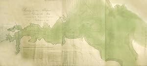
THE FIRST MODERN SCIENTIFIC SURVEY OF THE PATAPSCO RIVER AND CHESAPEAKE BAY Single sheet (88 x 40 4/8 inches, laid down on linen, trimmed with silk). An exceptionally fine, large and beautiful original manuscript map of the Patapsco River from the City of Baltimore to the mouth of the Charles River in Chesapeake Bay, drawn in black and red ink and colour wash, noting all river outlets, points, and depths, with a long explanatory inscription, and inset of "Loading marks." and "Table of Triangulation". Signed by Sherburne, Brantz and Wirgman. Provenance: Probable gift of Mrs Phillip T. Tyson to the Maryland Academy of Sciences in January of 1878; deposited at the Enoch Pratt Free Library, Baltimore from 1937, with their ink stamp and shelfmarks. A beautiful map of the Patapsco River and part of the Chesapeake Bay, principally to give definitive soundings of the river and the bay, which are meticulously recorded, with a red line indicating the "loading marks and ranges used for ships of heavy draft .". These soundings were made by Sherburne, a surveyor with and a Lieutenant in the US navy from about 1813-1827. The survey was conducted by Lewis Brantz, a local merchant, who had travelled extensively and published a memoir of his travels in the western states of America: "He devoted himself, for a long time, to surveying the Patapsco river, its branches, and part of the Chesapeake Bay; the engraved map of which is now found, by expert seamen, to be the best that has hitherto been prepared" (Carnegie Library Pittsbugh). He was instrumental in achieving the building of Maryland's first lighthouse project, recommending that lighthouses be place at the mouth of the Patapsco River at Bodkin Point, North Point and Sparrows' Point. He was president of the Philadelphia and Baltimore Railroad, which he helped to complete in January of 1838, after which he died suddenly. (Monthly Bulletin of the Carnegie Library of Pittsburgh, volume 22, 1917). [WITH:] SHERBURNE, Jonathan W. (fl. 1813-1827), BRANTZ, Lewis (1766-1838), and WIRGMAN, Charles (1781-1821). This Survey of the River Patapsco and part of Chesapeake Bay Instituted by the Marine Insurance Companies of Baltimore and executed at their expense, under the direction of Lewis Brantz, is respectfully dedicated by them to James Monroe. Baltimore: F. Lucas Jr., 1819 (published version of the above). [WITH:] SHERBURNE, Jonathan W. (fl. 1813-1827). Annapolis Harbour & Roads Survey'd by Jonathan W. Sherburne. U.S. Navy. [Baltimore, ca 1817]. [with:] SHERBURNE, Jonathan W. (fl. 1813-1827). Annapolis Harbour & Roads Survey'd by Jonathan W. Sherburne. U.S. Navy. [Baltimore: F. Lucas Jr., 1819]. Single sheet (10 4/8 x 16 inches to the neatline, full margins showing the platemark). Fine detailed and accurate engraved map with original hand-colour wash, an inset from a larger plate, which has been obscured during printing. Single sheet (24 x 37 inches to the neatline, sheet size 25 3/8 x 38 inches, mounted on linen). A fine, detailed and beautiful original manuscript map drawn by John Frederick Geodecke after Sherburne, drawn in pen and black ink with colour wash, showing Annapolis, Fort Madison, and Chesapeake Bay, and decorated with a compass rose, trees, houses, and soundings in the bay, with an inset "Tables of Triangles used in constructing this chart" (one or two chips to edges). Catalogued by Kate Hunter.L63rdffloorhallway and 65E3G. N° de ref. del artículo 72lib122
Contactar al vendedor
Denunciar este artículo
![]()
