
Importe total (1 artículo artículos):
Destino del pedido:

touring book britain (36 resultados)
Ir a los resultados principales
Tipo de artículo
- Todo tipo de artículos
- Libros (35)
- Revistas y publicaciones
- Cómics
- Partituras
- Arte, grabados y pósters
- Fotografías
- Mapas (1)
-
Manuscritos y
coleccionismo de papel
Condición
- Todo
- Nuevos
- Antiguos o usados
Encuadernación
Más atributos
- Primera edición (2)
- Firmado
- Sobrecubierta (1)
- Con imágenes del vendedor (10)
- Sin impresión bajo demanda
Ubicación del vendedor
Valoración de los vendedores
-
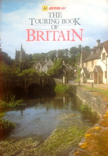
The Touring Book of Britain
Publicado por British Tourist Authority, 1984
ISBN 10: 0861451937ISBN 13: 9780861451937
Librería: Wonder Book, Frederick, MD, Estados Unidos de America
Miembro de asociación: ABAA ILAB
Valoración del vendedor:

Libro
Condición: Good. Good condition. A copy that has been read but remains intact. May contain markings such as bookplates, stamps, limited notes and highlighting, or a few light stains.
Más opciones de compra de otros vendedores en IberLibro
Usado desde EUR 7,52
-

Touring Book of Britain
Publicado por British Tourist Authority, 1984
ISBN 10: 086145202XISBN 13: 9780861452026
Librería: WorldofBooks, Goring-By-Sea, WS, Reino Unido
Valoración del vendedor:
Libro
Hardback. Condición: Very Good. The book has been read, but is in excellent condition. Pages are intact and not marred by notes or highlighting. The spine remains undamaged.
Más opciones de compra de otros vendedores en IberLibro
Usado desde EUR 2,03
Encuentre también Tapa dura Tapa blanda Original o primera edición
-

AA the Touring Book of Britain
Publicado por -, 1991
ISBN 10: 0862839009ISBN 13: 9780862839000
Libro
Hardcover. Condición: Very Good. AA the Touring Book of Britain This book is in very good condition and will be shipped within 24 hours of ordering. The cover may have some limited signs of wear but the pages are clean, intact and the spine remains undamaged. This book has clearly been well maintained and looked after thus far. Money back guarantee if you are not satisfied. See all our books here, order more than 1 book and get discounted shipping.
Más opciones de compra de otros vendedores en IberLibro
Usado desde EUR 4,23
Encuentre también Tapa dura Tapa blanda Original o primera edición
-
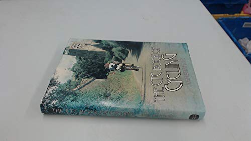
Ctc Book of Cycling: The Cyclists' Touring Club of Britain
Publicado por David & Charles, 1983
ISBN 10: 0715383701ISBN 13: 9780715383704
Librería: Wonder Book, Frederick, MD, Estados Unidos de America
Miembro de asociación: ABAA ILAB
Valoración del vendedor:
Libro
Condición: Very Good. Very Good condition. Very Good dust jacket. A copy that may have a few cosmetic defects. May also contain a few markings such as an owner's name, short gifter's inscription or light stamp.
-

AA, The Touring Book of Britain
Ańo de publicación: 1984
Librería: Library House Internet Sales, Grand Rapids, OH, Estados Unidos de America
Valoración del vendedor:
Hardcover. Condición: Good. No Jacket. Please note the image in this listing is a stock photo and may not match the covers of the actual item. Book.
-
AA THE TOURING BOOK OF BRITAIN
Publicado por BOOK CLUB ASSOCIATES, 1984
Librería: Cambridge Rare Books, Cambridge, GLOUC, Reino Unido
Valoración del vendedor:
Hardcover. Condición: GOOD. 1984. BOOK CLUB ASSOCIATES. . Hardcover. Book: GOOD. 320pp. .
-
AA The Touring Book of Britain
Publicado por Book Club Associates, 1984
Librería: Hay-on-Wye Booksellers, Hay-on-Wye, HEREF, Reino Unido
Valoración del vendedor:

Hardcover. Condición: Very Good. Mild shelf wear with small dents and gentle fading to rear board. Contents clean and appear unread.
-
AA The Touring Book of Britain
Publicado por Book Club Associates
Librería: ThriftBooks-Atlanta, AUSTELL, GA, Estados Unidos de America
Valoración del vendedor:
Hardcover. Condición: Very Good. No Jacket. May have limited writing in cover pages. Pages are unmarked. ~ ThriftBooks: Read More, Spend Less 1.01.
-

Hard Cover. Condición: As New. No Jacket. First Thus. Pictorial laminated board covers quarter-bound with imitation red/gilt leather. 320pp., including numerous colour photographs as well as 30 pages of colour maps. Illustrated endpapers. As new. Price includes allowance for "heavy" postage (well over 1kg.).
-
![Imagen del vendedor de Collection of British Cycling and Touring Books and Maps. 1: J.G. Bartholomew, The Handy Touring Atlas of the British Isles / 2: Alexander Gross and F. Waite-Browne, The Premier Road Book of Great Britain / 3: 'Cycles and Mopeds, Cycling Books of Maintenance / 4: Cycling Touring Club's 'Cycling' [Know the Game Series] / 5: Cyclists' Touring Club, 'C.T.C. Handbook and Guide' / 6: The Kuklos Annual and Handbook for Cyclists and other Roadfarers, 1925 / 7: Harold Briercliffe, Northern England / 8: Harold Briercliffe, Southern England, / 9: Philips New Series of County Maps - Surrey / 10: Bartholomew's Reduced Survey Map of Dorset / 11: Bartholomew's Reduced Survey Map of South Devon / 12: Bartholomew's Reduced Survey Map of York and Scarborough / 13: 'Cycling Map of the Midlands' published by E.J. Larby / 14: Wincarins Motor & Cyclist Map of England (in Sixteen Sections) a la venta por Inanna Rare Books Ltd.](https://pictures.abebooks.com/inventory/md/md30532851381.jpg)
Collection of British Cycling and Touring Books and Maps. 1: J.G. Bartholomew, The Handy Touring Atlas of the British Isles / 2: Alexander Gross and F. Waite-Browne, The Premier Road Book of Great Britain / 3: 'Cycles and Mopeds, Cycling Books of Maintenance / 4: Cycling Touring Club's 'Cycling' [Know the Game Series] / 5: Cyclists' Touring Club, 'C.T.C. Handbook and Guide' / 6: The Kuklos Annual and Handbook for Cyclists and other Roadfarers, 1925 / 7: Harold Briercliffe, Northern England / 8: Harold Briercliffe, Southern England, / 9: Philips New Series of County Maps - Surrey / 10: Bartholomew's Reduced Survey Map of Dorset / 11: Bartholomew's Reduced Survey Map of South Devon / 12: Bartholomew's Reduced Survey Map of York and Scarborough / 13: 'Cycling Map of the Midlands' published by E.J. Larby / 14: Wincarins Motor & Cyclist Map of England (in Sixteen Sections)
Publicado por London, East Ardsley, Wakefield, Yorkshire, Cheltenham, George Newnes / Educational Productions Limited / Temple Press Limited / Daily News Ltd, 1923 - 1952., 1952
Librería: Inanna Rare Books Ltd., Skibbereen, CORK, Irlanda
Valoración del vendedor:
Libro
14 volumes - 8 books, 4 Leporellos and 2 large fold-out maps. 10.5 cm x 15.2 cm - 12.7 cm x 18.5 cm - 20 cm x 13.7 cm - 10.3 cm x 19.5 cm. Circa. 1,100 pages. Numerous colour fold-out maps and in-text maps and tables. Hardcover and softcover. All items in very good condition with a mixture of minor and some stronger signs of wear. Includes, for example, the following: Bartholomew's "Half-Inch to Mile" Survey Maps [folded: 10.3 cm x 19.5 cm - unfolded: 74.5 cm x 62.7 cm], on 32 fold-out panels, coloured and illustrated with topographical information from the Ordinance Survey. scale 1:126,720. Philip's County Map [folded: 10 cm x 15.4 cm - unfolded: 46 cm x 37.5 cm], on 15 fold-out panels, coloured and illustrated with parliamentary electoral boundary information. 'Cycling Map of the Midlands' [folded: 58.8 cm x 44.6 cm - unfolded: ] 18 fold-out panels, coloured and illustrated. Scale 1 inch to 5 miles. Map divided into 10 miles square. Linen-backed. 16 sections of Wincarnis Motor & Cyclist Map of England [folded:12 cm x 17.8 cm - unfolded: 24 cm x 17.8 cm], on 2 fold-out maps, coloured and illustrated. Scale to 10 miles to an Inch. Each individual section represents a geographic regions London, Surrey, Sussex & Kent / Hampshire, Mid Southern Counties / Devonshire, West Somerset, & c / Cornwall & West Devonshire / London, Herts., Essex, S. Suffolk, & c / London & East Midland Counties / Gloucester & West Mid. Counties / South Wales / Norfolk, N. Suffolk, Cambridge, & c / Manchester & N.W. Midland Counties / Mid Wales, Shropshire, & c / Lincolnshire, E. Notts., S.E. Yorkshire / North Wales, Cheshire, & c / Lancashire & West Yorkshire / N.E. Yorkshire & Northumberland / Cumberland, Westmoreland & c etc. Briercliffe's Cycling Touring Guides - Northern England includes, for example: The Lake District / The Yorkshire Dales / The North-East Coast / Shorter Tours and Connecting Routes / Day and Weekedn Tours / Appendix etc. Also included 8 plates and 12 line illustrations taken from drawings by Frank Patterson. Briercliffe's Cycling Touring Guides - Southern England includes, for example: The Thames Valley and the Cotswolds / The Isle of Wight / The New Forest / Between London and the South Coast / The South Coast / Appendix etc. Also included 8 plates and 12 line illustrations taken from drawings by Frank Patterson. Premier Road Book of Great Britain contains route descriptions with gradiated diagrams. Routes include, for example the following routes: LOndon to Croydon and Brighton / Chelmsford to Great Dunmow and Saffron Walden / Wolverhampton to Kidderminster / Machester to Southport / Carnarvon to Barmouth / Oban to Ardrishaig / Index to Routes etc. Also included is map at rear pastedown of "Great Britain by Alexander Gross". 4 discreet St Dunstan's label stamps on reverse. [Know the Game Series] Cycling volume has, for example, information on the following: cycling efficiency / frame design / gear table / general maintenance / road safety etc. Kuklos Annual contains, for example, the following: The Reformed Bicycle / The Woman Cycylist / Tadems / Luggage / Medical Matters / Potted Tours in Great Britain, Ireland, France, Holland / Resthouse Directory, with 4,000 addresses in Britain, Ireland and Northern France etc. The Handy Touring Atlas of the British Isles volume contains, for example, the following: Diagram of Road Altitudes / General Maps / Contoured District Maps - Scale 10 Miles to an Inch / Index to Principal Cycling Centres etc. Cyclists' Touring Club Handbook & Guide 1923, contains, for example, the following: List of Officers / Honorary Life Members / Touring in the British Isles / Moon's Phases / Legal Defence for Members / Railway and Cloak Room Charges for Cycles / Hotel and Farmhouse List Arrangements / Index to Places / Camp Sites / Continental Section etc. Cycling Book of Maintenance includes, for example, the following: frame and steering / the bottom bracket / transmission / hubs / wheels /general maintenace and care of equipment / gera calculation etc. Also, fold-out "blueprint showing the componets of a modern bicycle" at front. Sprache: english.
