
Importe total (1 artículo artículos):
Destino del pedido:

new map circle franconia latest de cary john (2 resultados)
Ir a los resultados principales
Tipo de artículo
- Todo tipo de artículos
- Libros (2)
- Revistas y publicaciones
- Cómics
- Partituras
- Arte, grabados y pósters
- Fotografías
- Mapas
-
Manuscritos y
coleccionismo de papel
Condición
- Todo
- Nuevos
- Antiguos o usados
Encuadernación
- Todo
- Tapa dura
- Tapa blanda
Más atributos
- Primera edición
- Firmado
- Sobrecubierta
- Con imágenes del vendedor
- Sin impresión bajo demanda
Ubicación del vendedor
Valoración de los vendedores
-
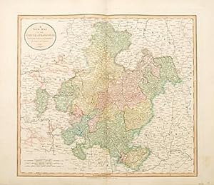
A New Map of the Circle of Franconia. from the latest authorities.
Publicado por London. 1808, 1808
Librería: Peter Harrington. ABA/ ILAB., London, Reino Unido
Miembro de asociación: ABA ILAB PBFA
Valoración del vendedor:

John Cary was a prolific English map seller and engraver, with premises in The Strand in London. He also made globes and scientific instruments. This is his accurate and pleasant map of Franconia. The title is taken from an ancient Germanic tribe; 'The Franks'. Franconia is divided into three specific regions; Lower, Middle and Upper. This map displays the very latest information and discoveries. Published in Cary's 'New Universal Atlas'. Size: 535 x 630 mm. Copperplate engraving in full original wash colour. Fine condition.
-
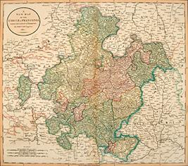
A NEW MAP OF THE CIRCLE OF FRANCONIA, FROM THE LATEST AUTHORITIES.
Publicado por London. 1811, 1811
Librería: Peter Harrington. ABA/ ILAB., London, Reino Unido
Miembro de asociación: ABA ILAB PBFA
Valoración del vendedor:
This beautiful map, accurate and concise, is from John Cary's Universal Atlas. The high standard of design, printing, and geographical accuracy has led many to consider Cary the finest of English map-makers. Copper engraving. Hand coloured. Very good condition, light offsetting and some stains to the margins, not affecting the image. Size: 56 x 49.5 cm.