Importe total (1 artículo artículos):
Destino del pedido:

geografia or cartografia (24 resultados)
Ir a los resultados principales
Tipo de artículo
- Todo tipo de artículos
- Libros (22)
- Revistas y publicaciones
- Cómics
- Partituras
- Arte, grabados y pósters
- Fotografías
- Mapas (2)
-
Manuscritos y
coleccionismo de papel
Condición
Encuadernación
Más atributos
- Primera edición (2)
- Firmado
- Sobrecubierta
- Con imágenes del vendedor (15)
- Sin impresión bajo demanda
Ubicación del vendedor
Valoración de los vendedores
-
![Imagen del vendedor de [Cartografia. Islas Baleares] Paskaart, voor een Gedeelte der Kust van, Barbaria, van C. Ivi, tot Bona. En de Kust van, Catalonia. Eylanden, Yvica, Majorca, en Minorca. a la venta por Llibreria Antiquŕria Delstres](https://pictures.abebooks.com/inventory/md/md31540249199.jpg)
[Cartografia. Islas Baleares] Paskaart, voor een Gedeelte der Kust van, Barbaria, van C. Ivi, tot Bona. En de Kust van, Catalonia. Eylanden, Yvica, Majorca, en Minorca.
Publicado por Johannes van Keulen, [c. 1680]., Amsterdam,, 1680
Librería: Llibreria Antiquŕria Delstres, Canet de Mar, BCN, Espańa
Miembro de asociación: AILA ILAB
Valoración del vendedor:

This is an authentic antique map of the Algerian coast, Balearic Islands and a portion of Spain. The map was published in Amsterdam by the Van Keulen family circa 1680. This lovely sea chart focuses on the Balearic Islands off the coast of Spain with much of the Algerian coastline displayed along the top. The map is presented with a southern orientation with two compass roses pointing to the bottom of the map, indicating north. Numerous depth soundings, anchorages, and hazards are noted throughout. Ports and coastal towns are also indicated, some of which include Barcelona, Mallorca, and Algiers. An insert in the top left focuses on the bay of Algiers. Una gran hoja de papel verjurado con filigrana. Muy buen estado de conservación. 53x61,5 cm.
-
Geografia Istorico-Politica
Publicado por HardPress Publishing, 1688
ISBN 10: 0461358786ISBN 13: 9780461358780
Librería: THE SAINT BOOKSTORE, Southport, Reino Unido
Valoración del vendedor:

Libro
Paperback. Condición: New. New copy - Usually dispatched within 4 working days.
-

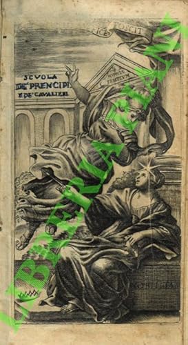
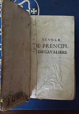
SCUOLA DE' PRENCIPI, E DE' CAVALIERI, CIOE' LA GEOGRAFIA, LA RETTORICA, LA MORALE, L'ECONOMIA, LA POLITICA, LA LOGICA E LA FISICA CAVATE DALL'OPERE FRANCESI
Publicado por casa editrice: PER NICOLO' PEZZANA anno: 1677 citta': VENETIA, 1677
Librería: libreria antiquaria e antichitŕ Onofri, Roma, RM, Italia
Valoración del vendedor:
LEGATURA COEVA CON PIATTI MOLTO BELLI IN PELLE CON IMPRESSO DECORO numero pagine: (14) 552 (40) formato: 14.2X8 stato conservazione: MEDIOCRE, MANCA ANTIPORTA E RISVOLTI. MANCANZE AL DORSO DI COPERTINA, UNA PARTE INTEGRATA CON PELLE LEGGERMENTE PIU' CHIARA. UN PAIO DI MACCHIOLINE traduttore: ABBATE SCIPIONE ALERANI.
-
Scuola de' Principi, e de' Cavalieri, cioč La geografia, la rettorica, la morale, l'economica, la politica, la logica, e la fisica; cavate dall'Opere francesi del sig. Della Motta Le Vayer . Tradotte nella lingua italiana dall'abate Scipione Alerani.
Ańo de publicación: 1684
Librería: Libreria Piani, Monte San Pietro, BO, Italia
Miembro de asociación: ALAI ILAB
Valoración del vendedor:
Venetia, Appresso Niccolň Pezzana, 1684, 16mo (cm. 14,5 x 8) piena pergamena rigida coeva con titoli manoscritti su pecetta cartacea applicata al dorso, pp. (16), 552, (32), con antiporta calcografica (un po' rifilata al taglio). Minime mancanze al taglio del piatto posteriore; titolo dell'antiporta e nome del traduttore sul frontespizio, ricalcate a penna; lievissime, antiche gore, sporadiche fioriture. Buono.
-
Scuola de' principi, e de' cavalieri. cioč: La Geografia, La Rettorica, La Morale, L'Economica, La Politica, La Logica e La Fisica; cauate dall'opere francesi. Del Sig. Della Motta Leuayer tradotte nella lingua italiana da ab. Scipione Alerani
Publicado por Appresso Nicolň Pezzana, Venezia, 1684
pp. (16)-552-(32) 16° In antiporta incisione a piena pag. Indice delle materie contenute. Esemplare fresco ed in ottimo stato cartonato rustico, titolo anticamente manoscritto sul dorso.
-
Scuola de' Prencipi, e de' Cavalieri, cioč la Geografia, la Rettorica, la Morale, l'Economica, la Politica, la Logica, e la Fisica; cavate, e tradotte nella nostra lingua dall'Opere Francesi del Sig. Della Motta Le Vayer.
Publicado por Per Giacomo Monti, In Bologna, 1676
Librería: LIBRERIA ANTIQUARIA PIEMONTESE, TORINO, Italia
Miembro de asociación: ALAI ILAB
Valoración del vendedor:
2 parti in un vol. in-12°, pp. (24), 288, 359; cartonatura antica imitante la pergamena con titolo calligrafato al dorso. Dedica a stampa ad Egidio Colonna, Duca di Anticoli. Fregi tipografici in xilografia. Aloni e bruniture diffuse. Antica firma all'occhietto. Discreto esemplare. Prima edizione in lingua italiana, nella traduzione di Scipione Alerani. "Prima edizione originale di questa traduzione dal francese. Interessante opera di precettistica con notizie e dati curiosi sull' America a pag. 157 e segg. della 1a parte" (Vinciana, n. 2, alla voce "Alerani Scipione"). L'operetta, compendio pedagogico dei principali rami dello scibile, venne composta per l'istruzione del giovane Luigi XIV, di cui l'autore era stato precettore. Il La Mothe Le Vayer (Parigi, 1588-ivi, 1672), fecondo poligrafo, fu uno dei piů eminenti rappresentanti dello spirito scettico nella cultura francese del tempo, soprattutto nei Dialogues faits ŕ l'imitation des anciens par Orasius Tubero (pubblicati con falsa data e falso luogo di stampa fra il 1630 e il 1633) e in De la vertu des paďnes (1642). Accademico di Francia, fu nominato da Anna d'Austria precettore di Filippo d'Orléans, poi del delfino, il futuro Luigi XIV.
-
Scuola de'Principi, e de'Cavalieri, cioe la Geografia, la Rettorica, la Morale, l'Economica, la Politica, la Logica, e la Fisica; cavate dall'Opere Francesi. . per istruzione di Luigi XIV Re' di Francia, tradotte nella lingua Italiana dall'Abate Scipione Alerani.
Publicado por Venetia appresso Niccolo Pezzana, 1684
Librería: Antiquariat Hatry, Heidelberg, Alemania
Miembro de asociación: ILAB VDA
Valoración del vendedor:

12°. Gest. Frontispiz, Titel, 6 Bl., 552 S., 16 Bl. Register. Einfacher Pappband der Zeit, vorderes Gelenk aufgeplatzt, Buchblock gebrochen, Vorsatz mit getilgtem Namenszug, unbeschnitten, innen sauberes Exemplar. "Francois de La Mothe le Vayer (* 1588 in Paris; 9. Mai 1672 ebenda) war ein französischer Antiquar, Philosoph und Moralist. La Mothe le Vayer ist heute weitgehend unbekannt, aber als Zeitgenosse von Rene Descartes und Thomas Hobbes und Angehöriger der damals kleinen akademischen Zirkel von Relevanz. Sein erst zu Lebensende niedergelegter historischer Pyrrhonismus ist eine noch frühe Schrift des Skeptizismus, vereinfacht gesagt, formuliert La Mothe le Vayer, dass es nicht Aufgabe des Historikers sein sollte, jedes Detail der Antike aufzudecken. Moliere verfasste ein Gedicht für ihn aus Anlass des Todes seines Sohnes." (Wikipedia). 300 gr.
-
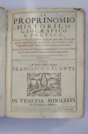
Il proprinomio historico, geografico e poetico in cui per ordine d'alfabeto si pongono quei nomi Propri per qualche singolaritŕ piů memorabili, che nell'Historia, nella Geografia et nelle Favole de' Poeti registrati si ritrovino. E con l'occasione de' Nomi succintamente si racconta tutto ciň, che di notabile ŕ ciascuno d'essi s'appartiene.
Publicado por Per Domenico Miloco,, In Venetia,, 1676
Librería: Studio Bibliografico Benacense, Riva del garda, Italia
Miembro de asociación: ALAI ILAB
Valoración del vendedor:
Cm. 21,5, pp. (8) 480. Marchio tipografico al frontespizio ed un bel finalino alla quarta carta. Legatura coeva in pergamena molle. Un tarletto al margine interno bianco di alcune carte, peraltro buona conservazione. Terza edizione, la prima si stampň nel 1643. Cfr. Piantanida (3756): "Dizionario enciclopedico, ricco di notizie. Non mancano accenni al nuovo mondo (alle voci America, Brasile, Cristoforo Colombo, etc.), alle Indie Orientali, all'Estremo Oriente, etc.".
-
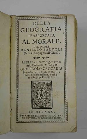
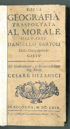
Della geografia trasportata al morale&
Publicado por per Agostino Malatesta,, In Milano,, 1665
Librería: Studio Bibliografico Benacense, Riva del garda, Italia
Miembro de asociación: ALAI ILAB
Valoración del vendedor:
Cm. 15, pp. (36) 476. Stemma gesuitico al frontespizio. Legatura coeva in pergamena. Mancanze e vistose tracce d'uso alla legatura, peraltro esemplare internamente ben conservato. Interessante raccolta di descrizioni geografiche. Segnaliamo almeno quella (di 10 pagine!) riguardante Capri.
-
Scuola de' prencipi, e de' cavalieri, cioč la geografia, le rettorica, la morale, l'economica, la politica, la logica, e la fisica; cavate, e tradotte nella nostra lingua dall'opere francesi del sig. della Motta Le Vayer, che le hŕ distese per instruzion
Publicado por Giacomo Monti, In Bologna, 1676
Libro
Hardcover. Condición: Good. No Jacket. IN ITALIAN RIPPED FIRST PAGE, MISSING PAGE AT FRONTTHAT HAD WRITING ON IT BUT NO PRINTING OR TEXT, SOME UNDERLINING, SOME WRINKLING ON COVER, SOME WRITING ON THE BACK FROM PREV OWNER.
-

Giardino di fiori curiosi in forma di dialogo, diuiso in sei trattati. Nel quale si trattano alcune materie di humanitŕ, filosofia, theologia, geografia. composto per il signor Antonio di Torquemada, & tradotto di spagnuolo in italiano per Celio Malespina
Publicado por appresso Giouanni Alberti, In Venetia, 1620
In-16° (158 x 90 mm.), pp, (30), 1 b., 402, marca tipografica al frontespizio, legatura del secolo successivo in piena pergamena rigida, titolo su tassello e fregi in oro al dorso. l frontespizio piccola mancanza nella parte centrale dovuta presumibilmente per la cancellazione di una firmo con integrazione e nuova firma di appartenenza. Nel complesso buon esemplare fresco. Celio Malesoini. Avventuriero veneziano, vissuto dal 1531 oltre il 1609, che, dopo avere militato nelle Fiandre al servizio degli Spagnoli, condusse in diverse cittŕ d'Italia un'esistenza molto irregolare, ora falsario e truffatore, ora gentiluomo e organizzatore di spettacoli, quando confidente segreto di governi, quando letterato. Ridottosi verso il 1580 nella sua Venezia, pubblicň senza il consenso dell'autore alcuni canti della Gerusalemme liberata; indi tradusse dal francese e dallo spagnolo il Trésor di Brunetto Latini e il Jardín de flores curiosas di Antonio Torquemada. Opera di qualche pregio sono le sue Ducento novelle, composte a Mantova dal 1595 al 1605 per fuggire l'ozio, e pubblicate a Venezia nel 1609.
-
Il Proprinomio historico, geografico, e poetico. In cui per ordine d'Alfabeto si pongono quei nomi Proprii per qualche singolaritŕ piů memorabili, che nell'Historia, nella Geografia et nelle Favole de'Poeti registrati si ritrovino. E con l'occasione de'Nomi succintamente si racconta tutto ciň, che di notabile ŕ ciascuno d'essi s'appartiene. Raccolto con somma diligenza da scritti de' piů Classici, et approvati Auttori. Con nuova aggionta.
Publicado por Venedig Stefano Curti, 1694
Librería: Zentralantiquariat Leipzig GmbH, Leipzig, Alemania
Miembro de asociación: BOEV
Valoración del vendedor:
4 Bl., 416 S. m. 1 Druckermarke (Markuslöwe), 1 Schlußvignette u. 1 Porträt (des Grammatikers Lucio Giovanni Scoppa). Neuer Ppbd (alter Besitzvermerk a. Titel, streckenweise etwas braunfleckig, Seitenrand knapp beschnitten, wenige Bl. m. min. Buchstabenverlust, einige alte Marginalien). Erweiterte Auflage der ersten Ausgabe von 1643.- Der aus Cremona stammende Barezzo Barezzi lebte als Buchdrucker in Venedig. Sprache: Italienisch.
-
Giuoco d'arme dei sovrani, e degli stati d'Europa. Per apprender l'arme, la geografia, e la storia loro curiosa. Di C. Oronce Fine, detto di Brianville. Tradotto dal francese . da Bernardo Giustiniani veneto
Publicado por Giacomo Raillard, Napoli, 1692
Librería: Libreria Antonio Pettini, ROMA, RM, Italia
Miembro de asociación: ALAI ILAB
Valoración del vendedor:
In-16°, 12cc, 285pp, una carta ripiegata, mancante delle carte da gioco. Stemma alla carta a1v.Legatura in piena pergamena rigida, con titolo manoscritto al dorso.
-
Geografia cioč Descrittione universale della terra partita in due volumi, nel primo de' quali si contengono gli otto libri della Geografia di Cl. Tolomeo, nuovamente con singolare studio rincontrati et corretti dall'eccell.mo sig. Gio. Antonio Magini padovano. Nel secondo vi sono poste XXVII. tavole antiche di Tolomeo, et XXXVII. altre moderne, tutte reviste, et in alcuni luoghi accresciute, et illustrate da ricchissimi commentarij di detto sig. Magini. Opera utilissima and specialmente necessaria allo studio dell'historie, dal latino nell'italiano tradotta dal R.D. Leonardo Cernoti vinitiano. Con due indici copiosissimi, nuovamnte corretto et accresiutto.
Publicado por Appresso Paolo et Francesco Galignani fratelli., Padova, 1621
Softcover. Condición: Befriedigend. Erster Teil ist von 1621 , der zweiter von 1620. 2 Bl. (neu)+ 1 Titelblatt, 1. unnum. Blatt+ 62 S.+ 21 S, (Maginis Bermerkungen) . +1 weißes Blatt+ 14 unnum. Bl. (tavola) und Titelbatt+ 1, Bl.+ 21-212 S. + 30 Bl. (tavola). Quarto. Flexibler Pergamenteinband der Zeit mit Titel am Rücken (leicht fleckig, aber insgesamt gut). Feste Buchbindung. Stempel auf dem Titelblsatt. Teilweise stockfleckig, aber sauber ohne Anstreichungen. Feste Buchbindung. Fehlen die 54 gestochen Tafeln sowie die S. 1-20 des zweiten Bandes. Vielleicht wurde das Buch ohne sie gebunden-. Die Vorsatzblätter wurden erneuert. Bibliotheksstempel auf den Vorsatzblättern. Sonst ohne Anstreichungen. Abgesehen von diesen Mängel ist das Buch relativ gut erhalten. ALL THE MAPS AND PP. 1-21 OF THE SECOND VOLUME ARE MISSING Bei dieser Ausgabe handelt es sich um die zweite Auflage von Cernotis Übersetzung von der Magini-Ausgabe des Ptolomäeus Vgl. Sabin 66508.; Phillips, A List of the geograhical atlasses in the Library of Congress, 436. Buch.
-
Hardcover. Condición: Good. All Illustrissimo, e reverendissimo Sig. Abate Cesare Mezamici. In Bologna 1669. Apud G. recatuini. (14,5 x 8 cm), k. [15], s. 603, [1], opr. psk. z epoki (?). Ślady niew. zawilg. Stan dobry. Daniello Bartoli (1608-1685), włoski jezuita, teolog, uczony, historyk.
-
Della Geografia Trasportata Al Morale. All . (Monsignore) Gio. Paolo Zaccaria (etc.)
Publicado por Milano, A. Malatesta 1665., 1665
Librería: Antiquariat Löcker, Wien, Austria
Miembro de asociación: GIAQ ILAB VDA VDAO
Valoración del vendedor:
BN VIII,324. Vgl. DeBacker-S. I,975 (Ausg. Milano 1664). Diz. Encycl. d. lett. ital. I,274. BBKL 1,399 - B. (1608-1685), gilt als e. d. fruchtbarsten und auch literarisch bedeutsamsten jesuitischen Schriftsteller, e. Klassiker d. italienischen Prosa, der "si espresse in uno stilo fastoso e ridondante definito . `magnifico`". Unter seinen zahlreichen Werken fanden seine geschichtlichen und biographischen Arbeiten besondere Beachtung. 12°. Vort., Titelbl., 16 nn. Bll., 476 S., mit e. Zierrahmen u. e. Vignette am Titelblatt, sowie Kopfleisten, Vignetten, Initialen u. Schlußvignetten. Biegsamer Pappband d. Zeit, mit verblasster alter Rückenbeschriftung, Einband in gutem Zustand, geringer Wurmfraß im hinteren Vorsatz. Buchblock knapp u. etwas schief beschnitten, vermutlich wegen fehlerhafter Bogenfaltung Textverlust auf S. 159. Mit e. alten handschriftlichen Jahreszahl (1665) am Vortitel, Buchstaben von alter Hand am vorderen Spiegel u. e. alten Beschriftung am unteren Schnitt.
-
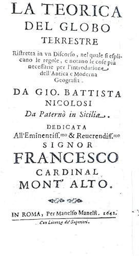
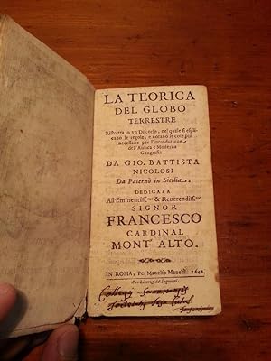
La teorica del globo terrestre et esplicatione della carte da navigare. Ristrette in un discorso, nel quale si esplicano le regole, e notano le cose piů necessarie per l'introduzione dell'antica e moderna geografia.In Roma, per Manelfo Manelfi, 1642.
Publicado por In Roma, per Manelfo Manelfi, In Roma, 1642
Librería: Studio Bibliografico Apuleio, Trento, Italia
Miembro de asociación: ALAI ILAB
Valoración del vendedor:
Condición: Buono (Good). 0. Cm. 14, pp. (24) 235 + (5) di tabelle di dati relativi al globo terrestre. Antiporta calcografica con raffigurazione del globo terrestre con le armi araldiche del cardinale Francesco Montalto cui l'opera è dedicata. Bella legatura strettamente coeva in piena pergamena mollecon titoli manoscritti al dorso. Antico rinforzo alla parte bassa del retro dell'antiporta. Trascurabili e marginali forellini all'angolo inferiore bianco. Esemplare fresco e ben conservato. Rara e ricercata prima edizione di importante trattato geografico-astronomico di Giovanni Battista Nicolosi (1610 - 1670), sacerdote e funzionario della Curia Vaticana originario di Paternò in Sicilia. Nicolosi, pur dichiarando di essere obbediente alla Chiesa fino al patibolo, fu autore di numerosi saggi scientifici improntati chiaramente alla teoria tolemaica. Quest'opera segnalò ben presto Nicolosi all'attenzione degli ambienti scientifici e gli valse, forse anche per intervento del cardinale Francesco Peretti di Montalto (dedicatario della stessa), l'incarico dell'insegnamento della geografia presso l'Ateneo romano. Nicolosi, che ebbe grande ammirazione per Galileo Galilei da lui definito â filosofo principe e faro di filosofiaâ , deplorò l'abiura a cui era stato costretto. Cfr. Iccu, Piantanida, 1352: â Rara edizione originale ed unicaâ ; Riccardi, Biblioteca, matematica italiana, I, col. 198. . . . . . . 0. . Book.
-
TEORICA DEL GLOBO TERRESTRE RISTRETTA IN UN DISCORSO, NEL QUALE SI ESPLICANO LE REGOLE E NOTANO LE COSE PIU' NECESSARIE PER L'INTRODUTIONE DELL'ANTICA E MODERNA GEOGRAFIA (LA)
Publicado por Manelfo Manelfi, Roma, 1642
Librería: Libreria Scripta Manent, ALBENGA, SV, Italia
Valoración del vendedor:
Edizione: Prima edizione . Pagine: 240 . Illustrazioni: Incisione all'antiporta e tavole . Formato: 24° . Rilegatura: Pergamena con dorso scritto in gotico a mano . Stato: Buono . Caratteristiche: L'opera č dedicata all'Eminentissimo e Reverendissimo Francesco Cardinal Mont'Alto. Bruniture. Piccoli segni di tarlo alle ultime pagine.Timbri di appartenenza. Nicolosi originario di Paternň, fu sacerdote e funzionario della Curia Vaticana. Scrittore e geografo aderě alla teoria tolemaica, dichiarando di essere obbediente alla Chisa fino al patibolo. Ammirava Galileo definendolo filoso principe e faro di filosofia, deplorando l'abiura a cui era stato costretto.Foto disponibili .
-
La Descrittione della campagna di Roma, detta dagli antichi Latium, Regione appresso tutte le nationi, et intutti i tempi famosissima, per la grandezza dell' imperio suo: laquale é messa in disegno secondo, che hoggi si truova, contutte le sue Terre, Castella, Ville, Fiumi, Monti, et Selve, et hora data alle stampe, ŕ commune utilitŕ de' studiosi della Geografia. Roma L'Anno .M.D. LXIII. Ioannes Orlandi formis rom[a]e 1602. Claudij Duchetti formis
Publicado por Giovanni Orlandi, Rome, 1602
Librería: Arader Books, New York, NY, Estados Unidos de America
Valoración del vendedor:
Mapa Original o primera edición
No binding. Condición: Very good. First. First edition, third state. Rome: Giovanni Orlandi, 1602. Single-sheet engraved map (sheet: 16 3/8" x 21 7/8", 415mm x 556mm; neat-line: 313mm x 464mm). Sometime folded vertically, with a paper mount verso and attendant tanning from the adhesive. Some chips to the upper edge of the sheet, and some marginal soiling. "39" in ink manuscript in an old hand at the upper-right corner recto, "38" in ink manuscript struck through and renumbered at the upper-right corner verso.Wide margins. Presented in an acetate sleeve. Antonio Lafreri (1512-1577) was a Burgundian cartographer-publisher who settled in Rome ca. 1540. He produced -- that is, both engraved and caused to be engraved -- and sold maps and atlases in the third quarter of the XVIc that are among the most celebrated Italian cartographic achievements. The so-called "Lafreri school" of mapmaking is a loose agglomeration of named and anonymous mapmakers. Claudio Duchetti (d. 1585) was Lafreri's nephew, and Giovanni Orlandi likely inherited a great many of those plates, printing many of them in 1602 (as in the present example); "formis" is Latin for "by the templates of," here referring to the copper plates. Because Bifolco-Ronca identifies the first state of the map without the name of Duchetti, the mapmaker is strictly anonymous. The view of Lazio (the "knee" of Italy, surrounding Rome) is ultimately derived from a 1547 map of Eufrosino della Volpaia; various mapmakers including Gastaldi, Forlani, Bertelli and Camocio made versions of the map. It shows a Rome still very much smaller than today's sprawl, with its ancient monuments -- Colosseum, Pantheon, Trajan's Column -- depicted as icons of the eternal city. Bifolco-Ronca record only three examples of the map in institutional collections: the Bertarelli in Milan, the Bibliothčque nationale de France and Stanford University. Acquired at Swann 7 December 2023, lot 152. Bifolco-Ronca III.1027 (pp. 2034-2035), stato 3°.
-
Geografia cioč Descrittione Universale della Terra Partita in due volumni, Nel Primo de' quali si contengono gli Otto Libri della Geographia di Cl. Tolomeo.
Publicado por Paolo & Francesco Galignani, 1621
Libro
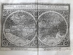
Hardcover. Condición: Very Good. Ptolemaeus Claudius, Geografia 1620-1621. -2 parts in 1 volume in Quarto -300x220mm -[1], 6, [1], 62 [i.e. 63], 21, [14]; 212, [30] -One Folding chart and 63 half page maps (27 ancient and 36 modern) -Complete -Contemporary limp vellum -Generally good condition. Some loosening of binding. Some old wormholes to pages Early illustrated edition of Ptolemy with ancient and modern maps engraved by Girolamo Porro. Includes a Double-hemisphere world map "Orbis Terrae Compendiosa Descriptio" which is a reduction of Rumold Mercator's world map.
-
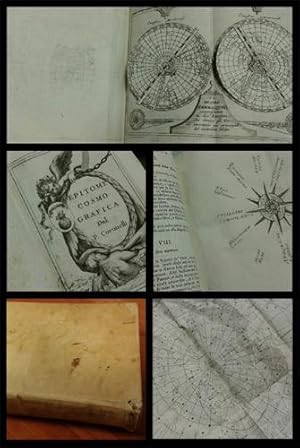
Epitome cosmografica, o compendiosa introduttione all'astronomia, geografia, & idrografia, per l'uso, dilucidatione, e fabbrica delle sfere, globi, planisferj, astrolabj e Tavole geografiche e particolarmente degli stampati, e spiegati nelle publiche lettioni dal p. maestro Vincenzo Coronelli M.C. cosmografo della Serenissima Republica di Venetia, e lettore di geografia . per l'Accademia . degli Argonauti. Antiporta allegorica, tabelle nel testo e 36 tavole incise in rame fuori testo di cui 30 a doppia pagina, una con due volvelle mobili e 6 piů volte ripiegate, pergamena moderna, dorso iscritto. Leggere fioriture su alcune carte.
Publicado por ad istanza di Andrea Poletti, Colonia \i.e. Venezia], 1693
Original o primera edición
Condición: BUONO. cm.18,2x12,3, pp.30], 420, 36 su 38 tavole cartografiche splendide, pergamena coeva. Iniziali e fregi xilografici, stemma dell'Accademia degli Argonauti sul frontespizio. Mancante della parte inferiore del frontespizio. NOTA:Esemplare molto buono ad eccezione delle mancanze segnalate / Colonia \i.e. Venezia] ad istanza di Andrea Poletti cm.18,2x12,3, pp.30], 420, 36 su 38 tavole cartografiche splendide, anche piů volte ripiegate, esemplare mancante di due tavole a pp.256 e 264. Legatura in piena pergamena coeva. Iniziali e fregi xilografici, stemma dell'Accademia degli Argonauti sul frontespizio. Mancante della parte inferiore del frontespizio. Prima edizione. anche piů volte ripiegate, esemplare mancante di due tavole a pp.256 e 264. Legatura in piena.
-
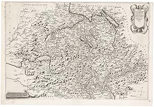
Nuova Geografia Delli Statide XIII. Cantoni de SS.ri Suizzeri, Grigioni, Valesani, et de Princepi con, essi Confinanti 1637.
Ańo de publicación: 1637
Librería: Altea Antique Maps, London, Reino Unido
Miembro de asociación: ABA ILAB PBFA
Valoración del vendedor:
Mapa
Italian, 1637. 355 x 525mm. A few small repairs, trimmed close to plate mark at top. A very scarce map of Switzerland, with Savoy and the lakes of Northern Italy, decorated with ornate cartouches for the title and scale. It is not listed in any of the bibliographies of maps of Switzerland or any known collections.
-
Geografia Cioe Descrittione Universale Della Terra. Partita in due volumi, Nel primo de? quali si contengono gli Otto Libri della Geografia Di Cl. Tolomeo?
Publicado por Paolo, & Francesco Galignani., Padova, 1621
Librería: Alexandre Antique Prints, Maps & Books, Toronto, ON, Canada
Miembro de asociación: ABAC ILAB
Valoración del vendedor:
Edition : Second Italian edition. , Recent full calf boards. Matching upper and lower with double blind panels, gilt floral devices at corners of inner panel. Spine with 4 raised bands, abbreviated title in gilt on maroon label in 2, remaining compartments with gilt devices and blind rules. , Translated from Latin into Italian by Leonardo Cernoti Vinitiano.Text in Italian. A fine example of this monumental atlas and treatise on cartography, considered to be the most influential cartographic and geographical account of the ancient world, originally written by Ptolemy in Greek around 150 AD. Claudius Ptolemy (c.100 ? c.170 AD) was a mathematician, astronomer, astrologer, and geographer living in the city of Alexandria (then the Roman province of Egypt under Roman rule) who wrote a number of scientific treatises that greatly influenced Byzantine, Islamic, and Western European science. His Geografia, written around 150 AD, is a thorough discussion on maps and the geographic knowledge of the Greco-Roman world and also serves as a handbook on how to draw maps using geographic coordinates for parts of the Roman world known at the time. Geografia draws from an earlier work by Marinus of Tyre, now lost to us, as well as various Roman and Persian gazetteers.Geografia is divided into 8 books: book I is a treatise on cartography, describing the methods used to assemble and arrange Ptolemy's data; from Book II through the beginning of Book VII, a gazetteer provides longitude and latitude values for the world known to the ancient Romans; the rest of book VII provides details on three projections to be used for the construction of a map of the world, varying in complexity and fidelity; book VIII constitutes an atlas of regional maps. The maps include a recapitulation of some of the values given earlier in the work, which were intended to be used as captions to clarify the map's contents and maintain their accuracy during copying. Geografia was translated into Arabic in the 9th century and Latin around 1406 and was a highly influential resource on the cartographic traditions of the medieval Caliphate and Renaissance Europe., Size : Small Folio (301x 206 mm), Complete with 64 engraved maps (27 Ptolemaic, 37 modern), including the rare double-page world map ?Orbis Terrae Compendiosa Descriptio? engraved by Girolamo Porro, in addition to 14 in-text illustrations, plus title vignette and chapter headpieces. Folio pagination. La Seconda Parte Della Geografia di Cl. Tolomeo?: title dated 1620; period marginalia in margins of 126v; 154 mispag. 174. Pg. 13 of Commentarii, et Annotationi? unnumbered. , Volume : 2 parts in 1 volume. , References : Sabin 66506; Phillips, Atlases, 405; Adams M-118; Shirley 193-96, Blank (2). Title. 1597 dedication to Marco Cornaro from Gio. Battista & Giorgio Galignani. 1621 dedication to Marco Cornaro from Paolo & Francesco Galignani. Blank. [Della Geografia di Claudio Tolomeo]: p. 1-62. [Commentarii, et Annotationi dell?Eccell. Sig. Gio. Antonio Magini Padouano?]: p. 1-21. Blank (2). Table of contents. Index (27). [La Seconda Parte Della Geografia di Cl. Tolomeo?]: p. 2-212. Blank. Index (59). Blank (3). Some toning, interior otherwise clean and crisp.
-
Geografia cioe` Descrittione Universale della terra partita in due volumi . XXVII. Tauole Antiche di Tolomeo, e XXXVII. altre Moderne, tutte reuiste, & in alcuni luoghi accresciute, & illustrate da ricchissimi Commentar? di detto Sig. Magini
Publicado por 1621-1620., 1621
Librería: Maggs Bros. Ltd ABA, ILAB, PBFA, BA, London, Reino Unido
Miembro de asociación: ABA ILAB PBFA
Valoración del vendedor:
Quarto (298 x 200 mm); two parts in one volume, twenty-seven Ptolemaic maps and thirty-seven modern maps; the first part the Geographia, the second Magini?s commentary and additions. The second dedication is misbound. Contemporary vellum, five raised bands and ms. title to head of spine. Vellum covering raised bands worn and in some places cracked with minor loss. Padua : Paolo and Francesco Galignani, Uncommon edition of Ptolemy?s Geografia, as published by Magini in 1596, subsequently edited by Leonard Cernoti, here reprinted in 1621. Giovanni Antonio Magini (1555-1617) was the leading mapmaker of his day working in Italy, author of the first printed atlas devoted to Italy, and also a very important (and rare) wall-map of Italy. Because of the rarity of these works, he is perhaps best known for this edition of Ptolemy, which met both with critical and commercial success, and was reprinted to 1621. Magini?s edition is significant for the greatly expanded commentary to the maps that he added. The maps were engraved by Girolamo Porro (1529-1600), the most famous of the Italian map engravers of the period, best known for the island maps in Tomaso Porcacchi?s Isole piu famose del Mondo, 1572, although his work is found in many illustrated books of the period. Porro was praised for the delicacy of his work, despite the handicap of poor vision in one eye. The map of Forum Julii is notable for containing a compass on which is shown magnetic variation. This edition is larger format than usual, as it has the maps printed above text, which continues on the verso. References: Shirley, T.PTOL-12c; Nordenskiold Collection Catalogue, II, 233.

![Imagen del vendedor de La Descrittione della campagna di Roma, detta dagli antichi Latium, Regione appresso tutte le nationi, et intutti i tempi famosissima, per la grandezza dell' imperio suo: laquale é messa in disegno secondo, che hoggi si truova, contutte le sue Terre, Castella, Ville, Fiumi, Monti, et Selve, et hora data alle stampe, ŕ commune utilitŕ de' studiosi della Geografia. Roma L'Anno .M.D. LXIII. Ioannes Orlandi formis rom[a]e 1602. Claudij Duchetti formis a la venta por Arader Books](https://pictures.abebooks.com/inventory/md/md31754863625.jpg)