Importe total (1 artículo artículos):
Destino del pedido:

duche savoye comprend chablais fossigny de vaugondy robert didier (6 resultados)
Ir a los resultados principales
Tipo de artículo
- Todo tipo de artículos
- Libros
- Revistas y publicaciones
- Cómics
- Partituras
- Arte, grabados y pósters
- Fotografías
- Mapas (6)
-
Manuscritos y
coleccionismo de papel
Condición
- Todo
- Nuevos
- Antiguos o usados
Encuadernación
- Todo
- Tapa dura
- Tapa blanda
Más atributos
- Primera edición
- Firmado
- Sobrecubierta
- Con imágenes del vendedor
- Sin impresión bajo demanda
Ubicación del vendedor
Valoración de los vendedores
-
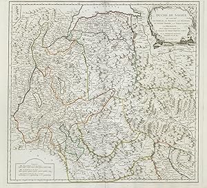
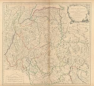
Duche de Savoie qui comprend le Chablais, le Fossigny, le Genevois, la Savoye Propre, la Tarentaise et la Maurienne dressé d'apres la Grande Carte de Piemon de Tomaso Borgomo et andres." - Savoia Savoie Savoyen Aosta Karte map carta incisione gravure
Publicado por Paris, 1751
Librería: Antiquariat Steffen Völkel GmbH, Seubersdorf, Alemania
Miembro de asociación: ILAB VDA
Valoración del vendedor:

Mapa
Großformatige handkolorierte originalKupferstich-Kartevon 1751. - Blattmasse: ca. 51 x 67 cm. -- gut erhalten. || Large handcolored original engraved map from 1751. -- in good condition. || Dies ist ein Original! - Kein Nachdruck! - Keine Kopie! -- This is an original! No copy! - No reprint! Sprache: Französisch Gewicht in Gramm: 1550.
-
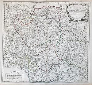
Duche de Savoie qui comprend le Chablais, le Fossigny, le Genevois, la Savoye Propre, la Tarentaise et la Maurienne dressé d'apres la Grande Carte de Piemon de Tomaso Borgomo et andres." - Savoia Savoie Savoyen Aosta Karte map carta incisione gravure
Publicado por Paris ca. 1750., 1750
Librería: Antiquariat Steffen Völkel GmbH, Seubersdorf, Alemania
Miembro de asociación: ILAB VDA
Valoración del vendedor:
Mapa
Altkolorierte Kupferstich-Kartevon ca. 1750 - Blattmasse: ca. 51 x 67 cm -- im Mittelbug leicht gebräunt, sonst gut erhalten. || Old colored engraved map from ca. 1750 - slightly browned on the centerfold, otherwise in good condition. Sprache: Französisch Gewicht in Gramm: 35.
-
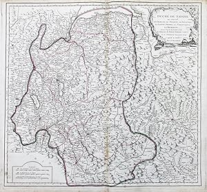
Duché de Savoye qui comprend le Chablais, le Fossigny, le Genevois, la Savoye Propre, La Tarentaise et la Maurienne" - Savoia Savoie Savoy Geneva Annecy Chambery Cluses Aosta Martigny Moutiers Lac Leman carte gravure
Publicado por Venezia, Santini & Remondini, 1778
Librería: Antiquariat Steffen Völkel GmbH, Seubersdorf, Alemania
Miembro de asociación: ILAB VDA
Valoración del vendedor:
Mapa
Großformatige altkolorierte Kupferstich-Karte von 1778. -- Blatt-Maße: ca. 52 x 74 cm. -- sehr gut erhalten. || Large old colored engraved map from 1778. -- in very good condition. || Francesco Santini was a Venetian publisher. He acquired the printing plates of Vaugondy's Atlas Universel, a commercial and cartographic success, with widespread influence on mapmakers throughout Europe. Together with his brother Paolo, he commissioned a new set of plates and reissued the atlas in 1776. In the following years, Paolo Santini assigned all his publication rights to M. Remondini, who in 1777 reissued the same atlas, but with his name. || Dies ist ein Original! - Kein Nachdruck! - Keine Kopie! -- This is an original! - No copy! - No reprint! Sprache: Französisch Gewicht in Gramm: 550.
-
Duché de Savoye qui comprend le Chablais, le Fossigny, le Génevois, la Savoye Propre, la Tarentaise et la Maurienne; dressé d'aprčs la Grande Carte de Piemont de Tomaso Borgomo et autres, par le Sr. Robert de Vaugondy, Geographe ord? du Roy. Avec Privilege
Ańo de publicación: 1751
Mapa
Condición: Good. "Duché de Savoye " Duchy of Savoie. French Alps. Aosta. VAUGONDY 1751 old map. Large antique 18th century atlas map, printed on thick, good quality paper with original outline hand colour/color and decorative title cartouche; Robert de Vaugondy, Gilles & Didier (1751). 49.5 x 54.5cm, 19.5 x 21.5 inches; this is a folding map. Condition: Good. Please contact us if you would like to arrange to view this map. There is nothing printed on the reverse side, which is plain.".
-
Duché de Savoye qui comprend le Chablais, le Fossigny, le Génevois, la Savoye Propre, la Tarentaise et la Maurienne; dressé d'aprčs la Grande Carte de Piemont de Tomaso Borgomo et autres, par le Sr. Robert de Vaugondy, Geographe ord? du Roy. Avec Privilege
Ańo de publicación: 1751
Mapa
Condición: Good. "Duché de Savoye " Duchy of Savoie. Aosta & French Alps. VAUGONDY 1751 old map. Large antique 18th century atlas map, printed on thick, good quality paper with original outline hand colour/color and decorative title cartouche; Robert de Vaugondy, Gilles & Didier (1751). 50.0 x 55.0cm, 19.75 x 21.5 inches; this is a folding map. Condition: Good. Please contact us if you would like to arrange to view this map. There is nothing printed on the reverse side, which is plain.".
-
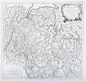
Duche de Savoye qui comprend Le Chablais, le Fossigny, le Genevois, la Savoye Propre, la Tareentaise et la Maurienne
Publicado por Paris, 1760
Librería: Alexandre Antique Prints, Maps & Books, Toronto, ON, Canada
Miembro de asociación: ABAC ILAB
Valoración del vendedor:

Mapa
Condición: Excellent. Size : 502x540 (mm), 19.75x21.25 (Inches), Original Outline Coloring.