
Importe total (1 artículo artículos):
Destino del pedido:

carte plate lile necker de pérouse jean francois galaup (3 resultados)
Ha buscado:
Autor :
pérouse jean francois galaup
,
Título :
carte plate lile necker
Modificar la búsqueda
Ir a los resultados principales
Tipo de artículo
- Todo tipo de artículos
- Libros (1)
- Revistas y publicaciones
- Cómics
- Partituras
- Arte, grabados y pósters (2)
- Fotografías
- Mapas
-
Manuscritos y
coleccionismo de papel
Condición
- Todo
- Nuevos
- Antiguos o usados
Encuadernación
- Todo
- Tapa dura
- Tapa blanda
Más atributos
- Primera edición
- Firmado
- Sobrecubierta
- Con imágenes del vendedor
- Sin impresión bajo demanda
Ubicación del vendedor
Valoración de los vendedores
-

Carte Plate de l'Ile Necker situee par 23.34.' de Latitude N, et 166.52' de Longitude a l'Ouest de Paris et de la Basse des Fregates Francaises situee par 23.45. de Latitudine N. et 168. 10.' de Longitude, decouvertes en Novembre 1786." - Necker Island Hawaii Hawaiian Islands French Frigate Shoals Atlas du Voyage de la Perouse
Publicado por Paris, 1797
Librería: Antiquariat Steffen Völkel GmbH, Seubersdorf, Alemania
Miembro de asociación: ILAB VDA
Valoración del vendedor:

Arte / Grabado / Póster
Großformatiger original Kupferstich. -- -- Blattmaße: ca. 80 x 57 cm. -- im oberen Außenrand etwas braunfleckig, sonst gut erhalten. || Large format original copper engraving. -- -- slightly brownstained on the upper margin, otherwise in good condition. -------------------------------------------------------------------------------------------------------- Jean-François de Galaup de La Pérouse (1741 1788) war ein französischer Seefahrer, Weltumsegler und Geograf im Zeitalter der Aufklärung. Von 1772 bis 1776 segelte La Pérouse im Auftrag des französischen Gouverneurs im Indischen Ozean zwischen den französisch beherrschten Kolonien Mauritius, Réunion, Pondicherry in Südindien und Madagaskar und später auch nach Australien. Im Februar 1788 schickte La Pérouse eine Nachricht mit der weiter geplanten Route in die Heimat: über Tonga, Neukaledonien und die Salomonen sollte es nach Neuguinea gehen. Doch La Pérouse erreichte keines dieser Ziele. Beide Schiffe nebst Mannschaft verschwanden spurlos. Man nimmt an, dass die Schiffe in einen tropischen Wirbelsturm gerieten. ------------------------------------------------------------- ------------------------------------------- Jean-François de Galaup de La Pérouse (1741-1788) was a French navigator, circumnavigator and geographer in the Age of Enlightenment. From 1772 to 1776, La Pérouse sailed on behalf of the French governor in the Indian Ocean between the French-controlled colonies of Mauritius, Reunion, Pondicherry in southern India and Madagascar and later also to Australia. In February 1788, La Pérouse sent a message with the further planned route home: via Tonga, New Caledonia and the Solomon Islands it was to go to New Guinea. But La Pérouse did not achieve any of these goals. Both ships and crew disappeared without a trace. The ships are believed to have been hit by a tropical cyclone. This engraving comes from the very rare Atlas Atlas du Voyage de la Perouse." printed in Paris in 1797. Sprache: Französisch Gewicht in Gramm: 1550.
-

Carte Plate de L'Île Necker. Plan et Vues de L'Île Necker
Publicado por Paris, 1797
Arte / Grabado / Póster
Condición: ACEPTABLE. Mapa Plano de la Isla Necker. Plano y Vistas de la Isla Necker. Mapa grabado número 38 del Atlas du Voyage de la Pérouse / Atlas de Viajes de La Pérouse. Se presentan las Islas de Sable y la Isla Necker con sus diferentes vistas desde alta mar, además de la ruta marítima entre ellas. (Otro ejemplar en Blanco y Negro). Formato (cm): 49x68.
-
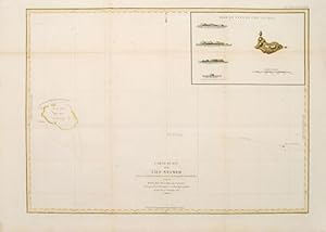
Carte plate de l'Ile Necker.
Publicado por Paris: 1797, 1797
Librería: Peter Harrington. ABA/ ILAB., London, Reino Unido
Miembro de asociación: ABA ILAB PBFA
Valoración del vendedor:
From the Voyages of La Pérouse who set sail from France in 1785 to continue the discoveries of Captain Cook. He was shipwrecked in 1788 but his narrative, maps, and views survived and were published in 1797. Sea chart showing Necker Island, a small island in the Pacific Ocean, part of the Nortwestern Hawaiian Islands. La Perouse was the first European to visit the island, in 1786. Map inset in the right top corner showing profiles of the island from different angles. Atlas Du Voyage De La Pérouse. Size: 680 x 485 mm. Copper engraving. Hand coloured. Very good condition. Faint waterstain to the left vertical fold. Good margins. Watermarks. Folds as issued.