
Importe total (1 artículo artículos):
Destino del pedido:

cairo nile delta (43 resultados)
Ir a los resultados principales
Tipo de artículo
- Todo tipo de artículos
- Libros (32)
- Revistas y publicaciones
- Cómics
- Partituras
- Arte, grabados y pósters (1)
- Fotografías
- Mapas (6)
-
Manuscritos y
coleccionismo de papel (4)
Condición
Encuadernación
Más atributos
- Primera edición (2)
- Firmado
- Sobrecubierta (3)
- Con imágenes del vendedor (18)
- Sin impresión bajo demanda
Gastos de envío gratis
Ubicación del vendedor
Valoración de los vendedores
-
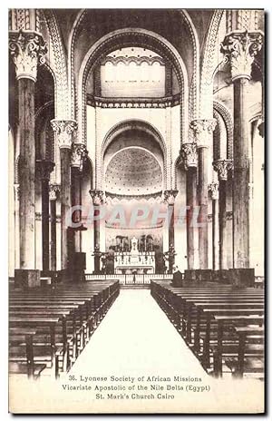
Carte Postale Ancienne Missions Vicariate Apostolic of the Nîle Delta St Marks's church Cairo Egypte
Manuscrito
Carte Postale Ancienne Missions Vicariate Apostolic of the Nîle Delta St Marks's church Cairo Egypte.
-
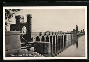
Ansichtskarte Cairo, Nile Delta Barrage
Manuscrito
Condición: Gebrauchsspuren. ***Ansichtskarte Cairo, Nile Delta Barrage*** ungelaufen, rückseitig Klebe- und Papierreste, guter Zustand | Preis: 6.00 EUR | Keine MwSt.-Ausweisung, differenzbesteuert gem.§25a UStG | Versandkosten: Kostenloser Versand | Ausland > Afrika > Ägypten > Stadt Cairo.
-
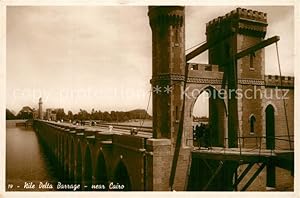
Carte Postale Moderne Cairo Nîle Delta Barrage.
-
Postkarte Carte Postale 73529974 Cairo Egypt Nile Delta Barrage Cairo Egypt
Librería: Versandhandel Boeger, Weil am Rhein, Alemania
Valoración del vendedor:

Manuscrito
Nile Delta Barrage 1939 postalisch nicht gelaufen.
-

Footprint Focus Cairo & Nile Delta (Footprint Focus Egypt: Cairo & Nile Delta)
Publicado por Footprint, 2012
ISBN 10: 1908206691ISBN 13: 9781908206695
Libro
Gut/Very good: Buch bzw. Schutzumschlag mit wenigen Gebrauchsspuren an Einband, Schutzumschlag oder Seiten. / Describes a book or dust jacket that does show some signs of wear on either the binding, dust jacket or pages.
Más opciones de compra de otros vendedores en IberLibro
Usado desde EUR 2,68
-
![Imagen del vendedor de Christianity and Monasticism in Northern Egypt: Beni Suef, Giza, Cairo, and the Nile Delta [Hardcover ] a la venta por booksXpress](https://pictures.abebooks.com/inventory/md/md30557058535.jpg)
Christianity and Monasticism in Northern Egypt: Beni Suef, Giza, Cairo, and the Nile Delta [Hardcover ]
Publicado por The American University in Cairo Press, 2017
ISBN 10: 9774167775ISBN 13: 9789774167775
Librería: booksXpress, Bayonne, NJ, Estados Unidos de America
Valoración del vendedor:

Libro
Hardcover. Condición: new.
Más opciones de compra de otros vendedores en IberLibro
Nuevo desde EUR 15,47
Usado desde EUR 21,76
Encuentre también Tapa dura Original o primera edición
-
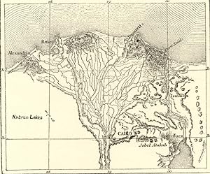
CAIRO AND THE DELTA OF THE NILE ,ANTIQUE 1880s WOOD ENGRAVED MAP
Publicado por Reclus
Librería: Artisans-lane Maps & Prints, Victoria, BC, Canada
Valoración del vendedor:
Arte / Grabado / Póster
no binding. Condición: very good. 1880s HISTORICAL RELIEF MAP CHART SHOWING TERRAIN, TOPOGRAPHY, ENVIRONS Approximate Image Size : 4 1/2 x 4 inches Approximate Overall Size: 7 x 10 1/2 inches Cairo is located on the banks and islands of the Nile River in the north of Egypt, immediately south of the point where the river leaves its desert-bound valley and breaks into three branches into the low-lying Nile Delta region. The oldest part of the city is somewhat east of the river. There, the city gradually spreads west, engulfing the agricultural lands next to the Nile. These western areas, built on the model of Paris by Ismail the Magnificent in the mid-19th century, are marked by wide boulevards, public gardens, and open spaces. The older eastern section of the city is very different: having grown up haphazardly over the centuries it is filled with small lanes and crowded tenaments. While western Cairo is dominated by the government buildings and modern architecture, the eastern half is filled with hundreds of ancient mosques that act as landmarks. Extensive water systems have also allowed the city to expand east into the desert. Bridges link the Nile islands of Gezira and Roda, where many government buildings are located and government officials live. Bridges also cross the Nile attaching the city to the suburbs of Giza and Imbabah (part of the Cairo conurbation). West of Giza, in the desert, is part of the ancient necropolis of Memphis on the Giza plateau, with its three large pyramids, including the Great Pyramid of Giza (last surviving of the Seven Ancient Wonders of the World). Approximately 11 miles (18 km) to the south of modern Cairo is the site of the ancient Egyptian city of Memphis and adjoining necropolis of Saqqara. These cities were Cairo's ancient predecessors, when Cairo was still in this approximate geographical location. CONDITION: BOOKPLATE INTEXT MAP - Excellent Condition. Map Image is clean, clear, sharp with beautiful detail. As scanned. There is TEXT AND INTEXT ENGRAVING ON THE REVERSE SIDE. Printed on cream color coated paper. NOTE THE FOLLOWING BEFORE YOU PURCHASE: This is a GENUINE 1800s Antique Map PRINT. It is NOT a modern reproduction, ie. a laser scan, photocopy etc. It is the original from the antique atlas or book publication. This map was published on the date mentioned, or circa of the date mentioned at the top of the page. The map print I have for sale, like many 1800s Antique Maps and prints that you see online, originate from an antique book or atlas publication. The publication may not always be known. If you have any questions, emails are welcome.
-

Christianity and Monasticism in Northern Egypt: Beni Suef, Giza, Cairo, and the Nile Delta
Publicado por The American University in Cairo Press, 2017
ISBN 10: 9774167775ISBN 13: 9789774167775
Librería: Powell's Bookstores Chicago, ABAA, Chicago, IL, Estados Unidos de America
Miembro de asociación: ABAA ILAB
Valoración del vendedor:
Libro Original o primera edición
Condición: New. 2017. 1st Edition. hardcover. New. Dust Jacket is Fine.
-
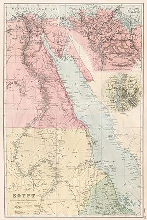
Condición: Good. EGYPT & NILE VALLEY.Inset Delta & Suez Canal;Cairo.Battlefields.BACON 1893 map. Antique colour map; GW Bacon (1893). 48.0 x 32.0cm, 18.75 x 12.5 inches; this is a folding map. Condition: Good. The image shown may have been taken from a different example of this map than that which is offered for sale. The map you will receive is in good condition but there may be minor variations in the condition from that shown in the image. There is nothing printed on the reverse side, which is plain.
-
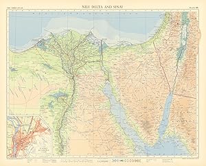
Condición: Good. Nile Delta and Sinai. Cairo plan. Egypt. Eilat. Sharm el Sheikh. TIMES 1956 map. Vintage coloured map; John Bartholomew & son (1956). 48.0 x 59.5cm, 19 x 23.5 inches; this is a folding map. Condition: Good. There is nothing printed on the reverse side, which is plain.
-
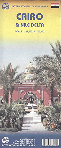
Cairo & Nile Delta 1:12,5k / 1:700k Road and Travel Map (Egypt) (International Travel Maps) (French
Publicado por ITMB Publishing Ltd., 2008
ISBN 10: 1553416252ISBN 13: 9781553416258
Librería: Save With Sam, North Miami, FL, Estados Unidos de America
Valoración del vendedor:
Libro
Paperback. Condición: New. Brand New!.
Más opciones de compra de otros vendedores en IberLibro
Nuevo desde EUR 51,26
Usado desde EUR 48,28
Encuentre también Tapa blanda
-
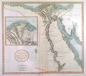
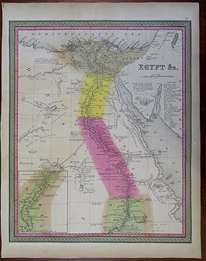
Egypt Nile Delta Cairo Alexandria Nubia Red Sea 1848 Cowperthwait Mitchell map
Ańo de publicación: 1848
Librería: RareMapsandBooks, Dover, NH, Estados Unidos de America
Miembro de asociación: ESA IOBA
Valoración del vendedor:
Mapa
Condición: good. Egypt &c.(Old Maps, 19th Century Maps, Africa, North Africa, Egypt, Nile River, Cairo, Alexandria, Nubia, Red Sea). Issued 1848, Philadelphia by Cowperthwaite for S. A. Mitchell. Lovely 19th century engraved and lithographed map with original hand color. Mitchell maps of this mid-century era were issued with a range of color as well as variant decorative borders. Nice looking example, clean and fresh, pleasing age patina, any small age spots or minor age flaws easy to overlook or forgive. Sheet Measures c. 12 1/2" H x 15 1/4" W. Engraved Area Measures c. 10 1/2" H x 13 1/2" W. Cartographic Reference (s):Reps, American Maps and Mapmakers, p. 313. Tooley's Dictionary of Mapmakers, vol. 4, pp. 260.[R29739].
-
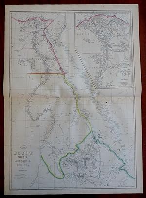
Egypt Nubia Abyssinia Nile Delta Red Sea Cairo Alexandria c. 1856-72 Weller map
Ańo de publicación: 1856
Librería: RareMapsandBooks, Dover, NH, Estados Unidos de America
Miembro de asociación: ESA IOBA
Valoración del vendedor:
Mapa
Condición: good. Egypt, Nubia, Abyssinia, and the Red Sea.(Old Maps, 19th Century Maps, Africa, East Africa, North Africa, Egypt, Nubia, Abyssinia, Nile Delta, Cairo, Alexandria, Red Sea). Issued c. 1856-72, London by Edward Weller for the Weekly Dispatch Atlas. Mid 19th century lithographed map with original outline hand color. A relatively uncommon map which was among maps issued in weekly installments for many years by this firm. Typical signs of time and wear soft old crease lines which are easy to overlook. Original center fold as issued. Sheet Measures c. 25" H x 18 1/4" W. Printed Area Measures c. 23 1/4" H x 17" W. Cartographic Reference (s):Tooley's Dictionary of Mapmakers, vol. 4.[R30334].
-

Amsterdam, 1988. 325 pp., ills/maps, 4to, pap. Front cover small crack, but else excellent.
-
BIRDSEYE VIEW OF EGYPT . Shows Cairo and the Nile Delta in great detail. The coast stretches from Port Said in the east, to Alexandria in the west. An inset plan of Alexandria and of the Mediterranean.
Publicado por The Graphic 1882, 1882
Mapa
Tinted wood engraving, 36 x 57 cm.
-
A NEW MAP OF EGYPT. . Map of Egypt, reaching south to Assuan, with large inset map of the Nile delta from Cairo to the Sea.
Publicado por John Cary 1805, 1805
Mapa
48x53cm. Full original colour. Excellent condition.
-
The Story of the Cape to Cairo Railway and River Route, from 1887 to 1922. VOLS I-III. Plus INDEX to Vols I., II. & III. [3 VOLS ONLY + MAPS & INDEX - Lacking vol iv. ] Vol I: The Romance of a Great Project and How it has Materialised; Vol II: The Main Line as it exists to-day from the Cape to the Nile Delta; Vol III: Variations of the Main Trunk Route and its Feeder Lines in Existence or Projected. Africa's Native Tribes and Wild Game; Index to Vols I, II and III.
Publicado por London The Pioneer Publishing Co., Ltd, 1926, 1926
Librería: Chaucer Bookshop ABA ILAB, Canterbury, Reino Unido
Miembro de asociación: ABA ILAB
Valoración del vendedor:
Three Vols + Index Volume. (Lacking Vol IV). 4to., bound in publisher's three-quarters black morocco gilt with green buckram boards, t.e.g. Vols I-III illus with sepia tissue-protected portraits, b/w plates and maps (some foldout) plus some in colour; Map and Index Vol complete with all 12 foldout maps in card case to front pastedown, plus 49pp index, illus with b/w plates and a map. Vol I: [xxxvi] + 727pp; Vol II: [xx] + 510pp; Vol III: [xvi] + 454pp. Clean set with no previous ownership inscriptions or annotation. Inner hinges of Vols I-III reinforced with green tape. Vol I front inner hinge beginning to split. Foxing to edges to Vols I-III. Slight rubbing to boards, board edges and corners, and a few marks. Ovefrall a VG set. (SHELF 133) PLEASE NOTE: very Heavy set - Postage outside the UK WILL incur a surcharge: BEFORE ORDERING PLEASE CONTACT US VIA E-MAIL FOR AN ACCURATE QUOTE. ** Pictures available upon request, if not already displayed here.** The shop is open 7 days a week. Over 20,000 books in stock - come and browse. PayPal, credit and most debit cards welcome. Books posted worldwide. For any queries please contact us direct.


![Imagen del vendedor de The Story of the Cape to Cairo Railway and River Route, from 1887 to 1922. VOLS I-III. Plus INDEX to Vols I., II. & III. [3 VOLS ONLY + MAPS & INDEX - Lacking vol iv. ] Vol I: The Romance of a Great Project and How it has Materialised; Vol II: The Main Line as it exists to-day from the Cape to the Nile Delta; Vol III: Variations of the Main Trunk Route and its Feeder Lines in Existence or Projected. Africa's Native Tribes and Wild Game; Index to Vols I, II and III. a la venta por Chaucer Bookshop ABA ILAB](https://pictures.abebooks.com/inventory/md/md30471075298.jpg)