Importe total (1 artículo artículos):
Destino del pedido:

amérique méridionale de levasseur (10 resultados)
Ir a los resultados principales
Tipo de artículo
- Todo tipo de artículos
- Libros (8)
- Revistas y publicaciones
- Cómics
- Partituras
- Arte, grabados y pósters (1)
- Fotografías
- Mapas (1)
-
Manuscritos y
coleccionismo de papel
Condición
- Todo
- Nuevos
- Antiguos o usados
Encuadernación
- Todo
- Tapa dura
- Tapa blanda
Más atributos
- Primera edición
- Firmado
- Sobrecubierta
- Con imágenes del vendedor
- Sin impresión bajo demanda
Ubicación del vendedor
Valoración de los vendedores
-
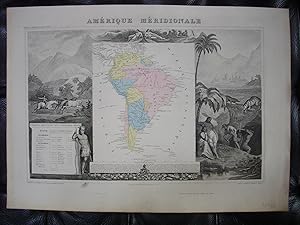
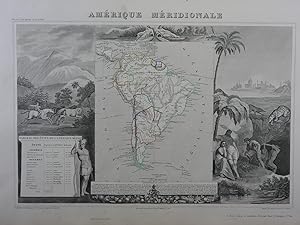
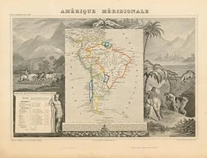
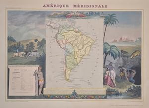
Carte de l'AMÉRIQUE MÉRIDIONALE (extraite de l'Atlas National illustré des 89 Départements et des Possessions de la France, par Levasseur V., publiée par Pelissier, édition de 1869)
Publicado por Pelissier, Paris, 1869
Librería: Librairie Rouchaleou, MONTPELLIER, FR, Francia
Valoración del vendedor:

Pas de couverture. Condición: Trčs bon. 1 carte géographique gravée ancienne de l'AMÉRIQUE MÉRIDIONALE, imprimée sur papier fort et coloriée ŕ l'époque, de format : 36,5 x 51,5 cm. Carte originale gravée sur acier, illustrée d'un décor d'encadrement finement gravé figurant la géographie et l'histoire de l'Amérique méridionale (paysages), avec un cartouche donnant une notice écrite de la statistique de de l'Amérique méridionale. Les fonds de chacune des contrées décrites sur cette carte de l'AMÉRIQUE MÉRIDIONALE sont aquarellés chacun d'une couleur différente (original hand coloring). Carte dressée d'aprés les travaux du Cadastre de dępot de la Guerre et des Ponts et Chaussées par V. Levasseur, ingénieur Géographe attaché au Génie du Cadastre de la Ville de Paris. Bel exemplaire ( Photographies sur demande / We can send pictures of this print on simple request ) Envoi dans un emballage de protection (tube carton).
-
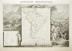
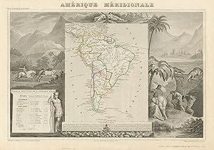
CARTE HISTORIEE - AMERIQUE MERIDIONALE - Carte ancienne (53x36cm) gravée sur acier provenant de l'ATLAS NATIONAL ILLUSTRÉ de Victor LEVASSEUR. 1852. Coloris manuels d'époque.
Publicado por A. COMBETTE,, Paris,, 1852
Librería: Librairie Christian Chaboud, Bruxelles, Belgica
Valoración del vendedor:
53x36cm, Bel état de fraîcheur. La carte est illustrée en encadrement de fines gravures et d'informations sur le continent. Carte telle que parue, sans pliure centrale, complčte de toutes ses marges, provenant de l' Atlas National Illustré des 86 Départements et des Possessions de la France Divisé par Arrondissements, Cantons et Communes avec le tracé de toutes les routes, chemins de fer et canaux. Dressée d'aprčs les Travaux du Cadastre du Dépôt de la guerre et des Ponts et Chaussées.
-
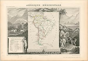
Condición: Trčs bon. Carte originale 53 x 36 cm extraite de l'Atlas national illustré des 86 départements et des possessions de la France, divisé par arrondissements, cantons et communes, avec le tracé de toutes les routes, chemins de fer et canaux. Dressé d'aprčs les travaux du cadastre, du Dépôt de la Guerre, et des Ponts et chaussées. Gravé sur acier par les meilleurs artistes. Bel exemplaire.
-
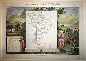
Condición: Good. AMÉRIQUE MERIDIONALE. South America. Antique map/carte. LEVASSEUR 1856 old. Antique steel engraved map with outline hand colour (color) applied at the time of printing. Wide margins; Victor Levasseur (1856). 30.5 x 43.0cm, 12 x 17 inches. Condition: Good. The image shown may have been taken from a different example of this map than that which is offered for sale. The map you will receive is in good condition but there may be minor variations in the condition from that shown in the image. This map was coloured by hand at the time of publication, thus the colouration may vary slightly between different examples of the map; the colouring applied to the map you receive may differ slightly from that shown in the image. There is nothing printed on the reverse side, which is plain.
-
Amerique Méridionale
Publicado por America Meridionale
Librería: Sergio Trippini, Gavirate, Italia
Miembro de asociación: ALAI ILAB
Valoración del vendedor:
Carta geografica dell'America meridionale, entro ricca e decorativa cornice, confini colorati all'epoca.
-
Amerique Meridionale - Spectacular view of South America from the mid-19th century.
Publicado por c. 1845, 1845
Librería: Curtis Wright Maps, Berwyn, IL, Estados Unidos de America
Miembro de asociación: ESA MWABA
Valoración del vendedor:
Condición: Fine. This attractive steel engraved map of South America shows the continent at a period of tremendous political development. Successful independence movements from Spanish and Portuguese control swept through most of the territory (with the notable exceptions of French, Dutch, and British Guyana) during the prior four decades, though national boundaries continued to change regularly depending on negotiations (and conflicts) between subsequent governments. Surrounding the map is a lavishly decorated scene that is representative of contemporary European perspectives on South America. Exotic animals, lush flora, mineral resources, and inhabitants ranging from the 'civilized' gaucho riding horses to the scantily clad indigenous tribesman. The latter is standing adjacent to a table of demographic statistics, while a summary of South American history and geography is provided (in French) at the bottom of the page. The map was created by Victor Levasseur around 1845 for inclusion in his notable Atlas Universel Illustre, published in Paris by Amable Combette. Engraving by Laguillermie, printing by Lemercier, and illustrations by Raimond Bonheur, father of Rosa Bonheur, the famous painter of animals. Sheet Width (in) 19.8 Sheet Height (in) 13.6 Condition Description A few dirty fingerprints in the lower left corner and slight toning around the outer edges of the sheet, consistent with age. Very good overall, with original outline color.
-
Amérique Méridionale.
Librería: Librería Anticuaria Antonio Mateos, Malaga, Espańa
Miembro de asociación: AILA ILAB
Valoración del vendedor:
Paris, Chez A. Combelle (Imp. Lemercier), sin fecha (hacia 1852), mapa de América del Sur con los contornos coloreados , con fondo de paisajes con nativos y animales dibujado por Raimond Bonheur, magníficamente coloreado a mano. (Del "Atlas Universel Illustré"; contiene nota con explicación del mapa y tabla de los países que lo integran).
-
Amérique Méridionale
Publicado por Artist: Lemercier / Levasseur ( - 1870 ) Paris ; issued in: Paris ; ca: 1850; - Cadastre of the War and Bridge Department by V Levasseur Geographer Engineer attached to the Cadastre and the City of Paris Huge Parisian firm of lithographic printers founded by Joseph Rose Lemercier (1803-1887) who began as the foreman for Langlumé in 1825 Working on his own account from 1827 1829-36 in partnership with Bénard association formed in 1837 according to IFF catalogue for Joseph Lemercier The firm was still active in 1841, 1800
Librería: Antique Sommer& Sapunaru KG, München, Alemania
Miembro de asociación: ILAB VDA
Valoración del vendedor:

Technic: Lithography; colorit: original colored; condition: Left margin partly replaced, size (in cm): 30 x 42,5; - Map shows South America, beautiful sourrounded by typical scenes of natives and their life.
-
Atlas National Illustre des 86 Departments et des Possessions De La France. Divise par Arrondissements, Cantons et Communes Avec Le Trace De Toutes Les Routes, Chemins De Fer Et Canaux. Dresse d'apres les Travaux du Cadastre du Depot de la Guerre et des Ponts et Chaussees, par V. Levasseur, Ingenieur Geographe attache au Genie du Cadastre et de la Ville de Paris. Grave Sur Acier Par Les Meilleurs Artistes. (With Amérique Méridionale and Amérique Septentrionale) . First édition.
Publicado por Paris: Combette, 1854
Librería: Wittenborn Art Books, San Francisco, CA, Estados Unidos de America
Valoración del vendedor:
Arte / Grabado / Póster
Condición: Good. Folio. Contemporary half calf worn, but solid. 36 x 53.5 cm. Engraved title and chart and 100 contemporary handcolored maps, including a few of Europe and the world and a double page map of the Routes de la poste . OCLC Number: 557423596.Includes the maps of Amérique Méridionale and Amérique Septentrionale as well as French colonies and other continents.This atlas is noteworthy for its beautiful illustrations in the borders of the maps. It was one of the last of the decorative map atlases of the 19th century, along with Tallis and Fullarton. Victor Levasseur, an important French engineer, cartographer, and engraver of the mid 19th century, held a number of important cartographically related political and educations posts in France. He is most famous for his "Atlas National Illustre des 86 Departments et des Possessions De La France. Divise par Arrondissements, Cantons et Communes Avec Le Trace De Toutes Les Routes, Chemins De Fer Et Canaux. Dresse d'apres les Travaux du Cadastre du Depot de la Guerre et des Ponts et Chaussees, par V. Levasseur, Ingenieur Geographe attache au Genie du Cadastre et de la Ville de Paris. Grave Sur Acier Par Les Meilleurs Artistes. Publie par A. Combette Editeur Paris. 1856. Rue de la Parcheminerie No. 15. (title page only) Impie. de Lemercier, Paris. Eug. Duchez.", a large decorative atlas of France, including his Planisphere and five important continental maps. The first publication of this particular atlas was in 1847. Most of Levasseur's work was produced between 1838 and 1855. Levasseur's maps are distinctive for their wide decorative margins containing elaborate depictions of the scenery, peoples, and trade goods of the areas he mapped. Levasseur maps are also known to offer a wealth of statistical data. in-folio, 100 cartes en couleurs, reliure demi-veau vert bouteille, dos lisse usé. L'ouvrage contient les 93 planches coloriées d'époque avec les départements, les colonies contenues dans la table, les continents, ainsi q'une carte de France des routes et chemins de fer par Charle.
-
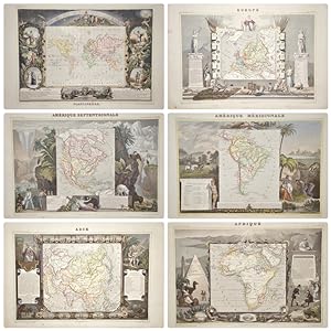
Europe, Afrique, Asie, Océanie, Amérique septentrionale, Amérique Méridionale
Publicado por Artist: Lemercier / Levasseur ( - 1870 ) Paris ; issued in: Paris ; ca: 1845; - Cadastre of the War and Bridge Department by V Levasseur Geographer Engineer attached to the Cadastre and the City of Paris Huge Parisian firm of lithographic printers founded by Joseph Rose Lemercier (1803-1887) who began as the foreman for Langlumé in 1825 Working on his own account from 1827 1829-36 in partnership with Bénard association formed in 1837 according to IFF catalogue for Joseph Lemercier The firm was still active in 1841, 1800
Librería: Antique Sommer& Sapunaru KG, München, Alemania
Miembro de asociación: ILAB VDA
Valoración del vendedor:
Technic: Lithography; colorit: original colored; condition: Perfect condition, size (in cm): 30,5 x 44; - Very decorativ set of 6 maps depicting the continent of Europe, Africa, Oceania, North and South America. All maps are sopurrounded by views an typical scenes of the continents.