Importe total (1 artÚculo artÚculos):
Destino del pedido:

adolf hand atlas theile de stieler (6 resultados)
Ir a los resultados principales
Tipo de artÚculo
- Todo tipo de artÚculos
- Libros (6)
- Revistas y publicaciones
- Cµmics
- Partituras
- Arte, grabados y pµsters
- FotografÚas
- Mapas
-
Manuscritos y
coleccionismo de papel
Condiciµn
- Todo
- Nuevos
- Antiguos o usados
Encuadernaciµn
MÃs atributos
- Primera ediciµn
- Firmado
- Sobrecubierta
- Con imÃgenes del vendedor (5)
- Sin impresiµn bajo demanda
Ubicaciµn del vendedor
Valoraciµn de los vendedores
-

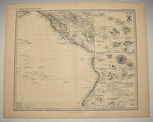
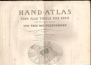
Aus: Hand-Atlas ■ber alle Theile der Erde und ■ber das Weltgebðude. Herausgegeben von Adolf Stieler.
Publicado por Gotha, Perthes, 1880., 1880
Librería: Antiquariat MEINDL & SULZMANN OG, Wien - Vienna, Austria
Valoraciµn del vendedor:

Ca. 29 x 35 cm. Graphik - Landkarten.
-
Antique Map of Der Grosse Ocean. MAP Pacific Ocean North & South American Pacific Islands GERMAN TEXT. Hand Atlas Uber Alle Theile Der Erde Und Uber Das Weltgebaude. Herausgegeben Von Adolf Stieler. Gotha Justus Perthes.
Publicado por Petermann 1891, 1891
Librería: PROCTOR / THE ANTIQUE MAP & BOOKSHOP, DORCHESTER, Reino Unido
Miembro de asociaciµn: PBFA
Valoraciµn del vendedor:
PLATE number 76 Plate Size 17 inches x 14 inches. Line Coloured Engraving. Unframed In very good condition. Some light tanning on edges. Insets down the right include Hawaii and Honolulu. Stieler maps went through continual revisions.
-
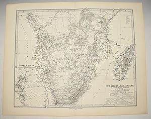
Antique Map of Sub-Afrika & Madagaskar. MAP SOUTH AFRICA MADAGASCAR CAPE TOWN TRANSVAAL REPUBLIC MOZAMBIQUE ANGOLA GERMAN TEXT. Hand Atlas Uber Alle Theile Der Erde Und Uber Das Weltgebaude. Herausgegeben Von Adolf Stieler. Gotha Justus Perthes.
Publicado por Gotha Justus Perthes 1878, 1878
Librería: PROCTOR / THE ANTIQUE MAP & BOOKSHOP, DORCHESTER, Reino Unido
Miembro de asociaciµn: PBFA
Valoraciµn del vendedor:
PLATE number 71 Plate Size 17 inches x 14 inches. Line Coloured Engraving. Unframed In very good condition. Some light tanning on edges.
-
Adolf Stieler's Hand-Atlas ■ber alle Theile der Erde und ■ber das Weltgebðude
Publicado por Gotha, Justus Perthes, 1893, 1893
Librería: Buchfink Das fahrende Antiquariat, Brugg, AG, Suiza
Valoraciµn del vendedor:
Halbleder, gebunden; schwarzes Éberzugspapier, brauner R■cken, Goldprðgung, mit Leder verstðrkte Ecken / Anz. Seiten: 201 / 28 x 39 cm / mit 95 kolorierten, gestochenen Karten / Zustand: gut, leichte bis mðssige Gebrauchsspuren; Einband berieben, Ecken bestossen/beschabt, Kapitale auf je 2 cm weggerissen, 1 Doppeltafel lose, vereinzelte Tafeln gering stockfleckig, Besitzereintrag und -stempel auf Vorsatz Sprache: de.
-
Hand-Atlas ■ber alle Theile der Erde nach dem neuesten Zustande und ■ber das Weltgebðudes. Herausgegeben von Adolf Stieler, C. G. Reichhard, H. H■bbe, F. v. St■lpnagel, H. Berhaus u. I. C. Bðr.
Publicado por Gotha, J. Perthes [1839]., 1839
Librería: Antiquariat Burgverlag, Wien, Austria
Miembro de asociaciµn: ILAB VDA VDAO
Valoraciµn del vendedor:

qu.-2¯. 59 (v. 63) doppeblattgr. grenzkolor. Kupferkarten (2-32, 36-61, 63). inkl. Titelbl. mit Plan von Gotha und Umgebung (dat. 1831). HLdr. d. Zt. Einbandkanten stðrker berieb., Einzelne Karten leicht fleckig u. mit fachmðnnisch reparierten Randlðsuren. Kl. RandausriÔ in Karte 11. Hintergelenk locker. Espenhorst 2.1.1.1.1 - Fr■her, fast vollstðndiger Stieler-Atlas. Es fehlen 4 Karten: Australien und Neuseeland, Benelux-Staaten, Schweiz, Italien-Gesamtansicht. . Die Titelvignette (Plan von Gotha) ist mit 1831 datiert. Det Kongelige Bibliotek, Dðnemark gibt f■r das Jahr 1834 die Anzahl der Karten mit 63 an. Im Jahr 1837 wurde die letzte auf 1816 datierte Karte (Bl. 8) durch eine eine neue Bearbeitung ersetzt. (Espenhorst, Bibliographie S. 69. In diesem Exemplar trðgt die Karte No. VIII das Datum 1832. Bis 1840 wurden die Ausgaben `Neue Ausgabe` genannt. (Espenhorst, Bibliographie S. 69). Das hier vorliegende Exemplar trðgt auf jedem Kartenblatt die Worte: `Neue Ausgabe`. Ab 1841/1842 wurde die Blatt■bersicht auf Bllatt 2 durch eine Darstellung des Erdmondes ersetzt. (Espenhorst, Bibliographie S. 68). In dem vorlliegenden Exemplar findet sich die Darstellung des Planeten-Systems. Gewicht in Gramm: 5000.
-
Hand Atlas Uber Alle Theile Der Erde Und Uber Das Weltgebaude. Herausgegeben Von Adolf Stieler. Gotha Justus Perthes. (81 Maps | Au
Publicado por Gotha Justus Perthes., 1867
Librería: Ziern-Hanon Galleries, Frontenac, MO, Estados Unidos de America
Valoraciµn del vendedor:

Disbound. Condiciµn: Very Good. This is a portfolio of 81 maps and drawings. No previous owner's names, not exlibrary. Hand colored in outline. Overall in VERY GOOD condition. Photos available upon request. Size: 18.5 x 15 inches (46 x 31 cms). LARGE. Hand colored in outline. Overall in GOOD condition. Photos available upon request. Size: 18.5 x 15 inches (46 x 31 cms). LARGE. This portfolio has 3 extra maps (variants of other ones present) and it is lacking the following 6 maps: #12. Europa zur Ubersicht der politischen Verhaltnisse; #39. Asia. Generalkarte; #41a. America. Generalkarte; #43c. China (ostl. Theil), Korea und Japan; #44c. Di Ostindischen Inseln; #51. Polynesian und der Grosse Ocean. Westl. Theil. JOHAN GEORG JUSTUS PERTHES (1749-1816), German publisher, was born at Rudolstadt on the Iith of September 1 749. In 1785 he founded at Gotha the business which bears his name (Justus Perthes). In this he was joined in 1814 by his son Wilhelm (1793-1853), who had been in the establishment of Justus' nephew, Friedrich Christoph Perthes, at Hamburg. On the death of Justus at Gotha on the 2nd of May 1816, Wilhelm took entire control of the firm. He laid the foundation of the geographical branch of the business, for which it is chiefly famous, by publishing the Hand-atlas (1817-1823) of Adolf Stieler (1775-1836). Wilhelm Perthes engaged the collaboration of the most eminent, German geographers of the time, including Heinrich Berghaus, Christian Gottlieb Reichard (1758-1837), who was associated with Stieler in the compilation of the atlas, Karl Spruner (1803-1892) and Emil von Sydow (1812-1873). The business passed to his son Bernard Wilhelm Perthes (1821-1857), who was associated with August Petermann (under whose direction the well-known periodical Petermanns Mitteilungen was founded) and Bruno Hassenstein (1839-1902); and subsequently to his son Bernard (1857-). In 1863 the firm first issued the Almanach de Gotha, a statistical, historical and genealogical annual (in French) of the various countries of the world; and in 1866 the elaborate Geographisches Jahrbuch was produced under the editorship of Ernst Behm (1830-1884), on whose death it was continued under that of Professor Hermann Wagner. Size: Elephant Folio - over 15" - 23" tall. Hardcover.