
Importe total (1 artículo artículos):
Destino del pedido:

9780721709383 - Map of UK and Ireland - Laminated (53 x 77cm) de Schofield & Sims (15 resultados)
Ir a los resultados principales
Tipo de artículo
- Todo tipo de artículos
- Libros (14)
- Revistas y publicaciones
- Cómics
- Partituras
- Arte, grabados y pósters
- Fotografías
- Mapas (1)
-
Manuscritos y
coleccionismo de papel
Condición
Encuadernación
- Todo
- Tapa dura
- Tapa blanda (2)
Más atributos
- Primera edición
- Firmado
- Sobrecubierta
- Con imágenes del vendedor (7)
- Sin impresión bajo demanda
Ubicación del vendedor
Valoración de los vendedores
-

Map of Uk and Ireland
Publicado por Schofield & Sims Ltd, 2012
ISBN 10: 0721709389ISBN 13: 9780721709383
Librería: GreatBookPrices, Columbia, MD, Estados Unidos de America
Valoración del vendedor:

Libro
Condición: As New. Unread book in perfect condition.
-

Map of Uk and Ireland
Publicado por Schofield & Sims Ltd, 2012
ISBN 10: 0721709389ISBN 13: 9780721709383
Librería: GreatBookPrices, Columbia, MD, Estados Unidos de America
Valoración del vendedor:
Libro
Condición: New.
-

Map of UK and Ireland
Publicado por Schofield and Sims Ltd, 2002
ISBN 10: 0721709389ISBN 13: 9780721709383
Librería: PBShop.store US, Wood Dale, IL, Estados Unidos de America
Valoración del vendedor:
Libro
UNK. Condición: New. New Book. Shipped from UK. Established seller since 2000.
-
Map of UK and Ireland
Publicado por Schofield & Sims Ltd, 2002
ISBN 10: 0721709389ISBN 13: 9780721709383
Libro
Paperback. Condición: New. BRAND NEW ** SUPER FAST SHIPPING FROM UK WAREHOUSE ** 30 DAY MONEY BACK GUARANTEE.
-
Map of UK and Ireland
Publicado por Schofield & Sims Ltd, 2012
ISBN 10: 0721709389ISBN 13: 9780721709383
Librería: Ria Christie Collections, Uxbridge, Reino Unido
Valoración del vendedor:
Libro
Condición: New. In.
-
Map of UK and Ireland
Publicado por Schofield & Sims Ltd, 2012
ISBN 10: 0721709389ISBN 13: 9780721709383
Libro
Condición: new.
-
Map Of Uk And Ireland
Publicado por Schofield & Sims Ltd, 2002
ISBN 10: 0721709389ISBN 13: 9780721709383
Mapa
Map. Condición: Brand New. 1 pages. 42.99x2.56x2.44 inches. In Stock.
-
Map of UK and Ireland
Publicado por Schofield & Sims Ltd, 2012
ISBN 10: 0721709389ISBN 13: 9780721709383
Librería: Kennys Bookshop and Art Galleries Ltd., Galway, GY, Irlanda
Valoración del vendedor:
Libro
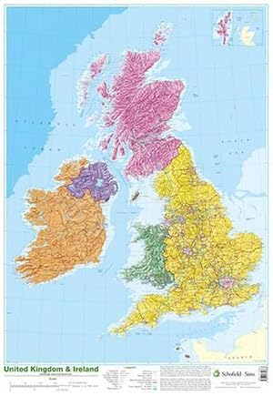
Condición: New. 2012. Map. This detailed relief map of the United Kingdom and Ireland is colour coded to show the area of each country and large city. BIC Classification: 1DBK; 1DBR; WTRM; YRW; YZ. Category: (J) Children / Juvenile. Dimension: 760 x 520 x 1. Weight in Grams: 155. . . . . .
-
Map of Uk and Ireland
Publicado por Schofield & Sims Ltd, 2012
ISBN 10: 0721709389ISBN 13: 9780721709383
Librería: GreatBookPricesUK, Castle Donington, DERBY, Reino Unido
Valoración del vendedor:

Libro
Condición: New.
-
Map of UK and Ireland
Publicado por Schofield & Sims Ltd, 2012
ISBN 10: 0721709389ISBN 13: 9780721709383
Librería: Kennys Bookstore, Olney, MD, Estados Unidos de America
Valoración del vendedor:
Libro
Condición: New. 2012. Map. This detailed relief map of the United Kingdom and Ireland is colour coded to show the area of each country and large city. BIC Classification: 1DBK; 1DBR; WTRM; YRW; YZ. Category: (J) Children / Juvenile. Dimension: 760 x 520 x 1. Weight in Grams: 155. . . . . . Books ship from the US and Ireland.
-
Map of Uk and Ireland
Publicado por Schofield & Sims Ltd, 2012
ISBN 10: 0721709389ISBN 13: 9780721709383
Librería: GreatBookPricesUK, Castle Donington, DERBY, Reino Unido
Valoración del vendedor:
Libro
Condición: As New. Unread book in perfect condition.
-
Map of UK and Ireland
Publicado por Schofield and Sims Ltd, 2002
ISBN 10: 0721709389ISBN 13: 9780721709383
Librería: PBShop.store UK, Fairford, GLOS, Reino Unido
Valoración del vendedor:
Libro
UNK. Condición: New. New Book. Shipped from UK. Established seller since 2000.
-

Map of UK and Ireland
Publicado por SCHOFIELD & SIMS LTD Okt 2002, 2002
ISBN 10: 0721709389ISBN 13: 9780721709383
Libro
Taschenbuch. Condición: Neu. Neuware - This detailed relief map of the United Kingdom and Ireland is colour coded to show the area of each country and large city.
-
Map of UK and Ireland
Publicado por Schofield & Sims Ltd, West Yorkshire, 2002
ISBN 10: 0721709389ISBN 13: 9780721709383
Librería: AussieBookSeller, Truganina, VIC, Australia
Valoración del vendedor:
Libro
Condición: new. This detailed relief map of the United Kingdom and Ireland is colour coded to show the area of each country and large city. County boundaries are marked, as are rivers, motorways, ports and airports. An explanation of the political relationship between the countries is given, alongside information about the distance from sea level to Ben Nevis. This detailed relief map of the United Kingdom and Ireland is colour coded to show the area of each country and large city. Shipping may be from our Sydney, NSW warehouse or from our UK or US warehouse, depending on stock availability.
-

Map of UK and Ireland
Publicado por Schofield & Sims Ltd, 2002
ISBN 10: 0721709389ISBN 13: 9780721709383
Libro
Condición: New. This detailed relief map of the United Kingdom and Ireland is colour coded to show the area of each country and large city.KlappentextrnrnThis detailed relief map of the United Kingdom and Ireland is colour coded to show the area of each cou.