
Importe total (1 artículo artículos):
Destino del pedido:

michelin editions des voyages apr 2016 (14 resultados)
Ir a los resultados principales
Tipo de artículo
- Todo tipo de artículos
- Libros (14)
- Revistas y publicaciones
- Cómics
- Partituras
- Arte, grabados y pósters
- Fotografías
- Mapas
-
Manuscritos y
coleccionismo de papel
Condición
- Todo
- Nuevos
- Antiguos o usados
Encuadernación
- Todo
- Tapa dura (2)
- Tapa blanda
Más atributos
- Primera edición
- Firmado
- Sobrecubierta
- Con imágenes del vendedor
- Sin impresión bajo demanda
Ubicación del vendedor
Valoración de los vendedores
-
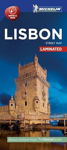
Lisbon - Michelin City Map 9208 : Laminated City Plan
Publicado por Michelin Editions Des Voyages Apr 2016, 2016
ISBN 10: 2067214152ISBN 13: 9782067214156
Libro
Karte. Condición: Neu. Neuware - Discover Lisbon by foot, car or bike using Michelin Lisbon City Plan (scale 1/17,000 cm). In addition to Michelin's clear and accurate mapping, this city plan will help you explore and navigate across Lisbon's different districts thanks to its full index, its comprehensive key showing places of interest and tourist attractions, as well as practical information on public transport leisure facilities, service stations and shops!Discover the new range of Michelin City Maps\* Write on Wipe off ,Draw your route with a felt tipped pen, Erase with a damp cloth!\* Plastic Format\* Durable and convenient to use\* Handy Compact, folds 'free' for easy handling\* Clarity and legibility of Michelin mapping:\* Map of the city centre with identified tourist sites\* Green Guide tourist sites\* Smaller Map of whole city\* Underground Map, with a detailed index 1 pp. Deutsch.
-
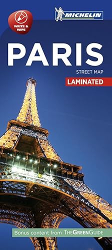
Paris - Michelin City Map 9202 : Laminated City Plan
Publicado por Michelin Editions Des Voyages Apr 2016, 2016
ISBN 10: 2067214217ISBN 13: 9782067214217
Libro
Karte. Condición: Neu. Neuware - (Updated 2019) Discover Paris by foot, car or bike using Michelin Paris City Plan (with Street index, scale 1/17,000 cm). In addition to Michelin's clear and accurate mapping, this city plan will help you explore and navigate across Paris different districts thanks to its full index, its comprehensive key showing places of interest and tourist attractions, as well as practical information on public transport leisure facilities, service stations and shops!Discover the new range of Michelin City Maps\* Write on Wipe off ,Draw your route with a felt tipped pen, Erase with a damp cloth!\* Plastic Format\* Durable and convenient to use\* Handy Compact, folds 'free' for easy handling\* Clarity and legibility of Michelin mapping:\* Map of the city centre with identified tourist sites\* Green Guide tourist sites\* Smaller Map of whole city\* Underground Map, with a detailed index 1 pp. Deutsch.
-

Finistere, Morbihan - Michelin Local Map 308 : Map
Publicado por Michelin Editions Des Voyages Apr 2016, 2016
ISBN 10: 2067210033ISBN 13: 9782067210035
Libro
Karte. Condición: Neu. Neuware - (Edition updated in 2018) The MICHELIN Finistere, Morbihan local map, scale 1/150,000 is the ideal companion to fully explore Southern Brittany and provides star-rated Michelin tourist itineraries and attractions, as well as impressive 3D relief mapping. MICHELIN local maps are perfect for cyclists and outdoor enthusiasts with over 20 leisure symbols, extensive coverage of cycling paths and nature trails. With MICHELIN local maps, find more than just your way!MICHELIN LOCAL MAPS provide detailed coverage of France are perfect for fully exploring these countries and are also ideal for cyclists.\* Impressive & realistic 3D relief mapping\* Michelin selected itineraries and must-sees of the area\* A clear and comprehensive key with 20 leisure symbols, as well as cycling paths and nature trails.\* Star rated tourist sights and attractions cross-referenced with the famous MICHELIN Green Guides.\* Plans of main cities and a comprehensive place name index 1 pp. Deutsch.
-
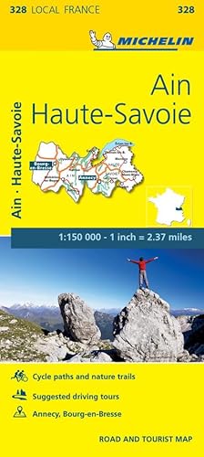
Ain, Haute-Savoie - Michelin Local Map 328 : Map
Publicado por Michelin Editions Des Voyages Apr 2016, 2016
ISBN 10: 2067210459ISBN 13: 9782067210455
Libro
Karte. Condición: Neu. Neuware - (Edition updated in 2018) The MICHELIN Alpes-de-Haute-Provence, Hautes-Alpes local map, scale 1/150,000 is the ideal companion to fully explore the French alps and provides star-rated Michelin tourist itineraries and attractions, as well as impressive 3D relief mapping. MICHELIN local maps are perfect for cyclists and outdoor enthusiasts with over 20 leisure symbols, extensive coverage of cycling paths and nature trails. With MICHELIN local maps, find more than just your way!MICHELIN LOCAL MAPS provide detailed coverage of France are perfect for fully exploring these countries and are also ideal for cyclists.\* Impressive & realistic 3D relief mapping\* Michelin selected itineraries and must-sees of the area\* A clear and comprehensive key with 20 leisure symbols, as well as cycling paths and nature trails.\* Star rated tourist sights and attractions cross-referenced with the famous MICHELIN Green Guides.\* Plans of main cities and a comprehensive place name index 1 pp. Deutsch.
-

Cote-d'Or, Saone-et-Loire - Michelin Local Map 320 : Map
Publicado por Michelin Editions Des Voyages Apr 2016, 2016
ISBN 10: 2067210289ISBN 13: 9782067210288
Libro
Karte. Condición: Neu. Neuware - (Edition updated in 2018) The MICHELIN Cote-d'Or, Saone-et-Loire local map, scale 1/150,000 is the ideal companion to fully explore these French local areas and provides star-rated Michelin tourist itineraries and attractions, as well as impressive 3D relief mapping. MICHELIN local maps are perfect for cyclists and outdoor enthusiasts with over 20 leisure symbols, extensive coverage of cycling paths and nature trails. With MICHELIN local maps, find more than just your way!MICHELIN LOCAL MAPS provide detailed coverage of France are perfect for fully exploring these countries and are also ideal for cyclists.\* Impressive & realistic 3D relief mapping\* Michelin selected itineraries and must-sees of the area\* A clear and comprehensive key with 20 leisure symbols, as well as cycling paths and nature trails.\* Star rated tourist sights and attractions cross-referenced with the famous MICHELIN Green Guides.\* Plans of main cities and a comprehensive place name index 1 pp. Deutsch.
-

Loiret, Loir-et-Cher - Michelin Local Map 318 : Map
Publicado por Michelin Editions Des Voyages Apr 2016, 2016
ISBN 10: 2067210246ISBN 13: 9782067210240
Libro
Karte. Condición: Neu. Neuware - (Edition updated in 2016) The MICHELIN Loiret, Loir-et-Cher local map, scale 1/150,000 is the ideal companion to fully explore part of France's Loire valley and provides star-rated Michelin tourist itineraries and attractions, as well as impressive 3D relief mapping. MICHELIN local maps are perfect for cyclists and outdoor enthusiasts with over 20 leisure symbols, extensive coverage of cycling paths and nature trails. With MICHELIN local maps, find more than just your way!MICHELIN LOCAL MAPS provide detailed coverage of France are perfect for fully exploring these countries and are also ideal for cyclists.\* Impressive & realistic 3D relief mapping\* Michelin selected itineraries and must-sees of the area\* A clear and comprehensive key with 20 leisure symbols, as well as cycling paths and nature trails.\* Star rated tourist sights and attractions cross-referenced with the famous MICHELIN Green Guides.\* Plans of main cities and a comprehensive place name index 1 pp. Deutsch.
-

Corse-du-Sud, Haute-Corse - Michelin Local Map 345 : Map
Publicado por Michelin Editions Des Voyages Apr 2016, 2016
ISBN 10: 2067210807ISBN 13: 9782067210806
Libro
Karte. Condición: Neu. Neuware - (Edition updated in 2018) The MICHELIN Corse-du-Sud, Haute-Corse local map, scale 1/150,000 is the ideal companion to fully explore Corsica and provides star-rated Michelin tourist itineraries and attractions, as well as impressive 3D relief mapping. MICHELIN local maps are perfect for cyclists and outdoor enthusiasts with over 20 leisure symbols, extensive coverage of cycling paths and nature trails. With MICHELIN local maps, find more than just your way!MICHELIN LOCAL MAPS provide detailed coverage of France are perfect for fully exploring these countries and are also ideal for cyclists.\* Impressive & realistic 3D relief mapping\* Michelin selected itineraries and must-sees of the area\* A clear and comprehensive key with 20 leisure symbols, as well as cycling paths and nature trails.\* Star rated tourist sights and attractions cross-referenced with the famous MICHELIN Green Guides.\* Plans of main cities and a comprehensive place name index 1 pp. Deutsch.
-

Charente, Charente-Maritime - Michelin Local Map 324 : Map
Publicado por Michelin Editions Des Voyages Apr 2016, 2016
ISBN 10: 206721036XISBN 13: 9782067210363
Libro
Karte. Condición: Neu. Neuware - (Edition updated in 2019) The MICHELIN Charente, Charente-Maritime local map, scale 1 / 150 000 is the ideal companion to fully explore these French local areas and provides star-rated Michelin tourist itineraries and attractions, as well as impressive 3D relief mapping. MICHELIN local maps are perfect for cyclists and outdoor enthusiasts with over 20 leisure symbols, extensive coverage of cycling paths and nature trails. With MICHELIN local maps, find more than just your way!MICHELIN LOCAL MAPS provide detailed coverage of France are perfect for fully exploring these countries and are also ideal for cyclists.\* Impressive & realistic 3D relief mapping\* Michelin selected itineraries and must-sees of the area\* A clear and comprehensive key with 20 leisure symbols, as well as cycling paths and nature trails.\* Star rated tourist sights and attractions cross-referenced with the famous MICHELIN Green Guides.\* Plans of main cities and a comprehensive place name index 1 pp. Deutsch.
-
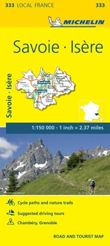
Isere, Savoie - Michelin Local Map 333 : Map
Publicado por Michelin Editions Des Voyages Apr 2016, 2016
ISBN 10: 2067210556ISBN 13: 9782067210554
Libro
Karte. Condición: Neu. Neuware - (Edition updated in 2018) The MICHELIN Isere, Savoie local map, scale 1/150,000 is the ideal companion to fully explore this local area close to the Alps and provides star-rated Michelin tourist itineraries and attractions, as well as impressive 3D relief mapping. MICHELIN local maps are perfect for cyclists and outdoor enthusiasts with over 20 leisure symbols, extensive coverage of cycling paths and nature trails. With MICHELIN local maps, find more than just your way!MICHELIN LOCAL MAPS provide detailed coverage of France are perfect for fully exploring these countries and are also ideal for cyclists.\* Impressive & realistic 3D relief mapping\* Michelin selected itineraries and must-sees of the area\* A clear and comprehensive key with 20 leisure symbols, as well as cycling paths and nature trails.\* Star rated tourist sights and attractions cross-referenced with the famous MICHELIN Green Guides.\* Plans of main cities and a comprehensive place name index 1 pp. Deutsch.
-
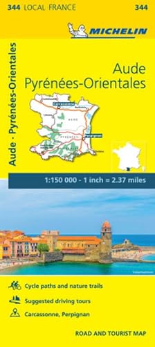
Aude, Pyrenees-Orientales - Michelin Local Map 344 : Map
Publicado por Michelin Editions Des Voyages Apr 2016, 2016
ISBN 10: 2067210785ISBN 13: 9782067210783
Libro
Karte. Condición: Neu. Neuware - (Edition updated in 2018) The MICHELIN Eure, Seine-Maritime local map, scale 1/150,000 is the ideal companion to fully explore these French local areas and provides star-rated Michelin tourist itineraries and attractions, as well as impressive 3D relief mapping. MICHELIN local maps are perfect for cyclists and outdoor enthusiasts with over 20 leisure symbols, extensive coverage of cycling paths and nature trails. With MICHELIN local maps, find more than just your way!MICHELIN LOCAL MAPS provide detailed coverage of France are perfect for fully exploring these countries and are also ideal for cyclists.\* Impressive & realistic 3D relief mapping\* Michelin selected itineraries and must-sees of the area\* A clear and comprehensive key with 20 leisure symbols, as well as cycling paths and nature trails.\* Star rated tourist sights and attractions cross-referenced with the famous MICHELIN Green Guides.\* Plans of main cities and a comprehensive place name index 1 pp. Deutsch.
-
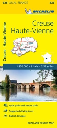
Creuse, Haute-Vienne - Michelin Local Map 325 : Map
Publicado por Michelin Editions Des Voyages Apr 2016, 2016
ISBN 10: 2067210394ISBN 13: 9782067210394
Libro
Karte. Condición: Neu. Neuware - (Edition updated in 2016) The MICHELIN Creuse, Haute-Vienne local map, scale 1/150,000 is the ideal companion to fully explore these French local areas and provides star-rated Michelin tourist itineraries and attractions, as well as impressive 3D relief mapping. MICHELIN local maps are perfect for cyclists and outdoor enthusiasts with over 20 leisure symbols, extensive coverage of cycling paths and nature trails. With MICHELIN local maps, find more than just your way!MICHELIN LOCAL MAPS provide detailed coverage of France are perfect for fully exploring these countries and are also ideal for cyclists.\* Impressive & realistic 3D relief mapping\* Michelin selected itineraries and must-sees of the area\* A clear and comprehensive key with 20 leisure symbols, as well as cycling paths and nature trails.\* Star rated tourist sights and attractions cross-referenced with the famous MICHELIN Green Guides.\* Plans of main cities and a comprehensive place name index 1 pp. Französisch.
-

Gers, Lot-et-Garonne - Michelin Local Map 336 : Map
Publicado por Michelin Editions Des Voyages Apr 2016, 2016
ISBN 10: 2067210610ISBN 13: 9782067210615
Libro
Karte. Condición: Neu. Neuware - (Edition updated in 2016) The MICHELIN Gers, Lot-et-Garonne local map, scale 1/150,000 is the ideal companion to fully explore this popular area of France and provides star-rated Michelin tourist itineraries and attractions, as well as impressive 3D relief mapping. MICHELIN local maps are perfect for cyclists and outdoor enthusiasts with over 20 leisure symbols, extensive coverage of cycling paths and nature trails. With MICHELIN local maps, find more than just your way!MICHELIN LOCAL MAPS provide detailed coverage of France are perfect for fully exploring these countries and are also ideal for cyclists.\* Impressive & realistic 3D relief mapping\* Michelin selected itineraries and must-sees of the area\* A clear and comprehensive key with 20 leisure symbols, as well as cycling paths and nature trails.\* Star rated tourist sights and attractions cross-referenced with the famous MICHELIN Green Guides.\* Plans of main cities and a comprehensive place name index 1 pp. Deutsch.
-
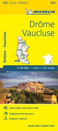
Drome, Vaucluse - Michelin Local Map 332 : Map
Publicado por Michelin Editions Des Voyages Apr 2016, 2016
ISBN 10: 2067210521ISBN 13: 9782067210523
Libro
Karte. Condición: Neu. Neuware - (Edition revised in 2020) The MICHELIN Drome, Vaucluse local map, scale 1/150,000 is the ideal companion to fully explore these Southern areas of France and provides star-rated Michelin tourist itineraries and attractions, as well as impressive 3D relief mapping. MICHELIN local maps are perfect for cyclists and outdoor enthusiasts with over 20 leisure symbols, extensive coverage of cycling paths and nature trails. With MICHELIN local maps, find more than just your way!MICHELIN LOCAL MAPS provide detailed coverage of France are perfect for fully exploring these countries and are also ideal for cyclists.\* Impressive & realistic 3D relief mapping\* Michelin selected itineraries and must-sees of the area\* A clear and comprehensive key with 20 leisure symbols, as well as cycling paths and nature trails.\* Star rated tourist sights and attractions cross-referenced with the famous MICHELIN Green Guides.\* Plans of main cities and a comprehensive place name index 1 pp. Deutsch.
-
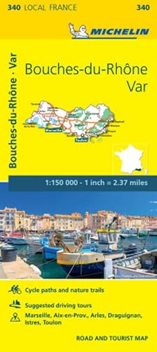
Bouches-du-Rhone, Var - Michelin Local Map 340 : Map
Publicado por Michelin Editions Des Voyages Apr 2016, 2016
ISBN 10: 2067210696ISBN 13: 9782067210691
Libro
Karte. Condición: Neu. Neuware - (Edition updated in 2018) The MICHELIN Bouches-du-Rhone, Var local map, scale 1 /150,000 is the ideal companion to fully explore southern France and provides star-rated Michelin tourist itineraries and attractions, as well as impressive 3D relief mapping. MICHELIN local maps are perfect for cyclists and outdoor enthusiasts with over 20 leisure symbols, extensive coverage of cycling paths and nature trails. With MICHELIN local maps, find more than just your way!MICHELIN LOCAL MAPS provide detailed coverage of France are perfect for fully exploring these countries and are also ideal for cyclists.\* Impressive & realistic 3D relief mapping\* Michelin selected itineraries and must-sees of the area\* A clear and comprehensive key with 20 leisure symbols, as well as cycling paths and nature trails.\* Star rated tourist sights and attractions cross-referenced with the famous MICHELIN Green Guides.\* Plans of main cities and a comprehensive place name index 1 pp. Deutsch.