
Importe total (1 artículo artículos):
Destino del pedido:

emmanuel publishers (29 resultados)
Comentarios
Ir a los resultados principales
Filtros de búsqueda
Tipo de artículo
- Todos los tipos de productos
- Libros (29)
- Revistas y publicaciones (No hay ningún otro resultado que coincida con este filtro.)
- Cómics (No hay ningún otro resultado que coincida con este filtro.)
- Partituras (No hay ningún otro resultado que coincida con este filtro.)
- Arte, grabados y pósters (No hay ningún otro resultado que coincida con este filtro.)
- Fotografías (No hay ningún otro resultado que coincida con este filtro.)
- Mapas (No hay ningún otro resultado que coincida con este filtro.)
- Manuscritos y coleccionismo de papel (No hay ningún otro resultado que coincida con este filtro.)
Encuadernación
Más atributos
- Primera edición (2)
- Firmado (No hay ningún otro resultado que coincida con este filtro.)
- Sobrecubierta (No hay ningún otro resultado que coincida con este filtro.)
- Con imágenes (9)
- No impresión bajo demanda (29)
Gastos de envío gratis
- Envío gratis a Espańa (No hay ningún otro resultado que coincida con este filtro.)
Valoración de los vendedores
-

Heavenly Food From On High
Publicado por Emmanuel Episcopal Church / Cookbook Publishers, Alexandria, Virginia / Lenexa, KS, 1983
Librería: Bookfeathers, LLC, Lewisburg, PA, Estados Unidos de America
Calificación del vendedor: 5 de 5 estrellas

Soft cover. Condición: Near Fine. Not ex-lib. Comb-spiralbound with illustrated white card covers, 8vo. 154pp. Index. NF. Occasional mild scuffing to overall clean, bright wraps; binding strong and square with no torn holes; pages cleanand unmarked.
-

Law in a Flash Civil Procedure Part I
Publicado por Emmanuel Aspen Publishers, 2011
Librería: Omaha Library Friends, Omaha, NE, Estados Unidos de America
Calificación del vendedor: 4 de 5 estrellas

Flash Cards. Condición: Fair. Three packages of flash cards are unopened. There are random cards from the other packets, but there appears some cards are Three packages of flash cards are unopened. Two packs have been opened and there are missing cards. Book was donated to Friends of Omaha Public Library.missing.
-

YHWH Exists
Publicado por Emmanuel Publishers, 2015
ISBN 10: 0975337505 ISBN 13: 9780975337509
Librería: GF Books, Inc., Hawthorne, CA, Estados Unidos de America
Calificación del vendedor: 5 de 5 estrellas
Condición: Good. Book is in Used-Good condition. Pages and cover are clean and intact. Used items may not include supplementary materials such as CDs or access codes. May show signs of minor shelf wear and contain limited notes and highlighting. 3.75.
Más opciones de compra de otros vendedores en IberLibro
Nuevo desde EUR 46,51
Usado desde EUR 46,08
Encuentre también Tapa dura Original o primera edición
-
THE COINAGE OF THE KNIGHTS IN MALTA. [In Two Volumes]. (Volume I. Text; Volume II. Plates)
Publicado por Malta: Emmanuel Said Publishers, 1977., 1977
Librería: Minster Gate Bookshop (est. 1970), YORK, Reino Unido
Miembro de asociación: PBFA
Calificación del vendedor: 5 de 5 estrellas
Two volumes, 4to., pp.(x),219;199 (90 b/w plates + Index), red faux-leather, gilt, with Maltese cross in white; discolouration from binder?s glue to margins of paste-down endpapers, otherwise a fine, fresh set, in plain cream paper protective dust-jackets, which have a little light surface soil/marking.
-
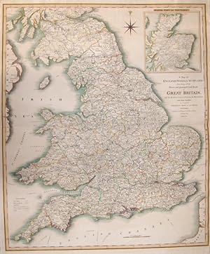
A Map of England, Wales + Scotland, describing all the Direct and principal Cross Roads in Great Britain, with the Distances measured between the.
Publicado por Artist: Faden William ( - 1836 ) London ; issued in: Wales; - William Faden (1749 ? 1836) was an English cartographer and a publisher of maps He was the royal geographer to King George III He replaced Thomas Jeffreys in that roleThe title of -geographer to the king- was given to various people in the 18th century including John Senex Herman Moll Emmanuel Bowen and Thomas Jeffreys All of these men including William Faden were engravers and publishers not scholars or academics Their part was to publish and supply maps to the crown and parliament William Faden printed the North American Atlas in 1777 and "it became the most important atlas chronicling the Revolution's battles" There were 29 maps in the atlas and they included detailed battle m, 1749
Librería: Antique Sommer& Sapunaru KG, München, Alemania
Miembro de asociación: ILAB VDA
Calificación del vendedor: 4 de 5 estrellas
Technic: Steel engraving, colorit: original colored, condition: Perfect condition, size (in cm): 71,5 x 60; - Map depicts Englan, Wales and Scottland with all the mainstreets and major cities. With a decorativie wind rose and on an inset map Scottland.; History: The Romans settled for the first time under the leadership of Caesar 55 and 54 BC. BC in England, but initially not as a conqueror. It was not until almost a century later that the Romans occupied England. Scottish ethnic groups repeatedly penetrated the power vacuum that emerged after the Roman withdrawal around 410 AD. Subsequently, groups of Anglers, Jutters and Saxons immigrated. This was the beginning of the early Middle Ages in Britain. The Danish Vikings finally sailed to England in the late 8th century. At first, they only carried out raids, but later they established themselves, asked for tribute payments and built their own villages. Wilhelm's victory in the High Middle Ages led to the introduction of the Normans' effective armrest system. A small Norman upper class almost completely replaced the established nobility. In the period from the middle of the 10th to the middle of the 14th century, the population tripled, and agriculture was intensified with the introduction of three-field farming and land reclamation. However, self-sufficiency with food only succeeded in climatically favorable and politically stable times. The Hundred Years War broke out in the late Middle Ages, the deposition of Richard II by later Henry IV and the failures in the Hundred Years War were the reasons for the outbreak of the subsequent Rose Wars. During the Tudor period, the Renaissance of England peaked through Italian courtiers who reintroduced the artistic, educational, and scientific debate from antiquity. England began to develop naval skills, and exploration of the West and Europe intensified. Henry VIII broke out of communion with the Catholic Church in connection with his divorce under the Acts of Supremacy of 1534, which proclaimed the monarch head of the Church of England. Unlike much of European Protestantism, the roots of the split were political rather than theological. There were internal religious conflicts during the reign of Henry's daughters Mary I and Elizabeth I. The former brought the country back to Catholicism, while the latter abandoned it and vigorously maintained the predominance of Anglicanism. The Elizabethan era began with Elizabeth I's accession to the throne in 1588. The new, Protestant queen was enthusiastically received by the people. From the beginning of her reign, a possible marriage of the queen was the dominant issue. Parliaments repeatedly asked them to obtain a male heir to the throne. She was responsible for the implementation of the Reformation, but also for the poorer relations with Spain.
-

Eastern Hemisphere
Publicado por Artist: Faden William ( - 1836 ) London ; issued in: London; - William Faden (1749 ? 1836) was an English cartographer and a publisher of maps He was the royal geographer to King George III He replaced Thomas Jeffreys in that roleThe title of -geographer to the king- was given to various people in the 18th century including John Senex Herman Moll Emmanuel Bowen and Thomas Jeffreys All of these men including William Faden were engravers and publishers not scholars or academics Their part was to publish and supply maps to the crown and parliament William Faden printed the North American Atlas in 1777 and "it became the most important atlas chronicling the Revolution's battles" There were 29 maps in the atlas and they included detailed battle, 1749
Librería: Antique Sommer& Sapunaru KG, München, Alemania
Miembro de asociación: ILAB VDA
Calificación del vendedor: 4 de 5 estrellas
Technic: Copper print, colorit: original colored, condition: Perfect condition, size (in cm): 58,5 x 57 cm; - Map shows the eastern hemisphere with Europe, Africa, Asia, Southeast Asia and Australia.; History: Popular science refers to the period from about the 15th to the 18th centuries. The era is considered to be in the early modern period and is primarily concerned with the knowledge of seafarers and explorers. The idea of the age of discoveries is shaped by seafaring and discoveries overseas. In terms of content, however, it also includes astronomy, which is associated with the names of Tycho Brahe, Nikolaus Kopernikus, Isaac Newton and Johannes Kepler, among others. Giordano Bruno and Galileo Galilei also belong to this group. Not only the seafarers with their discoveries, but also they brought about changes in the world view. Some motifs were religious, e.g. B. that Christianity should be spread in the New World (missionary). The great European powers also expected an expansion of their political sphere of influence. This is evident in the overseas colonies, including the Spaniards, Portuguese, English, Dutch and French. The Tordesillas Treaty of 1494 is an example of this. It regulated the distribution of the discovered countries between Portugal and Spain. Global exploration began with the Portuguese discoveries of the Atlantic archipelagos of Madeira and the Azores in 1419 and 1427, the African coast after 1434, and the sea route to India in 1498; and from the Crown of Castile (Spain) the transatlantic trips of Christopher Columbus to America between 1492 and 1502 and the first world tour in the years 1519?1522. These discoveries led to numerous naval expeditions across the Atlantic, Indian and Pacific Oceans, and land expeditions in America, Asia, Africa, and Australia that continued into the late 19th century, followed by exploration of the polar regions in the 20th century. European overseas exploration led to the rise of world trade and the European colonial empires, with contact between the Old World (Europe, Asia and Africa) and the New World (America and Australia) creating Colombian exchange, a wide range of plant transfers, animals, and food , human populations (including slaves), communicable diseases and culture between the Eastern and Western Hemisphere. The age of discovery and later exploration of Europe made it possible to map the world, which led to a new worldview and distant civilizations, but also to the spread of diseases that decimated populations that were not previously in contact with Eurasia and Africa, and to enslavement , Exploitation, military conquest and economic dominance of Europe and its colonies over indigenous people. It also allowed the expansion of Christianity.
-
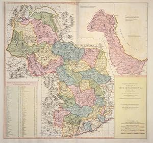
Carte Géneral de Etats du Roi de Sardaigne
Publicado por Artist: Faden William ( - 1836 ) London ; issued in: London; - William Faden (1749 ? 1836) was an English cartographer and a publisher of maps He was the royal geographer to King George III He replaced Thomas Jeffreys in that roleThe title of -geographer to the king- was given to various people in the 18th century including John Senex Herman Moll Emmanuel Bowen and Thomas Jeffreys All of these men including William Faden were engravers and publishers not scholars or academics Their part was to publish and supply maps to the crown and parliament William Faden printed the North American Atlas in 1777 and "it became the most important atlas chronicling the Revolution's battles" There were 29 maps in the atlas and they included detailed battle, 1749
Librería: Antique Sommer& Sapunaru KG, München, Alemania
Miembro de asociación: ILAB VDA
Calificación del vendedor: 4 de 5 estrellas
Technic: Copper print, colorit: colored, condition: Very good, size (in cm): 51 x 54; - map of the properties of the King of Sardinia, south of Lake Geneva.; History: In ancient times, in northern Italy, unlike in southern Italy, there was hardly any Greek colonization. For the Roman Empire, Northern Italy was initially Gallia cisalpina. Since the Middle Ages, northern Italy has been characterized by remarkable trading cities, which, starting from the Veronese Confederation, united in the Lombardenbund against Emperor Barbarossa. At that time, some basics of business administration and banking, such as double-entry bookkeeping, were created in northern Italy. In pre-Roman centuries it was inhabited by different peoples among whom the Ligures, the ancient Veneti, who prospered through their trade in amber and breeding of horses, the Etruscans, who colonized Northern Italy from Tuscany, founded the city of Bologna and spread the use of writing; later, starting from the 5th century BC, the area was invaded by Celtic ? Gallic tribes. These people founded several cities like Turin and Milan and extended their rule from the Alps to the Adriatic Sea. Their development was halted by the Roman expansion in the Po Valley from the 3rd century BC onwards. After centuries of struggle, in 194 BC the entire area of what is now Northern Italy became a Roman province with the name of Gallia Cisalpina ("Gaul on the inner side (with respect to Rome) of the Alps"). The Roman culture and language overwhelmed the former civilization in the following years, and Northern Italy became one of the most developed and rich areas of the western half of the empire with the construction of a wide array of roads and the development of agriculture and trade. After the fall of the Western Empire, Northern Italy suffered heavily from destruction brought about by migration from Germanic peoples and from the Gothic War. In the 10th century Northern Italy was formally under the rule of the Holy Roman Empire but was in fact divided in a multiplicity of small, autonomous city-states, the medieval communes and maritime republic. The 11th century marked a significant boom in Northern Italy's economy, due to improved trading and agricultural innovations, culture flourished as well with many universities founded, among them the University of Bologna, the oldest university in Europe. In the end a balance of power was reached in 1454 with the Peace of Lodi and Northern Italy ended up divided between a small number of regional states, the most powerful were the Duchies of Savoy, Milan, Mantua, Ferrara and the Republics of Genoa and Venice, which had begun to extend its influence in the mainland from the 14th century onwards. In the 15th century Northern Italy became one of the centres of the Renaissance whose culture and works of art were highly regarded. After the French Revolution in the late 18th century Northern Italy was conquered by the French armies, many client republics were created by Napoleon and in 1805 a new Kingdom of Italy, made of all of Northern Italy but Piedmont that was annexed to France, was established with Milan as capital and Napoleon as head of state. In the congress of Vienna, the Kingdom of Sardinia was restored, and furthermore enlarged by annexing the Republic of Genoa to strengthen it as a barrier against France. The rest of Northern Italy was under Austrian rule, either direct like in the Lombardo-Venetian Kingdom or indirect like in the Duchies of Parma and Modena. Bologna and Romagna were given to the Papal State.
-
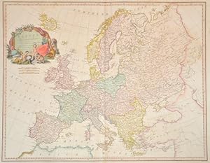
Europe, Exhibiting its principal states.
Publicado por Artist: Faden William ( - 1836 ) London ; issued in: London; - William Faden (1749 ? 1836) was an English cartographer and a publisher of maps He was the royal geographer to King George III He replaced Thomas Jeffreys in that roleThe title of -geographer to the king- was given to various people in the 18th century including John Senex Herman Moll Emmanuel Bowen and Thomas Jeffreys All of these men including William Faden were engravers and publishers not scholars or academics Their part was to publish and supply maps to the crown and parliament William Faden printed the North American Atlas in 1777 and "it became the most important atlas chronicling the Revolution's battles" There were 29 maps in the atlas and they included detailed battle, 1749
Librería: Antique Sommer& Sapunaru KG, München, Alemania
Miembro de asociación: ILAB VDA
Calificación del vendedor: 4 de 5 estrellas
Technic: Copper print, colorit: original colored, condition: Some restoration at centerfold, size (in cm): 51,5 x 66; - Map shows total Europe with the formaer frontiers; History: Especially the Greek culture, the Roman Empire and Christianity left their mark until today. In ancient times, the Roman Empire at the time of Augustus united for the first time the entire southern Europe together with the other coastal countries of the Mediterranean in one great empire. In the Roman Empire, the new religion of Christianity was able to spread rapidly. In the early Middle Ages, the Paderborn Epic declared the ruler of the Frankish Empire, Charlemagne, to be the "Father of Europe." The Middle Ages were marked, among other things, by competition between the new Roman emperor in the West and the Byzantine emperor in Constantinople, in the East, to whose two spheres of influence the later deepened division into a Western and Eastern Europe can be traced. Since the 15th century, European nations (especially Spain, Portugal, Russia, the Netherlands, France, and the United Kingdom of Great Britain and Northern Ireland) built colonial empires with large possessions on all other continents. Europe is the continent that has influenced the other continents the most, for example, through Christian missionary work, colonies, slave trade, exchange of goods and culture. n the 18th century, the Enlightenment movement set new directions and demanded tolerance, respect for human dignity, equality and freedom. In France, the French Revolution brought the bourgeoisie to power in 1789. In the early 19th century, half of Europe had to conform to the will of Napoleon, the French emperor who came to power after the revolutionary period, until he suffered a fiasco in Russia in 1812. The conservative victorious powers then tried to restore pre-revolutionary conditions at the Congress of Vienna, which succeeded only temporarily. Industrialization began in parts of Europe in the 18th century and rapidly changed the everyday lives of broad sections of the population.
-

Nouvelle Carte de la Suisse dans laquelle sont exactement distingues Les Treize Cantons,.
Publicado por Artist: Faden William ( - 1836 ) London ; issued in: London; - William Faden (1749 ? 1836) was an English cartographer and a publisher of maps He was the royal geographer to King George III He replaced Thomas Jeffreys in that roleThe title of -geographer to the king- was given to various people in the 18th century including John Senex Herman Moll Emmanuel Bowen and Thomas Jeffreys All of these men including William Faden were engravers and publishers not scholars or academics Their part was to publish and supply maps to the crown and parliament William Faden printed the North American Atlas in 1777 and "it became the most important atlas chronicling the Revolution's battles" There were 29 maps in the atlas and they included detailed battle, 1749
Librería: Antique Sommer& Sapunaru KG, München, Alemania
Miembro de asociación: ILAB VDA
Calificación del vendedor: 4 de 5 estrellas
Technic: Copper print, colorit: original colored, condition: Some folds, size (in cm): 63 x 85; - Decorative map of Swizzerland with two cartouches, a view and hight descriptuion of the mountains in Swizerland.; History: Since 1848, the Swiss Confederation has been a federal state of relatively autonomous cantons, some of which have a history of confederacy that goes back more than 700 years, putting them among the world's oldest surviving republics. The early history of the region is tied to that of Alpine culture. Switzerland was inhabited by Gauls and Raetians, and it came under Roman rule in the 1st century BC. Gallo-Roman culture was amalgamated with Germanic influence during Late Antiquity, with the eastern part of Switzerland becoming Alemannic territory. The area of Switzerland was incorporated into the Frankish Empire in the 6th century. In the high medieval period, the eastern part became part of the Duchy of Swabia within the Holy Roman Empire while the western part was part of Burgundy.
-
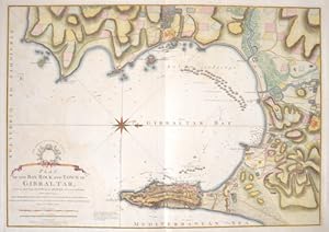
Plan of the Bay, Rock and Town of Gibraltar, from an Actual Survey by an Officer who was at Gibraltar from 1769 to 1775.
Publicado por Artist: Faden William ( - 1836 ) London ; issued in: London; - William Faden (1749 ? 1836) was an English cartographer and a publisher of maps He was the royal geographer to King George III He replaced Thomas Jeffreys in that roleThe title of -geographer to the king- was given to various people in the 18th century including John Senex Herman Moll Emmanuel Bowen and Thomas Jeffreys All of these men including William Faden were engravers and publishers not scholars or academics Their part was to publish and supply maps to the crown and parliament William Faden printed the North American Atlas in 1777 and "it became the most important atlas chronicling the Revolution's battles" There were 29 maps in the atlas and they included detailed battle, 1749
Librería: Antique Sommer& Sapunaru KG, München, Alemania
Miembro de asociación: ILAB VDA
Calificación del vendedor: 4 de 5 estrellas
Technic: Copper print, colorit: gouache, condition: Perfect condition, size (in cm): 51,5 x 73 cm; - Map shows the Bay of Gibraltar, the city of Gibraltar and the coast with upstream sailing ships and a wind rose.; History: Gibraltar is a British Overseas Territory located on the southern end of the Iberian Peninsula. In 1704, during the War of the Spanish Succession, a combined Anglo-Dutch fleet, representing the Grand Alliance, captured the town of Gibraltar on behalf of the Archduke Charles of Austria in his campaign to become King of Spain. The occupation of the town by Alliance forces caused the exodus of the population to the surrounding area of the Campo de Gibraltar.As the Alliance's campaign faltered, the 1713 Treaty of Utrecht was negotiated and ceded control of Gibraltar to Britain to secure Britain's withdrawal from the war. Unsuccessful attempts by Spanish monarchs to regain Gibraltar were made with the siege of 1727 and again with the Great Siege of Gibraltar (1779 to 1783), during the American War of Independence. Gibraltar became a key base for the Royal Navy and played an important role prior to the Battle of Trafalgar.
