
Importe total (1 artículo artículos):
Destino del pedido:

cosmographia books (139 resultados)
Comentarios
Ir a los resultados principales
Filtros de búsqueda
Tipo de artículo
- Todos los tipos de productos
- Libros (139)
- Revistas y publicaciones (No hay ningún otro resultado que coincida con este filtro.)
- Cómics (No hay ningún otro resultado que coincida con este filtro.)
- Partituras (No hay ningún otro resultado que coincida con este filtro.)
- Arte, grabados y pósters (No hay ningún otro resultado que coincida con este filtro.)
- Fotografías (No hay ningún otro resultado que coincida con este filtro.)
- Mapas (No hay ningún otro resultado que coincida con este filtro.)
- Manuscritos y coleccionismo de papel (No hay ningún otro resultado que coincida con este filtro.)
Encuadernación
Más atributos
Gastos de envío gratis
- Envío gratis a Espańa (No hay ningún otro resultado que coincida con este filtro.)
Valoración de los vendedores
-

Island Chains
Publicado por Cosmographia Books, 2018
ISBN 10: 173226905X ISBN 13: 9781732269057
Librería: Wonder Book, Frederick, MD, Estados Unidos de America
Miembro de asociación: ABAA ILAB
Calificación del vendedor: 5 de 5 estrellas

Condición: Very Good. Very Good condition. A copy that may have a few cosmetic defects. May also contain a few markings such as an owner's name, short gifter's inscription or light stamp.
Más opciones de compra de otros vendedores en IberLibro
Nuevo desde EUR 16,73
Usado desde EUR 5,15
Encuentre también Tapa blanda
-

Fair Lady: Memoirs of a County Fair Manager
Publicado por Cosmographia Books, 2021
ISBN 10: 0578916924 ISBN 13: 9780578916927
Librería: ZBK Books, Carlstadt, NJ, Estados Unidos de America
Calificación del vendedor: 5 de 5 estrellas
Condición: very_good. Used book in very good and clean conditions. Minor cosmetic defects may be present. Pages and cover intact. May include library marks, notes marks and highlighting. Fast Shipping.
Más opciones de compra de otros vendedores en IberLibro
Nuevo desde EUR 16,59
Usado desde EUR 6,13
Encuentre también Tapa blanda
-

The Spirit It Travels: An Anthology of Transcendent Poetry
Publicado por Cosmographia Books, 2019
ISBN 10: 1732269092 ISBN 13: 9781732269095
Librería: St Vincent de Paul of Lane County, Eugene, OR, Estados Unidos de America
Calificación del vendedor: 5 de 5 estrellas
Condición: Good. paperback This item shows wear from consistent use but remains in good readable condition. It may have marks on or in it, and may show other signs of previous use or shelf wear. May have minor creases or signs of wear on dust jacket. Packed with care, shipped promptly.
Más opciones de compra de otros vendedores en IberLibro
Nuevo desde EUR 18,32
Usado desde EUR 7,24
Encuentre también Tapa dura Tapa blanda Original o primera edición
-

Trees of Life and Shade
Publicado por Cosmographia Books January 2019, 2019
ISBN 10: 1732269076 ISBN 13: 9781732269071
Librería: Firefly Bookstore, Kutztown, PA, Estados Unidos de America
Calificación del vendedor: 5 de 5 estrellas
Trade Paperback. Condición: Used Good. Light wear to cover, slightly bumped corners, pages have some markings or underlining. Firefly sells new and used books through our store front. We try to add a detailed description to as many titles as possible. If you have questions regarding this title, please contact us. Photos available on request.
Más opciones de compra de otros vendedores en IberLibro
Nuevo desde EUR 29,61
Usado desde EUR 11,79
Encuentre también Tapa blanda Ejemplar firmado
-

The Umbilical Universe
Publicado por Cosmographia Books August 2018, 2018
ISBN 10: 1732269025 ISBN 13: 9781732269026
Librería: Firefly Bookstore, Kutztown, PA, Estados Unidos de America
Calificación del vendedor: 5 de 5 estrellas
Trade Paperback. Condición: Used Good. Light wear to cover, slightly bumped corners, a few pages have some markings or underlining. Firefly sells new and used books through our store front. We try to add a detailed description to as many titles as possible. If you have questions regarding this title, please contact us. Photos available on request.
Más opciones de compra de otros vendedores en IberLibro
Nuevo desde EUR 15,94
Usado desde EUR 12,71
Encuentre también Tapa blanda
-

Blissful and Other Stories
Publicado por Cosmographia Books, Rochester, NY, 2017
ISBN 10: 0692944265 ISBN 13: 9780692944264
Librería: Abacus Bookshop, Pittsford, NY, Estados Unidos de America
Calificación del vendedor: 5 de 5 estrellas
Original o primera edición
softcover. Condición: Fine copy. Ill. by Fawndolyn Valentine Ilustrador. 1st edition. 8vo, 153 pp.
-

There Is Only Lampyridae
Publicado por Cosmographia Books, 2018
ISBN 10: 1732269017 ISBN 13: 9781732269019
Librería: ThriftBooks-Atlanta, AUSTELL, GA, Estados Unidos de America
Calificación del vendedor: 5 de 5 estrellas
Paperback. Condición: Good. No Jacket. Pages can have notes/highlighting. Spine may show signs of wear. ~ ThriftBooks: Read More, Spend Less 0.5.
Más opciones de compra de otros vendedores en IberLibro
Nuevo desde EUR 51,13
Usado desde EUR 14,80
Encuentre también Tapa blanda
-

Dimitri House Stories
Publicado por Cosmographia Books, 2015
ISBN 10: 069253962X ISBN 13: 9780692539620
Librería: SecondSale, Montgomery, IL, Estados Unidos de America
Calificación del vendedor: 5 de 5 estrellas
Condición: Very Good. Item in very good condition! Textbooks may not include supplemental items i.e. CDs, access codes etc.
Más opciones de compra de otros vendedores en IberLibro
Nuevo desde EUR 15,22
Usado desde EUR 15,20
Encuentre también Tapa blanda
-

Salt Water
Publicado por Cosmographia Books, 2019
ISBN 10: 1732269084 ISBN 13: 9781732269088
Librería: Lucky's Textbooks, Dallas, TX, Estados Unidos de America
Calificación del vendedor: 5 de 5 estrellas
Condición: New.
Más opciones de compra de otros vendedores en IberLibro
Nuevo desde EUR 15,79
Encuentre también Tapa blanda
-

Poems for the Camel
Publicado por Cosmographia Books, 2018
ISBN 10: 1732269009 ISBN 13: 9781732269002
Librería: SecondSale, Montgomery, IL, Estados Unidos de America
Calificación del vendedor: 5 de 5 estrellas
Condición: Good. Item in good condition. Textbooks may not include supplemental items i.e. CDs, access codes etc.
Más opciones de compra de otros vendedores en IberLibro
Nuevo desde EUR 17,52
Usado desde EUR 16,68
Encuentre también Tapa blanda
-

Journeys with Fortune: A Tale of Other Lives
Publicado por Cosmographia Books, 2019
ISBN 10: 1732269068 ISBN 13: 9781732269064
Librería: GreatBookPrices, Columbia, MD, Estados Unidos de America
Calificación del vendedor: 5 de 5 estrellas
Condición: New.
Más opciones de compra de otros vendedores en IberLibro
Nuevo desde EUR 17,77
Usado desde EUR 17,83
Encuentre también Tapa blanda
-
![Imagen del vendedor de Letters To My Lover From Behind Asylum Walls by Sinclair, Robin [Paperback ] a la venta por booksXpress](https://pictures.abebooks.com/inventory/md/md31970544623.jpg)
Letters To My Lover From Behind Asylum Walls by Sinclair, Robin [Paperback ]
Publicado por Cosmographia Books, 2018
ISBN 10: 1732269033 ISBN 13: 9781732269033
Librería: booksXpress, Bayonne, NJ, Estados Unidos de America
Calificación del vendedor: 4 de 5 estrellas

Soft Cover. Condición: new.
Más opciones de compra de otros vendedores en IberLibro
Nuevo desde EUR 19,93
Encuentre también Tapa blanda
-
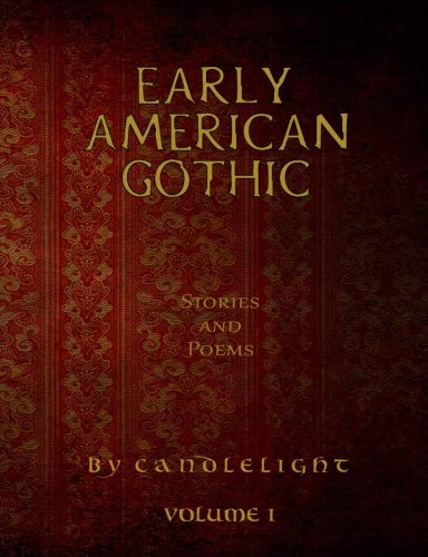
Early American Gothic Stories and Poems: Volume 1 (By Candlelight)
Publicado por Cosmographia Books, 2018
ISBN 10: 1732269041 ISBN 13: 9781732269040
Librería: Revaluation Books, Exeter, Reino Unido
Calificación del vendedor: 5 de 5 estrellas
Paperback. Condición: Brand New. 182 pages. 9.69x7.44x0.46 inches. In Stock.
-

Bohemiae nova descriptio tabula
Publicado por Artist: Ptolemy/Münster Sebastian Claudius ( - 1552 ) Basel ; issued in: Basle; - Sebastian Münster (1488 ? 1552) belongs tot he very important Comographers oft he Renaicance He issued his first famous Cosmographia in 1544 with 24 double paged maps with German description of the worldIt had numerous editions in different languages including Latin French Italian English and Czech The last German edition was published in 1628 long after his death The Cosmographia was one of the most successful and popular books of the 16th century It passed through 24 editions in 100 years This success was due to the notable woodcuts some by Hans Holbein the Younger Urs Graf Hans Rudolph Deutsch and David Kandel It was most important in reviving geography in, 1489
Librería: Antique Sommer& Sapunaru KG, München, Alemania
Miembro de asociación: ILAB VDA
Calificación del vendedor: 4 de 5 estrellas
Technic: Woodcut, colorit: original colored, condition: Very good, size (in cm): 27 x 35,5 cm; - Map shows the whole of Bohemia with its sites, rivers, mountains and forests in the Czech Republic. - additional information: From the famous Cosmographia, latin edition; History: Bohemia is the westernmost and largest historical region of the Czech lands in the present-day Czech Republic. In a broader meaning, Bohemia sometimes refers to the entire Czech territory, including Moravia and Czech Silesia, especially in a historical context, such as the Lands of the Bohemian Crown ruled by Bohemian kings. Bohemia was a duchy of Great Moravia, later an independent principality, a kingdom in the Holy Roman Empire, and subsequently a part of the Habsburg Monarchy and the Austrian Empire. After World War I and the establishment of an independent Czechoslovak state, Bohemia became a part of Czechoslovakia. Between 1938 and 1945, border regions with sizeable German-speaking minorities of all three Czech lands were joined to Nazi Germany as the Sudetenland.
-
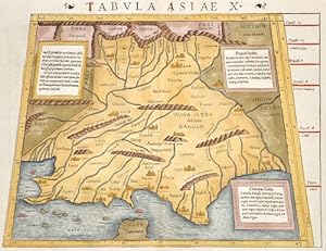
Tabula Asiae X
Publicado por Artist: Ptolemy/Münster Sebastian Claudius ( - 1552 ) Basel ; issued in: Basle; - Sebastian Münster (1488 ? 1552) belongs tot he very important Comographers oft he Renaicance He issued his first famous Cosmographia in 1544 with 24 double paged maps with German description of the worldIt had numerous editions in different languages including Latin French Italian English and Czech The last German edition was published in 1628 long after his death The Cosmographia was one of the most successful and popular books of the 16th century It passed through 24 editions in 100 years This success was due to the notable woodcuts some by Hans Holbein the Younger Urs Graf Hans Rudolph Deutsch and David Kandel It was most important in reviving geography in, 1489
Librería: Antique Sommer& Sapunaru KG, München, Alemania
Miembro de asociación: ILAB VDA
Calificación del vendedor: 4 de 5 estrellas
Technic: Woodcut, colorit: colored, condition: Some restoration at centerfold, size (in cm): 26 x 34,5; - Map shows India with the river Ganges, Irak, and Iran. Decorative ornamental title on reverse.; History: After the 10th century, Muslim Central Asian nomadic clans, using swift-horse cavalry and raising vast armies united by ethnicity and religion, repeatedly overran South Asia's north-western plains, leading eventually to the establishment of the Islamic Delhi Sultanate in 1206. The sultanate was to control much of North India and to make many forays into South India. Although at first disruptive for the Indian elites, the sultanate largely left its vast non-Muslim subject population to its own laws and customs. By repeatedly repulsing Mongol raiders in the 13th century, the sultanate saved India from the devastation visited on West and Central Asia, setting the scene for centuries of migration of fleeing soldiers, learned men, mystics, traders, artists, and artisans from that region into the subcontinent, thereby creating a syncretic Indo-Islamic culture in the north. The sultanate's raiding and weakening of the regional kingdoms of South India paved the way for the indigenous Vijayanagara Empire. Embracing a strong Shaivite tradition and building upon the military technology of the sultanate, the empire came to control much of peninsular India and was to influence South Indian society for long afterwards. n the early 16th century, northern India, then under mainly Muslim rulers fell again to the superior mobility and firepower of a new generation of Central Asian warriors. The resulting Mughal Empire did not stamp out the local societies it came to rule. Instead, it balanced and pacified them through new administrative practices and diverse and inclusive ruling elites, leading to more systematic, centralised, and uniform rule. Eschewing tribal bonds and Islamic identity, especially under Akbar, the Mughals united their far-flung realms through loyalty, expressed through a Persianised culture, to an emperor who had near-divine status. The Mughal state's economic policies, deriving most revenues from agriculture and mandating that taxes be paid in the well-regulated silver currency caused peasants and artisans to enter larger markets. Newly coherent social groups in northern and western India, such as the Marathas, the Rajputs, and the Sikhs, gained military and governing ambitions during Mughal rule, which, through collaboration or adversity, gave them both recognition and military experience. By the early 18th century, with the lines between commercial and political dominance being increasingly blurred, a number of European trading companies, including the English East India Company, had established coastal outposts. The East India Company's control of the seas, greater resources, and more advanced military training and technology led it to increasingly flex its military muscle and caused it to become attractive to a portion of the Indian elite; these factors were crucial in allowing the company to gain control over the Bengal region by 1765 and sideline the other European companies.
-
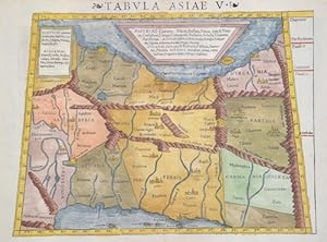
Tabula Asiae V
Publicado por Artist: Ptolemy/Münster Sebastian Claudius ( - 1552 ) Basel ; issued in: Basle; - Sebastian Münster (1488 ? 1552) belongs to the very important Comographers oft he Renaicance He issued his first famous Cosmographia in 1544 with 24 double paged maps with German description of the worldIt had numerous editions in different languages including Latin French Italian English and Czech The last German edition was published in 1628 long after his death The Cosmographia was one of the most successful and popular books of the 16th century It passed through 24 editions in 100 years This success was due to the notable woodcuts some by Hans Holbein the Younger Urs Graf Hans Rudolph Deutsch and David Kandel It was most important in reviving geography in, 1489
Librería: Antique Sommer& Sapunaru KG, München, Alemania
Miembro de asociación: ILAB VDA
Calificación del vendedor: 4 de 5 estrellas
Technic: Woodcut, colorit: original colored, condition: Perfect condition, size (in cm): 26,5 x 34 cm; - Trapezoidal map shows Asia Minor with Persia, the area of __the Tigris and Euphrates rivers, the former Mesopotamia.; History: The ancient empire of the Persians is referred to as the Persian Empire or Persian Empire, which at times extended from Thrace to north-west India and Egypt. It existed in different dimensions from about 550 to 330 BC. AD (Old Persian Empire of the Achaemenids) and from approx. 224 to 651 AD (New Persian Empire of the Sassanids). This name is a foreign name, as the native name has always been a variant of the term Iran. By the 1500s, Ismail I of Ardabil established the Safavid Empire,with his capital at Tabriz. Beginning with Azerbaijan, he subsequently extended his authority over all of the Iranian territories, and established an intermittent Iranian hegemony over the vast relative regions, reasserting the Iranian identity within large parts of Greater Iran. Iran was predominantly Sunni, but Ismail instigated a forced conversion to the Shia branch of Islam, spreading throughout the Safavid territories in the Caucasus, Iran, Anatolia, and Mesopotamia. As a result, modern-day Iran is the only official Shia nation of the world, with it holding an absolute majority in Iran and the Republic of Azerbaijan, having there the first and the second highest number of Shia inhabitants by population percentage in the world. Meanwhile, the centuries-long geopolitical and ideological rivalry between Safavid Iran and the neighboring Ottoman Empire led to numerous Ottoman?Iranian wars. The Safavid era peaked in the reign of Abbas I (1587?1629), surpassing their Turkish archrivals in strength, and making Iran a leading science and art hub in western Eurasia. The Safavid era saw the start of mass integration from Caucasian populations into new layers of the society of Iran, as well as mass resettlement of them within the heartlands of Iran, playing a pivotal role in the history of Iran for centuries onwards. Following a gradual decline in the late 1600s and the early 1700s, which was caused by internal conflicts, the continuous wars with the Ottomans, and the foreign interference (most notably the Russian interference), the Safavid rule was ended by the Pashtun rebels who besieged Isfahan and defeated Sultan Husayn in 1722. In 1729, Nader Shah, a chieftain and military genius from Khorasan, successfully drove out and conquered the Pashtun invaders. He subsequently took back the annexed Caucasian territories which were divided among the Ottoman and Russian authorities by the ongoing chaos in Iran. During the reign of Nader Shah, Iran reached its greatest extent since the Sasanian Empire, reestablishing the Iranian hegemony all over the Caucasus, as well as other major parts of the west and central Asia, and briefly possessing what was arguably the most powerful empire at the time.
-
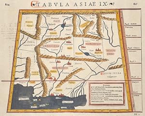
Tabula Asiae IX
Publicado por Artist: Ptolemy/Münster Sebastian Claudius ( - 1552 ) Basel ; issued in: Basle; - Sebastian Münster (1488 ? 1552) belongs tot he very important Comographers oft he Renaicance He issued his first famous Cosmographia in 1544 with 24 double paged maps with German description of the worldIt had numerous editions in different languages including Latin French Italian English and Czech The last German edition was published in 1628 long after his death The Cosmographia was one of the most successful and popular books of the 16th century It passed through 24 editions in 100 years This success was due to the notable woodcuts some by Hans Holbein the Younger Urs Graf Hans Rudolph Deutsch and David Kandel It was most important in reviving geography in, 1489
Librería: Antique Sommer& Sapunaru KG, München, Alemania
Miembro de asociación: ILAB VDA
Calificación del vendedor: 4 de 5 estrellas
Technic: Woodcut, colorit: original colored, condition: Very good, size (in cm): 26 x 34 cm; - Map shows Pakistan with the river Indus, Afgansitan and partly Iran.; History: Around the middle of the 2nd millennium BC The Aryans from Central Asia invaded Pakistan. They shaped Vedic culture and Hinduism. Today's Pakistani territory already came into contact with Islam in the early 8th century when the Arabs conquered the Indus Valley under Muhammad ibn al-Qasim in 712. For centuries the border between the Islamic world and the Indian culture was east of the Indus. The Punjab initially remained outside the Muslim sphere of influence. It was only around 1000 that the Turkish Ghaznavid dynasty extended its empire to the whole of Pakistan and parts of northern India. Until the beginning of the 19th century, Pakistan was part of various Islamic empires, including those of the Persian Ghurids (12th and 13th centuries), the North Indian Delhi Sultans (13th and 14th centuries) and Mughals (16th to 18th centuries) ) and the Afghan Durrani dynasty (18th and 19th centuries).
-

Helvetiae Tabula.
Publicado por Artist: Ptolemy/Münster Sebastian Claudius ( - 1552 ) Basel ; issued in: Basle; - Sebastian Münster (1488 ? 1552) belongs tot he very important Comographers oft he Renaicance He issued his first famous Cosmographia in 1544 with 24 double paged maps with German description of the worldIt had numerous editions in different languages including Latin French Italian English and Czech The last German edition was published in 1628 long after his death The Cosmographia was one of the most successful and popular books of the 16th century It passed through 24 editions in 100 years This success was due to the notable woodcuts some by Hans Holbein the Younger Urs Graf Hans Rudolph Deutsch and David Kandel It was most important in reviving geography in, 1489
Librería: Antique Sommer& Sapunaru KG, München, Alemania
Miembro de asociación: ILAB VDA
Calificación del vendedor: 4 de 5 estrellas
Technic: Woodcut, colorit: original colored, condition: Perfect condition, size (in cm): 27 x 34,5 cm; - Map shows total Swizzerland and its borgering countries, Germany with the Elsass. - additional information: From the famous Cosmographia, latin edition; History: Since 1848, the Swiss Confederation has been a federal state of relatively autonomous cantons, some of which have a history of confederacy that goes back more than 700 years, putting them among the world's oldest surviving republics. The early history of the region is tied to that of Alpine culture. Switzerland was inhabited by Gauls and Raetians, and it came under Roman rule in the 1st century BC. Gallo-Roman culture was amalgamated with Germanic influence during Late Antiquity, with the eastern part of Switzerland becoming Alemannic territory. The area of Switzerland was incorporated into the Frankish Empire in the 6th century. In the high medieval period, the eastern part became part of the Duchy of Swabia within the Holy Roman Empire while the western part was part of Burgundy.
-
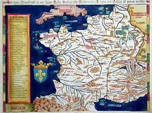
Das ganz Frankreich so vor zeiten Galia Narbonensis, Eugdonensis/Belgica und Celtica ist genent worden
Publicado por Artist: Ptolemy/Münster Sebastian Claudius ( - 1552 ) Basel ; issued in: ; - Sebastian Münster (1488 ? 1552) belongs tot he very important Comographers oft he Renaicance He issued his first famous Cosmographia in 1544 with 24 double paged maps with German description of the worldIt had numerous editions in different languages including Latin French Italian English and Czech The last German edition was published in 1628 long after his death The Cosmographia was one of the most successful and popular books of the 16th century It passed through 24 editions in 100 years This success was due to the notable woodcuts some by Hans Holbein the Younger Urs Graf Hans Rudolph Deutsch and David Kandel It was most important in reviving geography in 16th-, 1489
Librería: Antique Sommer& Sapunaru KG, München, Alemania
Miembro de asociación: ILAB VDA
Calificación del vendedor: 4 de 5 estrellas
Technic: Woodcut, colorit: original colored, condition: Very good, size (in cm): 26 x 34; - Map shows total France; History: It is estimated that today's France was settled about 48,000 years ago. Important rock paintings from the Paleolithic period have been preserved in the Lascaux cave From 600 BC Chr. Phoenician and Greek traders founded bases on the Mediterranean coast, while Celts settled from the northwest the country that was later called by the Romans as Gaul. The French Middle Ages were marked by the rise of kingship in the constant struggle against the independence of the nobility and the secular violence of the monasteries and religious orders. Starting from today's Île-de-France, the Capetinians enforced the idea of a unitary state, which was underpinned by participation in various crusades. The Normans invaded Normandy repeatedly, hence its name; in 1066 they conquered England. A long series of armed conflicts with England began under Louis VII after Ludwig's divorced wife Eleonore von Poitou and Aquitaine married Heinrich Plantagenet in 1152 and thus about half of France's territory fell to England. Philip II August, together with the Hohenstaufen family, largely displaced England from France until 1299; the English king Henry III Ludwig IX. recognize as suzerain. From 1226 France became an inheritance monarchy; in 1250 Ludwig IX was one of the most powerful rulers in the West. In the 17th and 18th centuries, France held European leadership and supremacy. The political and cultural charisma was significant: The court of Louis XIV became the model for absolutist states throughout Europe and the French Revolution with the declaration of human and civil rights, together with occupations by Napoleon Bonaparte, started in many countries the time and again Setbacks interrupted development towards democracy.
-
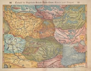
Landtafel des Ungerlands/Polands/Reussen/Littaw/Walachei und Bulgarei
Publicado por Artist: Ptolemy/Münster Sebastian Claudius ( - 1552 ) Basel ; issued in: Basle; - Sebastian Münster (1488 ? 1552) belongs tot he very important Comographers oft he Renaicance He issued his first famous Cosmographia in 1544 with 24 double paged maps with German description of the worldIt had numerous editions in different languages including Latin French Italian English and Czech The last German edition was published in 1628 long after his death The Cosmographia was one of the most successful and popular books of the 16th century It passed through 24 editions in 100 years This success was due to the notable woodcuts some by Hans Holbein the Younger Urs Graf Hans Rudolph Deutsch and David Kandel It was most important in reviving geography in, 1489
Librería: Antique Sommer& Sapunaru KG, München, Alemania
Miembro de asociación: ILAB VDA
Calificación del vendedor: 4 de 5 estrellas
Technic: Woodcut, colorit: original colored, condition: Very good, size (in cm): 26 x 34; - Map shows Hungaria with Craotien, Poland, Lithuania, Moldavia and partly Rumania and Bulgaria.; History: In the historical sense, Eastern Europe refers to Ukraine, the European part of Russia, Belarus and the Republic of Moldova. Occasionally, the Caucasian countries of Georgia, Armenia and, conditionally, Azerbaijan are also seen as part of Eastern Europe. By Christian Giordano and other scholars, one of the six historical regions of Europe is called "Eastern Europe." The Eastern European countries are historically and culturally largely influenced by the Orthodox Church (Islamic Azerbaijan excepted) and were - in contrast to the Ottoman-dominated Balkans - under the rule of the Russian Empire. Like the Balkan countries, the countries of Eastern Europe were for a long time backward agricultural states (cf.: Intermediate Europe) and had no or only a limited share in the social developments of the Renaissance, Reformation and Enlightenment of the Western world.
-

Tabula Asiae VII
Publicado por Artist: Ptolemy/Münster Sebastian Claudius ( - 1552 ) Basel ; issued in: Basle; - Sebastian Münster (1488 ? 1552) belongs tot he very important Comographers oft he Renaicance He issued his first famous Cosmographia in 1544 with 24 double paged maps with German description of the worldIt had numerous editions in different languages including Latin French Italian English and Czech The last German edition was published in 1628 long after his death The Cosmographia was one of the most successful and popular books of the 16th century It passed through 24 editions in 100 years This success was due to the notable woodcuts some by Hans Holbein the Younger Urs Graf Hans Rudolph Deutsch and David Kandel It was most important in reviving geography in, 1489
Librería: Antique Sommer& Sapunaru KG, München, Alemania
Miembro de asociación: ILAB VDA
Calificación del vendedor: 4 de 5 estrellas
Technic: Woodcut, colorit: original colored, condition: Restored tear at the center, size (in cm): 34 x 25,5; - Map shows the Caspian sea and a part of Asia minor; History: Since the Caspian Sea is not a sea in the legal sense, it is not subject to the 1994 Convention on the Law of the Sea. The oldest cultural evidence can be found on inscriptions on Assyrian pottery and call it a "Southern Sea". the first popular name refers to the tribe of the Caspians who lived on the southwestern bank of the Caspian Caucasus, in today's Azerbaijan, the second refers to the bank near Hyrkania, a landscape on today's Iranian and southern Turkmen coast. The changing history of settlement led to numerous other names such as B. the Tatar name "Ag Deniz", White Sea.
-
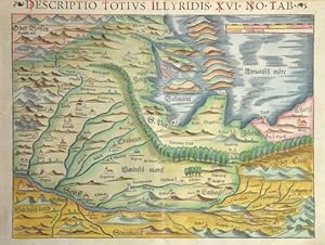
Descriptio totius Illyrides XVI no tab
Publicado por Artist: Ptolemy/Münster Sebastian Claudius ( - 1552 ) Basel ; issued in: Basle; - Sebastian Münster (1488 ? 1552) belongs tot he very important Comographers oft he Renaicance He issued his first famous Cosmographia in 1544 with 24 double paged maps with German description of the worldIt had numerous editions in different languages including Latin French Italian English and Czech The last German edition was published in 1628 long after his death The Cosmographia was one of the most successful and popular books of the 16th century It passed through 24 editions in 100 years This success was due to the notable woodcuts some by Hans Holbein the Younger Urs Graf Hans Rudolph Deutsch and David Kandel It was most important in reviving geography in, 1489
Librería: Antique Sommer& Sapunaru KG, München, Alemania
Miembro de asociación: ILAB VDA
Calificación del vendedor: 4 de 5 estrellas
Technic: Woodcut, colorit: original colored, condition: Right lower corner ,tear perfectly restored, size (in cm): 27 x 34; - Map shows total Croatia with Slovenia, on reverse beautiful representaions as titelpage; History: Following the decisive Ottoman victories, Croatia was split into civilian and military territories, with the partition formed in 1538. The military territories would become known as the Croatian Military Frontier and were under direct Imperial control. Ottoman advances in the Croatian territory continued until the 1593 Battle of Sisak, the first decisive Ottoman defeat, and stabilisation of borders. The Ottoman wars instigated great demographic changes. Croats migrated towards Austria and the present-day Burgenland Croats are direct descendants of these settlers. o replace the fleeing population, the Habsburgs encouraged the Christian populations of Bosnia and Serbia to provide military service in the Croatian Military Frontier. Serb migration into this region peaked during the Great Serb Migrations of 1690 and 1737?39. Between 1797 and 1809 the First French Empire gradually occupied the entire eastern Adriatic coastline and a substantial part of its hinterland, ending the Venetian and the Ragusan republics, establishing the Illyrian Provinces.
-
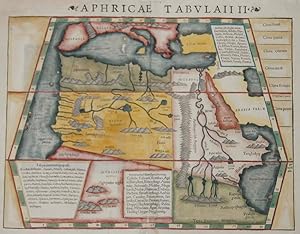
Aphricae Tabulaii II
Publicado por Artist: Ptolemy/Münster Sebastian Claudius ( - 1552 ) Basel ; issued in: Basle; - Sebastian Münster (1488 ? 1552) belongs tot he very important Comographers oft he Renaicance He issued his first famous Cosmographia in 1544 with 24 double paged maps with German description of the worldIt had numerous editions in different languages including Latin French Italian English and Czech The last German edition was published in 1628 long after his death The Cosmographia was one of the most successful and popular books of the 16th century It passed through 24 editions in 100 years This success was due to the notable woodcuts some by Hans Holbein the Younger Urs Graf Hans Rudolph Deutsch and David Kandel It was most important in reviving geography in, 1489
Librería: Antique Sommer& Sapunaru KG, München, Alemania
Miembro de asociación: ILAB VDA
Calificación del vendedor: 4 de 5 estrellas
Technic: Woodcut, colorit: colored, condition: Upper Left margin perfectly replaced, size (in cm): 27 x 34 cm; - Map shows the northern part of the African continent with the Arabian Peninsula. Rivers and mountains are roughly shown in the country on the side the climatically zones.; History: According to the "Out-of-Africa theory", Africa is considered the "cradle of mankind", where homo development led to the development of the anatomically modern human Homo sapiens. One of the earliest advanced civilizations in mankind was formed in ancient Egypt. Over the millennia, various "great empires" such as the Empire of Abyssinia emerged on the continent. There were other kingdoms in West Africa, such as the Ashanti and Haussa, but they emerged much later. There were also some important cultures in East and South Africa, as in the area of today's Sudan, then called Nubia or Kush. Nubian pharaohs ruled all of Egypt for a dynasty. For example, the inhabitants of Greater Zimbabwe were important cultures in southern Africa. This stone castle was architecturally a masterpiece at that time and important for trade between the peoples of the south and east. The Swahili were known in East Africa. North Africa was connected to Europe and the Near East by the Mediterranean rather than separated. Carthage, a foundation of the Phoenicians in what is now Tunisia, was around the middle of the 1st millennium BC. The dominant power in the western Mediterranean until it was replaced by Rome in the Punic Wars. This prevailed from 30 BC. BC (conquest of Egypt) over all of North Africa. Even the ancient Egyptians (Queen Hatshepsut) made trips to Punt, probably in what is now Somalia. The kingdom of the Queen of Sheba, which probably had its center in southern Arabia, is said to have spanned parts of the Horn from Africa to the north of Ethiopia.
-
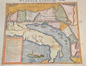
Tabula Europae V.
Publicado por Artist: Ptolemy/Münster Sebastian Claudius ( - 1552 ) Basel ; issued in: Basle; - Sebastian Münster (1488 ? 1552) belongs tot he very important Comographers oft he Renaicance He issued his first famous Cosmographia in 1544 with 24 double paged maps with German description of the worldIt had numerous editions in different languages including Latin French Italian English and Czech The last German edition was published in 1628 long after his death The Cosmographia was one of the most successful and popular books of the 16th century It passed through 24 editions in 100 years This success was due to the notable woodcuts some by Hans Holbein the Younger Urs Graf Hans Rudolph Deutsch and David Kandel It was most important in reviving geography in, 1489
Librería: Antique Sommer& Sapunaru KG, München, Alemania
Miembro de asociación: ILAB VDA
Calificación del vendedor: 4 de 5 estrellas
Technic: Woodcut, colorit: original colored, condition: Wormholes (6) perfectly restored, size (in cm): 27 x 34,5 cm; - Map shows in trapezoidal representation, Eastern Europe with the coast of the whole of Italy and the Adriatic Sea. Croatia, Slovenia, Dalmatia, Serbia and a putto on a dolphin.; History: In the historical sense, Eastern Europe refers to Ukraine, the European part of Russia, Belarus and the Republic of Moldova. Occasionally, the Caucasian countries of Georgia, Armenia and, conditionally, Azerbaijan are also seen as part of Eastern Europe. By Christian Giordano and other scholars, one of the six historical regions of Europe is called "Eastern Europe." The Eastern European countries are historically and culturally largely influenced by the Orthodox Church (Islamic Azerbaijan excepted) and were - in contrast to the Ottoman-dominated Balkans - under the rule of the Russian Empire. Like the Balkan countries, the countries of Eastern Europe were for a long time backward agricultural states (cf.: Intermediate Europe) and had no or only a limited share in the social developments of the Renaissance, Reformation and Enlightenment of the Western world.
-
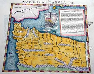
Aphricae Tabula I. 955
Publicado por Artist: Ptolemy/Münster Sebastian Claudius ( - 1552 ) Basel ; issued in: Basle; - Sebastian Münster (1488 ? 1552) belongs tot he very important Comographers oft he Renaicance He issued his first famous Cosmographia in 1544 with 24 double paged maps with German description of the worldIt had numerous editions in different languages including Latin French Italian English and Czech The last German edition was published in 1628 long after his death The Cosmographia was one of the most successful and popular books of the 16th century It passed through 24 editions in 100 years This success was due to the notable woodcuts some by Hans Holbein the Younger Urs Graf Hans Rudolph Deutsch and David Kandel It was most important in reviving geography in, 1489
Librería: Antique Sommer& Sapunaru KG, München, Alemania
Miembro de asociación: ILAB VDA
Calificación del vendedor: 4 de 5 estrellas
Technic: Woodcut, colorit: original colored, condition: Stain, 3, size (in cm): 27,5 x 34 cm; - Map shows the northern part of Africa and the southern part of Spain with the strait of Gibraltar. With decorative ship representation. Latin Edition.; History: According to the "Out-of-Africa theory", Africa is considered the "cradle of mankind", where homo development led to the development of the anatomically modern human Homo sapiens. One of the earliest advanced civilizations in mankind was formed in ancient Egypt. Over the millennia, various "great empires" such as the Empire of Abyssinia emerged on the continent. There were other kingdoms in West Africa, such as the Ashanti and Haussa, but they emerged much later. There were also some important cultures in East and South Africa, as in the area of today's Sudan, then called Nubia or Kush. Nubian pharaohs ruled all of Egypt for a dynasty. For example, the inhabitants of Greater Zimbabwe were important cultures in southern Africa. This stone castle was architecturally a masterpiece at that time and important for trade between the peoples of the south and east. The Swahili were known in East Africa. North Africa was connected to Europe and the Near East by the Mediterranean rather than separated. Carthage, a foundation of the Phoenicians in what is now Tunisia, was around the middle of the 1st millennium BC. The dominant power in the western Mediterranean until it was replaced by Rome in the Punic Wars. This prevailed from 30 BC. BC (conquest of Egypt) over all of North Africa. Even the ancient Egyptians (Queen Hatshepsut) made trips to Punt, probably in what is now Somalia. The kingdom of the Queen of Sheba, which probably had its center in southern Arabia, is said to have spanned parts of the Horn from Africa to the north of Ethiopia.
-
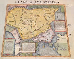
Tabula Europae IX.
Publicado por Artist: Ptolemy/Münster Sebastian Claudius ( - 1552 ) Basel ; issued in: Basle; - Sebastian Münster (1488 ? 1552) belongs tot he very important Comographers oft he Renaicance He issued his first famous Cosmographia in 1544 with 24 double paged maps with German description of the worldIt had numerous editions in different languages including Latin French Italian English and Czech The last German edition was published in 1628 long after his death The Cosmographia was one of the most successful and popular books of the 16th century It passed through 24 editions in 100 years This success was due to the notable woodcuts some by Hans Holbein the Younger Urs Graf Hans Rudolph Deutsch and David Kandel It was most important in reviving geography in, 1489
Librería: Antique Sommer& Sapunaru KG, München, Alemania
Miembro de asociación: ILAB VDA
Calificación del vendedor: 4 de 5 estrellas
Technic: Woodcut, colorit: original colored, condition: Very good, size (in cm): 27 x 34 cm; - Trapezoidal map shows Romania, Moldavia, Bulgaria, Dalmatia, Macedonia and partly Turkey.; History: In the historical sense, Eastern Europe refers to Ukraine, the European part of Russia, Belarus and the Republic of Moldova. Occasionally, the Caucasian countries of Georgia, Armenia and, conditionally, Azerbaijan are also seen as part of Eastern Europe. By Christian Giordano and other scholars, one of the six historical regions of Europe is called "Eastern Europe." The Eastern European countries are historically and culturally largely influenced by the Orthodox Church (Islamic Azerbaijan excepted) and were - in contrast to the Ottoman-dominated Balkans - under the rule of the Russian Empire. Like the Balkan countries, the countries of Eastern Europe were for a long time backward agricultural states (cf.: Intermediate Europe) and had no or only a limited share in the social developments of the Renaissance, Reformation and Enlightenment of the Western world.
-
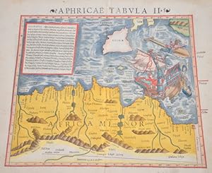
Aphricae tabula II
Publicado por Artist: Ptolemy/Münster Sebastian Claudius ( - 1552 ) Basel ; issued in: Basle; - Sebastian Münster (1488 ? 1552) belongs tot he very important Comographers oft he Renaicance He issued his first famous Cosmographia in 1544 with 24 double paged maps with German description of the worldIt had numerous editions in different languages including Latin French Italian English and Czech The last German edition was published in 1628 long after his death The Cosmographia was one of the most successful and popular books of the 16th century It passed through 24 editions in 100 years This success was due to the notable woodcuts some by Hans Holbein the Younger Urs Graf Hans Rudolph Deutsch and David Kandel It was most important in reviving geography in, 1489
Librería: Antique Sommer& Sapunaru KG, München, Alemania
Miembro de asociación: ILAB VDA
Calificación del vendedor: 4 de 5 estrellas
Technic: Woodcut, colorit: colored, condition: Perfect condition, size (in cm): 27 x 34 cm; - Map shows North Africa with the countries Algeria, Tunisia, Libya, partly Egypt, Sicily and a sailing ship in distress.; History: According to the "Out-of-Africa theory", Africa is considered the "cradle of mankind", where homo development led to the development of the anatomically modern human Homo sapiens. One of the earliest advanced civilizations in mankind was formed in ancient Egypt. Over the millennia, various "great empires" such as the Empire of Abyssinia emerged on the continent. There were other kingdoms in West Africa, such as the Ashanti and Haussa, but they emerged much later. There were also some important cultures in East and South Africa, as in the area of today's Sudan, then called Nubia or Kush. Nubian pharaohs ruled all of Egypt for a dynasty. For example, the inhabitants of Greater Zimbabwe were important cultures in southern Africa. This stone castle was architecturally a masterpiece at that time and important for trade between the peoples of the south and east. The Swahili were known in East Africa. North Africa was connected to Europe and the Near East by the Mediterranean rather than separated. Carthage, a foundation of the Phoenicians in what is now Tunisia, was around the middle of the 1st millennium BC. The dominant power in the western Mediterranean until it was replaced by Rome in the Punic Wars. This prevailed from 30 BC. BC (conquest of Egypt) over all of North Africa. Even the ancient Egyptians (Queen Hatshepsut) made trips to Punt, probably in what is now Somalia. The kingdom of the Queen of Sheba, which probably had its center in southern Arabia, is said to have spanned parts of the Horn from Africa to the north of Ethiopia.
-
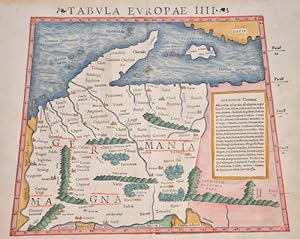
Tabula Europae IIII ( Germaniam maganm)
Publicado por Artist: Ptolemy/Münster Sebastian Claudius ( - 1552 ) Basel ; issued in: Basle; - Sebastian Münster (1488 ? 1552) belongs tot he very important Comographers oft he Renaicance He issued his first famous Cosmographia in 1544 with 24 double paged maps with German description of the worldIt had numerous editions in different languages including Latin French Italian English and Czech The last German edition was published in 1628 long after his death The Cosmographia was one of the most successful and popular books of the 16th century It passed through 24 editions in 100 years This success was due to the notable woodcuts some by Hans Holbein the Younger Urs Graf Hans Rudolph Deutsch and David Kandel It was most important in reviving geography in, 1489
Librería: Antique Sommer& Sapunaru KG, München, Alemania
Miembro de asociación: ILAB VDA
Calificación del vendedor: 4 de 5 estrellas
Technic: Woodcut, colorit: original colored, condition: Very good, size (in cm): 27 x 34 cm; - Map shows detailed Germany, the Baltic and part of the Balkans, extending to the Carpathian Mountains and the Danube. Shwon as it has been understood in the Ptolomaic time and trapezoid.; History: The concept of Germany as a distinct region in central Europe can be traced to Roman commander Julius Caesar, who referred to the unconquered area east of the Rhine as Germania, thus distinguishing it from Gaul (France), which he had conquered. In the High Middle Ages, the regional dukes, princes and bishops gained power at the expense of the emperors. Martin Luther led the Protestant Reformationagainst the Catholic Church after 1517, as the northern states became Protestant, while the southern states remained Catholic. The two parts of the Holy Roman Empire clashed in the Thirty Years' War (1618?1648). 1648 marked the effective end of the Holy Roman Empire and the beginning of the modern nation-state system, with Germany divided into numerous independent states, such as Prussia, Bavaria and Saxony.
-
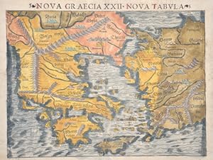
Nova Graecia XXII - Nova Tabula
Publicado por Artist: Ptolemy/Münster Sebastian Claudius ( - 1552 ) Basel ; issued in: Basle; - Sebastian Münster (1488 ? 1552) belongs tot he very important Comographers oft he Renaicance He issued his first famous Cosmographia in 1544 with 24 double paged maps with German description of the worldIt had numerous editions in different languages including Latin French Italian English and Czech The last German edition was published in 1628 long after his death The Cosmographia was one of the most successful and popular books of the 16th century It passed through 24 editions in 100 years This success was due to the notable woodcuts some by Hans Holbein the Younger Urs Graf Hans Rudolph Deutsch and David Kandel It was most important in reviving geography in, 1489
Librería: Antique Sommer& Sapunaru KG, München, Alemania
Miembro de asociación: ILAB VDA
Calificación del vendedor: 4 de 5 estrellas
Technic: Woodcut, colorit: original colored, condition: Very good, size (in cm): 26 x 34; - Map shows total Greece with the Aegean sea and the coast of Turkey, on reverse a list of greece cities.; History: Greece is considered the cradle of Western civilisation, being the birthplace of democracy, Western philosophy, Western literature, historiography, political science, major scientific and mathematical principles, Western drama and the Olympic Games. From the eighth century B.C., the Greeks were organised into various independent city-states, known as poleis (singular polis), which spanned the entire Mediterranean region and the Black Sea. Philip of Macedon united most of the Greek mainland in the fourth century BC, with his son Alexander the Great rapidly conquering much of the ancient world, from the eastern Mediterranean to India. Greece was annexed by Rome in the second century B.C., becoming an integral part of the Roman Empire and its successor, the Byzantine Empire, which adopted the Greek language and culture. The Greek Orthodox Church, which emerged in the first century A.D., helped shape modern Greek identity and transmitted Greek traditions to the wider Orthodox World. After falling under Ottoman dominion in the mid-15th century, Greece emerged as a modern nation state in 1830 following a war of independence.
-
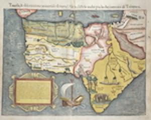
Tauola, & discrizzione universale du tutta l Africa, distesa anhce oiu la che i termini di Totlomeo
Publicado por Artist: Ptolemy/Münster Sebastian Claudius ( - 1552 ) Basel ; issued in: Basle; - Sebastian Münster (1488 ? 1552) belongs tot he very important Comographers oft he Renaicance He issued his first famous Cosmographia in 1544 with 24 double paged maps with German description of the worldIt had numerous editions in different languages including Latin French Italian English and Czech The last German edition was published in 1628 long after his death The Cosmographia was one of the most successful and popular books of the 16th century It passed through 24 editions in 100 years This success was due to the notable woodcuts some by Hans Holbein the Younger Urs Graf Hans Rudolph Deutsch and David Kandel It was most important in reviving geography in, 1489
Librería: Antique Sommer& Sapunaru KG, München, Alemania
Miembro de asociación: ILAB VDA
Calificación del vendedor: 4 de 5 estrellas
Technic: Woodcut, colorit: original colored, condition: Very good, size (in cm): 26,5 x 33,5; - Map shows total Afika with beautiful ship representation and animals in the African continent. - additional information: Italian edition; History: According to the "Out-of-Africa theory", Africa is considered the "cradle of mankind", where homo development led to the development of the anatomically modern human Homo sapiens. One of the earliest advanced civilizations in mankind was formed in ancient Egypt. Over the millennia, various "great empires" such as the Empire of Abyssinia emerged on the continent. There were other kingdoms in West Africa, such as the Ashanti and Haussa, but they emerged much later. There were also some important cultures in East and South Africa, as in the area of today's Sudan, then called Nubia or Kush. Nubian pharaohs ruled all of Egypt for a dynasty. For example, the inhabitants of Greater Zimbabwe were important cultures in southern Africa. This stone castle was architecturally a masterpiece at that time and important for trade between the peoples of the south and east. The Swahili were known in East Africa. North Africa was connected to Europe and the Near East by the Mediterranean rather than separated. Carthage, a foundation of the Phoenicians in what is now Tunisia, was around the middle of the 1st millennium BC. The dominant power in the western Mediterranean until it was replaced by Rome in the Punic Wars. This prevailed from 30 BC. BC (conquest of Egypt) over all of North Africa. Even the ancient Egyptians (Queen Hatshepsut) made trips to Punt, probably in what is now Somalia. The kingdom of the Queen of Sheba, which probably had its center in southern Arabia, is said to have spanned parts of the Horn from Africa to the north of Ethiopia.