
Importe total (1 artículo artículos):
Destino del pedido:

saxton christopher hole william (8 resultados)
Ir a los resultados principales
Tipo de artículo
- Todo tipo de artículos
- Libros (4)
- Revistas y publicaciones
- Cómics
- Partituras
- Arte, grabados y pósters
- Fotografías
- Mapas (4)
-
Manuscritos y
coleccionismo de papel
Condición
- Todo
- Nuevos
- Antiguos o usados
Encuadernación
- Todo
- Tapa dura
- Tapa blanda
Más atributos
- Primera edición (4)
- Firmado
- Sobrecubierta
- Con imágenes del vendedor (7)
- Sin impresión bajo demanda
Ubicación del vendedor
Valoración de los vendedores
-
![Imagen del vendedor de [West Riding of Yorkshire]. Eboracensis Comitatus pars Septentrionalis Vulgo West Riding. a la venta por Robert Frew Ltd. ABA ILAB](https://pictures.abebooks.com/inventory/md/md30894925645.jpg)
[West Riding of Yorkshire]. Eboracensis Comitatus pars Septentrionalis Vulgo West Riding.
Publicado por LondonImpensis Georgii Bishop & Ioannis Norton ., 1610
Librería: Robert Frew Ltd. ABA ILAB, London, Reino Unido
Miembro de asociación: ABA ILAB PBFA
Valoración del vendedor:

Mapa Original o primera edición
Original uncoloured engraved map of West Riding of Yorkshire trimmed to neatline and backed onto 18th century laid paper. Map dimensions 27 x 32 cm, overall backing-sheet size 32 x 40 cm. Faintly smudged and browned to large portion of map. An early decorative map of West Riding of Yorkshire engraved by William Hole based on the earlier maps by Elizabethan cartographer Christopher Saxton first published in the 1607 edition of William Camden's Britannia.* This example is from the first English edition of Camden's Britannia published in 1610, without any text on the verso. Embellished with compass rose, compass dividers, and decorative cartouche. *Britannia, first published in 1586, was one of the most popular and influential books of the period. The work of the Elizabethan antiquarian, William Camden (1551-1623), it was a detailed historical and topographical description of Great Britain. Its patriotic sentiments, in particular, both appealed to and generated the growing sense of nationalism that was coursing through late Tudor / early Stuart society. Between 1607 and 1637, county maps engraved by William Kip and William Hole, and based largely on Saxton's surveys, were added. (Skelton, 6).
-
![Imagen del vendedor de [Monmouthshire]. Monumethensis comitatus, quem olim incoluerunt silures. a la venta por Robert Frew Ltd. ABA ILAB](https://pictures.abebooks.com/inventory/md/md30894930062.jpg)
[Monmouthshire]. Monumethensis comitatus, quem olim incoluerunt silures.
Publicado por LondonImpensis Georgii Bishop & Ioannis Norton ., 1610
Librería: Robert Frew Ltd. ABA ILAB, London, Reino Unido
Miembro de asociación: ABA ILAB PBFA
Valoración del vendedor:
Mapa Original o primera edición
Original uncoloured engraved map of Monmouthshire trimmed to neatline and backed onto 18th century laid paper. Map dimensions 27.5 x 34 cm, overall backing-sheet size 32 x 40 cm. A bit toned mainly to bottom right corner, generally very good. An early decorative map of Monmouthshire engraved by William Hole based on the earlier maps by Elizabethan cartographer Christopher Saxton first published in the 1607 edition of William Camden's Britannia.* This example is from the first English edition of Camden's Britannia published in 1610, without any text on the verso. Embellished with royal coat of arms, compass dividers, compass rose, sea galleon, and decorative cartouche. *Britannia, first published in 1586, was one of the most popular and influential books of the period. The work of the Elizabethan antiquarian, William Camden (1551-1623), it was a detailed historical and topographical description of Great Britain. Its patriotic sentiments, in particular, both appealed to and generated the growing sense of nationalism that was coursing through late Tudor / early Stuart society. Between 1607 and 1637, county maps engraved by William Kip and William Hole, and based largely on Saxton's surveys, were added. (Skelton, 6).
-
![Imagen del vendedor de [Lancashire]. Lancastrić Comitatus palatinus olim pars brigantum. a la venta por Robert Frew Ltd. ABA ILAB](https://pictures.abebooks.com/inventory/md/md30894924813.jpg)
[Lancashire]. Lancastrić Comitatus palatinus olim pars brigantum.
Publicado por LondonImpensis Georgii Bishop & Ioannis Norton ., 1610
Librería: Robert Frew Ltd. ABA ILAB, London, Reino Unido
Miembro de asociación: ABA ILAB PBFA
Valoración del vendedor:
Mapa Original o primera edición
Original uncoloured engraved map of Lancashire trimmed to neatline and backed onto 18th century laid paper. Map dimensions 29.5 x 30.5 cm, overall backing-sheet size 32 x 40 cm. A bit of uneven toning and browning mainly to right-hand side, small loss and small wormhole to lower right corner. An early decorative map of Lancashire engraved by William Hole based on the earlier maps by Elizabethan cartographer Christopher Saxton first published in the 1607 edition of William Camden's Britannia.* This example is from the first English edition of Camden's Britannia published in 1610, without any text on the verso. Embellished with prominent compass rose, compass dividers, and decorative cartouche. *Britannia, first published in 1586, was one of the most popular and influential books of the period. The work of the Elizabethan antiquarian, William Camden (1551-1623), it was a detailed historical and topographical description of Great Britain. Its patriotic sentiments, in particular, both appealed to and generated the growing sense of nationalism that was coursing through late Tudor / early Stuart society. Between 1607 and 1637, county maps engraved by William Kip and William Hole, and based largely on Saxton's surveys, were added. (Skelton, 6).
-
![Imagen del vendedor de [East Riding of Yorkshire]. Eboracensis Comitatus.pars Orientalis Vulgo East Riding. a la venta por Robert Frew Ltd. ABA ILAB](https://pictures.abebooks.com/inventory/md/md30894930979.jpg)
[East Riding of Yorkshire]. Eboracensis Comitatus.pars Orientalis Vulgo East Riding.
Publicado por LondonImpensis Georgii Bishop & Ioannis Norton ., 1610
Librería: Robert Frew Ltd. ABA ILAB, London, Reino Unido
Miembro de asociación: ABA ILAB PBFA
Valoración del vendedor:
Mapa Original o primera edición
Original uncoloured engraved map of East Riding of Yorkshire trimmed to neatline and backed onto 18th century laid paper. Map dimensions 20.5 x 25 cm, overall backing-sheet size 32 x 40 cm. A bit of uneven toning, small hole to backing-sheet not affecting map, generally very good. An early decorative map of East Riding of Yorkshire engraved by William Hole based on the earlier maps by Elizabethan cartographer Christopher Saxton first published in the 1607 edition of William Camden's Britannia.* This example is from the first English edition of Camden's Britannia published in 1610, without any text on the verso. Embellished with compass rose and decorative cartouche. *Britannia, first published in 1586, was one of the most popular and influential books of the period. The work of the Elizabethan antiquarian, William Camden (1551-1623), it was a detailed historical and topographical description of Great Britain. Its patriotic sentiments, in particular, both appealed to and generated the growing sense of nationalism that was coursing through late Tudor / early Stuart society. Between 1607 and 1637, county maps engraved by William Kip and William Hole, and based largely on Saxton's surveys, were added. (Skelton, 6).
-

Christopher Saxton 1610 Hand-Coloured Map Of Herefordshire. Frugiferi Ac Amaeni Herefordiae Comitatus
Publicado por Camden's Britannia, 1610
Librería: Lazarus Books Limited, Blackpool, LANCS, Reino Unido
Valoración del vendedor:

Framed. Condición: Very Good. (Christopher & Hole, William Ilustrador. 1610 Hand coloured engraved map, title cartouche and royal arms, 285 x 310 mm, framed and glazed. The county title is in Latin, contained within an elaborate cartouche. Place names are in English, but the names of the surrounding counties are in Latin. clearly-engraved map, closely following Saxton's general map of 1583, showing the rivers, towns, principal villages, bridges and a few hills and forests,all coloured in. Map age toned is only fault. Book.
-
![Imagen del vendedor de Cestriae. [Cheshire] a la venta por Peter Harrington. ABA/ ILAB.](https://pictures.abebooks.com/inventory/md/md7089061436.jpg)
Cestriae. [Cheshire]
Publicado por London: 1610, 1610
Librería: Peter Harrington. ABA/ ILAB., London, Reino Unido
Miembro de asociación: ABA ILAB PBFA
Valoración del vendedor:
A wonderful county map of Cheshire from William Camden's historic and important atlas 'Britannia'; first published in 1607. Originally, in 1586, Camden's work was a detailed historical and topographical description of Britain. Hole & Kip added their maps to this work in 1607. The maps are heavily based on the earlier work by the Elizabethan cartographer Christopher Saxton. This map comes from the second edition, printed only 3 years later. Interesting embellishments add and complement this very early county map. Size: 290 x 340 mm. Copperplate engraving with hand colour. Map has been cleaned, and partially re-margined, but generally in good condition.
-
![Imagen del vendedor de Oxoniensis. [Oxfordshire] a la venta por Peter Harrington. ABA/ ILAB.](https://pictures.abebooks.com/inventory/md/md7089061456.jpg)
Oxoniensis. [Oxfordshire]
Publicado por London: 1637, 1637
Librería: Peter Harrington. ABA/ ILAB., London, Reino Unido
Miembro de asociación: ABA ILAB PBFA
Valoración del vendedor:
A wonderfully decorative map of Oxfordshire, engraved by William Hole and published in William Camden's 'Britannia' atlas. Originally, in 1586, Camden's work was a detailed historical and topographical description of Britain. Hole & Kip added their maps to this work in 1607. The maps are heavily based on the earlier work by the Elizabethan cartographer Christopher Saxton. The map is embellished with a splendid royal coat of arms, a compass rose and a mannerist title cartouche and mileage scale. Size: 290 x 320 mm. Copperplate engraving with hand colour. Minor repair to lower central fold, otherwise in very good condition.
-
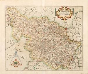
Eboracensis Comitatus pars Occidentalis vulgo West Riding.
Publicado por London: 1637, 1637
Librería: Peter Harrington. ABA/ ILAB., London, Reino Unido
Miembro de asociación: ABA ILAB PBFA
Valoración del vendedor:
Third edition. A wonderful, early map of the West Riding of Yorkshire engraved by William Hole, based on the earlier map of Christopher Saxton. The map is embellished by a mileage scale, a compass rose and a divider together with a mannerist style decorative title cartouche in upper right corner. Towns, cities and villages are highlighted in red, the hills and dales are well defined as are rivers and woods. Size: 305 x 355 mm. Copperplate engraving with hand colour. Some repair work to lower border and margins, however in good overall condition.
