
Importe total (1 artículo artículos):
Destino del pedido:

rizzi zannoni giovanni antonio bartolomeo (4 resultados)
Ir a los resultados principales
Tipo de artículo
- Todo tipo de artículos
- Libros (4)
- Revistas y publicaciones
- Cómics
- Partituras
- Arte, grabados y pósters
- Fotografías
- Mapas
-
Manuscritos y
coleccionismo de papel
Condición
- Todo
- Nuevos
- Antiguos o usados
Encuadernación
- Todo
- Tapa dura
- Tapa blanda
Más atributos
- Primera edición
- Firmado
- Sobrecubierta
- Con imágenes del vendedor (3)
- Sin impresión bajo demanda
Ubicación del vendedor
Valoración de los vendedores
-

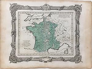
Carte de la reunion de la Navarre, Bearn, Armagnac, Foix, Albret, Bigorre, Vendome, Perigord, et du Comte de Limoges a la Couronne de France sous Henri IV
Publicado por Bourdeaux, 1764
Librería: Argosy Book Store, ABAA, ILAB, New York, NY, Estados Unidos de America
Miembro de asociación: ABAA ILAB
Valoración del vendedor:

unbound. Condición: very good. Map. Hand colored engraving, uncolored cartouche. Image measures 10 x 11 1/2". This map of France offers ample detail about the French kingdom during the reign of Henri IV. It is meant to represent the reunification of the provinces listed in the title. It extends from the Atlantic Ocean and the southern border of England to the western border of Germany, and the Mediterranean sea. Published in 1764, the map is labeled with rivers, cities, and lakes, and forests are depicted pictorially. An appropriately uncolored title cartouche in the lower left is decorated with flowers. It is in excellent condition with no chips or tears. Giovanni Antonio Bartolomeo Rizzi Zannoni (1736--1814), an Italian cartographer active in Venice and Naples, was one of the leading cartographers of the 18th century. He is admired for his careful and precise work, which responded to the growing demand in this period for accuracy and detail.
-
a la fin du Regne d'Henri IV; la Bresse et le Bugey sont reunis a la Couronne en echange du Marqt de Saluces
Publicado por Bourdeaux, 1764
Librería: Argosy Book Store, ABAA, ILAB, New York, NY, Estados Unidos de America
Miembro de asociación: ABAA ILAB
Valoración del vendedor:
unbound. Condición: very good. Map. Hand colored engraving. Image measures 9 3/4 x 12". This map of France offers ample detail about the French kingdom at the end of the reign of Henri IV. It extends from the Atlantic Ocean and the southern border of England to the western border of Germany, and the Mediterranean sea. Published in 1764, the map is labeled with rivers, cities, and lakes. It is in excellent condition with no chips or tears. Giovanni Antonio Bartolomeo Rizzi Zannoni (1736--1814), an Italian cartographer active in Venice and Naples, was one of the leading cartographers of the 18th century. He is admired for his careful and precise work, which responded to the growing demand in this period for accuracy and detail.
-
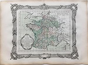
La France
Publicado por Bourdeaux, 1764
Librería: Argosy Book Store, ABAA, ILAB, New York, NY, Estados Unidos de America
Miembro de asociación: ABAA ILAB
Valoración del vendedor:
unbound. Condición: very good. Map. Hand colored engraving, uncolored cartouche. Image measures 10 x 11 1/2". This map of France offers ample detail about the French kingdom during the reign of Charles VII. It extends from the Atlantic Ocean and the southern border of England to the western border of Germany, and the Mediterranean sea. Published in 1764, the map is labeled with rivers, cities, and lakes, and forests are depicted pictorially. An appropriately uncolored title cartouche in the lower left is decorated with flowers. It is in excellent condition with no chips or tears. Giovanni Antonio Bartolomeo Rizzi Zannoni (1736--1814), an Italian cartographer active in Venice and Naples, was one of the leading cartographers of the 18th century. He is admired for his careful and precise work, which responded to the growing demand in this period for accuracy and detail.
-

L'Alemagne
Publicado por Lattre, Bordeaux, 1783
Librería: Argosy Book Store, ABAA, ILAB, New York, NY, Estados Unidos de America
Miembro de asociación: ABAA ILAB
Valoración del vendedor:
unbound. Map. Hand colored engraving, uncolored cartouche. Image measures 10 x 11 1/2". This highly detailed map of Germany extends to include present-day Belgium, Netherlands, and parts of Poland. Cities, rivers, lakes, and regions are labeled. Published circa 1783, the map depicts Prussia's territorial gains after the First Partition of Poland. An appropriately uncolored title cartouche in the lower left features an eagle and regalia. Giovanni Antonio Bartolomeo Rizzi Zannoni (1736--1814), an Italian cartographer active in Venice and Naples, was one of the leading cartographers of the 18th century. He is admired for his careful and precise work, which responded to the growing demand in this period for accuracy and detail.
