Importe total (1 artículo artículos):
Destino del pedido:

ptolemaeus claudius girolamo ruscelli (3 resultados)
Ir a los resultados principales
Tipo de artículo
- Todo tipo de artículos
- Libros (3)
- Revistas y publicaciones
- Cómics
- Partituras
- Arte, grabados y pósters
- Fotografías
- Mapas
-
Manuscritos y
coleccionismo de papel
Condición
- Todo
- Nuevos
- Antiguos o usados
Encuadernación
- Todo
- Tapa dura
- Tapa blanda
Más atributos
- Primera edición (1)
- Firmado
- Sobrecubierta
- Con imágenes del vendedor
- Sin impresión bajo demanda
Ubicación del vendedor
Valoración de los vendedores
-
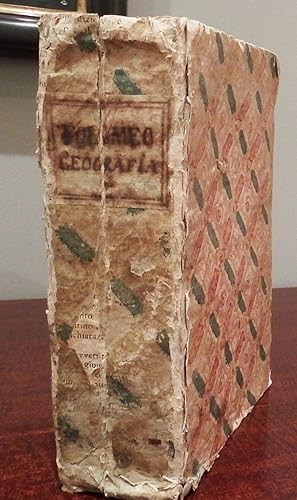
La Geografia. Translated from Greek into Italian by Geronimo Ruscelli.
Publicado por Venice: Heirs of Melchior Sessa, 1599., 1599
Librería: Arader Galleries - AraderNYC, New York, NY, Estados Unidos de America
Valoración del vendedor:

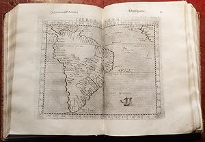
PTOLEMAEUS, Claudius (c.100-170). Geografia di Claudio Tolomeo Alessandrino, Tradotta di Greco nell'Idioma Volgare Italiano, da Girolamo Ruscelli, et hora nuovamente ampliata da Gioseffo Rosaccio. Venice: Heirs of Melchior Sessa, 1599. 2 parts in one volume. 4to., (9 5/8 x 6 6/8 inches). Woodcut device on general title-page (lower right-hand corner renewed) and sectional title-page for Espositioni et Introdottioni Universali di Ieronimo Ruscelli. 69 double-page engraved maps after Giacomo Gastaldi and others, including 27 maps of the Ancient World, and 42 maps of the Modern World, woodcut diagrams in the text, including some full-page, woodcut initials. 18th-century half calf, marbled paper boards (head and foot of the spine strengthened, worn). Provenance: with the near contemporary ownership inscription of Gio. Batta. MareSisi on the title-page; with the woodcut armorial library label of Ludovico Amorini Bolognini on the front paste-down Fourth revised and enlarged edition of Ruscelli's translation of Ptolemy, edited by Giuseppe Rosaccio, the second issue with the title-page dated 1598. With SIX ENTIRELY NEW MAPS, including Rosaccio's double-hemisphere world map (Shirley 217), and "America", being a second edition of Giovanni's Botero's scarce map of the Western Hemisphere, with a line visible around the continent, based on the work of Giovanni Lorenzo d'Anania published in Venice in 1582 (Burden 54), and Ortelius' map of America, and shows an unknown Southern continent attached to New Guinea. The other maps are reprinted from the earlier Ruscelli editions of 1561, 1562, 1564 and 1574, by Giulio and Livio Sanuto of Gastaldi's maps first published in Venice in 1548, with the addition of decorative motifs and new discoveries. Adams P-2237; Sabin 66507. Catalogued by Kate Hunter.
-
La Geografia. Translated from Greek into Italian by Geronimo Ruscelli
Publicado por Venice: Giordano Stella, 1564., 1564
Librería: Arader Galleries - AraderNYC, New York, NY, Estados Unidos de America
Valoración del vendedor:
3 parts in one volume, 4to., (9 2/8 x 6 4/8 inches). General title-page with woodcut device (ownership inscription excised from lower edge), sectional title-pages for Espositioni et Introdottioni Universali di Ieronimo Ruscelli and Discorso Universale di M. Gioseppe Moleto. 2 fine woodcut portraits of Ptolemy observing the heavens, 66 fine double-page engraved maps mounted on guards, including the world map Orbis Descriptio, woodcut diagrams in the text, including some full-page, woodcut initials (first gathering quite loose, some inoffensive wormtracks to guards). Early Italian patterned paper boards (a bit worn). Second edition of Ruscelli's Ptolemy, a reissue of the first of 1561, the 66 maps being printed from the same plates and with the same irregular numbering. These important maps are enlarged copies by Giulio and Livio Sanuto of Gastaldi's maps first published in Venice in 1548, except Universale novo, which was drawn on a new projection and renamed Orbis descriptio. Other notable maps include: "Septemtronalum partium nova tabula" , a reduced version of the Nicolo Zeno map of the North Atlantic Ocean of 1558 and including many fictitious islands; "Tierra Nueva", a map of the east coast of North America showing the Hudson and St. Lawrence Rivers; "Nueva Hispania Tabula Nova" showing the Yucatan as a peninsula; other maps of America are "Tierra Nova showing South America, "Brasil Nuova Tavola", "Isola Cuba Nova", and "Isola Spagnola Nova"; "India Tercera Nuova Tavola" shows the East Indies; and "Orbis Discriptio" the twin hemisphere new world map, which as Shirley reports, is the earliest of its kind to appear in an atlas, shows not only North and south America, but also the islands of New Guinea. Maps not found in the previous Gastaldi edition of 1548 are: Scandinavia (after Jacob Ziegler, 1532); Brasil (after Ramusio); the Arctic regions; South Africa; and a navigational chart of the World. BM/STC Italian, p.543; Phillips Atlases 373; Sabin 66504. Catalogued by Kate Hunter.
-
La Geografia. nuovamente tradotta di Greco in Italiano, da Girolamo Ruscelli
Publicado por Venice: Vincenzo Valgrisi, 1561., 1561
Librería: Arader Galleries - AraderNYC, New York, NY, Estados Unidos de America
Valoración del vendedor:
Original o primera edición
3 parts in one volume. 4to., (9 2/8 x 6 2/8 inches). Woodcut printer's devices on title-pages and at end of part 2, 64 engraved double-page maps mounted on guards, comprising 27 maps of the ancient world and 37 maps of the modern world with letterpress descriptive text on rectos, woodcut diagrams throughout, woodcut initials (first title-page supplied, and a bit short, some light, mostly marginal waterstaining throughout, front endpaper with wormtracks). Contemporary vellum over paste-board, title lettered in gilt on the spine (a bit marked); preserved in a modern red cloth clamshell box. Provenance: obscured contemporary Italian ownership inscription and ink library stamp offset onto front free endpaper from original title-page; replaced title-page with the ink library stamp of the convent of San Michele in Bosco, Bologna at the foot. First edition of Girolamo Ruscelli's Italian translation of Ptolemy's "Geography". Most of the maps are enlarged copies of the Gastaldi maps from the Venice 1548 edition made by Giulio and Livio Sanuto: notable maps include: "Septemtronalum partium nova tabula" , a reduced version of the Nicolo Zeno map of the North Atlantic Ocean of 1558 and including many ficticious islands; "Tierra Nueva", a map of the east coast of North America showing the Hudson and St. Lawrence Rivers; "Nueva Hispania Tabula Nova" showing the Yucatan as a peninsula; other maps of America are "Tierra Nova showing South America, "Brasil Nuova Tavola", "Isola Cuba Nova", and "Isola Spagnola Nova"; "India Tercera Nuova Tavola" shows the East Indies; and "Orbis Discriptio" the twin hemisphere new world map, which as Shirley reports, is the earliest of its kind to appear in an atlas, shows not only North and south America, but also the islands of New Guinea. Maps not found in the previous Gastaldi edition of 1548 are: Scandinavia (after Jacob Ziegler, 1532); Brasil (after Ramusio); the Arctic regions; South Africa; and a navigational chart of the World (Shirley 111). Adams P-2235; Alden and Landis 561/42; Burden 29, 30, and 31; Norderskiöld Collection 2:216; Phillips "Atlases" 371; Sabin 66503; Shirley 110 and 111. Catalogued by Kate Hunter.