
Importe total (1 artículo artículos):
Destino del pedido:

nicholas short paul lowman stanley (33 resultados)
Ir a los resultados principales
Tipo de artículo
- Todo tipo de artículos
- Libros (33)
- Revistas y publicaciones
- Cómics
- Partituras
- Arte, grabados y pósters
- Fotografías
- Mapas
-
Manuscritos y
coleccionismo de papel
Condición
- Todo
- Nuevos
- Antiguos o usados
Encuadernación
Más atributos
- Primera edición (10)
- Firmado (3)
- Sobrecubierta (2)
- Con imágenes del vendedor (2)
- Sin impresión bajo demanda
Ubicación del vendedor
Valoración de los vendedores
-

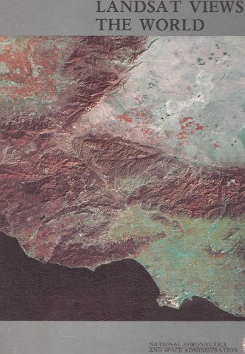
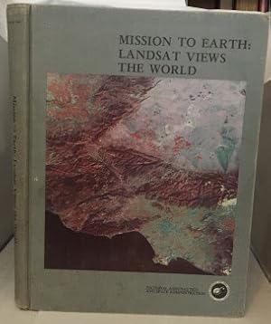
Mission to Earth: Landsat Views the World (NASA SP-360)
Publicado por NASA
Librería: ThriftBooks-Atlanta, AUSTELL, GA, Estados Unidos de America
Valoración del vendedor:

Hardcover. Condición: Fair. No Jacket. Missing dust jacket; Readable copy. Pages may have considerable notes/highlighting. ~ ThriftBooks: Read More, Spend Less 6.15.
-

Mission to Earth: Landsat Views the World (NASA SP-360)
Publicado por NASA, 1976
ISBN 10: 1114110752ISBN 13: 9781114110755
Librería: HPB-Red, Dallas, TX, Estados Unidos de America
Valoración del vendedor:
Libro
hardcover. Condición: Good. Connecting readers with great books since 1972! Used textbooks may not include companion materials such as access codes, etc. May have some wear or writing/highlighting. We ship orders daily and Customer Service is our top priority!.
Más opciones de compra de otros vendedores en IberLibro
Usado desde EUR 9,61
-
Mission to Earth: Landsat Views the World
Librería: Visible Voice Books, Cleveland, OH, Estados Unidos de America
Valoración del vendedor:

Condición: Very Good. NASA Washington DC 1976 Binding: Hardcover.
-
Mission to Earth: Landsat Views the World (NASA SP-360)
Publicado por NATIONAL AERONAUTICS & SPACE
Librería: Wonder Book, Frederick, MD, Estados Unidos de America
Miembro de asociación: ABAA ILAB
Valoración del vendedor:
Condición: Good. Good condition. Owner's name on endpage. (Earth, space) NOT AVAILABLE FOR SHIPMENT OUTSIDE OF THE UNITED STATES.
-
Mission to Earth: Landsat Views of the World
Publicado por NASA and General Electric, Washington, D.C., 1976
Librería: Weller Book Works, A.B.A.A., Salt Lake City, UT, Estados Unidos de America
Miembro de asociación: ABAA ILAB
Valoración del vendedor:
Grey cloth. Very good with lightly rubbed and bumped edges. Folio.
-
Mission to Earth: Landsat Views the World
Publicado por National Aeronautics And Space Administration, Washington, D. C., 1976
Librería: KULTURAs books, Los Angeles, CA, Estados Unidos de America
Valoración del vendedor:
Hardcover. Condición: Very Good+. Illustrated photo on gray boards, clean and bright, shelf wear to edges. Book is firm in binding, 400 plates, color and bl&w. Space Portrait of the U.S. on front and rear free endpapers. No dust jacket. Landsat information, and a glossary of terms. Invaluable resource for anyone interested in viewing the earth from the air. Free of any markings, not ex-library.; Folio 13" - 23" tall; 459 pages.
-
Mission to Earth: Landsat Views the World
Publicado por Nasa, Washington, DC, 1976
Librería: Between the Covers-Rare Books, Inc. ABAA, Gloucester City, NJ, Estados Unidos de America
Miembro de asociación: ABAA ESA ILAB IOBA
Valoración del vendedor:
Original o primera edición
Hardcover. Condición: Very Good. First edition. Very good hardcover. First edition. Text clean. Illustrated. Corners on cover are bent. Very light soiling to cover. Large book. Please Note: This book has been transferred to Between the Covers from another database and might not be described to our usual standards. Please inquire for more detailed condition information.
-
MISSION TO EARTH: Landsat Views the World
Publicado por National Aeronautics and Space Administration, Washington, DC, 1976
Librería: Riverow Bookshop, Owego, NY, Estados Unidos de America
Miembro de asociación: ABAA ILAB
Valoración del vendedor:
Cloth (Hrdcvr). Condición: Fair/NO DUSTJACKET. Photograph (Color) Ilustrador. Washington, DC: National Aeronautics and Space Administration. Fair/NO DUSTJACKET. 1976. Cloth (Hrdcvr). 4to., 459 pp., inside hinges weakened, cover worn some, corners bumped, some yellowing on pages .
-
MISSION TO EARTH: LANDSAT VIEWS THE WORLD
Publicado por National Aeronautics and Space Administration, 1976
Librería: THE FINE BOOKS COMPANY / A.B.A.A / 1979, ROCHESTER, MI, Estados Unidos de America
Miembro de asociación: ABAA ILAB
Valoración del vendedor:
Original o primera edición
FIRST EDITION. MISSION TO EARTH: LANDSAT VIEWS THE WORLD, National Aeronautics and Space Administration, 1976, first edition, vg in cloth boards with slight soiling to covers. The results of four years of Landsat photographs taken from space depicting the Earth's surface on a global scale and resolution for the first time. Replete with color photos on virtually every page.
-
Mission to Earth: Landsat Views the World
Publicado por NASA, Washington D.C., 1976
Librería: Cultural Connection, Cape Coral, FL, Estados Unidos de America
Valoración del vendedor:
Scientific and Technical Information Office. Ex-lib with a few stamps, blindstamps and pocket. Large folio. 14" x 10 3/4". Pictorial grey cloth. NASA SP; 360. Map endpages. Printed on slick paper. x, 459 pages. 400 beautiful high quality color plate maps taken by the satellite. 3 appendices: A. The Landsat System, B. Glossary of technical terms, C. Index of plates. Very good or better.
-
Mission to Earth: Landsat views the world
Publicado por Washington, D.C. NASA 1976., 1976
Librería: Crabtree's Collection Old Books, Sebago, ME, Estados Unidos de America
Valoración del vendedor:
VG. Illustrated by Illus.
-
MISSION TO EARTH: LANDSAT VIEWS THE WORLD
Publicado por USGPO.United States Government Printing NASA.NASA SP-360 1976 TP, Washington, D. C, 1976
ISBN 10: 9997585186ISBN 13: 9789997585189
Librería: WONDERFUL BOOKS BY MAIL, Durham-CA, CA, Estados Unidos de America
Valoración del vendedor:
Libro Original o primera edición
Hardcover. Condición: Very Good. Illustrated by Glossy Color Photos,bw PHOTOS Ilustrador. First Edition?. VERY GOOD CONDITION, clean, solid, bright.; Black titles on grey cloth hard covers. cover space photo shows mostly red landmass, desert top, black ocean bottom.suspect so cal. ; 459pg pages; IMPORTANT PHOTOS FROM PACE EXPLORATION PROGRAMS FIRST DECADE. SCIENTIFIC AND TECHNICAL INFORMATION DIVISION, OFFICE OF TECHNOLOGY UTILIZATION.MANY EARLY SATILITE INFO GATHERING TECHNOLOGIES DESCRIBED.
-
Mission to Earth: Landsat Views the World
Publicado por NASA, Washington D.C., 1976
Librería: Cultural Connection, Cape Coral, FL, Estados Unidos de America
Valoración del vendedor:
Scientific and Technical Information Office. Large folio. 14" x 10 3/4". Pictorial grey cloth. NASA SP; 360. Map endpages. Printed on slick paper. x, 459 pages. 400 beautiful high quality color plate maps taken by the satellite. 3 appendices: A. The Landsat System, B. Glossary of technical terms, C. Index of plates. A few very light fox spots first couple pages front and back otherwise clean and bright. Very good or better.
-
MISSION TO EARTH: LANDSAT VIEWS OF THE WORLD
Publicado por Washington, DC: National Aeronautics and Space Administration, 1976., 1976
Librería: Blue Mountain Books & Manuscripts, Ltd., Cadyville, NY, Estados Unidos de America
Valoración del vendedor:
Condición: Very good. Washington, DC: National Aeronautics and Space Administration, 1976. 1976. Very good. - Quarto [14 inches high by 10-1/2 inches wide], pictorial gray cloth with a color view of Southern California from space on the front cover. The binding is rubbed with some small stains to the rear cover. The spine & front edge of the front cover are slightly darkened. ix & 459 pages. Profusely illustrated in color and black & white. Very good.
-
Mission to Earth: Landsat Veiws the World
Publicado por National Aeronautics, Washington, DC, 1976
Librería: Ann Becker, Houston, TX, Estados Unidos de America
Valoración del vendedor:
Hardcover. Condición: Very Good. Estado de la sobrecubierta: No Dust Jacket.
-
Mission to Earth: Landsat Views the World
Publicado por National Aeronautics and Space Administration, Washington, 1976
Hardcover. Condición: Very Good. Withdrawl from major Canadian museum (non-circulating) ; tight clean and bright with unmarked text and illustrations; in illustrated gray cloth. Imposing book in size and scope. ; Nasa SP-360; 11 x 14"; 459 pages.
-
Mission to Earth: Landsat Views the World
Publicado por National Aeronautics and Space Administration, Washington, DC, 1976
Librería: Main Street Fine Books & Mss, ABAA, Galena, IL, Estados Unidos de America
Miembro de asociación: ABAA ILAB MWABA
Valoración del vendedor:
Original o primera edición
Hardcover. Folio. Grey pictorial cloth. ix, 459pp. Numerous illustrations (most color), pictorial endpapers. Very good. Tight, clean, handsome first edition.
-

Mission to Earth: Landsat Views the World
Publicado por National Aeronautics and Space Administration, 1976
ISBN 10: 1135285667ISBN 13: 9781135285661
Librería: Powell's Bookstores Chicago, ABAA, Chicago, IL, Estados Unidos de America
Miembro de asociación: ABAA ILAB
Valoración del vendedor:
Libro
Condición: Used - Very Good. 1976. Pictorial boards. Folio. ix & 459 pp. Profusely illustrated. Moderate shelf wear to boards. Altogether a copy in Very Good condition.
-
Mission to Earth: :Landsat Views the World
Publicado por GPO/National Aeronautics and Space Administration, Washington D.C., 1976
Librería: La Playa Books, San Diego, CA, Estados Unidos de America
Valoración del vendedor:
Hardcover. Condición: Used - near very good. sm folio; 459pp. Inscribed on title page by co-author, William A. Finch. An obit for him is taped to first blank. A square tight copy with unmarked text. Pictorial covers scuffed. At almost 7 lbs book will require additional postage. Inscribed.
-
Mission The Earth: Landsat Views The World
Publicado por National Aeronautics and Space Administration, 1976
Librería: Callaghan Books South, New Port Richey, FL, Estados Unidos de America
Valoración del vendedor:
Libro
Cloth. Condición: Fine. (Additional Postage Will Be Needed) Very large, very heavy book, gray cloth, beautfiul color photo of mountains at center front. (The first color photo-mosaic of the Contiguous United States) 439 heavy glossy pages of photography, color aerial map from space inside front cover and adjacent end paper, gray map of same area inside back cover and adjacent end paper. Light white scratch near top back. Near Very Fine.
-
Mission to Earth: Landsat Views the World (NASA SP-360)
Publicado por NATIONAL AERONAUTICS & SPACE
Librería: Wonder Book, Frederick, MD, Estados Unidos de America
Miembro de asociación: ABAA ILAB
Valoración del vendedor:
Condición: Good. Good condition. No Dust Jacket Owner's name on verso front endpage. (space photography, geography) NOT AVAILABLE FOR SHIPMENT OUTSIDE OF THE UNITED STATES.
-
MISSION TO EARTH: LANDSAT VIEWS THE WORLD (NASA SP-630)
Publicado por WASHINGTON D.C. NASA PUB 1976., 1976
Librería: JOHN LUTSCHAK BOOKS, BURLINGTON, WI, Estados Unidos de America
Valoración del vendedor:
Original o primera edición
FINE WITHOUT D.J. GREY CLOTH COVERED BOARDS WITH BLACK TITLES TO THE SPINE AND FRONT COVER WITH PICTORIAL FRONT COVER, AND MAP ENDPAPERS. BOOK IS FINE WITHOUT ANY MARKS TO THE BINDING OR THE TEXT. A BEAUTIFUL CLEAN, BRIGHT, UNFADED COPY WITH NO REMAINDER MARK. FIRST EDITION. Binding is HARDCOVER.
-
Mission to Earth: Landsat Views the World (NASA SP-360)
Publicado por NASA, 1976
Librería: Sequitur Books, Boonsboro, MD, Estados Unidos de America
Miembro de asociación: IOBA
Valoración del vendedor:
Libro Ejemplar firmado
hardcover. Condición: As New. *Signed by three authors.* Bound in publisher's cloth. Hardcover. Good binding and cover. Clean, unmarked pages. ix, 459 pages : illustrations ; 36 cm. NASA SP (Series), 360. *Autographed by author.* This is an oversized or heavy book, which requires additional postage for international delivery outside the US. Signed.
-
MISSION TO EARTH: LANDSAT VIEWS THE WORLD.
Publicado por NASA (USA), 1976
Librería: Cambridge Rare Books, Cambridge, GLOUC, Reino Unido
Valoración del vendedor:
PAPERBACK. Condición: GOOD. 1976. NASA (USA). Book- Good, corners and top edge bumped, edges rubbed. 14x10.5. 459pp. colour and b/w photos and maps throughout, colour front endpaper photo, b/w back endpaper photo. A vivid collection of satellite photographs of the Earth, depicting the Earth's surface from a perspective unique in its breadth and detail.
-
Mission to earth: Landsat views the world. Mit 400 farbigen Abb.
Publicado por Washington, National Aeronautics and Space Administration, 1976
Librería: WILFRIED MELCHIOR · ANTIQUARIAT & VERLAG, Spreewaldheide, Alemania
Valoración del vendedor:
459 S englisch. Folio (35,5 x 27 cm). Farbig illustr. Orig.-Leinen (Ecken und Kapitale leicht bestoßen). - Titelblatt am Oberrand mit Stempel eines Professors, Innen sehr guter Zustand. 1. Earth-Photographs from space. 2. Astronautics in earth science. I. Short, Nicholas M. II. Series: United States. National Aeronautics and Space Administration. - Luftbildatlas der Erde: Ein Atlas aus dem All gesehen. Die Projektionen in Farbe stellten seinerzeit einen Meilenstein der Luftbildfotografie dar. Techniken und Verfahren werden erläutert. (NASA SP, 360).
-
Mission To Earth: Landsat Views The World (Nasa Sp - 360)
Publicado por NASA, Washington D. C., 1976
Librería: S. Howlett-West Books (Member ABAA), Modesto, CA, Estados Unidos de America
Miembro de asociación: ABAA ILAB
Valoración del vendedor:
Original o primera edición
Hardcover. Condición: Very Good-. Estado de la sobrecubierta: Very Good. 1st Edition; 1st Printing. Color Illustrations; This book is in Very Good- condition and is lacking a dust jacket. The spine ends and corners of the book covers have some light bumping, rubbing and edge wear. There is some ground-in dirt and fingermarking to the covers as well. The text pages are generally clean and bright. Due to the extreme weight of this book, postage will have to be determined at time of ordering. "The Landsat program is the longest-running enterprise for acquisition of satellite imagery of Earth. On July 23, 1972 the Earth Resources Technology Satellite was launched. This was eventually renamed to Landsat. [1] The most recent, Landsat 8, was launched on February 11, 2013. The instruments on the Landsat satellites have acquired millions of images. The images, archived in the United States and at Landsat receiving stations around the world, are a unique resource for global change research and applications in agriculture, cartography, geology, forestry, regional planning, surveillance and education, and can be viewed through the U. S. Geological Survey (USGS) 'EarthExplorer' website. Landsat 7 data has eight spectral bands with spatial resolutions ranging from 15 to 60 meters (49 to 197 ft) ; the temporal resolution is 16 days. [2] Landsat images are usually divided into scenes for easy downloading. Each Landsat scene is about 115 miles long and 115 miles wide (or 100 nautical miles long and 100 nautical miles wide, or 185 kilometers long and 185 kilometers wide). " (from Wikipedia).
-
Mission To Earth. Landsat Views the World.
Publicado por Washington, Washington, National Aeronautics and Space Administration, ., 1976
Librería: Antiquariat Atlas, Einzelunternehmen, Hamburg, Alemania
Valoración del vendedor:
Pappband, 4°, illustrierte Vorsätze, 459 S., 400 Tafeln mit farbigen Abbildungen; -Einband berieben. Buchblock leicht verzogen, gutes Exemplar. Publikation der ersten Abbildungen des 1972 begonnenen Landsat Erdbeobachtungsprogramms der NASA.
-
Mission to Earth: Landsat Views the World (NASA SP-360)
Publicado por NATIONAL AERONAUTICS & SPACE
Librería: Wonder Book, Frederick, MD, Estados Unidos de America
Miembro de asociación: ABAA ILAB
Valoración del vendedor:
Condición: Very Good. Washington, D.C.: NASA, 1976. Folio Hardcover. 459pp. B/W and color plates and tables. Very Good book. (space photography, space exploration, earth) Inquire if you need further information. NOT AVAILABLE FOR SHIPMENT OUTSIDE OF THE UNITED STATES.
-
Mission to Earth; Landsat Views the World. NASA SP-360
Publicado por National Aeronautics and Space Administration, Scientific and Technical Office, Washington, DC, 1976
Librería: Ground Zero Books, Ltd., Silver Spring, MD, Estados Unidos de America
Valoración del vendedor:
Original o primera edición
Hardcover. Condición: Good. Presumed First Edition, First printing. Format is approximately 10.75 inches by 14 inches. ix, [1], 459, Illustrated endpapers (color map at front, black and white map at back). Illustrations (with 400 plates [most in color]). Maps. Appendix A--The Landsat System. Appendix B--Glossary of Technical Terms. Appendix C--Index of Plates. Cover has some wear and soiling. Some edge soiling. Minor ink marks on some pages noted. This is a compendium of outstanding Landsat satellite photographs depicting the Earth's surface from space. Paul Lowman is a geologist, with degrees from Rutgers and the University of Colorado. He was hired by NASA in 1959, the first geologist to be employed by the agency. He took part in the Mercury, Gemini, Apollo, and Skylab programs as principal investigator for terrain photography. He was Principal Investigator for a Shuttle Imaging Radar Experiment, covering the Canadian Shield, in 1984. Nicholas Martin Short, is a geologist who received his Ph.D. degree from the Massachusetts Institute of Technology. In his early career, he worked for the Lawrence Livermore Laboratory, California (Underground Nuclear Explosions; Plowshare Program). During the 1960s he specialized in the effects of underground nuclear explosions and asteroidal impacts on rocks (helping to establish the new field of Shock Metamorphism), and was one of the original Principal Investigators of the Apollo 11 and 12 moon rocks. He joined NASA's Goddard Space Flight Center in 1969 as one of the first discipline specialists supporting the Landsat program and related remote sensing projects. Over the next 19 years, he authored Planetary Geology, The Landsat Tutorial Workbook, and The HCMM Anthology and co-authored Volcanic Landforms and Surface Features, Mission to Earth: Landsat Views the World, and Geomorphology from Space, along with 85 publications dealing mainly with geological topics.
-
Mission To Earth: Landsat Views The World
Publicado por National Aeronautics and Space Administration, Washington, DC, 1976
Librería: The Wild Muse, Granville, NY, Estados Unidos de America
Valoración del vendedor:
Original o primera edición
Hard. Condición: Fine. No Jacket. 1st. First edition. Hard cover. Published Washington, DC: National Aeronautics and Space Administration, 1976. Folio, 10 3/4" x 14 1/2", ix+459pp., illustrated with 400 color plates, maps, map endpapers. Pictorial cloth with black titles. Minor bump to top tip of front cover. A fine copy. Size: Folio.

