Importe total (1 artículo artículos):
Destino del pedido:

moll herman 1732 (47 resultados)
Ir a los resultados principales
Tipo de artículo
- Todo tipo de artículos
- Libros (17)
- Revistas y publicaciones
- Cómics
- Partituras
- Arte, grabados y pósters (3)
- Fotografías
- Mapas (27)
-
Manuscritos y
coleccionismo de papel
Condición
Encuadernación
Más atributos
- Primera edición (2)
- Firmado (1)
- Sobrecubierta
- Con imágenes del vendedor (25)
- Sin impresión bajo demanda (42)
Ubicación del vendedor
Valoración de los vendedores
-
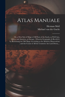
Atlas Manuale: or, a New Sett of Maps of All Parts of the Earth, as Well Asia, Africa, and America, as Europe; Wherein Geography is R (Paperback or Softback)
Publicado por Legare Street Press 9/9/2021, 2021
ISBN 10: 1014812259ISBN 13: 9781014812254
Librería: BargainBookStores, Grand Rapids, MI, Estados Unidos de America
Valoración del vendedor:

Libro
Paperback or Softback. Condición: New. Atlas Manuale: or, a New Sett of Maps of All Parts of the Earth, as Well Asia, Africa, and America, as Europe; Wherein Geography is R 0.62. Book.
Más opciones de compra de otros vendedores en IberLibro
Nuevo desde EUR 20,74
-
![Imagen del vendedor de Atlas Minor [cartographic Material]: or a New and Curious Set of Sixty-two Maps, in Which Are Shewn All the Empires, Kingdoms, Countries, States, in A (Paperback or Softback) a la venta por BargainBookStores](https://pictures.abebooks.com/inventory/md/md31241128212.jpg)
Atlas Minor [cartographic Material]: or a New and Curious Set of Sixty-two Maps, in Which Are Shewn All the Empires, Kingdoms, Countries, States, in A (Paperback or Softback)
Publicado por Legare Street Press 9/9/2021, 2021
ISBN 10: 1014766664ISBN 13: 9781014766663
Librería: BargainBookStores, Grand Rapids, MI, Estados Unidos de America
Valoración del vendedor:
Libro
Paperback or Softback. Condición: New. Atlas Minor [cartographic Material]: or a New and Curious Set of Sixty-two Maps, in Which Are Shewn All the Empires, Kingdoms, Countries, States, in A 0.75. Book.
Más opciones de compra de otros vendedores en IberLibro
Nuevo desde EUR 22,58
-
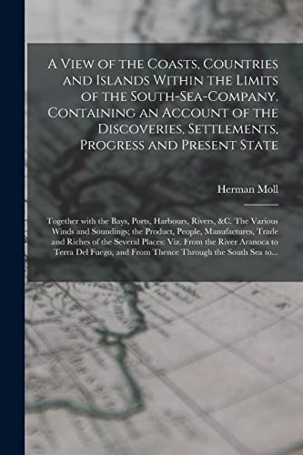
A View of the Coasts, Countries and Islands Within the Limits of the South-Sea-Company. Containing an Account of the Discoveries, Settlements, Progress and Present State; Together With the Bays, Ports, Harbours, Rivers, &c. The Various Winds And.
Publicado por Legare Street Press, 2021
ISBN 10: 1015195164ISBN 13: 9781015195165
Librería: THE SAINT BOOKSTORE, Southport, Reino Unido
Valoración del vendedor:
Libro Impresión bajo demanda
Paperback / softback. Condición: New. This item is printed on demand. New copy - Usually dispatched within 5-9 working days.
-
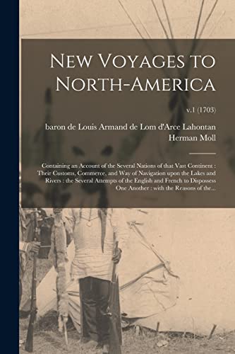
New Voyages to North-America: Containing an Account of the Several Nations of That Vast Continent : Their Customs, Commerce, and Way of Navigation . and French to Dispossess One Another :.;
Publicado por Legare Street Press 2021-09-09, 2021
ISBN 10: 1014647673ISBN 13: 9781014647672
Libro
Paperback. Condición: New.
-
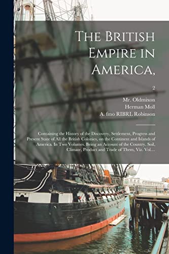
The British Empire in America,: Containing the History of the Discovery, Settlement, Progress and Present State of All the British Colonies, on the . Account of the Country, Soil, Climate,.; 2
Publicado por Legare Street Press 2021-09-10, 2021
ISBN 10: 1015350984ISBN 13: 9781015350984
Libro
Paperback. Condición: New.
-
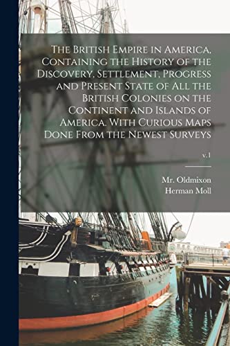
The British Empire in America, Containing the History of the Discovery, Settlement, Progress and Present State of All the British Colonies on the . Maps Done From the Newest Surveys; v.1
Publicado por Legare Street Press 2021-09-10, 2021
ISBN 10: 1015129978ISBN 13: 9781015129979
Libro
Paperback. Condición: New.
-
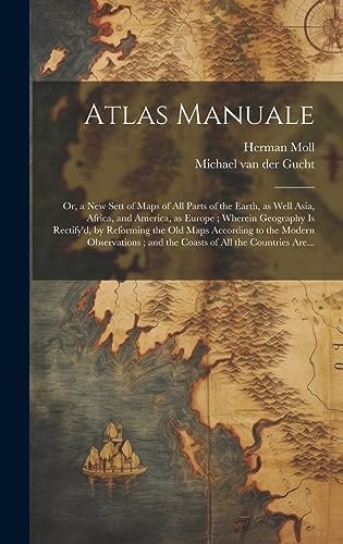
Atlas Manuale: or, a New Sett of Maps of All Parts of the Earth, as Well Asia, Africa, and America, as Europe; Wherein Geography is Rectify'd, by Reforming the Old Maps According to the Modern Observations; and the Coasts of All the Countries Are.
Publicado por Legare Street Press, 2023
ISBN 10: 1020517743ISBN 13: 9781020517747
Librería: THE SAINT BOOKSTORE, Southport, Reino Unido
Valoración del vendedor:
Libro Impresión bajo demanda
Hardback. Condición: New. This item is printed on demand. New copy - Usually dispatched within 5-9 working days.
-
![Imagen de archivo de Atlas Minor [cartographic Material]: or a New and Curious Set of Sixty-two Maps, in Which Are Shewn All the Empires, Kingdoms, Countries, States, in All the Known Parts of the Earth; With Their Bounds, Divisions, Chief Cities & Towns, the Whole. a la venta por THE SAINT BOOKSTORE](https://pictures.abebooks.com/isbn/9781019702154-es-300.jpg)
Atlas Minor [cartographic Material]: or a New and Curious Set of Sixty-two Maps, in Which Are Shewn All the Empires, Kingdoms, Countries, States, in All the Known Parts of the Earth; With Their Bounds, Divisions, Chief Cities & Towns, the Whole.
Publicado por Legare Street Press, 2023
ISBN 10: 101970215XISBN 13: 9781019702154
Librería: THE SAINT BOOKSTORE, Southport, Reino Unido
Valoración del vendedor:
Libro Impresión bajo demanda
Hardback. Condición: New. This item is printed on demand. New copy - Usually dispatched within 5-9 working days.
-
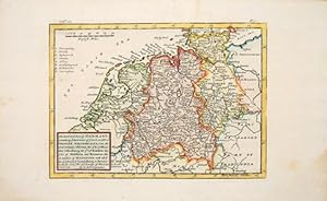
The North West Part of Germany.
Publicado por London: 1744, 1744
Librería: Peter Harrington. ABA/ ILAB., London, Reino Unido
Miembro de asociación: ABA ILAB PBFA
Valoración del vendedor:
Map of north-west Germany including the Netherlands, taken from Salmon's Modern History. Size: 250 x 175 mm. Copper engraving. Later colour. Very good condition, good margins. Minor discolouration to margins.
-
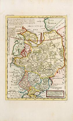
RUSSIA or MUSCOVY
Publicado por from Salmon's Modern History. 1744, 1744
Librería: Peter Harrington. ABA/ ILAB., London, Reino Unido
Miembro de asociación: ABA ILAB PBFA
Valoración del vendedor:
Map of European Russia. With geographical and historical notes on the map Copper engraving. Later colour. Very good condition, good margins Size: 19.3 x 26 cm. (7˝ x 10 inches).
-
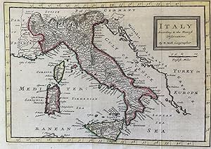
ITALY ACCORDING TO THE NEWEST OBSERVATIONS,
Librería: Sephora di Elena Serru, Foligno, Italia
Miembro de asociación: IOBA
Valoración del vendedor:
Titolo: Italy according to the Newest Observations Autore: Herman Moll (1654-1732) Data: 1740 circa Dimensioni del foglio: 290 x 215 mm. Dimensioni dell'incisione alla battuta: 257 x 182 mm. Tecnica: incisione su rame acquarellata a mano Condizioni generali: Ottime condizioni. Piegature. Herman Moll di orgine incerta (Germania o Provincie Unite) si stabilě a Londra dove iniziň la produzione di mappe sia sciolte che raccolte in atlanti. A Londra frequentava spesso Il Jonathan's Coffehouse dove conobbe lo scienziato Robert Hooke, gli scrittori Daniel Defoe, Jonathan Swift, i pirati William Dampier, William Hacke e Woodes Rogers e l'archeologo William Stukeley.Title: Italy according to the Newest Observations Author: Herman Moll (1654-1732) Date: 1740 circa Size of the page: 290x215 mm. Size of the engraving: 257x182 mm. Technique: copper engraving coloured by hand Conditions: Very good conditions. Foldings Herman Moll of uncert origin (Germany or United Provinces) established in London where he began the production of loosen maps or collected in Atlas. In London he frequently visited the Jonathan's Coffehouse where he knew the scientist Robert Hooke, the writers Daniel Defoe, Jonathan Swift, the pirates William Dampier, William Hacke e Woodes Rogers and the archeologist William Stukeley.
-

Persia.
Publicado por London, 1701
Librería: Alexandre Antique Prints, Maps & Books, Toronto, ON, Canada
Miembro de asociación: ABAC ILAB
Valoración del vendedor:

Mapa
Condición: Very Good; narrow right margin. For the shape of the Caspian Sea, Moll follows Olearius, distancing himself from the 17th century Dutch tradition of depicting it in oval shape. The boundaries of the provinces are clearly marked. It was published during the reign of the Safavid dynasty. , Size : 173x188 (mm), 6.81x7.40 (Inches), Hand Colored in Outline, 0.
-
Africa
Publicado por c.1729, London, 1729
Librería: Alexandre Antique Prints, Maps & Books, Toronto, ON, Canada
Miembro de asociación: ABAC ILAB
Valoración del vendedor:
Mapa
Condición: Very Good. Map of Africa, by Herman Moll published in Atlas minor. , Size : 202x275 (mm), 7.95x10.83 (Inches), Hand Colored.
-
New England, New York, New Jersey, and Pensilvania & c.
Publicado por c.1708, London, 1708
Librería: Alexandre Antique Prints, Maps & Books, Toronto, ON, Canada
Miembro de asociación: ABAC ILAB
Valoración del vendedor:
Mapa
Condición: Very Good. Detailed and rare map of Northeast part of the United States before the Independence (French English Wars period)., Size : 184x262 (mm), 7.24x10.31 (Inches), Black & White.
-
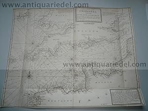
Channel,anno 1730, Moll Herman
Publicado por Moll Herman, 1654-1732, 1730
Librería: Hammelburger Antiquariat, Hammelburg, Alemania
Valoración del vendedor:

Mapa
Kein Einband. Condición: Gut. Channel,anno 1730, Moll Herman Coppermap, edited by Herman Moll, anno 1730, good condition, size of the leaf: 45 x 57 cm., good condition.
-
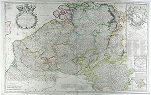
A New & Exact Map of the Electorate of Brunswick -Lunenburg and ye rest of ye Kings Dominions in Germany.
Publicado por J. & T. Bowles c.1720, London, 1720
Librería: Alexandre Antique Prints, Maps & Books, Toronto, ON, Canada
Miembro de asociación: ABAC ILAB
Valoración del vendedor:
Mapa
Large and detailed map of Germany by Herman Moll (1654-1732). It has a large and very decorative cartouche. With two inset maps: The Dutche of Saxon Lauwenburg. A Map of Part of England, the United Provinces, Westphalia and the Dominions of the King of Great Britain in Germany, shewing the Route of the Kings Journey from Hannover to Greenwich & c., Size : 620x1022 (mm), 24.41x40.24 (Inches), Hand Colored Very Good, with some skillful restorations; backed on acid free tissue paper for long term preservation.
-
Les Provinces Des Pays-Bas Catholiques ou A Most Exact Map of Flanders or ye Austrian Netherlands & c.
Publicado por J. & T. Bowles c.1720, London, 1720
Librería: Alexandre Antique Prints, Maps & Books, Toronto, ON, Canada
Miembro de asociación: ABAC ILAB
Valoración del vendedor:
Mapa Ejemplar firmado
Large and detailed map of the Netherlands by Herman Moll (1654-1732). It referrers to the Austrian Netherlands; Austria was given the Netherlands in the treaty of Utrecht (signed in 1712). The map has three inset maps: A Plan of all manner of works used in Fortification with the method of an Attack. A Map of the Roads from Paris to Valenciene. The South Part of Luxembourgh., Size : 617x1002 (mm), 24.29x39.45 (Inches), Hand Colored Very Good, backed on original linen.
-
Les Provinces Des Pays-Bas Catholiques ou A Most Exact Map of Flanders or Austrian Netherlands & c.
Publicado por Sold by H. Moll over against Devereux Court . D. Midwinter . & T. Bowles, London, 1715
Librería: Donald A. Heald Rare Books (ABAA), New York, NY, Estados Unidos de America
Miembro de asociación: ABAA ILAB
Valoración del vendedor:
Mapa
Copper-engraving, with outline period hand-colouring, on two joined sheets, overall sheet size: 24 3/4 x 41inches. Good condition apart from a few small expertly repaired tears. A fine large format map inspired by the War of the Spanish Succession, and showing the 'Austrian' Netherlands as they stood following the treaty of Utrecht in 1713. This fascinating map can be dated to after the treaty of Utrecht (which was signed in 1712) as this was when Austria was given the Netherlands and they are designated the 'Austrian Netherlands' in the title. The 'no-later than' date is based on the assumption that Moll would have removed the Duke of Ormond as the dedicatee very soon after his impeachment in June 1715 for siding with the Jacobins. In addition to the main map, the engraved area also includes three smaller 'vignettes': one a small scale map of the main roads to Paris from the north, the second an extension of an area on the main map, and a final image, with a key beneath, that attempts to explain the various 'works used in Fortification with the method of an Attack' Herman Moll came to London around 1678 from either Holland or Germany. He found work as a cartographical engraver, working for Moses Pitt, among others. By 1688 he had his own shop. Moll had a gift for making interesting friends and these included Daniel Defoe, Jonathan Swift (he provided "maps" for Robinson Crusoe and for Gulliver's Travels), William Dampier and Woodes Rogers, explorer-buccaneers and Robert Hooke, the scientist.
-
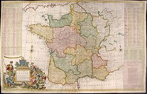
A New and Exact Map of France Dividid into all its Provinces and Acquisitions, according to the Newest Observations, and that accurate Survey made by the King's Command by Mr. Picar and de la Hire, with the Post Roads and the Computed Leagues from Town to Town, and the Passes of the Pirenean Mountains and many other Remarcks &c
Publicado por J. Bowles, P. Overton, T. Bowles, John King, London, 1740
Librería: Donald A. Heald Rare Books (ABAA), New York, NY, Estados Unidos de America
Miembro de asociación: ABAA ILAB
Valoración del vendedor:
Mapa
Hand-coloured engraving. Repaired loss to bottom left corner outside neat line with facsimile border. Trimmed to platemark in places in top margin. Three vertical creases where map was folded into atlas. Multiple creases parallel to center fold. Splits in vertical folds have been rebacked. A superb map of France during the reign of Louis XV. This large, marvellous Moll map of France bears his distinctive style and the fruits of his diligence. There is a lengthy, alphabetical index of more than 280 towns giving their distances from Paris as well as names and locations of passes through the Pyrenees. The source for this information was Nicolas de Fer. The depiction of France itself includes the roads and the distances from point to point on those roads in leagues, a relatively new feature in maps. Also noted, by a sword and date, are battle sites in which the English were involved or "mentioned in History" as he puts it. The cartouche includes two emblematic figures dressed for battle, one, Bacchus perhaps, the god of wine, and one loosely draped in a cloth adorned with fleur-de-lys who seems to represent French Royalty and, indirectly, French culture.
-
A New & Exact Map of the Electonate of Brunswick-Lunenburg and ye rest of ye Kings Dominion in Germany
Publicado por H. Moll, T. & J. Bowles, P. Overton & J. King, London, 1730
Librería: Donald A. Heald Rare Books (ABAA), New York, NY, Estados Unidos de America
Miembro de asociación: ABAA ILAB
Valoración del vendedor:
Mapa
Copper-engraved map, with original outline colour, in excellent condition. A magnificent map celebrating the ascension of the House of Hanover to the British throne, depicting the new King's German possessions. Herman Moll first printed this map immediately after George I came to the throne of Great Britain. Queen Anne (Stuart) died without heir, and after the legislated exclusion of her close, but Catholic, relatives, her distant Protestant cousin, the Elector of Hanover, was deemed to be her legitimate heir. It is amusing to note that even though George I ruled from 1714 to 1728, it is said that he never learned to speak more than a few words of the "King's English." This map principally focuses on the large region of northern Germany that was ruled by George, one of the princes of the Holy Roman Empire. As depicted on the map, this realm included the great port of Hamburg, as well as the important cities of Lünenberg and Hanover, and the university town of Göttingen. As noted in the lines and table in the lower-right of the map, this domain contained vast natural wealth, including numerous forests and 110 mines which yielded vast quantities of silver. A cartographic inset in the upper left details the Elector's newest possession, the Duchy of Saxon Lauwenberg. The inset to the upper left depicts the King's triumphal route through the North Sea from Hamburg to London. This grand composition is finished by a spectacular title cartouche featuring all manner of armaments, surmounted by the Royal coat of arms. The King was so delighted by Moll's finished manuscript that he awarded the fellow German "a Gold Medal" as a "mark of his Royal Favour." The present map was part of Herman Moll's magnificent folio work, a New and Compleat Atlas. Moll was the most important cartographer working in London during his era, a career that spanned over fifty years. His origins have been a source of great scholarly debate; however, the prevailing opinion suggests that he hailed from the Hanseatic port city of Bremen, Germany. Joining a number of his countrymen, he fled the turmoil of the Scanian Wars for London, and in 1678 is first recorded as working there as an engraver for Moses Pitt on the production of the English Atlas. It was not long before Moll became a charter member of London's most interesting social circle, which congregated at Jonathan's Coffee House at Number 20 Exchange Alley, Cornhill. It was at this establishment that speculators met to trade equities (most notoriously South Sea Company shares). Moll's coffeehouse circle included the scientist Robert Hooke, the archaeologist William Stuckley, the authors Jonathan Swift and Daniel Defoe, and the intellectually-gifted pirates William Dampier, Woodes Rogers and William Hacke. From these friends, Moll gained a great deal of privileged information that was later conveyed in his cartographic works, some appearing in the works of these same figures. Moll was highly astute, both politically and commercially, and he was consistently able to craft maps and atlases that appealed to the particular fancy of wealthy individual patrons, as well as the popular trends of the day. In many cases, his works are amongst the very finest maps of their subjects ever created with toponymy in the English language. Shirley, Maps in the Atlases of the British Library I, T.Moll-4b, 20; Cf. Reinhartz, The Cartographer and the Literati: Herman Moll and his Intellectual Circle.
-
A New Map of the Upper Part of Italy Containing ye Principality of Piemont ye Dutchies of Savoy, Milan, Parma, Mantua, Modena, Tuscany, the Dominions of ye Pope &c. The Republics of Venice, Genoa, Lucca & c.
Publicado por J. & T. Bowles c.1720, London, 1720
Librería: Alexandre Antique Prints, Maps & Books, Toronto, ON, Canada
Miembro de asociación: ABAC ILAB
Valoración del vendedor:
Mapa
Large and detailed map of Northern Italy by Herman Moll (1654-1732). It has plans of Venice, Mantua, Milan, Turin, Genoa, Placenza, Parma, Modena, Florenza, Rome and Civita Vecchia; plus A Prospect of the Town and Harbour of Leghorn., Size : 626x1040 (mm), 24.65x40.94 (Inches), Hand Colored Very Good, with some skillful restorations; backed on acid free tissue paper for long term preservation.
-
A New and Exact Map of the United Provinces, or Netherlands & c.
Publicado por J. & T. Bowles c.1720, London, 1720
Librería: Alexandre Antique Prints, Maps & Books, Toronto, ON, Canada
Miembro de asociación: ABAC ILAB
Valoración del vendedor:
Mapa
Large and detailed map of the Netherlands by Herman Moll (1654-1732).With inset plans and views of Amsterdam, Rotterdam, Middleburg, Utrecht, Groningen and The Late King William's Pallace called T'Loo., Size : 628x1035 (mm), 24.72x40.75 (Inches), Hand Colored Very Good, with some skillful restorations; backed on acid free tissue paper for long term preservation.
-
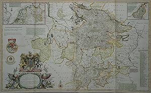
A New & Exact Map of the Electorate of Brunswick-Lunenburg
Ańo de publicación: 1720
Librería: Kunstantiquariat Andreas Senger, Hamburg, Alemania
Valoración del vendedor:
Mapa
Kein Einband. Condición: Gut bis sehr gut. Es handelt sich hierbei um eine originale, altkolorierte Kupferstich-Landkarte des Herzogtums Braunschweig - Lüneburg von Herman Moll, etwa aus dem Jahr 1720. *** Titel: A New & Exact Map of the Electorate of Brunswick-Lunenburg *** Gebiet bzw. Ort: Herzogtum Braunschweig - Lüneburg *** Kartograph: Herman Moll (1654 - 1732) *** Jahr: um 1720 *** Größe des Plattenbereichs: 61 x 101 cm *** Technik: Kupferstich *** Zustand (Perfekt/ Sehr gut/ Gut/ Ordentlich/ Mäßig/ Schlecht): In sehr gutem Erhaltungszustand - Mittelfalte hinterlegt. Oben knapprandig. Insgesamt befindet sich die Karte in einem für das große Format außergewöhnlich guten Erhaltungszustand. *** Bemerkungen: Diese seltene und großformatige Karte zeigt sehr detailliert das Herzogtum Braunschweig - Lüneburg unter König Georg I. Die altkolorierte, sehr dekorative Karte wird ergänzt durch zwei Insetkarten der Niederlande und Lauenburgs sowie einige Wappen und eine sehr aufwendig gestaltete Kartusche. *** English decription: This large and magnificently detailed map of the Duchy of Brunswick-Lüneburg by Herman Moll shows a very fine and decorative depiction of the area during the reign of George I. An interesting and desirable work in original colours that is rarely seen on the market. - - - International buyers welcome. If you have any questions, please don't hesitate to ask. --- Auf Wunsch stellen wir Ihnen gerne ein kostenfreies Echtheitszertifikat aus --- If you wish, we will gladly provide a certificate of authenticity free of charge ---.
-
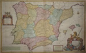
A New and Exact Map of Spain & Portugal Divided into its Kingdoms and Principalities & c. . . . 1711
Ańo de publicación: 1720
Librería: Kunstantiquariat Andreas Senger, Hamburg, Alemania
Valoración del vendedor:
Arte / Grabado / Póster
Kein Einband. Condición: Befriedigend. Ohne Schutzumschlag. Es handelt sich hierbei um eine originale, altkolorierte Kupferstich-Landkarte Spaniens und Portugals von Herman Moll, etwa aus dem Jahr 1720. *** Titel: A New and Exact Map of Spain & Portugal Divided into its Kingdoms and Principalities &c. . . . 1711 *** Gebiet bzw. Ort: Spanien, Portugal *** Kartograph: Herman Moll (1654 - 1732) *** Jahr: um 1720 *** Größe des Plattenbereichs: 61 x 98 cm *** Technik: Kupferstich *** Zustand (Perfekt/ Sehr gut/ Gut/ Ordentlich/ Mäßig/ Schlecht): In noch ordentlichem Erhaltungszustand - Rückseitig hinterlegt, knapprandig, restaurierte Randeinrisse am linken und rechten Rand, etwas gewellt. Moderate Bräunungen in einigen Bereichen. Insgesamt befindet sich die Karte in einem für das große Format ordentlichen Erhaltungszustand. *** Bemerkungen: Diese seltene und großformatige Karte zeigt sehr detailliert die iberische Halbinsel mit den vorgelagerten Mittelmeerinseln. Die altkolorierte, sehr dekorative Karte wird ergänzt durch einen Meilenanzeiger und zwei aufwendig gestaltete Kartuschen. ***** English description: This large and scarce map of Spain and Portugal shows a decorative and very detailed depiction of the Iberian peninsula in original colours. It was published by Herman Moll around 1720. The genuine copper engraving measures 61 x 98 cm (platesize) and is in fair condition. The map has been backed with thin Japanese paper and two horizontal tears in the left and right margin have been restored. There is some browning and waviness of the paper. Considering the large size and it's age of 300 years, the map is in a fair condition overall. --- International buyers welcome. If you have any questions, please don't hesitate to ask. --- Auf Wunsch stellen wir Ihnen gerne ein kostenfreies Echtheitszertifikat aus --- If you wish, we will gladly provide a certificate of authenticity free of charge ---.
-
A New Map of Great Britain
Publicado por J. & T. Bowles c.1720, London, 1720
Librería: Alexandre Antique Prints, Maps & Books, Toronto, ON, Canada
Miembro de asociación: ABAC ILAB
Valoración del vendedor:
Mapa
An early 18th century large and detailed map of Great Britain by Herman Moll (1654-1732)., Size : 1030x617 (mm), 40.55x24.29 (Inches), Hand Colored Very Good, with some skillful restorations; backed on acid free tissue paper for long term preservation.
-

Mapa Antiguo - Old Map : A New and Exact MAP of SPAIN & PORTUGAL, Divided into its Kingdoms and Principalities
Publicado por London, 1711
Librería: LIBRERÍA MAESTRO GOZALBO, Carcaixent, Espańa
Valoración del vendedor:
Mapa
1 lámina sin enmarcar Buen estado, pequeńa rotura margen inferior Divided into its Kingdoms and Principalities with Principal Roads and considerable improvements, the Whole rectifyd according to Newest Observations by H. Moll Geographer 1711 To His Grace John Duke of Argile. General of Her Majestys Forces in Spain. Estampado para el Atlas Geographicus: or a compleat system of geography. publicado en Londres entre los ańos 1711 y 1717. Demarcaciones en color. Coloreado a mano. Buen estado, pequeńa rotura margen inferior.
-
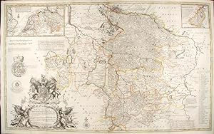
A New & Exact Map of the Electorate of Brunswick-Lunenburg and ye rest of ye Kings Dominions in Germany, Very much Improved by ye kind Assistance of severall Curious Gentlemen, natives of those Countries. To His Most Sacred Majesty George King of Great Britain, France and Ireland, Elector of Brunswick-Lunenburg &c
Publicado por Herman Moll and Philip Overton, London, 1740
Librería: Donald A. Heald Rare Books (ABAA), New York, NY, Estados Unidos de America
Miembro de asociación: ABAA ILAB
Valoración del vendedor:
Mapa
Hand-coloured engraving. Creased vertically where map was folded into atlas. Moll's Map of King George I's dominions in Germany. Brunswick-Lunenburg had been ruled by one family, descendants of Guelph, since the 13th century. One branch of this ancient family brought forth the Hanoverian Kings of Great Britain. It was the first of these Kings, George I, who was "so highly - pleased with this Map, that he Presented the Author with a Gold Medal, &c. as a mark of his Royal Favour, and approbation of the Performance." The map is, of course, dedicated to the King, and it is almost certainly the first English map of the recently crowned King's homeland. With a large Royal Coat of Arms, a striking, militaristic cartouche, an inset map of King George's route from Harburg to Greenwich, and an inset of Saxon Lauwenburg (recently added to the King's German dominions), Moll celebrates the King's ancestral homeland. He includes as well a numbered index of 50 forests and mentions several major silver mines. "These Mines bring a great yearly Revenue to his Majesty." Herman Moll came to London in about 1678 from Germany or Holland and worked as an engraver for Moses Pitt, among others. He clearly had a talent for making interesting friends and provided maps for Daniel Defoe's Robinson Carusoe and Jonathan Swift's Gulliver's Travels. He also knew explorer/buccaneer William Dampier and the chemist Robert Boyle. From 1689, he had his own London shop. Maps of a uniquely Moll character began to appear during Queen Anne's reign, and his individual style of mapmaking grew increasingly more distinct as his career progressed. Dictionary of National Biography.
-
To the Right Honorable Charles Earl of Sunderland, and Baron Spencer of Wormleighton . this Map of South America, According to the Newest and Most Exact Observations is Most Humbly Dedicated.
Publicado por J. & T. Bowles c.1720, London, 1720
Librería: Alexandre Antique Prints, Maps & Books, Toronto, ON, Canada
Miembro de asociación: ABAC ILAB
Valoración del vendedor:
Mapa
Large and detailed map of South America by Herman Moll (1654-1732). With an inset showing Potosi in Bolivia., Size : 598x990 (mm), 23.54x38.98 (Inches), Hand Colored Very Good, with some skillful restorations; backed on acid free tissue paper for long term preservation.
-
To the Right Honourable Charles Earl of Peterborow, and Monmouth, &c., This Map of Africa, According to ye newest and most exact observations.
Publicado por J. & T. Bowles c.1720, London, 1720
Librería: Alexandre Antique Prints, Maps & Books, Toronto, ON, Canada
Miembro de asociación: ABAC ILAB
Valoración del vendedor:
Mapa
Detailed map of Africa by Herman Moll (1654-1732). A large decorative cartouche in upper right corner depicts natives and wildlife. In the lower left, an inset depicting Cape Coast Castle, James Fort, and the Fort of Good Hope. In the lower right, another inset depicting a view of the Cape of Good Hope. "An unusual feature of the Moll map is a ship's course from England to Surat with engraved lines showing the direction of the winds and arrows indicating the monsoons." (Tooley Africa), Size : 582x972 (mm), 22.91x38.27 (Inches), Hand Colored, 0 Very Good, with some skillful restorations.
-
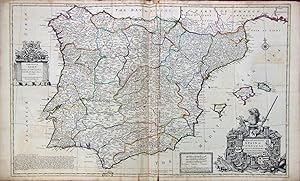
Mapa Antiguo - Old Map : A New and Exact MAP of SPAIN & PORTUGAL, Divided into its Kingdoms and Principalities
Publicado por London, 1711
Librería: LIBRERÍA MAESTRO GOZALBO, Carcaixent, Espańa
Valoración del vendedor:
Mapa
Condición: Buen estado. 1 lámina sin enmarcar Buen estado Divided into its Kingdoms and Principalities with Principal Roads and considerable improvements, the Whole rectifyd according to Newest Observations by H. Moll Geographer 1711 To His Grace John Duke of Argile. General of Her Majestys Forces in Spain. Estampado para el Atlas Geographicus: or a compleat system of geography. publicado en Londres entre los ańos 1711 y 1717. Demarcaciones en color. Coloreado a mano.