Importe total (1 artĒculo artĒculos):
Destino del pedido:

mercator gerard 1512 1594 and jodocus hondius 1563 1611 (5 resultados)
Ir a los resultados principales
Tipo de artĒculo
- Todo tipo de artĒculos
- Libros (4)
- Revistas y publicaciones
- C¾mics
- Partituras
- Arte, grabados y p¾sters
- FotografĒas
- Mapas (1)
-
Manuscritos y
coleccionismo de papel
Condici¾n
- Todo
- Nuevos
- Antiguos o usados
Encuadernaci¾n
- Todo
- Tapa dura (1)
- Tapa blanda
Mßs atributos
- Primera edici¾n (3)
- Firmado
- Sobrecubierta
- Con imßgenes del vendedor (4)
- Sin impresi¾n bajo demanda
Ubicaci¾n del vendedor
Valoraci¾n de los vendedores
-
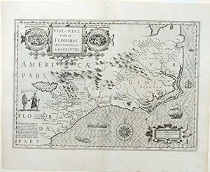
Virginiae item et Floridae Americae provinciarum nova descriptio
Publicado por Hondius-Janssonius, [Amsterdam, 1623
Librería: Donald A. Heald Rare Books (ABAA), New York, NY, Estados Unidos de America
Miembro de asociaci¾n: ABAA ILAB
Valoraci¾n del vendedor:

Mapa
Copper-plate engraving. Centerfold strengthened, repaired tear upper margin, otherwise excellent. One of the great early maps of the American South, from before the Jamestown colony. The Mercator-Hondius map of Virginia and Florida, first published in 1606 by Jodocus Hondius, was the only regional American map in his edition of the Mercator Atlas. It is a remarkably good rendition of the coastline from St. Augustine to the Chesapeake Bay and points interior. Derived from John White's map of Virginia (what became North Carolina), Le Moyne-De Bry's map of Florida (what became South Carolina, Georgia and north Florida) and early travel accounts, Hondius cobbled together a map of great interest. On the coast one finds a roughly accurate northeasterly shoreline from the Spanish fort of St. Augustine to the St. John's River (here called R. de May) where the second unsuccessful Huguenot colony struggled in 1564, upward to Port Royal, where the first unsuccessful Huguenot colony failed in 1562, upward to Cape Fear (here Cape St. Romano) to the Outer Banks and finally to the clearly as yet unexplored Chesapeake Bay. Of the interior, rumor contends with pure fiction, but the source of many rivers is the "Apalatcy" mountain range, which also promises gold and silver. The South Carolina-Georgia portion of the interior is much more heavily notated with native villages, probably impossible at this point to verify. The map is embellished with illustrations borrowed from Le Moyne and White, including native towns, a native king and queen and a canoe. The title cartouche is a handsome three part figure with the two village illustrations on either side of the title. Koeman Me27A; Cumming, 26 (pl.20); Burden 151; Goss, 23; Howgego L70 (LaudonniĶre), R36 (Ribault).
-
Atlas minor.
Publicado por Amsterdam: Jodocus Hondius and Jan Jansson,, 1607
Librería: Arader Galleries - AraderNYC, New York, NY, Estados Unidos de America
Valoraci¾n del vendedor:
Original o primera edici¾n
Oblong 4to., (6 4/8 x 8 5/8 inches). Engraved allegorical title-page (laid down), engraved allegorical plate, 149 (of 152) fine engraved maps, four of the Italian maps with later hand-colouring in outline, all with letterpress headline titles, printed on rectos with text on versos, woodcut initials (without maps 149 "Designatio orbis Christianis", 151 "Romani Imperii imag" and 152 " Alexandri Magni expeditio, one text leaf at the end, some early repairs to versos, map 146 "Topographia Paradisi" a bit stained and frayed). 17th- or 18th-century English reverse blind panelled calf ( a bit worn at the extremities). Provenance: with the ownership inscriptions and notes of Nicholas Pottinger dated 1642 and 1672 on the front free endpaper, and his table at the end including a list of "Peoples & Places of note whereto be found"; the early initials of "MF" on the front free endpaper; late 18th or early 19th-century ownership inscription of Philip Griffin, Warnford, Hampshire on the fifth blank, with his manuscript numbering to maps and interleaved; the modern bookplate of Lionel H. Pries on the front paste-down. First edition, and rare, of the Hondius-Mercator pocket atlas, and intended as a reduced version of Gerard Mercator's folio atlas "Atlas sive Cosmographia", 1606. Copies often show signs of rushed printing, with inserts or pasted-down leaves correcting impressions of the wrong copperplates: in this copy the maps of Morea (122) and Egypt (125) are correctly printed (unlike the copy described by Koeman), but map 58 was printed in duplicate, and map 54 printed on the wrong page. A second impression of map 58 "Lyonnois Forest et Beaujolais" misprinted on Ii4 in place of map 54 "Lotaringia septentrionale)", map 54 misprinted on Kk2 in place of map 55 "Lotaringia meridiona", a correct impression of map 55 supplied on an inserted leaf facing Ii4. This smaller atlas was a huge success for Hondius and his partners Cornelius Claesz and Johannes Janssonius, and editions were published not only in Latin, but also in French, Dutch, German and eventually in Russian, Turkish and English. Including a fine double-hemisphere world map "Typus Orbis Terrarum", "America", "Polus Arcticus", "Hispania Nova", "Virginia & Florida", "Cuba", "America Meridionalis", and "Fretum Magellanicum" relating to America. Koeman II Me 186. Catalogued by Kate Hunter.
-
Atlas minor.
Publicado por Amsterdam: Jodocus Hondius, [colophon:] Dordrecht: Adrianus Bottius, 1610
Librería: Arader Galleries - AraderNYC, New York, NY, Estados Unidos de America
Valoraci¾n del vendedor:
Oblong 4to, (7 x 9 inches). Engraved allegorical title-page (top and bottom margins trimmed, affecting the platemark at the bottom), allegorical engraving, and 153 fine engraved maps with titles in cartouches, all paginated, and with letterpress headline titles, printed on rectos with Latin text on versos and letterpress text printed on versos, woodcut printer's device on verso of last leaf (folios 4Q1 and 4Q4 repaired affecting the borders of maps 148 and 151, wormholes to folio T3, a few other minor marginal repairs, some occasional mostly marginal staining). Contemporary vellum over paste-board, yapp edges (paste-downs renewed). Provenance: with the ownership inscription of George Frideric Leyfert dated 1706 on the verso of the title-page, and of his tutor(?) M. Fr. W. Noldius. K. F.G.V.C; place-names on many maps underlined in early red ink. First published in 1607, the Hondius-Mercator pocket atlas, was intended as a reduced version of Gerard Mercator's folio atlas "Atlas sive Cosmographia", 1606. This smaller atlas was a huge success for Hondius and his partners Cornelius Claesz and Johannes Janssonius, and editions were published not only in Latin, but also in French, Dutch, German and eventually in Russian, Turkish and English. Including a fine double-hemisphere world map "Typus Orbis Terrarum", "America", "Polus Arcticus", "Hispania Nova", "Virginia & Florida", "Cuba", "America Meridionalis", "Fretum Magellanicum", and "Designatio Orbis Christiani" relating to America. Koeman II Me 189A; Phillips 429. Catalogued by Kate Hunter.
-
Atlas Minor, das ist ein kurtze jedoch grundtliche beschreibung der gantzen welt und aller ihrer theyl.
Publicado por [Amsterdam, 1609]., 1609
Librería: Arader Galleries - AraderNYC, New York, NY, Estados Unidos de America
Valoraci¾n del vendedor:
Original o primera edici¾n
Oblong 4to., (7 x 9 2/8 inches) Engraved title-page (from the first edition, Amsterdam 1607), allegorical plate depicting the three fates and 152 engraved maps, all with fine hand-color in full (lacking the printed German title-page and pages 5-7 "Ein kurtze.", engraved title-page torn and repaired with loss, allegorical plate and first 7 maps with marginal tears and other faults repaired, some heavy mostly marginal staining). Contemporary Dutch blind-stamped vellum (rebacked and soiled). First German edition of the "Atlas Minor", first published in Latin in Amsterdam in 1607, and intended as a reduced version of Gerard Mercator's folio atlas "Atlas sive Cosmographia", 1606. This smaller atlas was a huge success for Hondius and his partners Cornelius Claesz and Johannes Janssonius, and editions were published not only in Latin, and German as here, but also in French, Dutch, and eventually in Russian, Turkish and English. Including one map not published in the first edition "Cambria sive Wallia", and thirteen maps relating to America. Burden 153; Koeman II me 188; Philips 425.
-

Atlas, sive Cosmographicae Meditationes de Fabrica Mundi, et Fabricata Figura.
Publicado por Amsterdam: Jodocus Hondius, 1619., 1619
Librería: Arader Galleries - AraderNYC, New York, NY, Estados Unidos de America
Valoraci¾n del vendedor:
Original o primera edici¾n
5 parts in one volume (17 x 11 2/8 inches. Engraved allegorical general title-page, and 4 sectional title-pages, double-page double portrait of Mercator and Hondius, double-page engraved world map (Shirley 157, chipped with minor loss along a vertical crease), and 1554 double-page maps, and one full-page map, all with original hand-colour in outline an in part (map of America chipped with minor loss along a vertical crease, some small marginal repairs). Modern panelled pigskin over oak bevelled boards antique, brass clasps and catches. THE FIRST TRUE "ATLAS"-THE WORD CHOSEN BY GERARD MERCATOR TO DESIGNATE A COLLECTION OF MAPS AND ONLY LATER ADOPTED BY ALL GEOGRAPHERS Later edition of Mercator s celebrated "Atlas", published after Mercator s death by his son Rumold. For nearly sixty years, during the most important and exciting period in the history of modern mapmaking, Gerard Mercator was the supreme cartographer, his name, second only to Ptolemy, synonymous with the form of map projection still in use today. Although not the inventor of this type of projection, he was the first to apply it to navigational charts in such a form that compass bearings could be plotted on charts in straight lines, thereby providing seamen with a solution to an age-old problem of navigation at sea. The influence of his revolutionary ideas transformed land surveying, and his research and calculations led him to break away from Ptolemy's conception of the size and outline of the continents. Unlike the work of Abraham Ortelius, a contemporary and equally celebrated cartographer, Mercator's maps are original. While Ortelius engaged in the reduction and generalization of already existing maps, Mercator checked current knowledge of the earth's topography against its fundamental sources and drew maps in an original manner. Mercator was born in Rupelmonde in East Flanders. He studied in Louvain under Gemma Frisius, a Dutch astronomer and mathematician, and began his career as a cartographer in that city, where the excellence of his work eventually won him the patronage of Charles V. In order to escape religious persecution, he moved in 1552 to Duisburg. There, he continued to produce maps, globes and instruments, including his most celebrated work, a world map on eighteen sheets drawn to his new projection (1569). In later life he devoted himself to the preparation of his three-volume collection of maps to which, for the first time, the word "atlas" was applied. The word was chosen, he wrote, "to honor the Titan, Atlas, King of Mauritania, a learned philosopher, mathematician, and astronomer." Mercator's sons and grandsons were all cartographers and made their contributions in various ways to the great atlas. His son Rumold, in particular, was responsible for the complete edition of 1595. But Mercator's work only received the universal acclaim that it deserved when Jodocus Hondius bought the copper printing plates from the cartographer's heirs in 1604. In 1606 the first Amsterdam edition of the Mercator Atlas appeared. From then to 1638, the atlas saw many enlarged editions in various languages. Koeman Me 26B. Catalogued by Kate Hunter.