
Importe total (1 artículo artículos):
Destino del pedido:

mehmed abdulkadir beyin osman makram (1 resultados)
Ir a los resultados principales
Tipo de artículo
- Todo tipo de artículos
- Libros
- Revistas y publicaciones
- Cómics
- Partituras
- Arte, grabados y pósters
- Fotografías
- Mapas (1)
-
Manuscritos y
coleccionismo de papel
Condición
- Todo
- Nuevos
- Antiguos o usados
Encuadernación
- Todo
- Tapa dura
- Tapa blanda
Más atributos
- Primera edición
- Firmado
- Sobrecubierta
- Con imágenes del vendedor
- Sin impresión bajo demanda
Ubicación del vendedor
Valoración de los vendedores
-
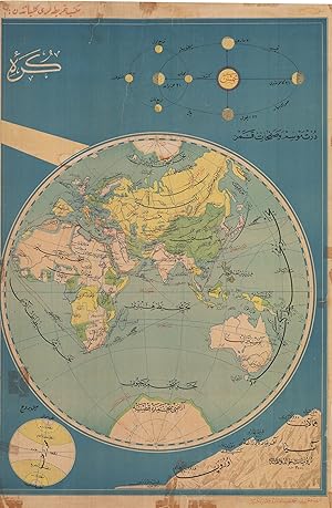
OTTOMAN CARTOGRAPHY / EASTERN HEMISPHERE
Publicado por Istanbul: Mektep Haritalari Külliyatindan / Printing Office of Documentary maps [circa ], 1910
Librería: Antiquariat Dasa Pahor GbR, München, Alemania
Miembro de asociación: ILAB VDA
Valoración del vendedor:

Mapa
Colour lithography, 96 x 63 cm (37.9 x 24.8 inches), (minor staining, tears repaired with modern tape and partly age-toned). A large map in Ottoman language represents the Eastern Hemisphere in the time around 1910. Marked are the major sea and train routes. The highest and most famous mountains of Asia, Africa and Europe, being Himalaya. Kilimanjaro, Mont Blanc and Vesuvius, are showcased in the lower right corner. They are compared to the elevation of the East European Plain (here marked as Russian Plain). The map was drafted by an Ottoman cartographer Mehmed Abdulkadir Beyin, who was known for his large scale maps, mostly printed in colour and published by Mektep Haritalari Külliyatindan (Printing office of documentary maps) for educational purposes.