
Importe total (1 artículo artículos):
Destino del pedido:

louisiana mouth mississippi (1 resultados)
Ir a los resultados principales
Tipo de artículo
- Todo tipo de artículos
- Libros
- Revistas y publicaciones
- Cómics
- Partituras
- Arte, grabados y pósters (1)
- Fotografías
- Mapas
-
Manuscritos y
coleccionismo de papel
Condición
- Todo
- Nuevos
- Antiguos o usados
Encuadernación
- Todo
- Tapa dura
- Tapa blanda
Más atributos
- Primera edición
- Firmado
- Sobrecubierta
- Con imágenes del vendedor
- Sin impresión bajo demanda
Ubicación del vendedor
Valoración de los vendedores
-
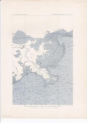
Alluviation-delta: Mouth of MIssissippi River.
Publicado por Washington, D.C.: Government Printing Office ,, 1908
Librería: Antiquariat Ruthild Jäger, Lueneburg, Alemania
Miembro de asociación: ILAB VDA
Valoración del vendedor:

Arte / Grabado / Póster
Lithography in two-colour-printing (black, blue), 20 x 28 cm (= 7 x 11 in). In very good state of conservation. (from U. S. Geological Survey, 1908). * The precisely engraved map shows the Mouth of the Mississippi River, from Lake Pontchartrain and New Orleans to Chandeleur Islands and to Bayou la Fourche; with water depth contours and topographic details. (#6115AG).