Importe total (1 artículo artículos):
Destino del pedido:

lesley j p w g platt j j (1 resultados)
Comentarios
Ir a los resultados principales
Filtros de búsqueda
Tipo de artículo
- Todos los tipos de productos
- Libros (1)
- Revistas y publicaciones (No hay ningún otro resultado que coincida con este filtro.)
- Cómics (No hay ningún otro resultado que coincida con este filtro.)
- Partituras (No hay ningún otro resultado que coincida con este filtro.)
- Arte, grabados y pósters (No hay ningún otro resultado que coincida con este filtro.)
- Fotografías (No hay ningún otro resultado que coincida con este filtro.)
- Mapas (No hay ningún otro resultado que coincida con este filtro.)
- Manuscritos y coleccionismo de papel (No hay ningún otro resultado que coincida con este filtro.)
Condición
- Todos los libros
- Nuevos (No hay ningún otro resultado que coincida con este filtro.)
- Antiguos o usados (1)
Encuadernación
- Todas
- Tapa dura (1)
- Tapa blanda (No hay ningún otro resultado que coincida con este filtro.)
Más atributos
- Primera edición (1)
- Firmado (No hay ningún otro resultado que coincida con este filtro.)
- Sobrecubierta (No hay ningún otro resultado que coincida con este filtro.)
- Con imágenes (1)
- No impresión bajo demanda (1)
Gastos de envío gratis
- Envío gratis a Espańa (No hay ningún otro resultado que coincida con este filtro.)
Valoración de los vendedores
-
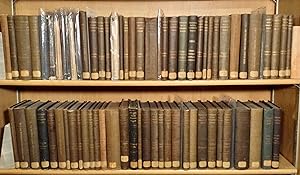
A SET OF 74 VOLUMES FROM THE SECOND GEOLOGICAL SURVEY OF PENNSYLVANIA, 1874-1891, INCLUDING 13 ATLASES; 200++ GEOLOGICAL MAPS, MANY COLORED. VOLUMES ARE FIRST EDITIONS IN ORIGINAL CLOTH BINDINGS.
Publicado por The State of Pennsylvania, 1874
Librería: Olde Geologist Books, Pawcatuck, CT, Estados Unidos de America
Miembro de asociación: SNEAB
Calificación del vendedor: 5 de 5 estrellas

Original o primera edición
Hardcover. Condición: Very Good. 1st Edition. Harrisburg, octavo, variously paged; hundreds of maps and illustrations. ***CONTENT: The Second Geological Survey of Pennsylvania, directed by J. Peter Lesley, State Geologist, is celebrated as "the most remarkable series of reports ever issued by any survey" (Merrill, 1924). Unprecedented in their quality, detail, and comprehensiveness, these reports provide a 'treasure trove' of geologic, economic and historic information about Pennsylvania and surrounding States during the 'Golden Age' of industrial growth and development in the mid-late 19th century. Then, Pennsylvania supplied much of the natural resources and manufactured commodities necessary for western expansion. Understandably, many of the volumes describe the abundant economic resources of the State: vast deposits of anthracite and bituminous coal, as well as oil and gas, iron ores, limestone and other industrial materials. Information is provided on mine locations, mining equipment and methods, transportation, etc. More than 40 of these volumes document the geology and resources of specific counties in Pennsylvania, including: Adams, Allegheny, Armstrong, Beaver, Bedford, Berks, Blair, Bradford, Bucks, Butler, Cambria, Cameron, Carbon, Centre, Clarion, Clearfield, Clinton, Cumberland, Dauphin, Delaware, Elk, Fayette, Forest, Franklin, Fulton, Greene, Huntingdon, Indiana, Jefferson, Juniata, Lancaster, Lawrence, Lehigh, McKean, Mercer, Mifflin, Monroe, Montgomery, Northampton, Perry, Philadelphia, Pike, Potter, Schuylkill, Snyder, Somerset, Susquehanna, Tioga, Union, Venango, Washington, Wayne, and Westmoreland, not to mention other areas and regions. Other volumes discuss the Permian and Carboniferous plant fossils of Pennsylvania and adjacent states, and Paleozoic invertebrate fossils: trilobites, eurypterids, brachiopods, corals, crinoids, etc. Several volumes describe the State's minerals, others report on chemical analyses, and three volumes catalogue the geological collections of the State Museum. There isn't much that these comprehensive volumes don't consider! Seven atlas volumes have maps of the "Anthracite fields"; other atlases show colored county geologic maps, etc. Most county reports have map pockets with maps, plus maps in the text and numerous figures. ***CONDITION: These volumes are in the original brown cloth covers, and most are in VERY GOOD or better condition, some are FINE. The original backstrips bear gilt lettering; a few of the atlas volumes are lacking their (flimsy) backstrips, and the covers are loose, but the maps are sound. The volume text pages and illustrations are typically near pristine: fresh, clean and bright, with no foxing or dampstains. The bindings are strong. The atlas maps and pocket maps are folded and are well preserved. Most of these volumes were deaccessioned from a New England library and have paper shelf labels on the lower spines, and small stamps on preliminary pages. I have not collated all the volumes, but I am confident that most, if not all, are fully complete. In my 50 years as a geologist, I have not seen a set of this size and quality offered for sale. Do not hesitate to contact me "Olde Geologist Books" with any questions. Domestic and international shipping will be extra, but only at my cost, about $100 for US addresses.