
Importe total (1 artículo artículos):
Destino del pedido:

john 1817 1876 tallis (106 resultados)
Ir a los resultados principales
Tipo de artículo
- Todo tipo de artículos
- Libros (34)
- Revistas y publicaciones
- Cómics
- Partituras
- Arte, grabados y pósters (72)
- Fotografías
- Mapas
-
Manuscritos y
coleccionismo de papel
Condición
Encuadernación
Más atributos
- Primera edición (4)
- Firmado
- Sobrecubierta
- Con imágenes del vendedor (102)
- Sin impresión bajo demanda (103)
Gastos de envío gratis
Ubicación del vendedor
Valoración de los vendedores
-

Tallis's Drawing Room Table Book of Theatrical Portraits, Memoirs and Anecdotes
Publicado por Legare Street Press, 2021
ISBN 10: 1014547911ISBN 13: 9781014547910
Librería: Lucky's Textbooks, Dallas, TX, Estados Unidos de America
Valoración del vendedor:

Libro
Condición: New.
Más opciones de compra de otros vendedores en IberLibro
Nuevo desde EUR 16,06
-
![Imagen del vendedor de John Tallis's London street views, 1838-1840 : together with the revised and enlarged views of 1847; introduced and with a biographical essay by Peter Jackson. (1969) [LeatherBound] a la venta por S N Books World](https://pictures.abebooks.com/inventory/md/md31650030258.jpg)
John Tallis's London street views, 1838-1840 : together with the revised and enlarged views of 1847; introduced and with a biographical essay by Peter Jackson. (1969) [LeatherBound]
Ańo de publicación: 2022
Libro Impresión bajo demanda
LeatherBound. Condición: New. Leatherbound edition. Condition: New. Leather Binding on Spine and Corners with Golden leaf printing on spine. Bound in genuine leather with Satin ribbon page markers and Spine with raised gilt bands. A perfect gift for your loved ones. Reprinted from 1969 edition. NO changes have been made to the original text. This is NOT a retyped or an ocr'd reprint. Illustrations, Index, if any, are included in black and white. Each page is checked manually before printing. As this print on demand book is reprinted from a very old book, there could be some missing or flawed pages, but we always try to make the book as complete as possible. Fold-outs, if any, are not part of the book. If the original book was published in multiple volumes then this reprint is of only one volume, not the whole set. IF YOU WISH TO ORDER PARTICULAR VOLUME OR ALL THE VOLUMES YOU CAN CONTACT US. Resized as per current standards. Sewing binding for longer life, where the book block is actually sewn (smythe sewn/section sewn) with thread before binding which results in a more durable type of binding. Pages: 322 Language: English Pages: 322.
-
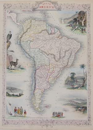
South America
Publicado por Artist: Tallis John ( - 1876 ) London ; issued in: London ; ca: 1840; - John Tallis was an English cartographic publisher His company John Tallis and Company published views maps and atlases in London from roughly 1838 to 1851, 1817
Librería: Antique Sommer& Sapunaru KG, München, Alemania
Miembro de asociación: ILAB VDA
Valoración del vendedor:

Technic: Lithography; colorit: original colored; condition: Very good, size (in cm): 34,5 x 24; - Map shows total South America with 7 pictures of country and population.
-
Tallis's history and description of the Crystal palace, and the Exhibition of the world's industry in 1851 / illustrated by beautiful steel engravings, from original drawings and daguerreotypes by Beard, Mayall, etc.
Publicado por London ; New York : J. Tallis and Co., 1852
Original o primera edición
1st edition. Poor copy in the original half aniline calf over cloth boards. Spine worn with some loss. Hinges starting. Spine bands and panel edges rubbed and bumped as with age. Text remains clear and without blemish. Physical description; 1 v., llustrations (some color), plates. Some plates missing. Subjects; Crystal Palace (Great Exhibition, 1851, London, England). Catalogs. Pictorial works. Expositions. Sciences. 1 Kg.
-

Tallis's history and description of the Crystal palace, and the Exhibition of the world's industry in 1851 / illustrated by beautiful steel engravings, from original drawings and daguerreotypes by Beard, Mayall, etc.
Publicado por London ; New York : J. Tallis and Co., 1852
Librería: MW Books, New York, NY, Estados Unidos de America
Valoración del vendedor:
Original o primera edición
1st edition. Poor copy in the original half aniline calf over cloth boards. Spine worn with some loss. Hinges starting. Spine bands and panel edges rubbed and bumped as with age. Text remains clear and without blemish. Physical description; 1 v., llustrations (some color), plates. Some plates missing. Subjects; Crystal Palace (Great Exhibition, 1851, London, England). Catalogs. Pictorial works. Expositions. Sciences. 1 Kg.
-
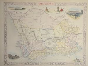
Cape Colony
Publicado por Artist: Tallis John ( - 1876 ) London ; issued in: London ; ca: 1840; - John Tallis was an English cartographic publisher His company John Tallis and Company published views maps and atlases in London from roughly 1838 to 1851, 1817
Librería: Antique Sommer& Sapunaru KG, München, Alemania
Miembro de asociación: ILAB VDA
Valoración del vendedor:
Technic: Lithography; colorit: original colored; condition: Very good, size (in cm): 24,5 x 32 cm; - Map shows the countries of south Africa with 6 representations of countries and population, also a view of Capetown.
-
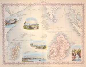
Isalnds in the Indian Ocean
Publicado por Artist: Tallis John ( - 1876 ) London ; issued in: London ; ca: 1840; - John Tallis was an English cartographic publisher His company John Tallis and Company published views maps and atlases in London from roughly 1838 to 1851, 1817
Librería: Antique Sommer& Sapunaru KG, München, Alemania
Miembro de asociación: ILAB VDA
Valoración del vendedor:
Technic: Lithography; colorit: original colored; condition: Very good, size (in cm): 25,5 x 34; - Map shows the Indian Ocaen with Madakascar and the Maledives, Mauritius on inset map. With 5 views of harbours and population.
-
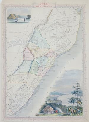
Natal and Kaffraria
Publicado por Artist: Tallis John ( - 1876 ) London ; issued in: London ; ca: 1840; - John Tallis was an English cartographic publisher His company John Tallis and Company published views maps and atlases in London from roughly 1838 to 1851, 1817
Librería: Antique Sommer& Sapunaru KG, München, Alemania
Miembro de asociación: ILAB VDA
Valoración del vendedor:
Technic: Lithography; colorit: original colored; condition: Very good, size (in cm): 35,5 x 24,5 cm; - Map shows Natal and Kafraria in south Africa with 2 beautiful views of Durban and Port Natal.
-
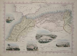
Northern Africa
Publicado por Artist: Tallis John ( - 1876 ) London ; ca: 1850; - John Tallis was an English cartographic publisher His company John Tallis and Company published views maps and atlases in London from roughly 1838 to 1851, 1817
Librería: Antique Sommer& Sapunaru KG, München, Alemania
Miembro de asociación: ILAB VDA
Valoración del vendedor:
Technic: Steel engraving; colorit: colored; condition: Very good, size (in cm): 25,5 x 33; - Map shows total North Africa with city views of Marocco, Constanine, Algiers and Tunis.
-
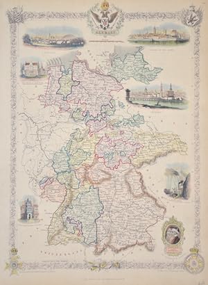
Germany
Publicado por Artist: Tallis John ( - 1876 ) London ; issued in: London ; ca: 1850; - John Tallis was an English cartographic publisher His company John Tallis and Company published views maps and atlases in London from roughly 1838 to 1851, 1817
Librería: Antique Sommer& Sapunaru KG, München, Alemania
Miembro de asociación: ILAB VDA
Valoración del vendedor:
Technic: Steel engraving; colorit: original colored; condition: Upper margin perfectly enlarged, size (in cm): 35 x 24 cm; - Map shows the whole of Germany with floral border and 5 coats of arms. Furthermore, six views, such as Coburg, Cologne, Dresden and the silver mine in the Hartz.; - Special feature: Germany with 6 views , Cologne, Coburg ect.
-
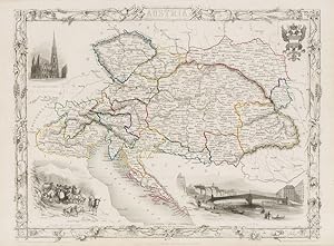
Austria - With Vignettes of Vienna, Return of the Sennerin, and St. Stephen's, Vienna.
Publicado por London, Edinburgh & Dublin, J & F. Tallis., 1851
Librería: Inanna Rare Books Ltd., Skibbereen, CORK, Irlanda
Valoración del vendedor:
Arte / Grabado / Póster
Original steel engraving / Vintage map. Drawn and engraved by John Rapkin. Partly hand-coloured. Illustrations by H. Warren and Engraved by J.H. Kernot. Plate Size: 33 cm x 25.5 cm. Sheet Size: 37.5 cm x 27.2 cm. Vintage 19th century map in very good condition. Beautiful map of Austria with gorgeous illustrated vignettes from the Victorian publisher. This is the Austria of the Hapsburgs and the political sub-divisions show the polyglot nature of this multi-national domain. Renowned cities such as Milan, Prague, Buda and Pest, and ancient regions such as Lombardy, Tyrol, Illyria, Carinthia, Salzburg, Istria, Bohemia, Moravia, Croatia, Dalmatia, Sclavonia, Hungary, Banat, Transylvania, Bukovina and Gallicia show the extent of Vienna's empire. Prussia and Russia border her to the east after the three powers consumed Poland in the past century. Ottoman Turkey is still supreme in the Balkans for the time being. To the West lie Switzerland and the still-congealing Italian and German states. The Adriatic Sea washes Austria's underbelly. A scale bar can be seen off the coast. The Hapsburg coat-of-arms is located in the top right corner of the map. Relief is shown through hachuring. The mighty Danube flows irresistibly and timelessly across a region that would be undergo radical reorganisation and bloodly tumult over the next century or more. John Tallis (7 November 1817 3 June 1876) was an English cartographic publisher. His company, John Tallis and Company, published views, maps and atlases in London from roughly 1838 to 1851. Tallis set up as a publisher with Frederick Tallis in Cripplegate in 1842; the business moved to Smithfield in 1846, and was dissolved in 1849. From 1851 to 1854 Tallis operated as John Tallis and Company. He started The illustrated news of the world and national portrait gallery of eminent personages in 1858, selling it for Ł1,370 in 1861; it folded in 1863. (Wikipedia) The most important project John Tallis undertook, was the 'Illustrated Atlas' from 1851. The original map we offer here, was part of this exceptional Atlas and all the maps it contained are still today considered as the last reminder of an era of lavish map production. Tallis worked the project together with John Rapkin (1815-1876) and it was Rapkin's style and talent that we have to thank for when we marvel at these maps today. What makes these maps so special is the detail of engraved vignettes that surround the map and often show indigenous scenes, people in their environment and even more so, historical buildings or historical views of towns and cities, architecture and landscape. The project of 'The Illustrated Atlas' was designed to be finished just in time for the anxiously awaited "Great Exhibition of the Works of Industry of All Nations" or The Great Exhibition, sometimes referred to as the Crystal Palace Exhibition in reference to the temporary structure in which it was held, was an international exhibition that took place in Hyde Park, London, from 1 May to 11 October 1851. It was the first in a series of World's Fairs, exhibitions of culture and industry that became popular in the 19th century, and it was a much anticipated event. The Great Exhibition was organized by Henry Cole and Prince Albert, husband of the reigning monarch, Queen Victoria. It was attended by numerous notable figures of the time, including Charles Darwin, Samuel Colt, members of the Orléanist Royal Family and the writers Charlotte Brontë, Charles Dickens, Lewis Carroll, George Eliot and Alfred Tennyson. Music for the opening was under the direction of Sir George Thomas Smart and the continuous music from the exhibited organs for the Queen's procession was "under the superintendence of William Sterndale Bennett". (Wikipedia) Sprache: english.
-
![Imagen del vendedor de Tallis's Illustrated Scripture History for the Improvement of Youth / by the Editor of Sturm's Family Devotions - [Complete in 2 Volumes] [Related Titles: Illustrated Scripture History] a la venta por MW Books Ltd.](https://pictures.abebooks.com/inventory/md/md1224028150.jpg)
Tallis's Illustrated Scripture History for the Improvement of Youth / by the Editor of Sturm's Family Devotions - [Complete in 2 Volumes] [Related Titles: Illustrated Scripture History]
Publicado por London : New York ; J. & F. Tallis, [Ca. 1851], 1851
Original o primera edición
First Edition. Finely bound in contemporary aniline calf over marble boards. Gilt-cross bands with the title blocked direct in gilt. Minor generalized wear to extremities of covers, with insignificant dust-dulling. Internally, altogether clean and quite sound. A very good copy; 2 pages; Description: 2 volumes : ill. With approx. 353 engraved plates and in-text figures incl. The folding front. ; 18 cm. Added title-pages, engraved. Subjects: Bible --History of Biblical events 3 Kg.
-
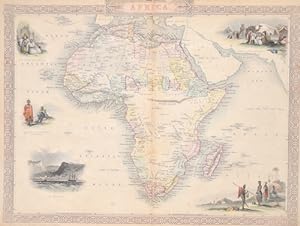
Africa.
Publicado por Artist: Tallis John ( - 1876 ) London ; issued in: London ; ca: 1851; - John Tallis was an English cartographic publisher His company John Tallis and Company published views maps and atlases in London from roughly 1838 to 1851, 1817
Librería: Antique Sommer& Sapunaru KG, München, Alemania
Miembro de asociación: ILAB VDA
Valoración del vendedor:
Technic: Steel engraving; colorit: original colored; condition: Tear on upper margin perfectly restored, size (in cm): 25 x 32,5 cm; - Map shows all of Africa with all borders, the island of Madagascar and 5 views: St. Helena, the Hottentots, Algerian residents and Arab Bedouins.
-
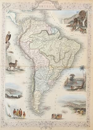
South America.
Publicado por Artist: Tallis John ( - 1876 ) London ; issued in: London / New York ; ca: 1850; - John Tallis was an English cartographic publisher His company John Tallis and Company published views maps and atlases in London from roughly 1838 to 1851, 1817
Librería: Antique Sommer& Sapunaru KG, München, Alemania
Miembro de asociación: ILAB VDA
Valoración del vendedor:
Technic: Steel engraving; colorit: original colored; condition: Some restoration at centerfold, size (in cm): 35 x 24 cm; - A beautiful Map of South America Containing Tierra-Firma, Guayana, New Granada, Amazonia, Brasil, Peru, Paraguay, Chaco, Tucuman, Chile, Patagonia and 7 fiews. Gold Washing in Brasil; Brasilian Bridge of Ropes; Rio de Janairo; Valparaiso; Natives of Chili; and Condor and Lamas of Peru.
-
Prussia
Publicado por Artist: Tallis John ( - 1876 ) London ; issued in: Edinburgh ; ca: 1840; - John Tallis was an English cartographic publisher His company John Tallis and Company published views maps and atlases in London from roughly 1838 to 1851, 1817
Librería: Antique Sommer& Sapunaru KG, München, Alemania
Miembro de asociación: ILAB VDA
Valoración del vendedor:
Technic: Steel engraving; colorit: colored; condition: Very good, size (in cm): 26 x 32,5; - Map shows total Prussia with 5 veiws of Berlin.
-
![Imagen del vendedor de Tallis's Illustrated Scripture History for the Improvement of Youth / by the Editor of Sturm's Family Devotions - [Complete in 2 Volumes] [Related Titles: Illustrated Scripture History] a la venta por MW Books](https://pictures.abebooks.com/inventory/md/md1224033946.jpg)
Tallis's Illustrated Scripture History for the Improvement of Youth / by the Editor of Sturm's Family Devotions - [Complete in 2 Volumes] [Related Titles: Illustrated Scripture History]
Publicado por London : New York ; J. & F. Tallis, [Ca. 1851], 1851
Librería: MW Books, New York, NY, Estados Unidos de America
Valoración del vendedor:
Original o primera edición
First Edition. Finely bound in contemporary aniline calf over marble boards. Gilt-cross bands with the title blocked direct in gilt. Minor generalized wear to extremities of covers, with insignificant dust-dulling. Internally, altogether clean and quite sound. A very good copy; 2 pages; Description: 2 volumes : ill. With approx. 353 engraved plates and in-text figures incl. The folding front. ; 18 cm. Added title-pages, engraved. Subjects: Bible --History of Biblical events 3 Kg.
-
Hungary - With Vignettes of Pesth and the Fortress of Buda [Budapest] and Depictions of Hungarian Nobles, the Danube and Hungarian Peasants.
Publicado por London & New York, John Tallis., 1851
Librería: Inanna Rare Books Ltd., Skibbereen, CORK, Irlanda
Valoración del vendedor:
Arte / Grabado / Póster
Original steel engraving / Vintage map. Drawn and engraved by John Rapkin. Partly hand-coloured. Illustrations by H.Warren and engravings by J.Rogers. Plate Size: 32 cm x 25.6 cm. Sheet Size: 37.4 cm x 27.4 cm. Vintage 19th century map in very good condition. Published in the Illustrated Atlas, And Modern History Of The World Geographical, Political, Commercial & Statistical, Edited By R. Montgomery Martin. Beautiful and fascinating map of Hungry- also showing the Kingdom's provinces of Croatia, Sclavonia, Banat and Transylvania. To the West lies Austria and to the south are the Ottoman Turks. Its eastern frontiers are mountains, Krapack or Carpathian Mountains to the north and, further south, the Eastern Carpathian Mountains. The Adriatic Sea is squeezed in in the lower left corner of the map. Towns and cities such as Budapest, Munkacs, Leytschan, Szekelyhid, and the Germanic-sounding Grosswarden (Oradea) and Karlsburg (Alba Iulia) are included on the map. Relief is depicted through hachuring. The major rivers, including the Danube, are also shown on the map. A scale-bar is shown near the map's upper decorative border. John Tallis (7 November 1817 3 June 1876) was an English cartographic publisher. His company, John Tallis and Company, published views, maps and atlases in London from roughly 1838 to 1851. Tallis set up as a publisher with Frederick Tallis in Cripplegate in 1842; the business moved to Smithfield in 1846, and was dissolved in 1849. From 1851 to 1854 Tallis operated as John Tallis and Company. He started The illustrated news of the world and national portrait gallery of eminent personages in 1858, selling it for Ł1,370 in 1861; it folded in 1863. (Wikipedia) The most important project John Tallis undertook, was the 'Illustrated Atlas' from 1851. The original map we offer here, was part of this exceptional Atlas and all the maps it contained are still today considered as the last reminder of an era of lavish map production. Tallis worked the project together with John Rapkin (1815-1876) and it was Rapkin's style and talent that we have to thank for when we marvel at these maps today. What makes these maps so special is the detail of engraved vignettes that surround the map and often show indigenous scenes, people in their environment and even more so, historical buildings or historical views of towns and cities, architecture and landscape. The project of 'The Illustrated Atlas' was designed to be finished just in time for the anxiously awaited "Great Exhibition of the Works of Industry of All Nations" or The Great Exhibition, sometimes referred to as the Crystal Palace Exhibition in reference to the temporary structure in which it was held, was an international exhibition that took place in Hyde Park, London, from 1 May to 11 October 1851. It was the first in a series of World's Fairs, exhibitions of culture and industry that became popular in the 19th century, and it was a much-anticipated event. The Great Exhibition was organized by Henry Cole and Prince Albert, husband of the reigning monarch, Queen Victoria. It was attended by numerous notable figures of the time, including Charles Darwin, Samuel Colt, members of the Orléanist Royal Family and the writers Charlotte Brontë, Charles Dickens, Lewis Carroll, George Eliot and Alfred Tennyson. Music for the opening was under the direction of Sir George Thomas Smart and the continuous music from the exhibited organs for the Queen's procession was "under the superintendence of William Sterndale Bennett". (Wikipedia) Sprache: english.
-
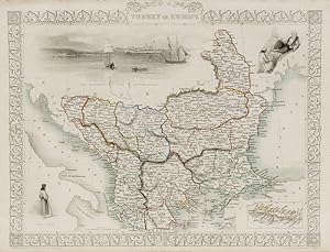
Turkey and Europe - With inset of Island of Cadia and Vignettes of Ali Pasha, Greek Caloyer and the Bosphorus and Constantinople.
Publicado por London and New York, J & F. Tallis., 1851
Librería: Inanna Rare Books Ltd., Skibbereen, CORK, Irlanda
Valoración del vendedor:
Arte / Grabado / Póster
Original steel engraving / Vintage map. Drawn and engraved by John Rapkin. Partly hand-coloured. Illustrations by H. Warren and engraved by J. Rogers. Plate Size: 32.5 cm x 26 cm. Sheet Size : 37.4 cm x 27.3 cm. Vintage 19th century map in very good condition. Published in the Illustrated Atlas, And Modern History Of The World Geographical, Political, Commercial & Statistical, Edited By R. Montgomery Martin. Beautiful and interesting map of South East Europe. Much of the Balkans was then under the control of the Ottoman Turks. The region is delineated into the historic - and future - nations and states, including Croatia, Herzegovina, Bosnia, Serbia, Albania, Macedonia, northern Greece, Bulgaria, Walachia (in Romania) and Moldova. Russia can be seen extending down into the areas around the Black Sea. Hapsburg-Austria and the heel of the Italian peninsula is shown. Corfu, Cyprus and the Greek islands can be seen lying of the archipelago. Gallipoli, Sea of Marmara, the Bosporus, and Constantinople/Istanbul and Asia Minor/Anatolia are shown in the lower right corner. John Tallis (7 November 1817 3 June 1876) was an English cartographic publisher. His company, John Tallis and Company, published views, maps and atlases in London from roughly 1838 to 1851. Tallis set up as a publisher with Frederick Tallis in Cripplegate in 1842; the business moved to Smithfield in 1846, and was dissolved in 1849. From 1851 to 1854 Tallis operated as John Tallis and Company. He started The illustrated news of the world and national portrait gallery of eminent personages in 1858, selling it for Ł1,370 in 1861; it folded in 1863. (Wikipedia) The most important project John Tallis undertook, was the 'Illustrated Atlas' from 1851. The original map we offer here, was part of this exceptional Atlas and all the maps it contained are still today considered as the last reminder of an era of lavish map production. Tallis worked the project together with John Rapkin (1815-1876) and it was Rapkin's style and talent that we have to thank for when we marvel at these maps today. What makes these maps so special is the detail of engraved vignettes that surround the map and often show indigenous scenes, people in their environment and even more so, historical buildings or historical views of towns and cities, architecture and landscape. The project of 'The Illustrated Atlas' was designed to be finished just in time for the anxiously awaited "Great Exhibition of the Works of Industry of All Nations" or The Great Exhibition, sometimes referred to as the Crystal Palace Exhibition in reference to the temporary structure in which it was held, was an international exhibition that took place in Hyde Park, London, from 1 May to 11 October 1851. It was the first in a series of World's Fairs, exhibitions of culture and industry that became popular in the 19th century, and it was a much-anticipated event. The Great Exhibition was organized by Henry Cole and Prince Albert, husband of the reigning monarch, Queen Victoria. It was attended by numerous notable figures of the time, including Charles Darwin, Samuel Colt, members of the Orléanist Royal Family and the writers Charlotte Brontë, Charles Dickens, Lewis Carroll, George Eliot and Alfred Tennyson. Music for the opening was under the direction of Sir George Thomas Smart and the continuous music from the exhibited organs for the Queen's procession was "under the superintendence of William Sterndale Bennett". (Wikipedia) Sprache: english.
-
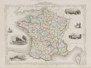
France - With Vignettes of the Palais Royal, Calais Harbour, Palace of Fontainebleau and the Bridge of Toulouse.
Publicado por London, Edinburgh & Dublin. J & F. Tallis., 1851
Librería: Inanna Rare Books Ltd., Skibbereen, CORK, Irlanda
Valoración del vendedor:
Arte / Grabado / Póster
Original steel engraving / Vintage map. Drawn and engraved by John Rapkin. Partly hand-coloured. Illustrations by J. Wray and engravings by J.B. Rogers. Plate Size: 31.5 cm x 25.5 cm. Sheet Size: 37.5 cm x 27.2 cm. Vintage 19th century map in very good condition. Published in the Illustrated Atlas, And Modern History Of The World Geographical, Political, Commercial & Statistical, Edited By R. Montgomery Martin. Beautiful map of France with ornate borders from the Victorian era. The political subdivisions delineating France into its departements are colourfully included. The more historic regions are also included on the map: Britany, Normandy, Burgundy etc. Alsace and Lorraine are still part of France when this map was published. France is bordered to the north and east by Belgium and (non-unified) Germany and, further south, by the Alps, and Switzerland and the Kingdom of Piedmont. South of the Pyrenees lies Spain. Across the English Channel is the Ancient Enemy, England. Corsica, in the Mediterranean, is also included on the map. The many famous towns and cities of France, such as Paris, Marseilles and Lyon, are also shown on the map. The French railway system is shown on the map. Relief is depicted through hachuring and the rivers, such as the Loire and the Rhone, are also included. Two pairs of smartly-dressed French citizens are also depicted. John Tallis (7 November 1817 3 June 1876) was an English cartographic publisher. His company, John Tallis and Company, published views, maps and atlases in London from roughly 1838 to 1851. Tallis set up as a publisher with Frederick Tallis in Cripplegate in 1842; the business moved to Smithfield in 1846, and was dissolved in 1849. From 1851 to 1854 Tallis operated as John Tallis and Company. He started The illustrated news of the world and national portrait gallery of eminent personages in 1858, selling it for Ł1,370 in 1861; it folded in 1863. (Wikipedia) The most important project John Tallis undertook, was the 'Illustrated Atlas' from 1851. The original map we offer here, was part of this exceptional Atlas and all the maps it contained are still today considered as the last reminder of an era of lavish map production. Tallis worked the project together with John Rapkin (1815-1876) and it was Rapkin's style and talent that we have to thank for when we marvel at these maps today. What makes these maps so special is the detail of engraved vignettes that surround the map and often show indigenous scenes, people in their environment and even more so, historical buildings or historical views of towns and cities, architecture and landscape. The project of 'The Illustrated Atlas' was designed to be finished just in time for the anxiously awaited "Great Exhibition of the Works of Industry of All Nations" or The Great Exhibition, sometimes referred to as the Crystal Palace Exhibition in reference to the temporary structure in which it was held, was an international exhibition that took place in Hyde Park, London, from 1 May to 11 October 1851. It was the first in a series of World's Fairs, exhibitions of culture and industry that became popular in the 19th century, and it was a much-anticipated event. The Great Exhibition was organized by Henry Cole and Prince Albert, husband of the reigning monarch, Queen Victoria. It was attended by numerous notable figures of the time, including Charles Darwin, Samuel Colt, members of the Orléanist Royal Family and the writers Charlotte Brontë, Charles Dickens, Lewis Carroll, George Eliot and Alfred Tennyson. Music for the opening was under the direction of Sir George Thomas Smart and the continuous music from the exhibited organs for the Queen's procession was "under the superintendence of William Sterndale Bennett". (Wikipedia) Sprache: english.
-
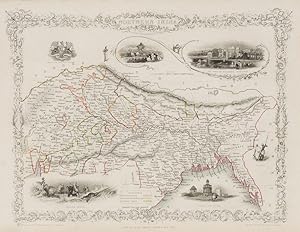
Northern India - Including the Presidency of Calcutta. With Vignettes of the Car of Juggernaut, the British Residency, Hyderabad, Hindoos, Ruins at Old Delhi and a Tiger Hunt. With the Seal of the East India Company also.
Publicado por London & New York, John Tallis & Company., 1851
Librería: Inanna Rare Books Ltd., Skibbereen, CORK, Irlanda
Valoración del vendedor:
Arte / Grabado / Póster
Original steel engraving / Vintage map. Drawn and engraved by John Rapkin. Partly hand-coloured. Illustrations by A.H. Wray and Engraved by J.H. Kernot. Plate Size: 31.5 cm x 25 cm. Sheet Size: 37.2 cm x 27.2 cm. Vintage 19th century map in very good condition. Beautifully bordered map of northern India, from Cambay to Chittagong and Aracan in the Bay of Bengal. The political subdivisions are colourfully included marking out independent Nepal and Bhutan. The regions of Jemer, Malwa, Allahabade and Assam can also be seen on the map along with the names of many towns and cities, The regions rivers, including the Ganges, are shown and relief is depicted with hachuring. John Tallis (7 November 1817 3 June 1876) was an English cartographic publisher. His company, John Tallis and Company, published views, maps and atlases in London from roughly 1838 to 1851. Tallis set up as a publisher with Frederick Tallis in Cripplegate in 1842; the business moved to Smithfield in 1846, and was dissolved in 1849. From 1851 to 1854 Tallis operated as John Tallis and Company. He started The illustrated news of the world and national portrait gallery of eminent personages in 1858, selling it for Ł1,370 in 1861; it folded in 1863. (Wikipedia) The most important project John Tallis undertook, was the 'Illustrated Atlas' from 1851. The original map we offer here, was part of this exceptional Atlas and all the maps it contained are still today considered as the last reminder of an era of lavish map production. Tallis worked the project together with John Rapkin (1815-1876) and it was Rapkin's style and talent that we have to thank for when we marvel at these maps today. What makes these maps so special is the detail of engraved vignettes that surround the map and often show indigenous scenes, people in their environment and even more so, historical buildings or historical views of towns and cities, architecture and landscape. The project of 'The Illustrated Atlas' was designed to be finished just in time for the anxiously awaited "Great Exhibition of the Works of Industry of All Nations" or The Great Exhibition, sometimes referred to as the Crystal Palace Exhibition in reference to the temporary structure in which it was held, was an international exhibition that took place in Hyde Park, London, from 1 May to 11 October 1851. It was the first in a series of World's Fairs, exhibitions of culture and industry that became popular in the 19th century, and it was a much anticipated event. The Great Exhibition was organized by Henry Cole and Prince Albert, husband of the reigning monarch, Queen Victoria. It was attended by numerous notable figures of the time, including Charles Darwin, Samuel Colt, members of the Orléanist Royal Family and the writers Charlotte Brontë, Charles Dickens, Lewis Carroll, George Eliot and Alfred Tennyson. Music for the opening was under the direction of Sir George Thomas Smart and the continuous music from the exhibited organs for the Queen's procession was "under the superintendence of William Sterndale Bennett". (Wikipedia) Sprache: english.
-
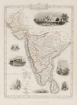
Southern India - Including the Presidencies of Bombay and Madras. With Vignettes of Shuhur, Jeypoor, The Government House, Calcutta, and Tomb of Sultan Mahomed Shah, Bejapoor. Also included are Depictions of European soldiers, natives at prayer and the Seal of the East India Company.
Publicado por London, & New York, John Tallis & Company., 1851
Librería: Inanna Rare Books Ltd., Skibbereen, CORK, Irlanda
Valoración del vendedor:
Arte / Grabado / Póster
Original steel engraving / Vintage map. Drawn and engraved by John Rapkin. Partly hand-coloured. Illustrations by A.H. Wray and Engraved by J.H. Kernot. Plate Size: 31.8 cm x 25.5 cm. Sheet Size: 37.2 cm x 27.2 cm. Vintage 19th century map in very good condition. Beautiful map of the southern Indian subcontinent, from Sinde at the mouth of the Indus Estuary in the north down through Gujerat, Bejapor and Mysore and down into the Carnatic region in the south. Hydrabad and Circars border the Bay of Bengal. Ceylon is also included in the map as are the Laccadive and Maldive islands in the Indian Ocean. Relief is depicting with hachuring. The major cities such as Bombay, Sernigapatam, and Madras are shown, as are the rivers - including the Godavery and Beema rivers. This was an India dominated by the East India Company, the British joint-stock company that came to rule large areas of India with its private armies, exercising military power and seizing administrative functions. Formed in the early 1600s to compete with the Dutch for trade and commerce in the East, the company rose to account for half of the world's trade at one point. Company rule in India lasted until 1858, when, following the Indian Rebellion of 1857, the Government of India Act 1858 led to the British Crown's assuming direct control of the Indian subcontinent in the form of the new British Raj. The company was dissolved in 1874 as a result of the East India Stock Dividend Redemption Act passed one year earlier, as the Government of India Act had by then rendered it vestigial, powerless, and obsolete. The official government machinery of British India assumed the East India Company's governmental functions and absorbed its navy and its armies in 1858. (Wikipedia) John Tallis (7 November 1817 3 June 1876) was an English cartographic publisher. His company, John Tallis and Company, published views, maps and atlases in London from roughly 1838 to 1851. Tallis set up as a publisher with Frederick Tallis in Cripplegate in 1842; the business moved to Smithfield in 1846, and was dissolved in 1849. From 1851 to 1854 Tallis operated as John Tallis and Company. He started The illustrated news of the world and national portrait gallery of eminent personages in 1858, selling it for Ł1,370 in 1861; it folded in 1863. (Wikipedia) The most important project John Tallis undertook, was the 'Illustrated Atlas' from 1851. The original map we offer here, was part of this exceptional Atlas and all the maps it contained are still today considered as the last reminder of an era of lavish map production. Tallis worked the project together with John Rapkin (1815-1876) and it was Rapkin's style and talent that we have to thank for when we marvel at these maps today. What makes these maps so special is the detail of engraved vignettes that surround the map and often show indigenous scenes, people in their environment and even more so, historical buildings or historical views of towns and cities, architecture and landscape. The project of 'The Illustrated Atlas' was designed to be finished just in time for the anxiously awaited "Great Exhibition of the Works of Industry of All Nations" or The Great Exhibition, sometimes referred to as the Crystal Palace Exhibition in reference to the temporary structure in which it was held, was an international exhibition that took place in Hyde Park, London, from 1 May to 11 October 1851. It was the first in a series of World's Fairs, exhibitions of culture and industry that became popular in the 19th century, and it was a much anticipated event. The Great Exhibition was organized by Henry Cole and Prince Albert, husband of the reigning monarch, Queen Victoria. It was attended by numerous notable figures of the time, including Charles Darwin, Samuel Colt, members of the Orléanist Royal Family and the writers Charlotte Brontë, Charles Dickens, Lewis Carroll, George Eliot and Alfred Tennyson. Music for the opening was under the direction of Sir George Thomas Smart and the continuous music from the exhibited organs for the Queen's procession was "under the superintendence of William Sterndale Bennett". (Wikipedia) Sprache: english.
-
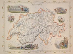
Switzerland.
Publicado por Artist: Tallis John ( - 1876 ) London ; issued in: London / New York ; ca: 1845; - John Tallis was an English cartographic publisher His company John Tallis and Company published views maps and atlases in London from roughly 1838 to 1851, 1817
Librería: Antique Sommer& Sapunaru KG, München, Alemania
Miembro de asociación: ILAB VDA
Valoración del vendedor:
Technic: Steel engraving; colorit: original colored; condition: Tears at the external upper margin restored, size (in cm): 25 x 32,5 cm; - Map shows the whole of Switzerland with 6 views (William Tell, Bern, Tyrolese, chamois hunter, etc.) and a floral border.
-
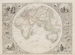
Eastern Hemisphere - With Stunning Vignettes of Indigenous Peoples, Native Animals inlaid within an Ornate Decorative Border.
Publicado por London & New York, J.& F. Tallis., 1851
Librería: Inanna Rare Books Ltd., Skibbereen, CORK, Irlanda
Valoración del vendedor:
Arte / Grabado / Póster
Original steel engraving / Vintage map. Drawn and engraved by John Rapkin. Partly hand-coloured. Illustrations by H. Warren and Engraved by J. Rogers. Plate Size: 33.3 cm x 26.3 cm. Sheet Size: 37.3 cm x 27 cm. In fair condition with a tear running across section of the map. Slight browning and paper imperfections to outer margins. Published in the Illustrated Atlas, And Modern History Of The World Geographical, Political, Commercial & Statistical, Edited By R. Montgomery Martin. Beautifully bordered and fascinating map of the eastern hemisphere, including Europe, Asia, Africa and Madagascar, Australia and the islands of the Pacific ( the Japan, Philippines, Indonesia etc.). Europe and Asia are colourfully delineated into constiteuent parts: Independent Tartary and Hindoostan in Asia stand out. Much of Africa appears rather blank - evidence that the wave of misssionaries, explorers and adventures were yet to supply anything more than rudimentary cartographic information for mapmakers. London's naval reach is also outlined on the map, linking London with its farflung imperial possessions across the globe. John Tallis (7 November 1817 3 June 1876) was an English cartographic publisher. His company, John Tallis and Company, published views, maps and atlases in London from roughly 1838 to 1851. Tallis set up as a publisher with Frederick Tallis in Cripplegate in 1842; the business moved to Smithfield in 1846, and was dissolved in 1849. From 1851 to 1854 Tallis operated as John Tallis and Company. He started The illustrated news of the world and national portrait gallery of eminent personages in 1858, selling it for Ł1,370 in 1861; it folded in 1863. (Wikipedia) The most important project John Tallis undertook, was the 'Illustrated Atlas' from 1851. The original map we offer here, was part of this exceptional Atlas and all the maps it contained are still today considered as the last reminder of an era of lavish map production. Tallis worked the project together with John Rapkin (1815-1876) and it was Rapkin's style and talent that we have to thank for when we marvel at these maps today. What makes these maps so special is the detail of engraved vignettes that surround the map and often show indigenous scenes, people in their environment and even more so, historical buildings or historical views of towns and cities, architecture and landscape. The project of 'The Illustrated Atlas' was designed to be finished just in time for the anxiously awaited "Great Exhibition of the Works of Industry of All Nations" or The Great Exhibition, sometimes referred to as the Crystal Palace Exhibition in reference to the temporary structure in which it was held, was an international exhibition that took place in Hyde Park, London, from 1 May to 11 October 1851. It was the first in a series of World's Fairs, exhibitions of culture and industry that became popular in the 19th century, and it was a much-anticipated event. The Great Exhibition was organized by Henry Cole and Prince Albert, husband of the reigning monarch, Queen Victoria. It was attended by numerous notable figures of the time, including Charles Darwin, Samuel Colt, members of the Orléanist Royal Family and the writers Charlotte Brontë, Charles Dickens, Lewis Carroll, George Eliot and Alfred Tennyson. Music for the opening was under the direction of Sir George Thomas Smart and the continuous music from the exhibited organs for the Queen's procession was "under the superintendence of William Sterndale Bennett". (Wikipedia) Sprache: english.
-
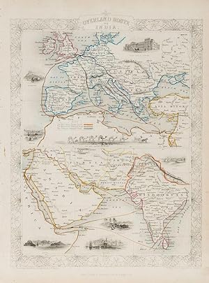
Overland Route to India - With Vignettes of London's Post Office, Gibraltar, Malta, the Mail Crossing the Desert, Suez, Aden, Bombay, and Madras.
Publicado por London & New York, John Tallis & Company., 1851
Librería: Inanna Rare Books Ltd., Skibbereen, CORK, Irlanda
Valoración del vendedor:
Arte / Grabado / Póster
Original steel engraving / Vintage map. Drawn and engraved by John Rapkin. Partly hand-coloured. Illustrations by H. Warren and Engraved by J. Rogers. Plate Size: 34.5 cm x 34 cm. Sheet Size: 27.2 cm x 37.4 cm. Vintage 19th century map in very good condition. Published in the Illustrated Atlas, And Modern History Of The World Geographical, Political, Commercial & Statistical, Edited By R. Montgomery Martin. Beautifully bordered and fascinating double map of the overland route between Britain and India. The upper map shows Europe and the links - both land and sea - running from England through to Alexandria, Egypt. The routes are; the 'Mail Steam Packet Route,' which runs around Gibraltar through Malta and onto Egypt; the 'Marseilles Overland Route' that runs across France, to Marseilles and onto Alexandria via Malta and; the 'German Overland Route' that runs through across Belgium, Germany before reaching Trieste and then onto the Mediterranean and then Egypt. The second map shows the differing routes on the next part of the journey - either across the Turkish controlled Middle East and through the Persian Gulf, or down the Red Sea and across the Indian Ocean. What the map clearly illustrates is the importance attached to India ('Hindoostan') in the Imperial mind and the need for secure communication and transport links, which necessitated control of certain choke points on the link such as Gibraltar, Malta, Suez etc. John Tallis (7 November 1817 3 June 1876) was an English cartographic publisher. His company, John Tallis and Company, published views, maps and atlases in London from roughly 1838 to 1851. Tallis set up as a publisher with Frederick Tallis in Cripplegate in 1842; the business moved to Smithfield in 1846, and was dissolved in 1849. From 1851 to 1854 Tallis operated as John Tallis and Company. He started The illustrated news of the world and national portrait gallery of eminent personages in 1858, selling it for Ł1,370 in 1861; it folded in 1863. (Wikipedia) The most important project John Tallis undertook, was the 'Illustrated Atlas' from 1851. The original map we offer here, was part of this exceptional Atlas and all the maps it contained are still today considered as the last reminder of an era of lavish map production. Tallis worked the project together with John Rapkin (1815-1876) and it was Rapkin's style and talent that we have to thank for when we marvel at these maps today. What makes these maps so special is the detail of engraved vignettes that surround the map and often show indigenous scenes, people in their environment and even more so, historical buildings or historical views of towns and cities, architecture and landscape. The project of 'The Illustrated Atlas' was designed to be finished just in time for the anxiously awaited "Great Exhibition of the Works of Industry of All Nations" or The Great Exhibition, sometimes referred to as the Crystal Palace Exhibition in reference to the temporary structure in which it was held, was an international exhibition that took place in Hyde Park, London, from 1 May to 11 October 1851. It was the first in a series of World's Fairs, exhibitions of culture and industry that became popular in the 19th century, and it was a much-anticipated event. The Great Exhibition was organized by Henry Cole and Prince Albert, husband of the reigning monarch, Queen Victoria. It was attended by numerous notable figures of the time, including Charles Darwin, Samuel Colt, members of the Orléanist Royal Family and the writers Charlotte Brontë, Charles Dickens, Lewis Carroll, George Eliot and Alfred Tennyson. Music for the opening was under the direction of Sir George Thomas Smart and the continuous music from the exhibited organs for the Queen's procession was "under the superintendence of William Sterndale Bennett". (Wikipedia) Sprache: english.
-
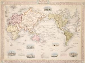
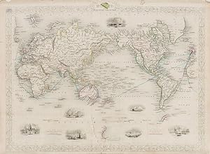
The World on Mercator's Projection - With Vignettes of London, Gibraltar, Constantinople, The Pyramids of Ghizeh, Niagara, Pont Neuf Paris and Vesuvius.
Publicado por London & New York, John Tallis & Company., 1851
Librería: Inanna Rare Books Ltd., Skibbereen, CORK, Irlanda
Valoración del vendedor:
Arte / Grabado / Póster
Original steel engraving / Vintage map. Drawn and engraved by John Rapkin. Partly hand-coloured. Illustrations by H. Warren and Engraved by J.B. Allen. Plate Size: 34.7 cm x 26.5 cm. Sheet Size: 37.3 cm x 27.2 cm. In fair condition with tears evident. Slight browning and paper imperfections to outer margins. Published in the Illustrated Atlas, And Modern History Of The World Geographical, Political, Commercial & Statistical, Edited By R. Montgomery Martin. Beautifully bordered and fascinating map of the globe utilizing the Mercator projection that became the usual projection for commercial and educational maps in the 19th Century. Even a cursory glance at the map shows the distortions associated with the map as the lands nearer the equator, such as Africa and South American, look disproportionately small when compared to the inflated sized of Greenland and northern Asia. The lack of knowledge about Antarctica is evident with only a sliver of South Victoria included on the map. Britain's colonial holdings and the steam routes between the UK and its colonies are also included on the map. The major cities and rivers are included on the map and relief depicted with hachuring. The Mercator projection is a cylindrical map projection presented by the Flemish geographer and cartographer Gerardus Mercator in 1569. It became the standard map projection for navigation because of its unique property of representing any course of constant bearing as a straight segment. John Tallis (7 November 1817 3 June 1876) was an English cartographic publisher. His company, John Tallis and Company, published views, maps and atlases in London from roughly 1838 to 1851. Tallis set up as a publisher with Frederick Tallis in Cripplegate in 1842; the business moved to Smithfield in 1846, and was dissolved in 1849. From 1851 to 1854 Tallis operated as John Tallis and Company. He started The illustrated news of the world and national portrait gallery of eminent personages in 1858, selling it for Ł1,370 in 1861; it folded in 1863. (Wikipedia) The most important project John Tallis undertook, was the 'Illustrated Atlas' from 1851. The original map we offer here, was part of this exceptional Atlas and all the maps it contained are still today considered as the last reminder of an era of lavish map production. Tallis worked the project together with John Rapkin (1815-1876) and it was Rapkin's style and talent that we have to thank for when we marvel at these maps today. What makes these maps so special is the detail of engraved vignettes that surround the map and often show indigenous scenes, people in their environment and even more so, historical buildings or historical views of towns and cities, architecture and landscape. The project of 'The Illustrated Atlas' was designed to be finished just in time for the anxiously awaited "Great Exhibition of the Works of Industry of All Nations" or The Great Exhibition, sometimes referred to as the Crystal Palace Exhibition in reference to the temporary structure in which it was held, was an international exhibition that took place in Hyde Park, London, from 1 May to 11 October 1851. It was the first in a series of World's Fairs, exhibitions of culture and industry that became popular in the 19th century, and it was a much-anticipated event. The Great Exhibition was organized by Henry Cole and Prince Albert, husband of the reigning monarch, Queen Victoria. It was attended by numerous notable figures of the time, including Charles Darwin, Samuel Colt, members of the Orléanist Royal Family and the writers Charlotte Brontë, Charles Dickens, Lewis Carroll, George Eliot and Alfred Tennyson. Music for the opening was under the direction of Sir George Thomas Smart and the continuous music from the exhibited organs for the Queen's procession was "under the superintendence of William Sterndale Bennett". (Wikipedia) Sprache: english.
-
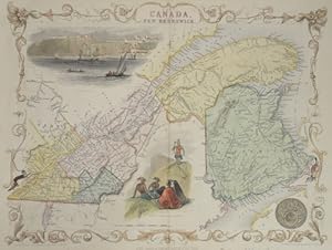
East Canada and New Brunswick
Publicado por Artist: Tallis John ( - 1876 ) London ; issued in: London ; ca: 1850; - John Tallis was an English cartographic publisher His company John Tallis and Company published views maps and atlases in London from roughly 1838 to 1851, 1817
Librería: Antique Sommer& Sapunaru KG, München, Alemania
Miembro de asociación: ILAB VDA
Valoración del vendedor:
Technic: Steel engraving; colorit: original colored; condition: Very good, size (in cm): 26 x 34; - Map shows Neubraunschweig/ Canada until the St. Laurenz river , with a decorative view of Quebec.
-
The world on Mercators projection
Publicado por Artist: Tallis John ( - 1876 ) London ; issued in: London ; ca: 1840; - John Tallis was an English cartographic publisher His company John Tallis and Company published views maps and atlases in London from roughly 1838 to 1851, 1817
Librería: Antique Sommer& Sapunaru KG, München, Alemania
Miembro de asociación: ILAB VDA
Valoración del vendedor:
Technic: Lithography; colorit: colored; condition: Lower margin enlarged, size (in cm): 26,5 x 35; - Map shows the world with 7 views of Niagara, Pyramids of Gizeh, Vesuv, Gibraltar, Constantinopel, London and Paris.
-
Falkland Islands and Patagonia - With Vignettes of Jason Islands, Penguins, Sea Eagles, Fugeans, and Christmas Sound, Tierra del Fuego.
Publicado por London & New York, John Tallis & Company., 1851
Librería: Inanna Rare Books Ltd., Skibbereen, CORK, Irlanda
Valoración del vendedor:
Arte / Grabado / Póster
Original steel engraving / Vintage map. Drawn and engraved by John Rapkin. Partly hand-coloured. Illustrations by H. Winkles and Engraved by W. Lacey. Plate Size: 25 cm x 35 cm. Sheet Size: 27 cm x 37.4 cm. Vintage 19th century map in very good condition. Two beautiful maps of the Falkland Islands (Islas Malvinas) and Patagonia bordered by a decorative boundary. In the upper section the islands of the Falkands are shown and identified: West Falkland and East Falkland the chief among them. Hachuring depicts relief and the few rivers shown are identified. A bar-scale lies beneath the islands. In the lower section is Patagonia and the archipelago of Tierra del Fuego, separated from the mainland by the Strait of Magallanes. The names and locations of the indigenous 'wandering tribes of Indians' are shown on the map also: 'Teheul-het' or Southern People, the 'Puel-che' or Eastern People, the 'Chulilon' and 'Moluche' Indians. The plethora of offshore islands, such as Chiloe Island in the Gulf of Ancud in the Pacific, and peninsular points, like the Peninsula of S. Josef on the Atlantic side, are identified. To the east the West Falkand can be seen. A bar-scale is in the lower right corner of the map. John Tallis (7 November 1817 3 June 1876) was an English cartographic publisher. His company, John Tallis and Company, published views, maps and atlases in London from roughly 1838 to 1851. Tallis set up as a publisher with Frederick Tallis in Cripplegate in 1842; the business moved to Smithfield in 1846, and was dissolved in 1849. From 1851 to 1854 Tallis operated as John Tallis and Company. He started The illustrated news of the world and national portrait gallery of eminent personages in 1858, selling it for Ł1,370 in 1861; it folded in 1863. (Wikipedia) The most important project John Tallis undertook, was the 'Illustrated Atlas' from 1851. The original map we offer here, was part of this exceptional Atlas and all the maps it contained are still today considered as the last reminder of an era of lavish map production. Tallis worked the project together with John Rapkin (1815-1876) and it was Rapkin's style and talent that we have to thank for when we marvel at these maps today. What makes these maps so special is the detail of engraved vignettes that surround the map and often show indigenous scenes, people in their environment and even more so, historical buildings or historical views of towns and cities, architecture and landscape. The project of 'The Illustrated Atlas' was designed to be finished just in time for the anxiously awaited "Great Exhibition of the Works of Industry of All Nations" or The Great Exhibition, sometimes referred to as the Crystal Palace Exhibition in reference to the temporary structure in which it was held, was an international exhibition that took place in Hyde Park, London, from 1 May to 11 October 1851. It was the first in a series of World's Fairs, exhibitions of culture and industry that became popular in the 19th century, and it was a much anticipated event. The Great Exhibition was organized by Henry Cole and Prince Albert, husband of the reigning monarch, Queen Victoria. It was attended by numerous notable figures of the time, including Charles Darwin, Samuel Colt, members of the Orléanist Royal Family and the writers Charlotte Brontë, Charles Dickens, Lewis Carroll, George Eliot and Alfred Tennyson. Music for the opening was under the direction of Sir George Thomas Smart and the continuous music from the exhibited organs for the Queen's procession was "under the superintendence of William Sterndale Bennett". (Wikipedia) Sprache: english.
-
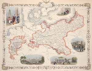
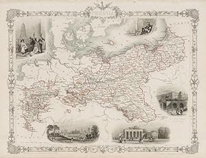
Prussia - with Vignettes of Berlin, Brandenburg Gate, The Royal Palace and French Church Berlin and Frederick the Great.
Publicado por London, Edinburgh & Dublin, J & F. Tallis., 1851
Librería: Inanna Rare Books Ltd., Skibbereen, CORK, Irlanda
Valoración del vendedor:
Arte / Grabado / Póster
Original steel engraving / Vintage map. Drawn and engraved by John Rapkin. Partly hand-coloured. Illustrations by J. Salmon and engravings by S. Fisher. Plate Size: 33 cm x 26.5 cm. Sheet Size: 37.4 cm x 27.4 cm. Vintage 19th century map in very good condition. Published in the Illustrated Atlas, And Modern History Of The World Geographical, Political, Commercial & Statistical, Edited By R. Montgomery Martin. Beautiful and fascinating map of Prussia from the Victorian Era. Prussia's boundaries are highlighted and illustrate its non-contiguous make up. Four De-jure 'Kleinstaaterei', or mini-/micro-states can be seen holding within the borders of Prussia - evidence of the fragmented nature of the German lands throughout the existence of the recently expired Holy Roman Empire. But this was changing: In the west lie Prussia's post-1815 acquisitions in Westphalia and the Rhineland, while in the east 'Prussian Poland' and 'Posen' remind the viewers of the fate of the erstwhile Polish state. Four additional territorial possessions resemble globules from the main bodies of Prussian land. The more ancient lands of East Prussia and Brandenburg are identified also. Prussia is located in a busy neighbourhood with Denmark, Sweden, Russia, Austria, Saxony, France, Belgium and Holland abutting Berlin's territory. The islands of the Baltic are also identified. The much-heralded German railway system is shown on the map, linking ports like Hamburg and Stettin to Berlin. The map is littered with the names of famous towns and cities such as Memel, Konigsberg and Warsaw in the East, Cracow, Prague and Dresden in the South to Magdeburg and Dortmund in the west. The region's rivers, such as the Elbe and Vistula are also identified. Relief is depicted through hachuring. A scale-bar is shown in the lower left corner. A Prussian eagle stands perched upon the highly decorative map border. John Tallis (7 November 1817 3 June 1876) was an English cartographic publisher. His company, John Tallis and Company, published views, maps and atlases in London from roughly 1838 to 1851. Tallis set up as a publisher with Frederick Tallis in Cripplegate in 1842; the business moved to Smithfield in 1846, and was dissolved in 1849. From 1851 to 1854 Tallis operated as John Tallis and Company. He started The illustrated news of the world and national portrait gallery of eminent personages in 1858, selling it for Ł1,370 in 1861; it folded in 1863. (Wikipedia) The most important project John Tallis undertook, was the 'Illustrated Atlas' from 1851. The original map we offer here, was part of this exceptional Atlas and all the maps it contained are still today considered as the last reminder of an era of lavish map production. Tallis worked the project together with John Rapkin (1815-1876) and it was Rapkin's style and talent that we have to thank for when we marvel at these maps today. What makes these maps so special is the detail of engraved vignettes that surround the map and often show indigenous scenes, people in their environment and even more so, historical buildings or historical views of towns and cities, architecture and landscape. The project of 'The Illustrated Atlas' was designed to be finished just in time for the anxiously awaited "Great Exhibition of the Works of Industry of All Nations" or The Great Exhibition, sometimes referred to as the Crystal Palace Exhibition in reference to the temporary structure in which it was held, was an international exhibition that took place in Hyde Park, London, from 1 May to 11 October 1851. It was the first in a series of World's Fairs, exhibitions of culture and industry that became popular in the 19th century, and it was a much-anticipated event. The Great Exhibition was organized by Henry Cole and Prince Albert, husband of the reigning monarch, Queen Victoria. It was attended by numerous notable figures of the time, including Charles Darwin, Samuel Colt, members of the Orléanist Royal Family and the writers Charlotte Brontë, Charles Dickens, Lewis Carroll, George Eliot and Alfred Tennyson. Music for the opening was under the direction of Sir George Thomas Smart and the continuous music from the exhibited organs for the Queen's procession was "under the superintendence of William Sterndale Bennett". (Wikipedia) Sprache: english.
-
Islands in the Atlantic - Azores or Western Isles - Madeira [Inset] - Canary Islands - Cape de Verde Islands - Bermudas or Summer Islands. With Vignettes and illustrations of Faval, Azores, Chapel in the Rock, St Vincente, Tenerife, Canary Islands and Funchal, Madeira.
Publicado por London & New York, John Tallis., 1851
Librería: Inanna Rare Books Ltd., Skibbereen, CORK, Irlanda
Valoración del vendedor:
Arte / Grabado / Póster
Original steel engraving / Vintage map. Drawn and engraved by John Rapkin. Partly hand-coloured. Illustrations drawn and engraved by H. Winkles. Plate Size: 24.5 cm x 36.5 cm. Sheet Size: 27.2 cm x 37.4 cm. Vintage 19th century map in very good condition. Beautiful map with gorgeous illustrated vignettes from the Victorian publisher. The coast of west Africa can be seen in the lower corner. Relief on Madeira shown with hachuring. Rivers and towns of Madeira also listed. The potentially dangerous waters off Bermuda are highlighted pictorially. The individual names of the Azores, Canary and Cape Verde islands can also be seen. A bar scale lies just under Bermuda. John Tallis (7 November 1817 3 June 1876) was an English cartographic publisher. His company, John Tallis and Company, published views, maps and atlases in London from roughly 1838 to 1851. Tallis set up as a publisher with Frederick Tallis in Cripplegate in 1842; the business moved to Smithfield in 1846, and was dissolved in 1849. From 1851 to 1854 Tallis operated as John Tallis and Company. He started The illustrated news of the world and national portrait gallery of eminent personages in 1858, selling it for Ł1,370 in 1861; it folded in 1863. (Wikipedia) The most important project John Tallis undertook, was the 'Illustrated Atlas' from 1851. The original map we offer here, was part of this exceptional Atlas and all the maps it contained are still today considered as the last reminder of an era of lavish map production. Tallis worked the project together with John Rapkin (1815-1876) and it was Rapkin's style and talent that we have to thank for when we marvel at these maps today. What makes these maps so special is the detail of engraved vignettes that surround the map and often show indigenous scenes, people in their environment and even more so, historical buildings or historical views of towns and cities, architecture and landscape. The project of 'The Illustrated Atlas' was designed to be finished just in time for the anxiously awaited "Great Exhibition of the Works of Industry of All Nations" or The Great Exhibition, sometimes referred to as the Crystal Palace Exhibition in reference to the temporary structure in which it was held, was an international exhibition that took place in Hyde Park, London, from 1 May to 11 October 1851. It was the first in a series of World's Fairs, exhibitions of culture and industry that became popular in the 19th century, and it was a much anticipated event. The Great Exhibition was organized by Henry Cole and Prince Albert, husband of the reigning monarch, Queen Victoria. It was attended by numerous notable figures of the time, including Charles Darwin, Samuel Colt, members of the Orléanist Royal Family and the writers Charlotte Brontë, Charles Dickens, Lewis Carroll, George Eliot and Alfred Tennyson. Music for the opening was under the direction of Sir George Thomas Smart and the continuous music from the exhibited organs for the Queen's procession was "under the superintendence of William Sterndale Bennett". (Wikipedia) Sprache: english.
![Imagen del vendedor de Hungary - With Vignettes of Pesth and the Fortress of Buda [Budapest] and Depictions of Hungarian Nobles, the Danube and Hungarian Peasants. a la venta por Inanna Rare Books Ltd.](https://pictures.abebooks.com/inventory/md/md30569906506.jpg)

![Imagen del vendedor de Islands in the Atlantic - Azores or Western Isles - Madeira [Inset] - Canary Islands - Cape de Verde Islands - Bermudas or Summer Islands. With Vignettes and illustrations of Faval, Azores, Chapel in the Rock, St Vincente, Tenerife, Canary Islands and Funchal, Madeira. a la venta por Inanna Rare Books Ltd.](https://pictures.abebooks.com/inventory/md/md30569910910.jpg)