Importe total (1 artículo artículos):
Destino del pedido:

humboldt alexander 1769 1859 bonpland aimé (2 resultados)
Ir a los resultados principales
Tipo de artículo
- Todos los tipos de productos
- Libros (2)
- Revistas y publicaciones
- Cómics
- Partituras
- Arte, grabados y pósters
- Fotografías
- Mapas
- Manuscritos y coleccionismo de papel
Condición
Encuadernación
Más atributos
- Primera edición (1)
- Firmado
- Sobrecubierta
- Con imágenes (1)
- No impresión bajo demanda (2)
Gastos de envío gratis
- Gastos de Envío Gratis a EEUU
Ubicación del vendedor
Valoración de los vendedores
-
Personal Narrative of Travels to the Equinoctial Regions of the New Continent During the Years 1799-1804 by Alexander De Humboldt and Aimé Bonpland: With Maps, Plans &c.; v.5: pt.2 (1821)
Publicado por Legare Street Press, 2021
ISBN 10: 1014210704ISBN 13: 9781014210708
Librería: Lucky's Textbooks, Dallas, TX, Estados Unidos de America
Valoración del vendedor:

Libro
Condición: New.
-
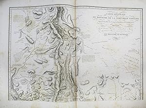
Essai politique sur le royaume de la Nouvelle-Espagne
Publicado por F. Schoell, Paris, 1811
Librería: Arader Galleries - AraderNYC, New York, NY, Estados Unidos de America
Valoración del vendedor:
Original o primera edición
3 volumes: 2 volumes text, 4to., (13 4/8 x 10 inches); and atlas volume, folio (22 x 16 inches). Half-titles in each volume. With the dedication leaf and 4-page dedication to Charles IV. 21 engraved maps, profiles, views, and charts on 19 sheets, four hand- colored (some intermittent pale spotting.) Modern tan calf-backed black marbled paper boards, spines gilt, by Atelier Laurenchet. Provenance: Bookplates of Jay T. Snider, Collection of Historical Americana. First edition, a very rare variant. Yale has a copy of the true first edition with an 1808 title-page and the dedication leaf to Charles IV. The present copy is dated 1811 in the text volumes, but is actually made up of the text as printed in 1808, including the suppressed dedication leaf to Charles IV of Spain. This copy, with the same format and pagination but with the suppressed dedication, shows that the 1811 edition was actually made from the sheets of the 1808 printing, with the dedication removed and the 1811 titles inserted. This edition has generally been overlooked by bibliographers (although Thomas Streeter correctly described the accompanying atlas and surmised this text might exist), the 1809-1814 Tübingen edition generally described as the first. Evidently published in the spring of 1808, the present edition is markedly different in text from that which began to appear the next year. It was suppressed, probably by Humboldt himself. He dedicated the work to Charles IV of Spain, who had allowed him to travel freely through the Spanish colonies. Almost concurrently with the book's publication, Napoleon invaded Spain and deposed Charles, installing his own brother, Joseph Bonaparte, on the Spanish throne. Already under suspicion as a Prussian spy and only allowed to remain in Paris through the intercession of his scientific friends, Humboldt's dedication to the abdicated monarch might have sealed his fate. He may also have had second thoughts about the scope of the work, as the Tübingen edition is greatly enlarged. In 1799 Alexander von Humboldt went to Spain and received from the king permission to visit and make scientific investigations in all the Spanish possessions in Europe, America, with privileges never before granted to any traveller. From 1799 to 1804, Humboldt was accompanied by the French botanist Aimé Bonpland, and together they made observations on geology, geography, zoology, botany and the political and social character of the regions. His exploration of Orinoco River was the first to furnish any positive knowledge of that river. In 1802, in exploring the volcanoes of Ecuador, he ascended heights that had not previously been attained, and on Chimborazo reached the altitude of 19,286 feet. Afterward he made a profile of Mexico from sea to sea--this was the first profile ever given of an entire country. After his return to Paris, and over a period of about two decades, Humboldt undertook to publish the results of his study in the monumental 29-volume "Voyage aux regions equinoxiales du Nouveau Continent". The present work is the third part of this series, consisting of two text volumes and an atlas of maps relating to New Spain, including much of present-day southwestern United States. This comprised the first scientific description of the American Southwest and includes a wealth of new information on California and Texas. The atlas includes plates on volcanoes, land profiles, a map of the southern part of North America, maps of Mexico and many of its parts, and most importantly, Humboldt's two-sheet "Carte Generale du Royaume de la Nouvelle Espagne." This map contained the most up-to-date geographic depiction of Texas, California and the rest of Mexico, and it became the prototype rendering for much of the region for the next several decades. Carl Wheat called the map a "truly magnificent cartographic achievement." Cowan p. 296 (another edition); Graff 2009; Hill p. 149 (another edition); Phillips 2682; Reese & Miles Creating America 23; R For.