
Importe total (1 artículo artículos):
Destino del pedido:

hughes virtue (35 resultados)
Ir a los resultados principales
Tipo de artículo
- Todo tipo de artículos
- Libros
- Revistas y publicaciones
- Cómics
- Partituras
- Arte, grabados y pósters
- Fotografías
- Mapas (35)
-
Manuscritos y
coleccionismo de papel
Condición
- Todo
- Nuevos
- Antiguos o usados
Encuadernación
- Todo
- Tapa dura
- Tapa blanda
Más atributos
- Primera edición
- Firmado
- Sobrecubierta
- Con imágenes del vendedor
- Sin impresión bajo demanda
Ubicación del vendedor
Valoración de los vendedores
-
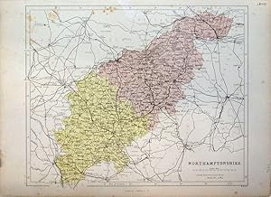
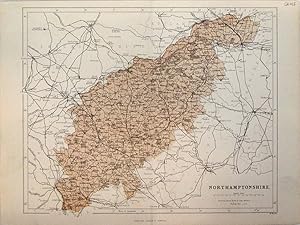
Northamptonshire
Ańo de publicación: 1873
Librería: theoldmapman, Weston super Mare, Reino Unido
Valoración del vendedor:

Mapa
Single sheet. Colour printed map of the county showing roads and railways. The Divisions in different colours. Unfolded. A little spotting. 31 x 24 cm.
-
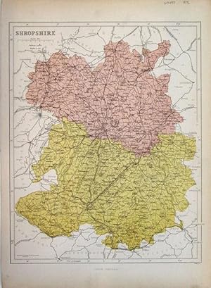
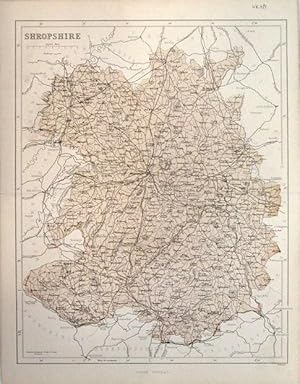
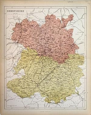
Shropshire
Ańo de publicación: 1873
Librería: theoldmapman, Weston super Mare, Reino Unido
Valoración del vendedor:
Mapa
Single sheet. Colour printed map of the county showing roads and railways. The Divisions in different colours. Unfolded. Small ink smear in Montgomery. 24 x 31 cm.
-
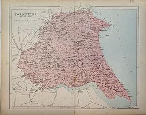
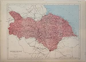
Yorkshire, East Riding
Ańo de publicación: 1868
Librería: theoldmapman, Weston super Mare, Reino Unido
Valoración del vendedor:
Mapa
Single sheet. Colour printed map of the county showing roads and railways. Toning on centrefold which is strengthened at top. 30 x 24 cm.
-
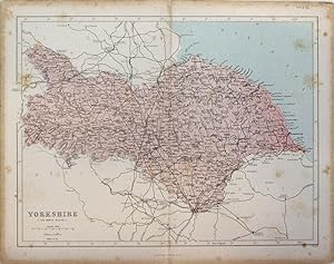
Yorkshire, North Riding
Ańo de publicación: 1868
Librería: theoldmapman, Weston super Mare, Reino Unido
Valoración del vendedor:
Mapa
Single sheet. Colour printed map of the county showing roads and railways. Some foxing. Centrefold strengthened. 31 x 24 cm.
-
Shropshire
Ańo de publicación: 1868
Librería: theoldmapman, Weston super Mare, Reino Unido
Valoración del vendedor:
Mapa
Single sheet. Colour printed map of the county showing roads and railways. 24 x 31 cm.
-
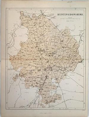
Huntingdonshire
Ańo de publicación: 1868
Librería: theoldmapman, Weston super Mare, Reino Unido
Valoración del vendedor:
Mapa
Single sheet. Colour printed map of the county showing roads and railways. Centrefold strengthened. 24 x 31 cm.
-
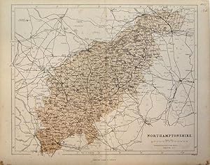
Northamptonshire
Ańo de publicación: 1868
Librería: theoldmapman, Weston super Mare, Reino Unido
Valoración del vendedor:
Mapa
Single sheet. Colour printed map of the county showing roads and railways. Centrefold strengthened. A little spotting. 31 x 24 cm.
-
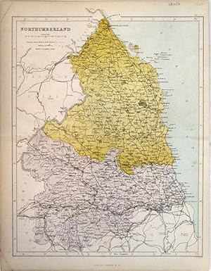
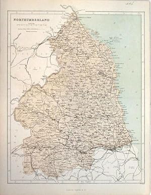
Northumberland
Ańo de publicación: 1868
Librería: theoldmapman, Weston super Mare, Reino Unido
Valoración del vendedor:
Mapa
Single sheet. Colour printed map of the county showing roads and railways. The Divisions in different colours. A trifle grubby. 24 x 32 cm.
-
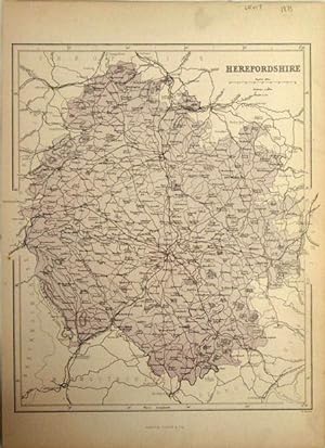
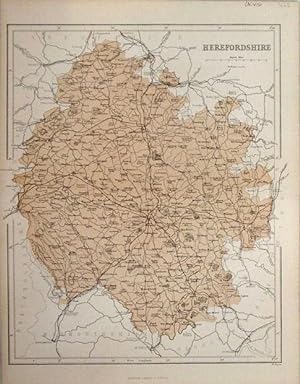
Herefordshire
Ańo de publicación: 1873
Librería: theoldmapman, Weston super Mare, Reino Unido
Valoración del vendedor:
Mapa
Single sheet. Colour printed map of the county showing roads and railways. Very minor edge tear repaired. Unfolded. 25 x 30 cm.
-
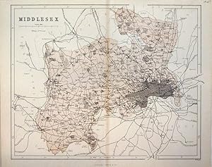
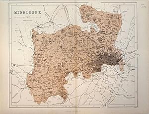
Middlesex
Publicado por c 1870, 1870
Librería: theoldmapman, Weston super Mare, Reino Unido
Valoración del vendedor:
Mapa
Single sheet. Colour printed map of the county showing roads and railways. Centrefold repaired at bottom. Top edge strengthened. 30 x 24 cm.
-
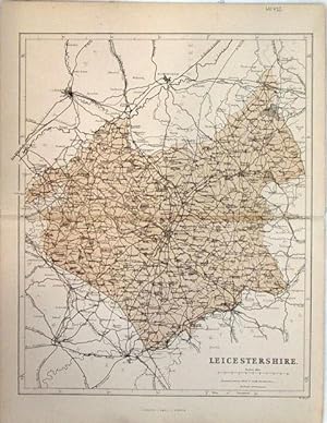
Leicestershire
Ańo de publicación: 1868
Librería: theoldmapman, Weston super Mare, Reino Unido
Valoración del vendedor:
Mapa
Single sheet. Colour printed map of the county showing roads and railways. Centrefold repaired at RHS. Marginal pencil notes erased. 25 x 30 cm.
-
Leicestershire
Ańo de publicación: 1868
Librería: theoldmapman, Weston super Mare, Reino Unido
Valoración del vendedor:
Mapa
Single sheet. Colour printed map of the county showing roads and railways. Centrefold repaired. Marginal tear repaired. 25 x 30 cm.
-
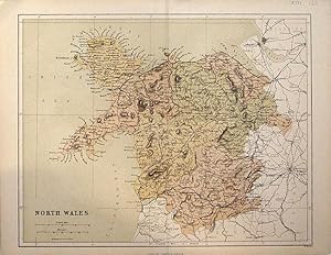
North Wales
Ańo de publicación: 1868
Librería: theoldmapman, Weston super Mare, Reino Unido
Valoración del vendedor:
Mapa
Single sheet. Colour printed map of the Counties, showing roads and railways. 30 x 24 cm.
-
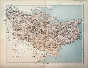
Kent
Ańo de publicación: 1868
Librería: theoldmapman, Weston super Mare, Reino Unido
Valoración del vendedor:
Mapa
Single sheet. Colour printed map of the county showing roads and railways. Evidence of tracing outline only visible from the back. 31 x 23 cm.
-
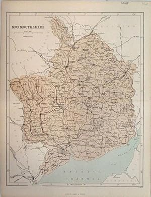
Monmouthshire
Ańo de publicación: 1868
Librería: theoldmapman, Weston super Mare, Reino Unido
Valoración del vendedor:
Mapa
Single sheet. Colour printed map of the county showing roads and railways. 24 x 31 cm.
-
Middlesex
Ańo de publicación: 1860
Librería: theoldmapman, Weston super Mare, Reino Unido
Valoración del vendedor:
Mapa
Single sheet. Colour printed map of the county showing roads and railways. 30 x 24 cm.
-
Northamptonshire
Ańo de publicación: 1868
Librería: theoldmapman, Weston super Mare, Reino Unido
Valoración del vendedor:
Mapa
Single sheet. Colour printed map of the county showing roads and railways. Short marginal repairs. 31 x 24 cm.
-
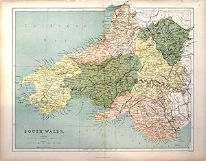
South Wales
Ańo de publicación: 1868
Librería: theoldmapman, Weston super Mare, Reino Unido
Valoración del vendedor:
Mapa
Single sheet. Colour printed map of the Counties as far East as Abergavenny, showing roads and railways. Top edge strengthened. 30 x 24 cm.
-
Shropshire
Ańo de publicación: 1868
Librería: theoldmapman, Weston super Mare, Reino Unido
Valoración del vendedor:
Mapa
Single sheet. Colour printed map of the county showing roads and railways. The Divisions in different colours. Short marginal repairs. 24 x 31 cm.
-
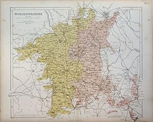
Worcestershire
Ańo de publicación: 1868
Librería: theoldmapman, Weston super Mare, Reino Unido
Valoración del vendedor:
Mapa
Single sheet. Colour printed map of the county showing roads and railways. The Divisions in different colours. 30 x 27 cm.
-
Northumberland
Ańo de publicación: 1868
Librería: theoldmapman, Weston super Mare, Reino Unido
Valoración del vendedor:
Mapa
Single sheet. Colour printed map of the county showing roads and railways. 24 x 32 cm.
-
Herefordshire
Ańo de publicación: 1868
Librería: theoldmapman, Weston super Mare, Reino Unido
Valoración del vendedor:
Mapa
Single sheet. Colour printed map of the county showing roads and railways. Centrefold strengthened. 25 x 30 cm.
-

Staffordshire
Ańo de publicación: 1868
Librería: theoldmapman, Weston super Mare, Reino Unido
Valoración del vendedor:
Mapa
Single sheet. Colour printed map of the county showing roads and railways. 24 x 31 cm.
-
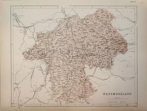
Westmoreland
Ańo de publicación: 1873
Librería: theoldmapman, Weston super Mare, Reino Unido
Valoración del vendedor:
Mapa
Single sheet. Colour printed map of the county showing roads and railways. Unfolded. 30 x 24 cm.
-
Yorkshire, North Riding
Ańo de publicación: 1873
Librería: theoldmapman, Weston super Mare, Reino Unido
Valoración del vendedor:
Mapa
Single sheet. Colour printed map of the county showing roads and railways. Minor edge repairs. Unfolded. 31 x 24 cm.
-
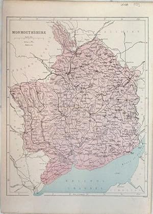
Monmouthshire
Ańo de publicación: 1873
Librería: theoldmapman, Weston super Mare, Reino Unido
Valoración del vendedor:
Mapa
Single sheet. Colour printed map of the county showing roads and railways. Unfolded. 24 x 31 cm.
-
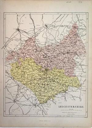
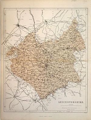
Leicestershire
Ańo de publicación: 1873
Librería: theoldmapman, Weston super Mare, Reino Unido
Valoración del vendedor:
Mapa
Single sheet. Colour printed map of the county showing roads and railways. The Divisions in different colours. Unfolded. 25 x 30 cm.
-
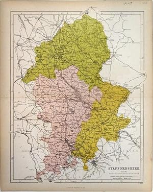
Staffordshire
Ańo de publicación: 1868
Librería: theoldmapman, Weston super Mare, Reino Unido
Valoración del vendedor:
Mapa
Single sheet. Colour printed map of the county showing roads and railways. The Divisions in different colours. 24 x 31 cm.
-
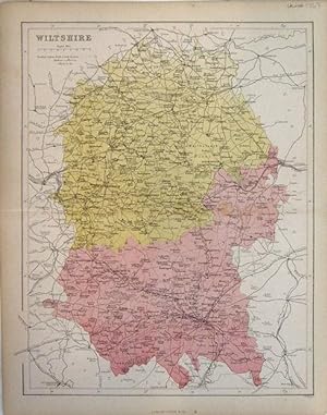
Wiltshire
Ańo de publicación: 1868
Librería: theoldmapman, Weston super Mare, Reino Unido
Valoración del vendedor:
Mapa
Single sheet. Colour printed map of the county showing roads and railways. The Divisions in different colours. 24 x 31 cm.
-
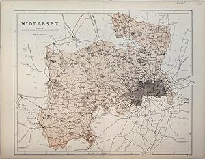
Middlesex
Ańo de publicación: 1868
Librería: theoldmapman, Weston super Mare, Reino Unido
Valoración del vendedor:
Mapa
Single sheet. Colour printed map of the county showing roads and railways. 30 x 24 cm.