
Importe total (1 artículo artículos):
Destino del pedido:

h f walling o w gray (31 resultados)
Ir a los resultados principales
Tipo de artículo
- Todo tipo de artículos
- Libros (31)
- Revistas y publicaciones
- Cómics
- Partituras
- Arte, grabados y pósters
- Fotografías
- Mapas
-
Manuscritos y
coleccionismo de papel
Condición
- Todo
- Nuevos
- Antiguos o usados
Encuadernación
Más atributos
- Primera edición
- Firmado
- Sobrecubierta
- Con imágenes del vendedor (29)
- Sin impresión bajo demanda
Ubicación del vendedor
Valoración de los vendedores
-

1872 Historical Topographical Atlas of the State of Pennsylvania
Publicado por The Bookmark, 1977
Librería: Berryville Old Book Shop, Berryville, VA, Estados Unidos de America
Valoración del vendedor:

Oversized paperback. Reprint. 146 pgs. 1977 reproduction to scale of 1872 atlas. Very good softcover. Top edge of spine nicked. No international shipping due to size.
-
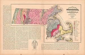
Geological Map of Massachusetts
Ańo de publicación: 1871
Librería: Art Source International Inc., Boulder, CO, Estados Unidos de America
Valoración del vendedor:
This hand colored map is from Walling and Grays Official Topographical Atlas of Massachusetts from Astronomical, Trigonometrical, and Various Local Surveys published in 1871. This map shows the geological features of Massachusetts- the mineral and the lithological group it is from are identified by color from a key on the map. Surrounding the map is text explaining the research on the states geological features and the information illustrated in the map. This map measures 14.75 inches by 24 inches.
-
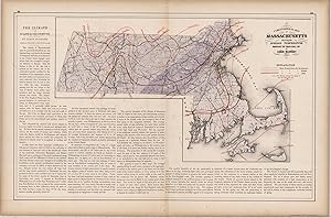
Climatological Map of Massachusetts Showing the Average Temperature and Amount of Rainfall
Ańo de publicación: 1871
Librería: Art Source International Inc., Boulder, CO, Estados Unidos de America
Valoración del vendedor:
This hand colored map is from Walling and Grays Official Topographical Atlas of Massachusetts from Astronomical, Trigonometrical, and Various Local Surveys published in 1871. This climatological map illustrates the average temperature and rain fall in Massachusetts for the Summer, Winter and year in full. Details include counties, important cities and rail lines. The surrounding text describes the climate and expands on the information provided in the map. This map measures 14.5 inches by 23.5 inches.
-

Map of Worcester County, Massachusetts
Ańo de publicación: 1871
Librería: Art Source International Inc., Boulder, CO, Estados Unidos de America
Valoración del vendedor:
This hand colored map is from Walling and Grays Official Topographical Atlas of Massachusetts from Astronomical, Trigonometrical, and Various Local Surveys," published in 1871. This map of Worcester County is colored in vibrant pastels. Details include rail lines, county names, the names of important cities, major roads, lakes and rivers. This map measures 23 inches by 17 inches.
-
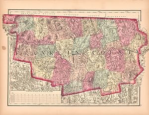
Map of Franklin County, Massachusetts
Ańo de publicación: 1871
Librería: Art Source International Inc., Boulder, CO, Estados Unidos de America
Valoración del vendedor:
This hand colored map is from Walling and Grays Official Topographical Atlas of Massachusetts from Astronomical, Trigonometrical, and Various Local Surveys published in 1871. This bright pastel map is of Franklin County. Details include rail lines, the names of important cities, major roads, lakes and rivers.Important land owners and businesses are also identified. This map measures 10.5 inches by 17 inches.
-
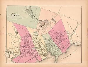
City of Lynn, Massachusetts
Ańo de publicación: 1871
Librería: Art Source International Inc., Boulder, CO, Estados Unidos de America
Valoración del vendedor:
This hand colored map is from Walling and Grays Official Topographical Atlas of Massachusetts from Astronomical, Trigonometrical, and Various Local Surveys published in 1871. This bright pastel map of the City of Lynn and its surrounding areas illustrates the street plan of the area. Details include rail lines, the names of neighborhoods, rail lines, lakes and rivers as well as important buildings. This map measures 11 inches by 14.5 inches.
-
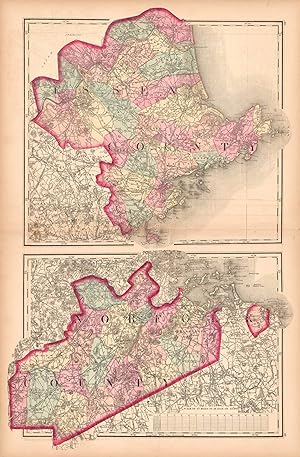
Map of Essex County and Norfolk County
Ańo de publicación: 1871
Librería: Art Source International Inc., Boulder, CO, Estados Unidos de America
Valoración del vendedor:
This hand colored map is from Walling and Grays Official Topographical Atlas of Massachusetts from Astronomical, Trigonometrical, and Various Local Surveys published in 1871. This bright pastel detailed map of Essex and Norfolk counties includes rail lines,lakes and rivers, as well as important buildings. This map measures 25 inches by 16.5 inches.
-
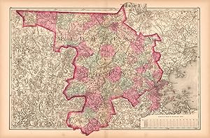
Map of Middlesex County
Ańo de publicación: 1871
Librería: Art Source International Inc., Boulder, CO, Estados Unidos de America
Valoración del vendedor:
This hand colored map is from Walling and Grays Official Topographical Atlas of Massachusetts from Astronomical, Trigonometrical, and Various Local Surveys published in 1871. This bright pastel detailed map of Middlesex County includes rail lines,lakes and rivers- as well as important buildings. This map measures 17 inches by 23.25 inches.
-
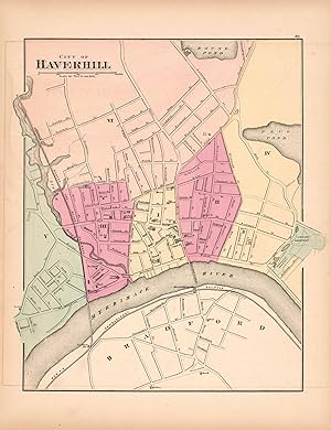
City of Haverhill
Ańo de publicación: 1871
Librería: Art Source International Inc., Boulder, CO, Estados Unidos de America
Valoración del vendedor:
This hand colored map is from Walling and Grays Official Topographical Atlas of Massachusetts from Astronomical, Trigonometrical, and Various Local Surveys published in 1871. This bright pastel map of Haverhill and its surrounding areas illustrates the street plan of the area. Details include rail lines, the names of neighborhoods, rail lines,lakes and rivers as well as important buildings. This map measures 14 inches by 11 inches.
-
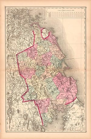
Map of Plymouth County
Ańo de publicación: 1871
Librería: Art Source International Inc., Boulder, CO, Estados Unidos de America
Valoración del vendedor:
This hand colored map is from Walling and Grays Official Topographical Atlas of Massachusetts from Astronomical, Trigonometrical, and Various Local Surveys published in 1871. This bright pastel detailed map of Essex and Norfolk counties includes rail lines,lakes and rivers, as well as important buildings.Swamp land and hills are indicated. This map measures 23 inches by 14.5 inches.
-
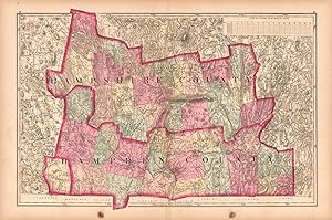
Map of Hampshire County and Hampden County, Massacusetts
Ańo de publicación: 1871
Librería: Art Source International Inc., Boulder, CO, Estados Unidos de America
Valoración del vendedor:
This hand colored map is from Walling and Grays Official Topographical Atlas of Massachusetts from Astronomical, Trigonometrical, and Various Local Surveys published in 1871. This map is of Hampshire and Hampden Counties colored in vibrant pastels. Details include rail lines, county names, the names of important cities, major roads, lakes and rivers. This map measures 16 inches by 22.75 inches.
-
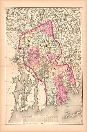
Map of Bristol County
Ańo de publicación: 1871
Librería: Art Source International Inc., Boulder, CO, Estados Unidos de America
Valoración del vendedor:
This hand colored map is from Walling and Grays Official Topographical Atlas of Massachusetts from Astronomical, Trigonometrical, and Various Local Surveys, published in 1871. This map is of Bristol County colored in vibrant pastels. Details include rail lines, county names, the names of important cities, major roads, lakes and rivers. This map measures 23 inches by 15 inches.
-
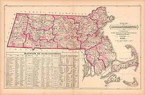
Railway and Township Map of Massachusetts
Ańo de publicación: 1871
Librería: Art Source International Inc., Boulder, CO, Estados Unidos de America
Valoración del vendedor:
This hand colored map is from Walling and Grays Official Topographical Atlas of Massachusetts from Astronomical, Trigonometrical, and Various Local Surveys published in 1871. This map is of rail lines throughout Massachusetts and shows details including county and important city names, current and planned rail lines. A chart is included listing the branches (origination and destination) and their lenghths. This map measures 14.75 inches by 24 inches.
-
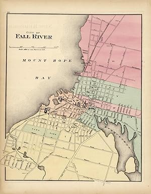
City of Fall River, Massachusetts
Ańo de publicación: 1871
Librería: Art Source International Inc., Boulder, CO, Estados Unidos de America
Valoración del vendedor:
This hand colored map is from Walling and Grays Official Topographical Atlas of Massachusetts from Astronomical, Trigonometrical, and Various Local Surveys published in 1871. This bright pastel map of Fall River and its surrounding areas illustrates the street plan of the area. Details include rail lines, the names of neighborhoods, rail lines, lakes and rivers as well as important buildings. This map measures 14 inches by 11.5 inches.
-
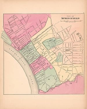
City of Springfield
Ańo de publicación: 1871
Librería: Art Source International Inc., Boulder, CO, Estados Unidos de America
Valoración del vendedor:
This hand colored map is from Walling and Grays Official Topographical Atlas of Massachusetts from Astronomical, Trigonometrical, and Various Local Surveys published in 1871. This bright pastel map of the City of Springfield and its surrounding areas illustrates the street plan of the area. Details include rail lines, the names of neighborhoods,rail lines,lakes and rivers as well as important buildings. This map measures 12 inches by 11.75 inches.
-
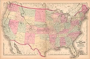
Map of the United States and Territories
Ańo de publicación: 1871
Librería: Art Source International Inc., Boulder, CO, Estados Unidos de America
Valoración del vendedor:
This hand colored map is from Walling and Grays Official Topographical Atlas of Massachusetts from Astronomical, Trigonometrical, and Various Local Surveys published in 1871. This bright pastel United States map illustrated the process of developement of the country by the obvious concentration of cities and rail lines to the eastern side. Details include rail lines, the names of important cities,rail lines,lakes and rivers. This map measures 17 inches by 25.5 inches.
-
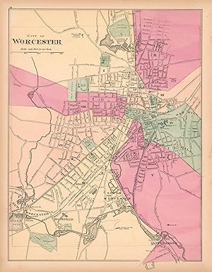
City of Worcester
Ańo de publicación: 1871
Librería: Art Source International Inc., Boulder, CO, Estados Unidos de America
Valoración del vendedor:
This hand colored map is from Walling and Grays Official Topographical Atlas of Massachusetts from Astronomical, Trigonometrical, and Various Local Surveys published in 1871. This bright pastel map of the City of Worcester and its surrounding areas illustrates the street plan of the area. Details include rail lines, the names of neighborhoods,rail lines,lakes and rivers as well as important buildings. This map measures 15.5 inches by 12 inches.
-
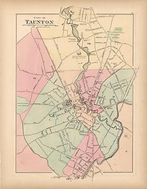
City of Taunton
Ańo de publicación: 1871
Librería: Art Source International Inc., Boulder, CO, Estados Unidos de America
Valoración del vendedor:
This hand-colored map is from Walling and Grays Official Topographical Atlas of Massachusetts from Astronomical, Trigonometrical, and Various Local Surveys published in 1871. This bright pastel map of the city of Taunton and its surrounding areas illustrates the street plan of the area. Details include rail lines, the names of neighborhoods, rail lines, lakes and rivers as well as important buildings. This map measures 15 inches by 10.5 inches.
-
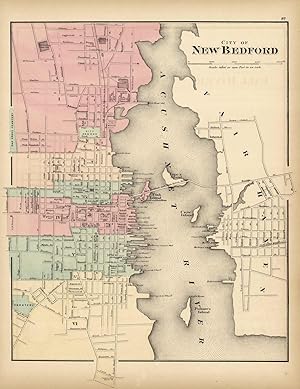
City of New Bedford
Ańo de publicación: 1871
Librería: Art Source International Inc., Boulder, CO, Estados Unidos de America
Valoración del vendedor:
This hand colored map is from Walling and Grays Official Topographical Atlas of Massachusetts from Astronomical, Trigonometrical, and Various Local Surveys published in 1871. This bright pastel map of the city of New Bedford and its surrounding areas illustrates the street plan of the area. Details include rail lines, the names of neighborhoods, rail lines, lakes and rivers as well as important buildings. This map measures 14.5 inches by 12 inches.
-
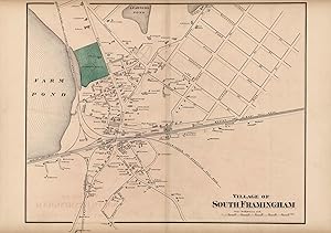
Village of South Framingham
Ańo de publicación: 1871
Librería: Art Source International Inc., Boulder, CO, Estados Unidos de America
Valoración del vendedor:
This hand colored map is from Walling and Grays Official Topographical Atlas of Massachusetts from Astronomical, Trigonometrical, and Various Local Surveys published in 1871. This map measures 17 inches by 20 inches.
-
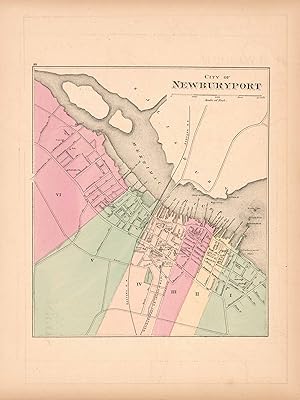
City of Newburyport, Mass
Ańo de publicación: 1871
Librería: Art Source International Inc., Boulder, CO, Estados Unidos de America
Valoración del vendedor:
This hand colored map is from Walling and Grays Official Topographical Atlas of Massachusetts from Astronomical, Trigonometrical, and Various Local Surveys published in 1871. This bright pastel map of Newburyport and its surrounding areas illustrates the street plan of the area. Details include rail lines, the names of neighborhoods,rail lines,lakes and rivers as well as important buildings. This map measures 11.25 inches by 10 inches.
-
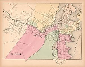
City of Salem
Ańo de publicación: 1871
Librería: Art Source International Inc., Boulder, CO, Estados Unidos de America
Valoración del vendedor:
This hand colored map is from Walling and Grays Official Topographical Atlas of Massachusetts from Astronomical, Trigonometrical, and Various Local Surveys published in 1871. This map measures 12.5 inches by 15.5 inches.
-
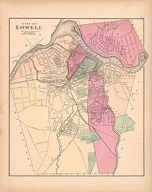
City of Lowell
Ańo de publicación: 1871
Librería: Art Source International Inc., Boulder, CO, Estados Unidos de America
Valoración del vendedor:
This hand colored map is from Walling and Grays Official Topographical Atlas of Massachusetts from Astronomical, Trigonometrical, and Various Local Surveys published in 1871. This bright pastel map of the City of Lowell and its surrounding areas illustrates the street plan of the area. Details include rail lines, the names of neighborhoods,rail lines,lakes and rivers as well as important buildings. This map measures 12 inches by 14 inches.
-

City of Lawrence
Ańo de publicación: 1871
Librería: Art Source International Inc., Boulder, CO, Estados Unidos de America
Valoración del vendedor:
This hand colored map is from Walling and Grays Official Topographical Atlas of Massachusetts from Astronomical, Trigonometrical, and Various Local Surveys published in 1871. This bright pastel map of the City of Lawrence and its surrounding areas illustrates the street plan of the area. Details include rail lines, the names of neighborhoods,rail lines,lakes and rivers as well as important buildings. This map measures 13.5 inches by 11.5 inches.
-
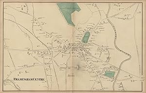
Framingham Centre
Ańo de publicación: 1871
Librería: Art Source International Inc., Boulder, CO, Estados Unidos de America
Valoración del vendedor:
This hand colored map is from Walling and Grays Official Topographical Atlas of Massachusetts from Astronomical, Trigonometrical, and Various Local Surveys published in 1871. This map measures 16 inches by 25 inches.
-
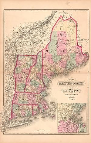
Map of New England with adjacent portions of New York & Canada
Ańo de publicación: 1871
Librería: Art Source International Inc., Boulder, CO, Estados Unidos de America
Valoración del vendedor:
This hand colored map is from Walling and Grays Official Topographical Atlas of Massachusetts from Astronomical, Trigonometrical, and Various Local Surveys published in 1871. Details include rail lines, city and county names, and lakes and rivers. Also included is an inset of the city Boston and surrounding area. This map measures 22 inches by 16 inches.
-
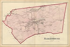
Town of Marlborough
Ańo de publicación: 1871
Librería: Art Source International Inc., Boulder, CO, Estados Unidos de America
Valoración del vendedor:
This hand-colored map is from Walling and Grays Official Topographical Atlas of Massachusetts from Astronomical, Trigonometrical, and Various Local Surveys published in 1871. This bright pastel map of the town of Marlborough and its surrounding areas illustrates the street plan of the area. Details include rail lines, the names of neighborhoods, rail lines, lakes and rivers as well as important buildings. This map measures 15.5 inches by 24 inches.
-
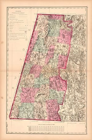
Map of Berkshire County, Massachusetts
Ańo de publicación: 1871
Librería: Art Source International Inc., Boulder, CO, Estados Unidos de America
Valoración del vendedor:
This hand colored map is from Walling and Grays Official Topographical Atlas of Massachusetts from Astronomical, Trigonometrical, and Various Local Surveys published in 1871. This bright pastel map is of Bershire County. Details include rail lines, county names, the names of important cities, major roads, lakes and rivers.Important land owners and businesses are also identified. This map measures 23 inches by 16 inches.
-
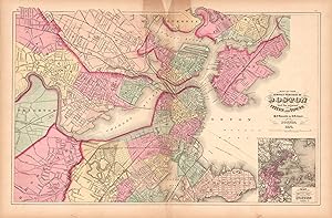
Map of the Compact Portions of Boston and the Adjacent Cities and Towns
Ańo de publicación: 1871
Librería: Art Source International Inc., Boulder, CO, Estados Unidos de America
Valoración del vendedor:
This hand colored map is from Walling and Grays Official Topographical Atlas of Massachusetts from Astronomical, Trigonometrical, and Various Local Surveys published in 1871. This bright pastel map of Boston and its surrounding areas illustrates the street plan of the area. Details include rail lines, the names of neighborhoods,rail lines,lakes and rivers as well as important buildings. An inset illustrates the present borders of Boston at a smaller scale. This map measures 15.25 inches by 23.5 inches.
-
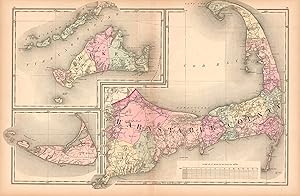
Map of Cape Cod
Ańo de publicación: 1871
Librería: Art Source International Inc., Boulder, CO, Estados Unidos de America
Valoración del vendedor:
This hand colored map is from Walling and Grays Official Topographical Atlas of Massachusetts from Astronomical, Trigonometrical, and Various Local Surveys published in 1871. This bright pastel map of Cape Cod identifies counties and important cities, water bodies, rivers, major roads and hills. Insets at the same scale illusrate Nantucket, the Elizabeth Islands and Dukes Island with the vineyard region identified. This map measures 16.5 inches by 23.5 inches.
