Importe total (1 artículo artículos):
Destino del pedido:

garcia cubas antonio 1832 1912 (12 resultados)
Tipo de artículo
- Todos los tipos de productos
- Libros (12)
- Revistas y publicaciones
- Cómics
- Partituras
- Arte, grabados y pósters
- Fotografías
- Mapas
- Manuscritos y coleccionismo de papel
Condición
Encuadernación
Más atributos
- Primera edición (3)
- Firmado
- Sobrecubierta
- Con imágenes (4)
- No impresión bajo demanda (9)
Gastos de envío gratis
- Gastos de Envío Gratis a EEUU
Ubicación del vendedor
Valoración de los vendedores
-
The Republic of Mexico in 1876 A Political and Ethnographical Division of the Population, Character, Habits, Costumes and Vocations of Its Inhabitants
Publicado por Hardpress Publishing, 2013
ISBN 10: 131435423XISBN 13: 9781314354232
Librería: PBShop.store US, Wood Dale, IL, Estados Unidos de America
Valoración del vendedor:

Libro
PAP. Condición: New. New Book. Shipped from UK. Established seller since 2000.
Más opciones de compra de otros vendedores en IberLibro
Nuevo desde EUR 19,85
Encuentre también Tapa blanda
-
MEMORIA PARA SERVIR Á LA CARTA GENERAL DEL IMPERIO MEXICANO Y DEMÁS NACIONES DESCUBIERTAS Y CONQUISTADAS POR LOS ESPAŃOLES DURANTE EL SIGLO 16 EN EL TERRITORIO PERTENECIENTE HOY Á LA REPÚBLICA MEXICANO.
Publicado por Legare Street Press, 2022
ISBN 10: 1016741332ISBN 13: 9781016741330
Librería: KALAMO LIBROS, S.L., La Puebla de Montalbán, TO, Espańa
Valoración del vendedor:

Libro Impresión bajo demanda
Encuadernación de tapa blanda. Condición: Nuevo. IMPRESIÓN BAJO DEMANDA / PRINT ON DEMAND.
-
![Imagen del vendedor de Étude géographique, statistique, descriptive et historique des États Unis Mexicains [Reprint] (1889)[Leatherbound] a la venta por S N Books World](https://pictures.abebooks.com/inventory/md/md30702617593.jpg)
Étude géographique, statistique, descriptive et historique des États Unis Mexicains [Reprint] (1889)[Leatherbound]
Publicado por Pranava Books, 2020
Libro Impresión bajo demanda
Leatherbound. Condición: NEW. Leatherbound edition. Condition: New. Language: fre Leather Binding on Spine and Corners with Golden leaf printing on spine. Reprinted from 1889 edition. NO changes have been made to the original text. This is NOT a retyped or an ocr'd reprint. Illustrations, Index, if any, are included in black and white. Each page is checked manually before printing. As this print on demand book is reprinted from a very old book, there could be some missing or flawed pages, but we always try to make the book as complete as possible. Fold-outs, if any, are not part of the book. If the original book was published in multiple volumes then this reprint is of only one volume, not the whole set. IF YOU WISH TO ORDER PARTICULAR VOLUME OR ALL THE VOLUMES YOU CAN CONTACT US. Sewing binding for longer life, where the book block is actually sewn (smythe sewn/section sewn) with thread before binding which results in a more durable type of binding. THERE MIGHT BE DELAY THAN THE ESTIMATED DELIVERY DATE DUE TO COVID-19. Pages: 348 Pages: 348.
-

MEMORIA PARA SERVIR Á LA CARTA GENERAL DEL IMPERIO MEXICANO Y DEMÁS NACIONES DESCUBIERTAS Y CONQUISTADAS POR LOS ESPAŃOLES DURANTE EL SIGLO 16 EN EL TERRITORIO PERTENECIENTE HOY Á LA REPÚBLICA MEXICANO.
Publicado por Legare Street Press, 2022
ISBN 10: 1016734891ISBN 13: 9781016734899
Librería: KALAMO LIBROS, S.L., La Puebla de Montalbán, TO, Espańa
Valoración del vendedor:
Libro Impresión bajo demanda
Encuadernación de tapa dura. Condición: Nuevo. IMPRESIÓN BAJO DEMANDA / PRINT ON DEMAND.
-

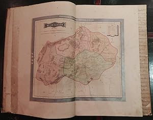
ATLAS METODICO PARA LA ENSENANZA DE LA GEOGRAFIA DE LA REPUBLICA MEXICANA
Publicado por Sandoval & Vazquez Impresores, Mexico City, 1874
Librería: Terra Firma Books, San Diego, CA, Estados Unidos de America
Valoración del vendedor:
Libro
Hardcover. Condición: Good. By the most important cartographer in Mexican history! Contains all 33 maps as called for. Borders hand-colored. Each map with a page of description. Small hole not affecting text. Measures 7x11"/18x28cm. New binding. No name or writing. RAR E!.
-
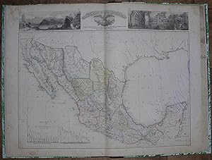
Atlas Geográfico de los Estados Unidos Mexicanos: Obra compuesta de 30 cartas de los estados, Distrito Federal y territorios de la Baja California y Tepic
Publicado por Mexico: Cadena y Ca., 1897., 1897
Librería: Arader Galleries - AraderNYC, New York, NY, Estados Unidos de America
Valoración del vendedor:
Folio (21 x 14 inches). 30 double-page chromolithograph regional maps of Mexico, each within broad silver border and fully colored, each map with integral finger tab titled in contemporary manuscript (title-page excised, quite browned). Contemporary half brown sheep, black cloth, gilt (very worn). Provenance: Contemporary ink stamp of G. Águila on verso of each map; with Dorothy Sloan, December 11th, 2009, lot 16 Exceptionally rare, in any condition, first published in 1886 by Debray under the same title, but with the addition of the silver borders which obscure the original 1886 title and imprint that are part of the original plate. Only two copies recorded on OCLC: UT Austin (Benson) and Getty. Each regional map is very detailed, with a key to towns, haciendas, ranchos, mines, anchorages, roads, and railroads, waterways, lakes, soundings, and mountain ranges. The map of the Federal District is decorated with eight vignettes showing floor plans of several buildings, Mexico City in pre-Hispanic times, a modern street plan, and Mexican antiquities. Several of the maps also have insets, such as the one of Guerrero, which has an inset of the "Puerto de Acapulco," and Sinaloa, with an inset of "Mazatlán." Recent realignments of state borders are labelled and shown in red (e.g. Nuevo León). "This atlas is emblematic of the progress and development in Mexico during Porfirio Díaz's tenure as President. One such feature, for example, is the depiction of railroads, either existing or under consideration. As the map of Oaxaca shows, the elusive cross-Tehuantepec road is still "en estudio"; by contrast, Puebla is well served at this time by railways both public and private. The fine details of each map and the excellent workmanship reflect not only progress in defining and developing Mexico's geography but also embody the height of late nineteenth-century Mexican lithographic art" (Dorothy Sloan). Palau 98722. Phillips, Atlases 2687. Rumsey 5758. For more information about these maps, or a warm welcome to see them and other books in our library at 72nd Street, NYC, please contact Kate Hunter, M.A. Oxon, in the Rare Book Department.
-
Atlas Geografico, Estadistico é Historico de la Republica Mexicana.
Publicado por Mexico: Imprenta de José Mariano Fernandez de Lara, 1858., 1858
Librería: Arader Galleries - AraderNYC, New York, NY, Estados Unidos de America
Valoración del vendedor:
Original o primera edición
"Folio, (22 Ľ x 15 inches). 28 fine double-page lithographed maps, with original hand-color in part; 2 maps from Mesoamerican pictorial manuscripts, one of which is hand-colored (occasional staining and spotting). Modern quarter black calf, marbled boards, gilt-lettered spine. "The first great atlas of Mexico, produced by a Mexican and printed in Mexico. Sabin says only 300 copies were printed" (Rumsey). First edition. Map 1 "Carta General Reducida," Map 17 "Mexico (Valle y Distrito de)," and Map 19 "Veracruz" not present. The general map of the republic of Mexico showing the boundaries created by the treaty of Guadeloupe Hidalgo of 1848 and the Gadsden Purchase of 1853. This is the first official map of Mexico, printed in Mexico and prepared from Mexican sources. 27 maps of states and territories surrounded by letterpress: Sonora, Chihuahua, Coahuila, Nuevo Leon, Tamaulipas, San Luis Potosi, Zacatecas, Aguascalientes, Durango, Sinaloa, Jalisco, Guanajuato, Mexico, Michoacan, Queretaro, Puebla, Guerrero, Oaxaca, Chiapas, Tabasco, Yucatan, Baja California, Colima, Tlaxcala, Tehuantepec, Territorios de Sierragorda, and Isla del Carmen. A few of the maps in this copy are misnumbered or bound out of order with respect to the Table of Contents. "[T]he SMGE's new national map, hastily finished in the aftermath of the War and during the initial phases of the boundary demarcation, appeared in 1850It included a visual elaboration of the territory lost in the Treaty of Guadalupe-Hidalgo, as well as a demarcation of the new international limits between Mexico and the United States[According to Garcia Cubas in his 'El Libro de mis recuerdos' (p.452)], the image brought an expression of bitterness from General Santa Anna, who for the first time could actually envision the magnitude of the territory Mexico had lost. The map never saw publication because of the government's precarious financial condition after the war. Members of the Comision and [SMGE] sought publishers in the United States and England, but found the prices for publication no more accommodating than Mexico "The need for a published and circulated, Mexican-produced, national map became even more pronounced when in 1854, Mexico lost another portion of its territorial claim as a result of errors in the Disturnell map. . . . Regardless of the role General Antonio Lopez de Santa Anna and others played in the politics of the [Gadsden] Purchase, Mexican officials and intellectuals were convinced: Mexico needed an accurate and internationally accepted map of its own, published and circulated. "After the war, a new Carta General, constructed by Garcia Cubas, would proffer an iconographic image of the state's new parameters and fill that territory with the ghosts of the past, in the process creating an image of a single national spirit" (Craib, "Cartographic Mexico," pp. 25-27).".
-
Atlas geografico e historico de la Republica Mexicana, Formado por Antonio Garcia y Cubas
Publicado por Mexico: Imprenta de Jose Mariano Fernandez de Lara, Calle de la Palma numero 4, 1858., 1858
Librería: Arader Galleries - AraderNYC, New York, NY, Estados Unidos de America
Valoración del vendedor:
"Folio (21 6/8 x 15 inches). 31 double-page litographed maps all with original hand-colour in part, or in outline, and 2 maps from Mesoamerican pictorial manuscripts, one of which is hand-coloured. Contemporary red calf backed marbled paper boards, vellum corners, gilt (a bit worn at the extremities). Provenance: with the manuscript ownership inscription of the Hackley Public Library on the verso of the title-page and inialled on the verso of each map, with their later book plates and other labels on the front paste-down. "The first great atlas of Mexico, produced by a Mexican and printed in Mexico. Sabin says only 300 copies were printed" (Rumsey). 2 general maps of the republic of Mexico, showing the boundaries created by the treaty of Guadeloupe Hidalgo of 1848 and the Gadsden purchase of 1853, and 29 maps of states and territories surrounded by letterpress: Sonora, Chihuahua, Coahuila, Nuevo Leon, Tamaulipas, San Luis Potosi, Zacatecas, Aguascalientes, Durango, Sinaloa, Jalisco, Guanajuato, Michoacan, Queretaro, Mexico (very spotted), Valle de Mexico, Puebla, Veracruz, Guerrero, Oaxaca, Chiapas, Tabasco, Yucatan, Baja California, Colima, Territorios de Sierragorda e Isla del Carmen, Tlaxcala, Tehuantepec. Garcia y Cubas was one of Mexico's greatest cartographers, "el fundador de nuestra geografía como ciencia" (Dicc. Porrúa) who published the first comprehensive atlas of Mexico (Atlas, Geographico, Estadistico e Historico de la Republica Mexicana) in 1858. "[T]he SMGE's new national map, hastily finished in the aftermath of the War and during the initial phases of the boundary demarcation, appeared in 1850It included a visual elaboration of the territory lost in the Treaty of Guadalupe-Hidalgo, as well as a demarcation of the new international limits between Mexico and the United States[According to Garcia Cubas in his 'El Libro de mis recuerdos' (p.452)], the image brought an expression of bitterness from General Santa Anna, who for the first time could actually envision the magnitude of the territory Mexico had lost. The map never saw publication because of the government's precarious financial condition after the war. Members of the Comision and [SMGE] sought publishers in the United States and England, but found the prices for publication no more accommodating than Mexico "The need for a published and circulated, Mexican-produced, national map became even more pronounced when in 1854, Mexico lost another portion of its territorial claim as a result of errors in the Disturnell map. . . . Regardless of the role General Antonio Lopez de Santa Anna and others played in the politics of the [Gadsden] Purchase, Mexican officials and intellectuals were convinced: Mexico needed an accurate and internationally accepted map of its own, published and circulated. "After the war, a new Carta General, constructed by Garcia Cubas, would proffer an iconographic image of the state's new parameters and fill that territory with the ghosts of the past, in the process creating an image of a single national spirit" (Craib, "Cartographic Mexico," pp. 25-27). Catalogued by Kate Hunter".
-
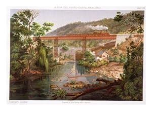
Album of the Mexican Railway. A Collection of Views taken from nature by Casmiro Castro
Publicado por Lithographic Establishment of Victor Debray and Co., Mexico, 1877
Librería: Arader Galleries - AraderNYC, New York, NY, Estados Unidos de America
Valoración del vendedor:
Original o primera edición
Oblong folio. Letterpress title-page in Spanish and English. Additional chromolithographic title-page and 24 numbered chromolithographic plates (plate 13 with long marginal tear and detached, plate 22 spotted, remains of original tissue guards), double-page chromolithographic map (long tear crossing the image on the left). Original cloth (detached, worn, and torn with loss, faded and soiled). First edition. "Some of the finest examples of the lithographer's art during the latter part of the century. Chromolithography by Debray y Cía of the work of Casimiro Castro and A. Sigogne illustrated Antonio García Cubas's extraordinary Album del Ferrocarril Mexicano" (Mathes). Casimiro Castro was a Mexican painter, draftsman and lithographer and is generally considered one of the greatest Mexican landscape artists and lithographers of the 19th century. His work on this album celebrates Mexico as it was undergoing modernization, epitomized by the advent of train transportation. Mathes, Mexico on Stone, pp. 41; Palau 48628.
-
Atlas Pintoresco é Historico de los Estados Unidos Mexicanos.
Publicado por [Mexico:] Debray Sucesores, 1885., 1885
Librería: Arader Galleries - AraderNYC, New York, NY, Estados Unidos de America
Valoración del vendedor:
Original o primera edición
Folio (24 2/8 x 16 inches). Fine double-page lithographic title-page and 13 EXCEPTIONALLY FINE double-page chromolithographic maps each with an elaborate border of vignettes depicting views and culture of the region and mounted on linen guards. Contemporary half green morocco, gilt, all edges gilt (extremities rubbed). Provenance: with a near contemporary gift inscription on the verso of the title-page dated 1st January 1890. First edition and an exceptionally attractive copy of this popular work by one of Mexico's greatest cartographers, "el fundador de nuestra geografía como ciencia" (Dicc. Porrúa) who published the first comprehensive atlas of Mexico (Atlas, Geographico, Estadistico e Historico de la Republica Mexicana) in 1858. Palau 98736.