Importe total (1 artículo artículos):
Destino del pedido:

collins capt greenville (3 resultados)
Ir a los resultados principales
Tipo de artículo
- Todo tipo de artículos
- Libros (3)
- Revistas y publicaciones
- Cómics
- Partituras
- Arte, grabados y pósters
- Fotografías
- Mapas
-
Manuscritos y
coleccionismo de papel
Condición
- Todo
- Nuevos
- Antiguos o usados
Encuadernación
- Todo
- Tapa dura
- Tapa blanda
Más atributos
- Primera edición
- Firmado
- Sobrecubierta
- Con imágenes del vendedor
- Sin impresión bajo demanda
Ubicación del vendedor
Valoración de los vendedores
-
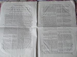
Great Britain's Coasting Pilot - text
Publicado por . ca, 1693
Librería: McLaren Books Ltd., ABA(associate), PBFA, Largs, Reino Unido
Miembro de asociación: ABA ILAB PBFA
Valoración del vendedor:

folio [50x34cm]. 16 pages [11-26]. disbound. good clean condition with a few edge tears and a central fold. the second part of the text portion of Capt.Collins' famous 'Great Britain's Coasting Pilot', containing sailing directions for the east coast of England from Harwich to Berwick-on-Tweed, and a Description of the East Coast of Scotland, with the Isles of Orkney and Shetland. in addition to the text, there is an inset chart of part of the Northumberland coast.
-
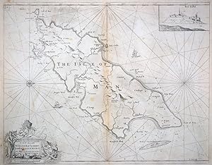
The Isle of Man.
Publicado por London, 1693-1738. 445 x 560mm (17˝ x 22 inches)., 1738
Librería: Tooley, Adams & Co., Wallingford, OXON, Reino Unido
Valoración del vendedor:
Uncoloured; slight overall age-toning, minor staining, also some light spotting mostly confirned to the margins, otherwise very good. Engraved by Herman Moll and published in Captain Greenville Collins' 'Great Britain's Coasting Pilot', as first state. A chart of the whole island, with inset of Peel Castle.
-
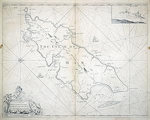
The Isle of Man.
Publicado por London, 1693-. 440 x 560mm (17Ľ x 22 inches)., 1693
Librería: Tooley, Adams & Co., Wallingford, OXON, Reino Unido
Valoración del vendedor:
Uncoloured; slight overall age-toning, minor soiling, also some spotting, mostly confined to the margins, otherwise very good. Engraved by Herman Moll and published in Captain Greenville Collins' 'Great Britain's Coasting Pilot', as first state. A chart of the whole island, with inset of Peel Castle.