Importe total (1 artículo artículos):
Destino del pedido:

brion tour desnos (106 resultados)
Ir a los resultados principales
Tipo de artículo
- Todo tipo de artículos
- Libros (48)
- Revistas y publicaciones
- Cómics
- Partituras
- Arte, grabados y pósters (4)
- Fotografías
- Mapas (54)
-
Manuscritos y
coleccionismo de papel
Condición
- Todo
- Nuevos
- Antiguos o usados
Encuadernación
- Todo
- Tapa dura (4)
- Tapa blanda
Más atributos
- Primera edición (1)
- Firmado (1)
- Sobrecubierta
- Con imágenes del vendedor (66)
- Sin impresión bajo demanda
Ubicación del vendedor
Valoración de los vendedores
-
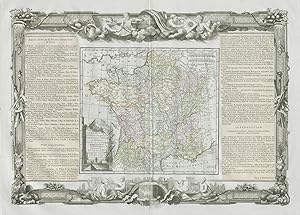
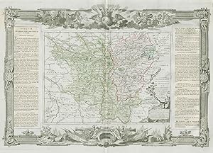
Condición: Good. "La France par Provinces Ecclésiastiques". DESNOS/DE LA TOUR 1771 old map. Antique eighteenth century copperplate atlas map with original hand colour, and ornate border. The flanking columns of descriptive text were stuck onto the sheet at the time of publication; Louis Brion de la Tour / Louis Desnos (1771). 56.5 x 44.0cm, 22.25 x 17.25 inches; this is a folding map. Condition: Good. There is nothing printed on the reverse side, which is plain. France, divided into Ecclestiastical provinces".
-
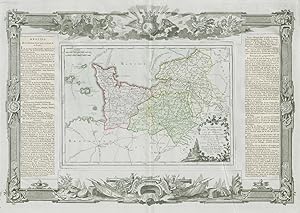
Condición: Good. "Gouvernemens de Normandie et du Havre". Normandy. DESNOS/DE LA TOUR 1771 map. Antique eighteenth century copperplate atlas map with original hand colour, and ornate border. The flanking columns of descriptive text were stuck onto the sheet at the time of publication; Louis Brion de la Tour / Louis Desnos (1771). 56.5 x 44.0cm, 22.25 x 17.25 inches; this is a folding map. Condition: Good. There is nothing printed on the reverse side, which is plain. Normandy including Le Havre, Rouen, Caen and Alençon.
-
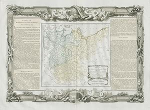
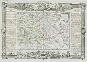
Condición: Good. "Les Duchés de Lorraine, Bar Metz, Toul et Verdun". DESNOS/DE LA TOUR 1771 map. Antique eighteenth century copperplate atlas map with original hand colour, and ornate border. The flanking columns of descriptive text were stuck onto the sheet at the time of publication; Louis Brion de la Tour / Louis Desnos (1771). 56.5 x 44.0cm, 22.25 x 17.25 inches; this is a folding map. Condition: Good. Spot. There is nothing printed on the reverse side, which is plain. The Duchies of Lorraine, and of Bar, and the Bishoprics of Metz, Toul, and Verdun. Eastern France".
-
Condición: Good. "Pays-Bas François, comprenant Flandre et d'Artois". DESNOS/DE LA TOUR 1771 map. Antique eighteenth century copperplate atlas map with original hand colour, and ornate border. The flanking columns of descriptive text were stuck onto the sheet at the time of publication; Louis Brion de la Tour / Louis Desnos (1771). 56.5 x 44.0cm, 22.25 x 17.25 inches; this is a folding map. Condition: Good. There is nothing printed on the reverse side, which is plain. The French low countries, comprising French Flanders (Nord) and Artois (Pas-de-Calais)".
-
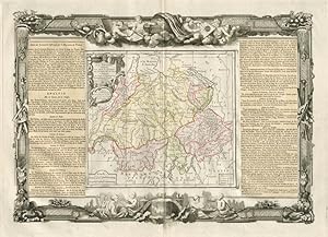
La Suisse, diviseé en ses Cantons, ses Alliés, et Sujčts, et. distinguée en Pays Catholiques, Protestans et Mixtes. Par le Sr. Brion, Ingénieur Géographe du Roy ŕ Paris, Chez le Sr. Desnos, Ingén. Géographe pour les Globes, et Sphéres, ruë St. Jacques au Globe. 1764
Ańo de publicación: 1771
Mapa
Condición: Good. "La Suisse". Switzerland. DESNOS/DE LA TOUR 1771 old antique map plan chart. Antique eighteenth century copperplate atlas map with original hand colour, and ornate border. The flanking columns of descriptive text were stuck onto the sheet at the time of publication; Louis Brion de la Tour / Louis Desnos (1771). 56.5 x 44.0cm, 22.25 x 17.25 inches; this is a folding map. Condition: Good. There is nothing printed on the reverse side, which is plain.
-
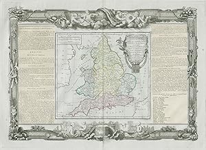
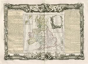
Condición: Good. "L'Angleterre divisée en 5 grandes parties". England. DESNOS/DE LA TOUR 1771 map. Antique eighteenth century copperplate atlas map with original hand colour, and ornate border. The flanking columns of descriptive text were stuck onto the sheet at the time of publication; Louis Brion de la Tour / Louis Desnos (1771). 56.5 x 44.0cm, 22.25 x 17.25 inches; this is a folding map. Condition: Good. There is nothing printed on the reverse side, which is plain. England, unusually divided into 5 major parts.
-
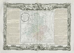
Cercles de Baviere, de Franconie et de Souabe: divisés en toutes leurs Principautés, et Provinces tant Séculičres qu'Ecclesiastiques. Par Mr. Brion Ingr.-Géographe du Roi. ŕ Paris Chez le Sr. Desnos Ing? Géog? pour les Globes et Sphčres, Ruë St. Jacques au Globe. 1766
Ańo de publicación: 1771
Mapa
Condición: Good. Cercles de Baviere, de Franconie et de Souabe Germany DESNOS/DE LA TOUR 1771 map. Antique eighteenth century copperplate atlas map with original hand colour, and ornate border. The flanking columns of descriptive text were stuck onto the sheet at the time of publication; Louis Brion de la Tour / Louis Desnos (1771). 56.5 x 44.0cm, 22.25 x 17.25 inches; this is a folding map. Condition: Good. There is nothing printed on the reverse side, which is plain. Circles of Bavaria, Franconia, and Swabia. Southern Germany.
-
Cercles de Westphalie, Haut et Bas Rhin, divisés en toutes leurs Principautés et Provinces, tant Séculičres qu'Ecclésiastiques. A Paris, Chéz le Sr. Desnos Ing? Géog? pour les Globes et Sphčres rüe Saint Jacques au Globe. 1766
Ańo de publicación: 1771
Mapa
Condición: Good. "Cercles de Westphalie, Haut et Bas Rhin". Germany. DESNOS/DE LA TOUR 1771 map. Antique eighteenth century copperplate atlas map with original hand colour, and ornate border. The flanking columns of descriptive text were stuck onto the sheet at the time of publication; Louis Brion de la Tour / Louis Desnos (1771). 56.5 x 44.0cm, 22.25 x 17.25 inches; this is a folding map. Condition: Good. There is nothing printed on the reverse side, which is plain. Westphalia, Upper and Lower Rhine. North West Germany. Hessen, Nordrhein-Westfalen, Bremen Niedersachsen & Rheinland-Pfalz.
-
Cercles de Haute et Basse Saxe, divisés, en toutes leurs Principautés et Provinces, tant Séculičres qu'Ecclésiastiques. A Paris, Chez le Sr. Desnos, Ingén. Géograph pour les Globes et Sphčres, Ruë St. Jacques au Globe. 1766
Ańo de publicación: 1771
Mapa
Condición: Good. "Cercles de Haute et Basse Saxe" Lower & Upper Saxony DESNOS/DE LA TOUR 1771 map. Antique eighteenth century copperplate atlas map with original hand colour, and ornate border. The flanking columns of descriptive text were stuck onto the sheet at the time of publication; Louis Brion de la Tour / Louis Desnos (1771). 56.5 x 44.0cm, 22.25 x 17.25 inches; this is a folding map. Condition: Good. There is nothing printed on the reverse side, which is plain. Circles of Upper and Lower Saxony. North East Germany: Brandenburg, Sachsen-Anhalt, Thuringen, mecklenburg-Vorpommern, Holstein & Bremen-Niederscachsen.
-
Le Danemark divisé par Provinces, et Diocčses sous une Métropole. Par le Sr. Brion. Ingénieur-Géographe du Roi. A Paris chez le Sr. Desnos. Ingenr pour les Globes et Sphéres, ruë St. Jacques au Globe. 1766
Ańo de publicación: 1771
Mapa
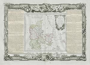
Condición: Good. "Le Danemark divisé par provinces ". Denmark. DESNOS/DE LA TOUR 1771 old map. Antique eighteenth century copperplate atlas map with original hand colour, and ornate border. The flanking columns of descriptive text were stuck onto the sheet at the time of publication; Louis Brion de la Tour / Louis Desnos (1771). 56.5 x 44.0cm, 22.25 x 17.25 inches; this is a folding map. Condition: Good. Blemish in margin. There is nothing printed on the reverse side, which is plain. Denmark divided by Provinces, and Dioceses".
-
Condición: Good. "Gouvernemens de Languedoc de Roussillon " Occitanie. DESNOS/DE LA TOUR 1771 map. Antique eighteenth century copperplate atlas map with original hand colour, and ornate border. The flanking columns of descriptive text were stuck onto the sheet at the time of publication; Louis Brion de la Tour / Louis Desnos (1771). 56.5 x 44.0cm, 22.25 x 17.25 inches; this is a folding map. Condition: Good. There is nothing printed on the reverse side, which is plain. Languedoc, Roussillon, Foix, and part of Guienne and Gascogne. Toulouse, Montpellier, Montauban, Perpignan, and Auch. Occitanie".
-
Condición: Good. Poitou, Berri, Bourbonnois & Nivernois. Pays / Loire. DESNOS/DE LA TOUR 1771 map. Antique eighteenth century copperplate atlas map with original hand colour, and ornate border. The flanking columns of descriptive text were stuck onto the sheet at the time of publication; Louis Brion de la Tour / Louis Desnos (1771). 56.5 x 44.0cm, 22.25 x 17.25 inches; this is a folding map. Condition: Good. There is nothing printed on the reverse side, which is plain. Poitou, Berry, Bourbonnais, and Nivernais.
-
Gouvernemens et Généralités de Bourgogne et de Franche-Comté. Corrigés, et augmentés de toutes les Routes avec les Distances en Lieuës d'usage dans ces Pays par Mr. Brion, I.G. du Roy 1771
Ańo de publicación: 1771
Mapa
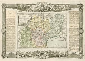
Condición: Good. "Gouvernemens de Bourgogne et de Franche-Comté". DESNOS/DE LA TOUR 1771 map. Antique eighteenth century copperplate atlas map with original hand colour, and ornate border. The flanking columns of descriptive text were stuck onto the sheet at the time of publication; Louis Brion de la Tour / Louis Desnos (1771). 56.5 x 44.0cm, 22.25 x 17.25 inches; this is a folding map. Condition: Good. There is nothing printed on the reverse side, which is plain. Burgundy and Franche-Comté".
-
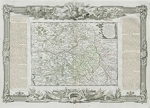
Condición: Good. Orléanois, Touraine, Maine, Anjou & Saumurois. Loire. DESNOS/DE LA TOUR 1771 map. Antique eighteenth century copperplate atlas map with original hand colour, and ornate border. The flanking columns of descriptive text were stuck onto the sheet at the time of publication; Louis Brion de la Tour / Louis Desnos (1771). 56.5 x 44.0cm, 22.25 x 17.25 inches; this is a folding map. Condition: Good. There is nothing printed on the reverse side, which is plain. Loire Valley. Orleans, Touraine, Maine, Anjou, and Saumurois.
-
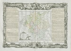
Condición: Good. "L'Alemagne divisée en tous ses cercles". Germany. DESNOS/DE LA TOUR 1771 map. Antique eighteenth century copperplate atlas map with original hand colour, and ornate border. The flanking columns of descriptive text were stuck onto the sheet at the time of publication; Louis Brion de la Tour / Louis Desnos (1771). 56.5 x 44.0cm, 22.25 x 17.25 inches; this is a folding map. Condition: Good. Spot. There is nothing printed on the reverse side, which is plain. Germany divided into all its circles.
-
Condición: Good. "L'Isle de France et de Champagne". Île-de-France. DESNOS/DE LA TOUR 1771 map. Antique eighteenth century copperplate atlas map with original hand colour, and ornate border. The flanking columns of descriptive text were stuck onto the sheet at the time of publication; Louis Brion de la Tour / Louis Desnos (1771). 56.5 x 44.0cm, 22.25 x 17.25 inches; this is a folding map. Condition: Good. There is nothing printed on the reverse side, which is plain. The Île de France and Champagne, including Paris and Chalons.
-
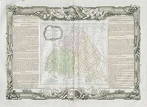
Les Isles Britanniques, assujetties aux observations astronomiques, combinées avec les itinéraires tant ancien, que moderne. Par le Sr. Brion, Ingénieur-Géographe du Roi. ŕ Paris, chez Desnos, Ingén? Géogr? pour les Globes et Sphčres, ruë St. Jacques, au Globe. 1766
Ańo de publicación: 1771
Mapa
Condición: Good. "Les Isles Britanniques". British Isles. DESNOS/DE LA TOUR 1771 old map. Antique eighteenth century copperplate atlas map with original hand colour, and ornate border. The flanking columns of descriptive text were stuck onto the sheet at the time of publication; Louis Brion de la Tour / Louis Desnos (1771). 56.5 x 44.0cm, 22.25 x 17.25 inches; this is a folding map. Condition: Good. There is nothing printed on the reverse side, which is plain. The British Isles.
-
Condición: Good. "Partie de l'Italie " Milan Parme Génes Italy Savoie. DESNOS/DE LA TOUR 1771 map. Antique eighteenth century copperplate atlas map with original hand colour, and ornate border. The flanking columns of descriptive text were stuck onto the sheet at the time of publication; Louis Brion de la Tour / Louis Desnos (1771). 56.5 x 44.0cm, 22.25 x 17.25 inches; this is a folding map. Condition: Good. There is nothing printed on the reverse side, which is plain. The continental part of the Kingdom of Sardinia, and the states of Milan, Parma, and Genoa. Present day north-western Italy, plus Savoie/Haute-Savoie and the Comté de Nice. The map covers much of the present day French and Italian Alps".
-
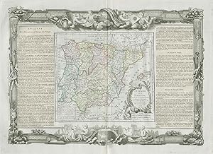
L'Espagne et le Portugal, divisés par Gouvernemens généraux et provinces Ecclésiastiques. Par le Sr. Brion, Ingr Géogr. du Roi, ŕ Paris, cher le Sr. Desnos, Ingr. Géog? Pour les Globes et Sphčres, rue St. Jacques, au Globe. 1766.
Ańo de publicación: 1771
Mapa
Condición: Good. "L'Espagne et le Portugal". Spain / Iberia. DESNOS/DE LA TOUR 1771 old map. Antique eighteenth century copperplate atlas map with original hand colour, and ornate border. The flanking columns of descriptive text were stuck onto the sheet at the time of publication; Louis Brion de la Tour / Louis Desnos (1771). 56.5 x 44.0cm, 22.25 x 17.25 inches; this is a folding map. Condition: Good. There is nothing printed on the reverse side, which is plain. Iberia: Spain and Portugal.
-

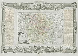
Les Gouvernamens de L'Isle de France et de Campagne et les generalites de Paris et de Chalons
Publicado por 1771, 1771
Librería: TABERNA LIBRARIA - ALAI - ILAB, Pistoia, Italia
Miembro de asociación: ALAI ILAB
Valoración del vendedor:

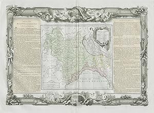
Acquaforte con bella e vivace coloritura coeva, cm. 39x55 alla battuta. Una ricca bordura decorativa a motivi floreali racchiude la mappa geografica e il descrittivo. Carta tratta da "Atlas Géneral, Civil et Ecclésiastique", Louis Brion de la Tour, 1771.
-
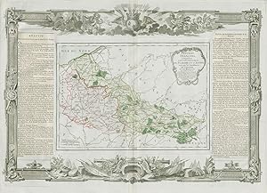
Les Gouvernamens de Languedoc, de Roussillon, de Foix .
Publicado por 1771, 1771
Librería: TABERNA LIBRARIA - ALAI - ILAB, Pistoia, Italia
Miembro de asociación: ALAI ILAB
Valoración del vendedor:
Acquaforte con bella e vivace coloritura coeva, cm. 39x55 alla battuta. Una ricca bordura decorativa a motivi floreali racchiude la mappa geografica e il descrittivo. Carta tratta da "Atlas Géneral, Civil et Ecclésiastique", Louis Brion de la Tour, 1771.
-
Gouvernament de Orleanois, de Touraine du Maine .
Publicado por 1771, 1771
Librería: TABERNA LIBRARIA - ALAI - ILAB, Pistoia, Italia
Miembro de asociación: ALAI ILAB
Valoración del vendedor:
Acquaforte con bella e vivace coloritura coeva, cm. 39x55 alla battuta. Una ricca bordura decorativa a motivi floreali racchiude la mappa geografica e il descrittivo. Carta tratta da "Atlas Géneral, Civil et Ecclésiastique", Louis Brion de la Tour, 1771.
-
Cercles de Westphalie, Haut et Bas Rhin.
Publicado por 1766, 1766
Librería: TABERNA LIBRARIA - ALAI - ILAB, Pistoia, Italia
Miembro de asociación: ALAI ILAB
Valoración del vendedor:
Acquaforte con bella e vivace coloritura coeva, cm. 39x55 alla battuta. Una ricca bordura decorativa a motivi floreali racchiude la mappa geografica e il descrittivo. Carta tratta da "Atlas Géneral, Civil et Ecclésiastique", Louis Brion de la Tour, 1766.
-
Gouvernament et Generalitč D'Alsace
Publicado por 1771, 1771
Librería: TABERNA LIBRARIA - ALAI - ILAB, Pistoia, Italia
Miembro de asociación: ALAI ILAB
Valoración del vendedor:
Acquaforte con bella e vivace coloritura coeva, cm. 39x55 alla battuta. Una ricca bordura decorativa a motivi floreali racchiude la mappa geografica e il descrittivo. Carta tratta da "Atlas Géneral, Civil et Ecclésiastique", Louis Brion de la Tour, 1771.
-
Gouvernaments d'Aunis, de Saintonge, de Limosin, .
Publicado por 1771, 1771
Librería: TABERNA LIBRARIA - ALAI - ILAB, Pistoia, Italia
Miembro de asociación: ALAI ILAB
Valoración del vendedor:
Acquaforte con bella e vivace coloritura coeva, cm. 39x55 alla battuta. Una ricca bordura decorativa a motivi floreali racchiude la mappa geografica e il descrittivo. Carta tratta da "Atlas Géneral, Civil et Ecclésiastique", Louis Brion de la Tour, 1771.
-
Gouvernament de Picardie, de Boulonnois, et d'Artois
Publicado por 1771, 1771
Librería: TABERNA LIBRARIA - ALAI - ILAB, Pistoia, Italia
Miembro de asociación: ALAI ILAB
Valoración del vendedor:
Acquaforte con bella e vivace coloritura coeva, cm. 39x55 alla battuta. Una ricca bordura decorativa a motivi floreali racchiude la mappa geografica e il descrittivo. Carta tratta da "Atlas Géneral, Civil et Ecclésiastique", Louis Brion de la Tour, 1771.
-
Pays-Bas François comprenant les Gouvernemens de Flandre et d'Artois .
Publicado por 1771, 1771
Librería: TABERNA LIBRARIA - ALAI - ILAB, Pistoia, Italia
Miembro de asociación: ALAI ILAB
Valoración del vendedor:
Acquaforte con bella e vivace coloritura coeva, cm. 39x55 alla battuta. Una ricca bordura decorativa a motivi floreali racchiude la mappa geografica e il descrittivo. Carta tratta da "Atlas Géneral, Civil et Ecclésiastique", Louis Brion de la Tour, 1771.
-
Cercles de Baviere, de Franconie et de Squabe
Publicado por 1766, 1766
Librería: TABERNA LIBRARIA - ALAI - ILAB, Pistoia, Italia
Miembro de asociación: ALAI ILAB
Valoración del vendedor:
Acquaforte con bella e vivace coloritura coeva, cm. 39x55 alla battuta. Una ricca bordura decorativa a motivi floreali racchiude la mappa geografica e il descrittivo. Carta tratta da "Atlas Géneral, Civil et Ecclésiastique", Louis Brion de la Tour, 1766.
-
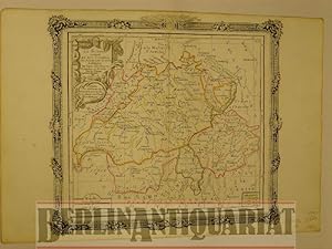
Schweiz. La Suisse. Divisée en ses Cantons, ses Alliés, et ses Sujets, et distinguée en Pays Catholiques, Protestans et Mixtes. Altkolorierter Kupferstich mit Grenzkolorit.
Publicado por ca. 1790., Paris, 1790
Librería: BerlinAntiquariat, Karl-Heinz Than, Berlin, Alemania
Miembro de asociación: ILAB VDA
Valoración del vendedor:

Mittig einmal gefaltet. Geringfügig randgebräunt. Gut erhalten. - Alte Landkarte. Carte ancienne. Old map of Switzerland. Contemp. col. Surrounded by decorative border. - Foto auf Anfrage. Mit einer ornamentalen Schmuckleiste eingefaßt. Bildgröße ca. 30 x 28 cm.
-
![Imagen del vendedor de Großbritannien [England]. Les Isles Britanniques. combinées avec les Itinéraires. Altkolorierter Kupferstich mit Grenzkolorit und zartem Flächenkolorit. a la venta por BerlinAntiquariat, Karl-Heinz Than](https://pictures.abebooks.com/inventory/md/md614916606.jpg)
Großbritannien [England]. Les Isles Britanniques. combinées avec les Itinéraires. Altkolorierter Kupferstich mit Grenzkolorit und zartem Flächenkolorit.
Publicado por Paris, 1798
Librería: BerlinAntiquariat, Karl-Heinz Than, Berlin, Alemania
Miembro de asociación: ILAB VDA
Valoración del vendedor:
Mit einer Kartusche und mit einer. Mittig einmal gefaltet. Geringfügig randgebräunt sowie am Rand geringfügig fleckig bzw. angeschmutzt. Kleine fehlstellige Ecke unten rechts. Sonst gut erhalten. - Alte Landkarte. Carte ancienne. Old map of the British isles. Contemp. col. Surrounded by decorative border. - Foto auf Anfrage. ornamentalen Schmuckleiste eingefaßt. Bildgröße ca. 30 x 28 cm.