Importe total (1 artículo artículos):
Destino del pedido:

admiralty staff intelligence division curata (1 resultados)
Ir a los resultados principales
Tipo de artículo
- Todo tipo de artículos
- Libros (1)
- Revistas y publicaciones
- Cómics
- Partituras
- Arte, grabados y pósters
- Fotografías
- Mapas
-
Manuscritos y
coleccionismo de papel
Condición
- Todo
- Nuevos
- Antiguos o usados
Encuadernación
- Todo
- Tapa dura
- Tapa blanda
Más atributos
- Primera edición
- Firmado
- Sobrecubierta
- Con imágenes del vendedor
- Sin impresión bajo demanda
Ubicación del vendedor
Valoración de los vendedores
-
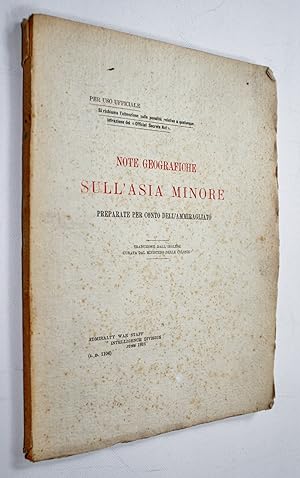
Note Geografiche Sull'Asia Minore preparate per conto dell' Ammiragliato (ID 1104).
Publicado por Admiralty, Ministero delle Colonie, London, Roma, 1917
Libro
Soft cover. Condición: Good. Original printed wraps 19 x 27cm. 89pp with folding map. Wraps good, foxed with creased edges, a couple of short tears to the spine with minor loss. Interiors very good, tanned with some spotting and light creasing. Map neatly folded without tears. Extremely rare - no OCLC or Copac reference found. Official Italian Ministry of the Colonies translated and edited version of the British Admiralty's "Notes on the Geography of Asia Minor" (ID 1104, June 1916, 59pp with a folding map), c 1917 (map date), marked for official use only and protected under Britain's Official Secrets Act. It would therefore coincide with the Agreement of Saint-Jean-de-Maurienne between France, Italy and Britain (signed 26 April, endorsed 18 Aug - 26 Sept 1917), which promised parts of Ottoman Anatolia to Italy (subsequently nullified at the Paris Peace Conference in 1919). It covers the Anatolian plateau, the Taurus and Anti-Taurus mountains, and access to the plateau by sea (Sections I-IV), and military history (V). The "Sketch Map of Asia Minor, showing approximate course of Roads and Railways" is an Italian facsimile of the British N. 458 - 1917.