
Importe total (1 artículo artículos):
Destino del pedido:

adam charles blacks general atlas (43 resultados)
Tipo de artículo
- Todos los tipos de productos
- Libros
- Revistas y publicaciones
- Cómics
- Partituras
- Arte, grabados y pósters (1)
- Fotografías
- Mapas (42)
- Manuscritos y coleccionismo de papel
Condición
Encuadernación
- Todas
- Tapa dura
- Tapa blanda
Más atributos
- Primera edición
- Firmado
- Sobrecubierta
- Con imágenes (43)
- No impresión bajo demanda (43)
Gastos de envío gratis
- Gastos de Envío Gratis a EEUU
Ubicación del vendedor
Valoración de los vendedores
-

Japan.
Ańo de publicación: 1895
Librería: theoldmapman, Weston super Mare, Reino Unido
Valoración del vendedor:

Mapa
Single sheet. Large coloured map, elegantly coloured in outline. Inset of Tokio environs. 29 x 39 cm.
-

Persia, Afghanistan & Beloochistan.
Ańo de publicación: 1895
Librería: theoldmapman, Weston super Mare, Reino Unido
Valoración del vendedor:
Mapa
Single sheet. Large coloured map, elegantly coloured in outline. 41 x 25 cm.
-

Canada: New Brunswick, Nova Scotia, & Quebec, Eastern Section.
Ańo de publicación: 1895
Librería: theoldmapman, Weston super Mare, Reino Unido
Valoración del vendedor:
Mapa
Single sheet. Large coloured map, elegantly coloured in outline. 28 x 41 cm.
-

Dominion of Canada.
Ańo de publicación: 1895
Librería: theoldmapman, Weston super Mare, Reino Unido
Valoración del vendedor:
Mapa
Single sheet. Large coloured map, elegantly coloured in outline. 39 x 27 cm.
-

Dominion of Canada, Central Provinces.
Ańo de publicación: 1895
Librería: theoldmapman, Weston super Mare, Reino Unido
Valoración del vendedor:
Mapa
Single sheet. Large coloured map, elegantly coloured in outline. 39.5 x 27 cm.
-

Switzerland
Ańo de publicación: 1895
Librería: theoldmapman, Weston super Mare, Reino Unido
Valoración del vendedor:
Mapa
Single sheet. Large coloured map, elegantly coloured in outline. 41.5 x 28 cm.
-

German Empire (East Sheet).
Ańo de publicación: 1895
Librería: theoldmapman, Weston super Mare, Reino Unido
Valoración del vendedor:
Mapa
Single sheet. Large coloured map, elegantly coloured in outline. 31 x 39.5 cm.
-

Canada: British Columbia, Athabasca and Alberta.
Ańo de publicación: 1895
Librería: theoldmapman, Weston super Mare, Reino Unido
Valoración del vendedor:
Mapa
Single sheet. Large coloured map, elegantly coloured in outline. 27 x 39.5 cm.
-

Flags of the World
Ańo de publicación: 1895
Librería: theoldmapman, Weston super Mare, Reino Unido
Valoración del vendedor:
Arte / Grabado / Póster
Single print. Original antique engraved plate. Standards of 51 countries. Sheet 33 x 45 cms.overall. 26 x 37 cm.
-

United States: Pennsylvania
Ańo de publicación: 1895
Librería: theoldmapman, Weston super Mare, Reino Unido
Valoración del vendedor:
Mapa
Single sheet. Original antique maps of the states on sheets 13 x 18 inches. The counties are defined with attractive colouring. Mountains, rivers and railroads are shown and many features are named. The printed area of each map differs slightly. Please see image. c30 x 39 cm.
-

United States: Louisiana and Arkansas
Ańo de publicación: 1895
Librería: theoldmapman, Weston super Mare, Reino Unido
Valoración del vendedor:
Mapa
Single sheet. Original antique maps of the states on sheets 13 x 18 inches. The counties are defined with attractive colouring. Mountains, rivers and railroads are shown and many features are named. The printed area of each map differs slightly. Please see image. c30 x 39 cm.
-

United States: Indiana and Ohio
Ańo de publicación: 1895
Librería: theoldmapman, Weston super Mare, Reino Unido
Valoración del vendedor:
Mapa
Single sheet. Original antique maps of the states on sheets 13 x 18 inches. The counties are defined with attractive colouring. Mountains, rivers and railroads are shown and many features are named. The printed area of each map differs slightly. Please see image. c30 x 39 cm.
-

United States: Michigan and Wisconsin
Ańo de publicación: 1895
Librería: theoldmapman, Weston super Mare, Reino Unido
Valoración del vendedor:
Mapa
Single sheet. Original antique maps of the states on sheets 13 x 18 inches. The counties are defined with attractive colouring. Mountains, rivers and railroads are shown and many features are named. The printed area of each map differs slightly. Please see image. c30 x 39 cm.
-

United States: Rhode island and Vermont
Ańo de publicación: 1895
Librería: theoldmapman, Weston super Mare, Reino Unido
Valoración del vendedor:
Mapa
Single sheet. Original antique maps of the states on sheets 13 x 18 inches. The counties are defined with attractive colouring. Mountains, rivers and railroads are shown and many features are named. The printed area of each map differs slightly. Please see image. c30 x 39 cm.
-
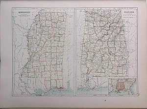
United States: Alabama and Mississippi
Ańo de publicación: 1895
Librería: theoldmapman, Weston super Mare, Reino Unido
Valoración del vendedor:
Mapa
Single sheet. Original antique maps of the states on sheets 13 x 18 inches. The counties are defined with attractive colouring. Mountains, rivers and railroads are shown and many features are named. The printed area of each map differs slightly. Please see image. c30 x 39 cm.
-

United States: Nebraska and Kansas
Ańo de publicación: 1895
Librería: theoldmapman, Weston super Mare, Reino Unido
Valoración del vendedor:
Mapa
Single sheet. Original antique maps of the states on sheets 13 x 18 inches. The counties are defined with attractive colouring. Mountains, rivers and railroads are shown and many features are named. The printed area of each map differs slightly. Please see image. c30 x 39 cm.
-

United States: Massachusetts
Ańo de publicación: 1895
Librería: theoldmapman, Weston super Mare, Reino Unido
Valoración del vendedor:
Mapa
Single sheet. Original antique maps of the states on sheets 13 x 18 inches. The counties are defined with attractive colouring. Mountains, rivers and railroads are shown and many features are named. The printed area of each map differs slightly. Please see image. c30 x 39 cm.
-

United States: Illinois
Ańo de publicación: 1895
Librería: theoldmapman, Weston super Mare, Reino Unido
Valoración del vendedor:
Mapa
Single sheet. Original antique maps of the states on sheets 13 x 18 inches. The counties are defined with attractive colouring. Mountains, rivers and railroads are shown and many features are named. The printed area of each map differs slightly. Please see image. c30 x 39 cm.
-

United States: Conneticut and Maryland
Ańo de publicación: 1895
Librería: theoldmapman, Weston super Mare, Reino Unido
Valoración del vendedor:
Mapa
Single sheet. Original antique maps of the states on sheets 13 x 18 inches. The counties are defined with attractive colouring. Mountains, rivers and railroads are shown and many features are named. The printed area of each map differs slightly. Please see image. c30 x 39 cm.
-

United States: New York
Ańo de publicación: 1895
Librería: theoldmapman, Weston super Mare, Reino Unido
Valoración del vendedor:
Mapa
Single sheet. Original antique maps of the states on sheets 13 x 18 inches. The counties are defined with attractive colouring. Mountains, rivers and railroads are shown and many features are named. The printed area of each map differs slightly. Please see image. c30 x 39 cm.
-

United States: North and South Carolina
Ańo de publicación: 1895
Librería: theoldmapman, Weston super Mare, Reino Unido
Valoración del vendedor:
Mapa
Single sheet. Original antique maps of the states on sheets 13 x 18 inches. The counties are defined with attractive colouring. Mountains, rivers and railroads are shown and many features are named. The printed area of each map differs slightly. Please see image. c30 x 39 cm.
-

United States: Georgia and Florida
Ańo de publicación: 1895
Librería: theoldmapman, Weston super Mare, Reino Unido
Valoración del vendedor:
Mapa
Single sheet. Original antique maps of the states on sheets 13 x 18 inches. The counties are defined with attractive colouring. Mountains, rivers and railroads are shown and many features are named. The printed area of each map differs slightly. Please see image. c30 x 39 cm.
-

United States: Kentucky and Tennessee
Ańo de publicación: 1895
Librería: theoldmapman, Weston super Mare, Reino Unido
Valoración del vendedor:
Mapa
Single sheet. Original antique maps of the states on sheets 13 x 18 inches. The counties are defined with attractive colouring. Mountains, rivers and railroads are shown and many features are named. The printed area of each map differs slightly. Please see image. c30 x 39 cm.
-

United States: Delaware and New Jersey
Ańo de publicación: 1895
Librería: theoldmapman, Weston super Mare, Reino Unido
Valoración del vendedor:
Mapa
Single sheet. Original antique maps of the states on sheets 13 x 18 inches. The counties are defined with attractive colouring. Mountains, rivers and railroads are shown and many features are named. The printed area of each map differs slightly. Please see image. c30 x 39 cm.
-

United States: Dakota and Minnesota
Ańo de publicación: 1895
Librería: theoldmapman, Weston super Mare, Reino Unido
Valoración del vendedor:
Mapa
Single sheet. Original antique maps of the states on sheets 13 x 18 inches. The counties are defined with attractive colouring. Mountains, rivers and railroads are shown and many features are named. The printed area of each map differs slightly. Please see image. c30 x 39 cm.
-

United States: Arizona and Utah
Ańo de publicación: 1895
Librería: theoldmapman, Weston super Mare, Reino Unido
Valoración del vendedor:
Mapa
Single sheet. Original antique maps of the states on sheets 13 x 18 inches. The counties are defined with attractive colouring. Mountains, rivers and railroads are shown and many features are named. The printed area of each map differs slightly. Please see image. c30 x 39 cm.
-

United States: California and Nevada
Ańo de publicación: 1895
Librería: theoldmapman, Weston super Mare, Reino Unido
Valoración del vendedor:
Mapa
Single sheet. Original antique maps of the states on sheets 13 x 18 inches. The counties are defined with attractive colouring. Mountains, rivers and railroads are shown and many features are named. The printed area of each map differs slightly. Please see image. c30 x 39 cm.
-

United States: Alaska
Ańo de publicación: 1895
Librería: theoldmapman, Weston super Mare, Reino Unido
Valoración del vendedor:
Mapa
Single sheet. Original antique map of the state on sheets 13 x 18 inches. Mountains, rivers and railroads are defined with attractive colouring and many features are named. Inset of the extent of the Aleutians. Reid House, Upper Ramparts and Fort Reliance (which is 8 miles south of the site of Dawson City) are shown, but gold was discovered only in 1896! The printed area of each map differs slightly. Please see image. c30 x 39 cm.
-

United States: Virginia and West Virginia
Ańo de publicación: 1895
Librería: theoldmapman, Weston super Mare, Reino Unido
Valoración del vendedor:
Mapa
Single sheet. Original antique maps of the states on sheets 13 x 18 inches. The counties are defined with attractive colouring. Mountains, rivers and railroads are shown and many features are named. The printed area of each map differs slightly. Please see image. c30 x 39 cm.
-

United States: Iowa and Missouri
Ańo de publicación: 1895
Librería: theoldmapman, Weston super Mare, Reino Unido
Valoración del vendedor:
Mapa
Single sheet. Original antique maps of the states on sheets 13 x 18 inches. The counties are defined with attractive colouring. Mountains, rivers and railroads are shown and many features are named. The printed area of each map differs slightly. Please see image. c30 x 39 cm.