
Importe total (1 artículo artículos):
Destino del pedido:

SWANSTON, GEORGE H (10 resultados)
Ir a los resultados principales
Tipo de artículo
- Todo tipo de artículos
- Libros (9)
- Revistas y publicaciones
- Cómics
- Partituras
- Arte, grabados y pósters (1)
- Fotografías
- Mapas
-
Manuscritos y
coleccionismo de papel
Condición
- Todo
- Nuevos
- Antiguos o usados
Encuadernación
- Todo
- Tapa dura
- Tapa blanda
Más atributos
- Primera edición
- Firmado
- Sobrecubierta
- Con imágenes del vendedor
- Sin impresión bajo demanda
Ubicación del vendedor
Valoración de los vendedores
-
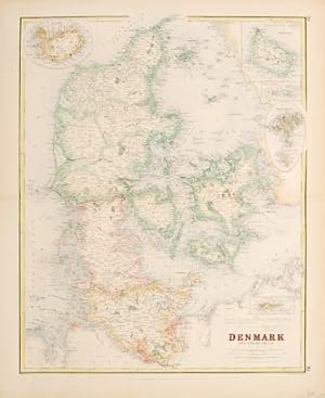
DENMARK and the Duchies.
Publicado por Gazetteer of the World. A. Fullarton & Co. 1860, 1860
Librería: Peter Harrington. ABA/ ILAB., London, Reino Unido
Miembro de asociación: ABA ILAB PBFA
Valoración del vendedor:

A detailed map of Denmark with five inset maps of Danish foreign territories of Iceland Santa Cruz, the Virgin Islands, Faroe Islands and Bornholm. Lithograph. Later colour. Fine condition. Size: 40 x 53cm. (15 x 21 inches).
-

SWITZERLAND.
Publicado por Edinburgh, London & Dublin. 1860, 1860
Librería: Peter Harrington. ABA/ ILAB., London, Reino Unido
Miembro de asociación: ABA ILAB PBFA
Valoración del vendedor:
Attractive and detailed map of Switzerland with a list of the main peaks below the title at top right. Gazetteer of the Worldpublished by Archibald Fullarton & Co. Lithograph. Later colour. Fine condition. Size: 52.8 x 40 cm.
-
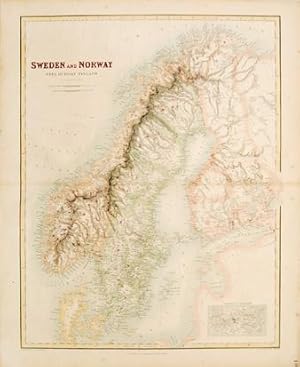
Sweden and Norway with Russian Finland.
Publicado por Atlas to Gazetteer of the World. Fullarton & Co. 1860, 1860
Librería: Peter Harrington. ABA/ ILAB., London, Reino Unido
Miembro de asociación: ABA ILAB PBFA
Valoración del vendedor:
A detailed map of Scandinavia with small inset entitled "Environs of Stockholm". Steel engraving. Original colour. In fine condition but with slight foxing on left-hand margin not affecting image. Size: 40.5 x 52.2 cm. (16 x 20˝ inches).
-
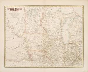
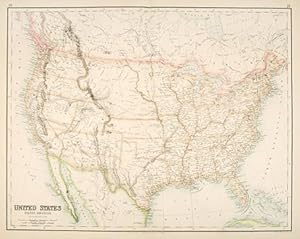
United States North America, The North Central Section Comprising Michigan, Illinois, Wisconsin, Iowa, Indiana, Nebraska, Minnisota and part of Missouri and Kentucky.
Publicado por Edinburgh, London & Dublin. 1860, 1860
Librería: Peter Harrington. ABA/ ILAB., London, Reino Unido
Miembro de asociación: ABA ILAB PBFA
Valoración del vendedor:
A detailed map of the United States from Nebraska in the west to Lake Huron in the east and Missouri in the south to Lake Superior in the north. Gazetteer of the World. A Fullarton & Co. Lithograph. Later colour. In fine condition but with previous restoration to small hole near centre fold Size: 51.6 x 40 cm. (20˝ x 15˝ inches).
-
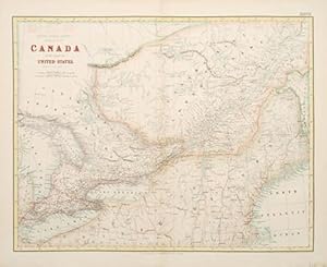
Canada British North America Sheet II, west. Canada with part of the United States.
Publicado por Edinburgh, London & Dublin. 1860, 1860
Librería: Peter Harrington. ABA/ ILAB., London, Reino Unido
Miembro de asociación: ABA ILAB PBFA
Valoración del vendedor:
A detailed map of nineteenth-century Canada. Published in the Gazetteer of the World by Archibald Fullarton & Co. Lithograph. Original colour with later additions. Fine condition. Size: 41 x 53 cm.
-

United States North America, The North Central Section Comprising Michigan, Illinois, Wisconsin, Iowa, Indiana, Nebraska, Minnisota and part of Missouri and Kentucky.
Publicado por Gazetteer of the World. A Fullarton & Co. 1860, 1860
Librería: Peter Harrington. ABA/ ILAB., London, Reino Unido
Miembro de asociación: ABA ILAB PBFA
Valoración del vendedor:
A detailed map of the states of the Mid West of the United States. Gazetteer of the World. A Fullarton & Co. Original lithograph. Later colouring. In fine condition but with previous restoration to small hole near centre fold Size: 51.6 x 40 cm. (20˝ x 15˝ inches).
-
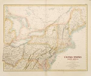
United States North America, The North Eastern States Comprising Maine, New Hampshire, Vermont, New York, Massachusetts, Rhode Id., Connecticut, New Jersey, Delaware, Pennsylvania, Maryland, Ohio, and part of Virginia & Michigan
Publicado por London & Dublin. 1860, 1860
Librería: Peter Harrington. ABA/ ILAB., London, Reino Unido
Miembro de asociación: ABA ILAB PBFA
Valoración del vendedor:
A detailed map of this area of the North Eastern portion of the United States. Gazetteer of the World. A Fullarton & Co. Lithograph. Later colour. Fine condition, some repair work to lower central fold. Size: 52.8 x 40 cm. (21 x 15˝ inches).
-
Condición: ACEPTABLE. Atlas to Gazetteer of World ; Eng. By G.H. Swanston. Edinburgh . Suavemente sombreado a color. Canto derecho dorado. (2) -J- Formato (cm): 57x47.
-

TURKEY; CENTRAL MEDITERRANEAN REGIONS. 7.
Publicado por London, Edinburgh & Dublin. 1860, 1860
Librería: Peter Harrington. ABA/ ILAB., London, Reino Unido
Miembro de asociación: ABA ILAB PBFA
Valoración del vendedor:
Two maps on one sheet, the first showing The Grecian Archipelago, the second showing Constantinople. Decorative vignettes showing local scenes, people and fauna border the two.The Royal Illustrated Atlas of Modern Geography, published Archibald Fullarton & Co. Steel engraving. Original colour. In fine condition. Size: 30 x 44 cm.
-
UNITED STATES NORTH AMERICA. LV.
Publicado por Edinburgh, London & Dublin. 1860, 1860
Librería: Peter Harrington. ABA/ ILAB., London, Reino Unido
Miembro de asociación: ABA ILAB PBFA
Valoración del vendedor:
A detailed map of the United States of America. Archibald Fullarton's Royal Illustrated Atlas of Modern Geography was the last highly decorative atlas published in England, and the maps are much sought after as a consequence. Steel engraving. Original colour. In good condition. Worm hole in middle of central fold. Size: 52.5 x 41 cm.