
Importe total (1 artículo artículos):
Destino del pedido:

PORCACCHI DA CASTIGLIONE, THOMASO (12 resultados)
Ir a los resultados principales
Tipo de artículo
- Todo tipo de artículos
- Libros (12)
- Revistas y publicaciones
- Cómics
- Partituras
- Arte, grabados y pósters
- Fotografías
- Mapas
-
Manuscritos y
coleccionismo de papel
Condición
Encuadernación
- Todo
- Tapa dura (2)
- Tapa blanda
Más atributos
- Primera edición (1)
- Firmado
- Sobrecubierta
- Con imágenes del vendedor (11)
- Sin impresión bajo demanda (11)
Gastos de envío gratis
Ubicación del vendedor
Valoración de los vendedores
-

Descripcion De La Gran Ciudad e Isla Temistitan. Traduccion de Luz Maria Ziaurriz. Version, Prologo y Notas de Andres Henestrosa.
Publicado por Mexico, D. F.: Miguel Angel Porrua, S.A., 1980
Librería: Zubal-Books, Since 1961, Cleveland, OH, Estados Unidos de America
Valoración del vendedor:

Condición: Fine. edition limited to 500 copies, 25 pp., mostly unopened, illustrated, marbled endpapers, original sailcloth or canvas with gilt stamped leather label to blind stamped decorated coverlower outer corner slightly frayed, else near fine. - If you are reading this, this item is actually (physically) in our stock and ready for shipment once ordered. We are not bookjackers. Buyer is responsible for any additional duties, taxes, or fees required by recipient's country.
-
![Imagen del vendedor de La historia d'Italia .: nuouamente rescontrata con tutti gli altri historici & auttori, che dell'istesse cose habbiano scritto: & ornata in margine con l'annotationi de' riscontri fatti da Thomaso Porcacchi da Castiglione Arretino. Con un Guidicio fatto dal medesimo, per discoprir tutte le bellezze di questa Historia: & una Raccolta di tutte le sententie sparse per l'opera: et con due tauole: una de gli auttori citati in margine; & l'altra delle cose notabili [LeatherBound] a la venta por True World of Books](https://pictures.abebooks.com/inventory/md/md31533412047.jpg)
La historia d'Italia .: nuouamente rescontrata con tutti gli altri historici & auttori, che dell'istesse cose habbiano scritto: & ornata in margine con l'annotationi de' riscontri fatti da Thomaso Porcacchi da Castiglione Arretino. Con un Guidicio fatto dal medesimo, per discoprir tutte le bellezze di questa Historia: & una Raccolta di tutte le sententie sparse per l'opera: et con due tauole: una de gli auttori citati in margine; & l'altra delle cose notabili [LeatherBound]
Ańo de publicación: 2023
Libro Impresión bajo demanda
LeatherBound. Condición: New. LeatherBound edition. Condition: New. Reprinted from 1574 edition. Leather Binding on Spine and Corners with Golden leaf printing on spine. Bound in genuine leather with Satin ribbon page markers and Spine with raised gilt bands. A perfect gift for your loved ones. NO changes have been made to the original text. This is NOT a retyped or an ocr'd reprint. Illustrations, Index, if any, are included in black and white. Each page is checked manually before printing. As this print on demand book is reprinted from a very old book, there could be some missing or flawed pages, but we always try to make the book as complete as possible. Fold-outs, if any, are not part of the book. If the original book was published in multiple volumes then this reprint is of only one volume, not the whole set. Sewing binding for longer life, where the book block is actually sewn (smythe sewn/section sewn) with thread before binding which results in a more durable type of binding. Pages: 1314 Language: Italian.
-

ISOLE SELANDIE. Islands of Zeeland.
Publicado por Venice: L'Isole Piu Famoso del Mondo. Simon Galignani. 1590, 1590
Librería: Peter Harrington. ABA/ ILAB., London, Reino Unido
Miembro de asociación: ABA ILAB PBFA
Valoración del vendedor:
Map of islands of southern Dutch coast before dykes were built and land reclaimed. The maps for this atlas were engraved by Girolamo Porro from Padua, and are set within a page of text, with engraved headpiece and decorated initial. There were many editions of this popular atlas between 1576 and 1713. Moreland and Bannister, p.68 Copper engraving. Uncoloured. A fine, crisp impression. Fine condition. leaf size:197 x 297mm. Size: 14 x 10.5 cm. (5˝ x 4 inches).
-

HOLLANDA. The Netherlands.
Publicado por Venice: L'Isole Piu Famoso del Mondo. Simon Galignani. 1590, 1590
Librería: Peter Harrington. ABA/ ILAB., London, Reino Unido
Miembro de asociación: ABA ILAB PBFA
Valoración del vendedor:
Map of Holland before any dykes were built and land reclaimed, showing all the original islands, Title cartouche. The maps for this atlas were engraved by Girolamo Porro from Padua, and are set within a page of text, with engraved headpiece and decorated initial. There were many editions of this popular atlas between 1576 and 1713. Moreland and Bannister, p.68 Copper engraving. Uncoloured. A fine, crisp impression. Fine condition. leaf size:197 x 297mm. Size: 14 x 10.5 cm. (5˝ x 4 inches).
-
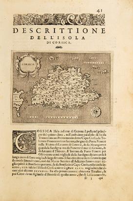
Corsica 41.
Publicado por Venice: L'Isole Piu Famoso del Mondo. Simon Galignani. 1590, 1590
Librería: Peter Harrington. ABA/ ILAB., London, Reino Unido
Miembro de asociación: ABA ILAB PBFA
Valoración del vendedor:
A pretty, if disproportionate map of the island with title cartouche, and Porcacci's characteristic sea monsters Morland and Bannister, p68 Copper engraving. Uncoloured. Fine condition, a fine, crisp impression. Size: 14.7 x 10.8 cm. (6 x 4˝ inches).
-
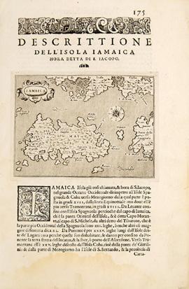
IAMAICA. Jamaica.
Publicado por Venice: L'Isole Piu Famoso del Mondo. Simon Galignani. 1590, 1590
Librería: Peter Harrington. ABA/ ILAB., London, Reino Unido
Miembro de asociación: ABA ILAB PBFA
Valoración del vendedor:
Map of Jamaica with decorated cartouche and sea monster. The maps for this atlas were all engraved by Girolamo Porro from Padua, and are set within a page of text, with engraved headpiece and decorated initial. There were many editions of this popular atlas between 1576 and 1713. Moreland & Bannister, p.68. Copper engraving. Uncoloured. A fine, crisp impression, water stain on lower margin, not affecting map. Very good condition. Leaf size: 197 x 297mm. Size: 140 x105 mm. (5˝ x 4 inches).
-
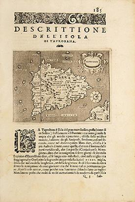
TAPROBANA. Sri Lanka.
Publicado por Venice: L'Isole Piu Famoso del Mondo. Simon Galignani. 1590, 1590
Librería: Peter Harrington. ABA/ ILAB., London, Reino Unido
Miembro de asociación: ABA ILAB PBFA
Valoración del vendedor:
Map of Sri Lanka with title cartouche at top right, compass points north to the right of map. The maps for this atlas were engraved by Girolamo Porro from Padua, and are set within a page of text, with engraved headpiece and decorated initial. There were many editions of this popular atlas between 1576 and 1713. Moreland & Bannister, p.68 Copper engraving. Uncoloured. A fine, crisp impression. Fine condition. leaf size:197 x 297mm. Size: 14 x 10.5 cm. (5˝ x 4 inches).
-
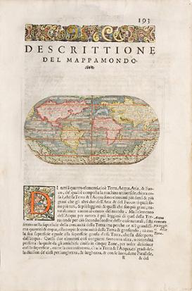
MAPPA MONDO.
Publicado por Venice: L'Isole Piu Famoso del Mondo. 1590, 1590
Librería: Peter Harrington. ABA/ ILAB., London, Reino Unido
Miembro de asociación: ABA ILAB PBFA
Valoración del vendedor:
A pretty oval map of the world. The maps for this atlas were engraved by Girolamo Porro from Padua, and are set within a page of text, with engraved headpiece and decorated initial. There were many editions of this popular atlas between 1576 and 1713. Moreland and Bannister, p.68 Size: 145 x 240 mm. Mounted size: 300 x 400 mm. Copper engraving. Later colour. A fine, crisp impression. Fine condition.
-
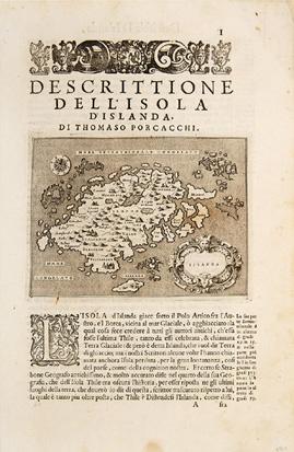
ISLANDA. Iceland.
Publicado por Venice: L'Isole Piu Famoso del Mondo. Simon Galignani. 1590, 1590
Librería: Peter Harrington. ABA/ ILAB., London, Reino Unido
Miembro de asociación: ABA ILAB PBFA
Valoración del vendedor:
Small map of Iceland, that shows the island surrounded by a frozen sea - 'mare congelato'. Decorated cartouche compass point. The maps for this atlas were engraved by Girolamo Porro from Padua, and are set within a page of text, with engraved headpiece and decorated initial. There were many editions of this popular atlas between 1576 and 1713. Moreland & Bannister, p.68. Copper engraving. Uncoloured. A fine, crisp impression. Fine condition. leaf size:197 x 297mm. Size: 14 x 10.5 cm. (5˝ x 4 inches).
-
CARTA DA NAVIGARE. World Map for mariners.
Publicado por Venice: L'Isole Piu Famoso del Mondo. Simon Galignani. 1590, 1590
Librería: Peter Harrington. ABA/ ILAB., London, Reino Unido
Miembro de asociación: ABA ILAB PBFA
Valoración del vendedor:
Attractive world map, a mariner's map with rhumb lines emanating from 16 points. The maps for this atlas were engraved by Girolamo Porro from Padua, and are set within a page of text, with engraved headpiece and decorated initial. There were many editions of this popular atlas between 1576 and 1713. Moreland and Bannister, p.68 Size:197 x 297 mm. Copper engraving. Hand coloured. Closed tear on lower margin of leaf not affecting map. Very good condition.
-
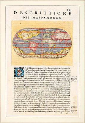
DESCRITTIONE DEL MAPPA MONDO.
Publicado por Venice: L'Isole Piu Famoso del Mondo. Simon Galignani. 1590, 1590
Librería: Peter Harrington. ABA/ ILAB., London, Reino Unido
Miembro de asociación: ABA ILAB PBFA
Valoración del vendedor:
Oval map of the world. The maps for this atlas were engraved by Girolamo Porro from Padua, and are set within a page of text, with engraved headpiece and decorated initial. There were many editions of this popular atlas between 1576 and 1713. Moreland and Bannister, p.68 Size:197 x 297 mm. Copper engraving. Hand coloured. A fine, crisp impression. Fine condition.
-
L'isole piu famose del Mondo. Arettino e intagliate da Girolamo Porro Padovano. Con l'aggiunta di molte isole all' ill.re s. conte Georgio Trivltio. - [THE CULMINATION OF THE "BOOK OF ISLANDS"]
Librería: Lynge & Sřn ILAB-ABF, Copenhagen, Dinamarca
Miembro de asociación: ILAB
Valoración del vendedor:

Original o primera edición
Venetia [Venice], apresso gli heredi di S. Gagliani, 1590. [Colophon: In Vintia, appresso Giorgio Angelieri, a instantia de gli heredi di Simon Gagliani de Karera, 1590]. Small folio. 18th century (ab. 1780-90) half vellum with gilt leather title label to spine. Corners a bit bumped and title label a bit worn, otherwise nice and tight. A very nice copy, on thick, crisp paper. A few quires browned and brownspotted, and some occasional lighter browning. Four leaves with a marginal worm-tract, far from affecting text. Beautiful engraved title-page, consisting of a wide architectural border illustrated with large figures, putti, globes, and various symbols. Beautiful large woodcut initials and head- and tail-pieces. 47 half-page engraved maps in the text (by Porro, of islands and continents), excellent, crisp impressions. Large woodcut device to colophon. (12) ff., 201, (1) pp. Third, much enlarged edition (with 47 maps as opposed to the mere 30 of the first edition) of Porcacchi's great book of islands, arguably the most famous of all "isolario"s, with the 47 finely engraved maps by the famous map-maker Girolamo Porro, which also include maps of non-insular places, e.g North America and Mexico City, the famous city plan of Venice and that of Constantinople. Porcachhi's great "isolario" represents the culmination of the "book of islands"-genre, both in regards to artistic quality and the information provided. It furthermore constitutes a main work in the history of the published knowledge of farther parts of the world and an important link in the development from what we call the "book of islands" to the modern atlas. As such it is of great value in several respects, both historically, culturally, and cartographically. "The "book of islands," or isolario, a novel form of cartographic book combining maps and narrative-historical chorography, was invented and initially developed in Italy during the fifteenth and sixteenth centuries. According to R.A. Skelton, "like the portolano, or pilot-book, to which it was related, it had its origins in the Mediterranean, as an illustrated guide for travelers in the Aegean Archipelago and the Levant.". The first "book of islands" was authored by a Florentine ecclesiastic [around 1420] named Cristoforo Buondelmonti [.].The "book of islands" was eventually superseded as a cartographic genre, as was the "Geographia" of Ptolemy, by the modern atlas" it persists even after Abraham Ortelius's 1570 "Theatrum orbis terrarium", but at the margins rather than at the center of the history of cartography. While the "isolario", Ptolemy's "Geographia", and the "modern" atlas coexist for some time, the gradual eclipse of the "book of islands" at one level reflected a progressive decentering of the Mediterranean that occurred within the broader context of early modern history, following the Atlantic discoveries. But well before that happened, in conjunction with the culminating moment of the discoveries and exploration period and at the height of the high Renaissance, the second printed "book of islands" appeared in 1528 in Venice published by Zoppino: the "Libro di Benedetto Bordone nel qual si ragiona de tutte l'isole del mondo" [Book of Benedetto Bordone in which are discussed all the islands of the world]. As the title suggests, this "isolario" provided even broader coverage than the Martellus recensions of Buondelmonti and gave special prominence to the islands of the New World [.].Da li Sonetti's translation of Buondelmonti's "book of islands" into a cycle of sonnets in Venice represented in its way an expression of the same desire to reconcile contemporary geographical knowledge to Italian vernacular traditions of geographical poetry that Berlinghieri's poetic Ptolemy expressed. But while the tradition of Tuscan geographical poetry would not survive the Quattrocento, the prose book of islands did, thanks especially to the Venetian print culture that was responsible for da li Sonetti and that produced Bordone's High Renaissance print "isolario". As mentioned, the print genre "book of islands" would endure in fact, albeit at the margins of modern cartography and literature, in multiple editions of Bordone, which were followed by the no less successful Tommaso Porcacchi's "L'isole piů famose del mondo" (1572" with copper-plate engravings), a line that continued through the seventeenth century [.] But just as with other major literary fields of endeavor including the political (Machiavelli), the pastoral (Sannazzaro), the courtly-bureaucratic (Castiglione), and the epic-novellistic (Ariosto), the "isolario" produced its masterpieces in the discoveries and travel writing field(alongside Columbus, Vespucci, and Verrazzano) during the High Renaissance." (Cachey, "From the Mediterranean to the World: A Note on the Italian "Book of Islands" ("isolario")", pp. 1-10). Shirley T.POR-1d" Phillips: 50.

![Imagen del vendedor de L'isole piu famose del Mondo. Arettino e intagliate da Girolamo Porro Padovano. Con l'aggiunta di molte isole all' ill.re s. conte Georgio Trivltio. - [THE CULMINATION OF THE "BOOK OF ISLANDS"] a la venta por Lynge & Sřn ILAB-ABF](https://pictures.abebooks.com/inventory/md/md8947875190.jpg)