Importe total (1 artículo artículos):
Destino del pedido:

DUTCH REPUBLIC (12 resultados)
Ir a los resultados principales
Tipo de artículo
- Todo tipo de artículos
- Libros (9)
- Revistas y publicaciones
- Cómics
- Partituras
- Arte, grabados y pósters (2)
- Fotografías
- Mapas
-
Manuscritos y
coleccionismo de papel (1)
Condición
- Todo
- Nuevos
- Antiguos o usados
Encuadernación
Más atributos
- Primera edición (1)
- Firmado
- Sobrecubierta
- Con imágenes del vendedor (8)
- Sin impresión bajo demanda
Ubicación del vendedor
Valoración de los vendedores
-

Dutch Republic in the Days of John Adams
Publicado por Netherlands
Librería: Hammonds Antiques & Books, St. Louis, MO, Estados Unidos de America
Valoración del vendedor:

Softcover. very good condition xlibrary with usual markings; xlibrary with usual markings; LIB2958004374; 112 pages; illustrated, signed by Minister for Foreign Affairs.
-
![Imagen del vendedor de Melodie dálek [Melody Distances] a la venta por Little Stour Books PBFA Member](https://pictures.abebooks.com/inventory/md/md10417183898.jpg)
Melodie dálek [Melody Distances]
Publicado por Published by Druzstevni Prace, Praha First Edition . 1934., 1934
Librería: Little Stour Books PBFA Member, Canterbury, Reino Unido
Miembro de asociación: PBFA
Valoración del vendedor:

Original o primera edición
First edition hard back binding in publisher's original coarse grey cloth covers, scarlet title and author lettering to the spine, large Bat to the front cover. 8vo. 7˝'' x 5Ľ''. Contains 462 [ii] printed pages of Czech text. Study or reference condition copy with end papers cracked, spine slant, some foxing, no dust wrapper. Member of the P.B.F.A. CZECHOSLOVAKIA.
-
[J. L. Motley, American historian of the Dutch Republic .] Autograph Letter Signed to the editor of the Times of London, J. T. Delane, discussing his failing health and hope for a review of his latest (and perhaps last) work.
Publicado por Villa Meissonnier / Cannes / 3 Jany 74
Librería: Richard M. Ford Ltd, London, Reino Unido
Miembro de asociación: ABA ILAB
Valoración del vendedor:
Manuscrito
A poignant letter. See Delane s entry in the Oxford DNB. 3pp, 16mo. Bifolium. In good condition, with neat thin strip from Victorian windowpane mount adhering to edges of second leaf. Folded for postage. 32 lines, closely written. Presumably with reference to his Life and Death of John of Barneveld , Motley begins: My dear Delane / Just before leaving England ten days ago in search of health (a fugitive very hard to catch) I begged Murray to send you a copy of a work which was to come out almost immediately. / It was placed in the printer s hands three or four days before my sudden & violent illness last summer, the exaggerated accounts of which you were so very kind in helping me to contradict. He hopes that Delane will think it worthy of attention , and that he will find place for a review in the Times of the last work with which I am likely to trouble the public - at least for a long time to come . He observes that Delane has always been most kind to my former efforts , concluding: My strength - which has been much used up by the journey hither will not allow me to add more than my sincere wishes for a happy new Year & assurance that I am / Most faithfully Yrs / J. L. Motley .
-
Nader tractaet van vrede ende vrundtschap, besloten den 22 Martij 1657. tusschen de Hoogh Mogende Heeren Staten Generael der Vereenighde Nederlanden, ter eenre; ende den prince . vande steden ende landen van Salé, ter andere zyde. Met de elucidatie ende ampliatie van dien, inden Hage gemaeckt ende gesllootenden twee en twintighsten October 1659.
Librería: Kloof Booksellers & Scientia Verlag, Amsterdam, Holanda
Miembro de asociación: ILAB NVVA
Valoración del vendedor:
Condición: very good. In 's Graven-hage. : By de weduwe, ende erfgenamen van wylen Hillebrandt Jacobsz van Wouw, 1659. Modern hardcover cinding. [15] pp. 4to. Engraved vignette of coat of arms on the titlepage. Some dampstaining in lower right corner. - Peace Treaty between the Dutch Republic and the Prince of Salé, the King of Marrakesh (Morocco). Until 1627 there was a de facto independent city-state known as the Republic of Salé. In the Eighty Years' War it was an ally of the Republic of the Seven United Netherlands against the Habsburgs; many Dutch privateers used the harbor as a base to hijack Spanish ships; some became pirates themselves. Even after this agreement Salé remained a base from which the Barbary pirates launched their slave raids. Condition : very good copy. Keywords : RECHT, old law books.
-
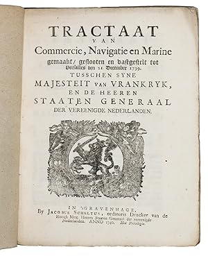
Tractaat van commercie, navigatie en marine gemaakt, geslooten en vastgestelt to Versailles den 21 December 1739. Tusschen Syne Majesteit van Vrankryk, en de Heeren Staaten Generaal der Vereenigde Nederlanden.The Hague, Jacobus Scheltus, 1740. 4to. With the woodcut printer's device of Scheltus and a woodcut initial.19th-century brown wrappers.
Librería: ASHER Rare Books, T Goy Houten, Holanda
Miembro de asociación: ILAB NVVA
Valoración del vendedor:
43 pp.First edition of the renewed treaty, originally concluded on 11 April 1713 in the framework of the Peace of Utrecht, simultaneously published in Paris, L Imprimerie Royale, 1740, while the French text was also printed in the same year by the same printer Scheltus (Knuttel, 17128).The important treaty is on free trade between the two countries and on common tariffs and imposts ( d établir un tarif commun ). After 25 years therefore, a revision had become necessary.The negotiators were Jean-Jacques Amelot de Chaillon (1689-1749) and the Dutch Embassador in Paris Abraham van Hoey (1684-1766).With the bookplate of the city library of Dordrecht on the paper wrapper (partly gone). Edges a little frayed, otherwise in good condition.l Knuttel, 17129; Roussel, Recueil hist., 14, pp. 447-483.
-
L'Ampliateur hollandois au correcteur francois.
Librería: Antiquariaat Wim de Goeij, Kalmthout, ANTW, Belgica
Miembro de asociación: ILAB
Valoración del vendedor:
S.l. ('s Gravenhage), s.e., s.d. ( 1648 )(see pp. 5 "l'an présent 1648" ) small, in-8°, 40 nn pp , modern boards. On the treaty of Münster (Westphalia). Refutation of French objections made against the Dutch Republic. Very rare, we found only trace of a manuscript copy (BnF Dép. des Manuscrits ''Français 20865, anicienne cote ''Gaigničres 27932'').
-
Traité de commerce, navigation & marine, fait, conclu & arręté a Versailles le 21 Decembre de l an 1739, entre sa Majesté Tres-Chretienne, & les Seigneurs Etats Generaux des Provinces Unies du Pais-Bas.The Hague, Jacobus Scheltus, 1740 4to. With the woodcut printer's device of Scheltus and a woodcut initial. 19th-century brown wrappers.
Librería: ASHER Rare Books, T Goy Houten, Holanda
Miembro de asociación: ILAB NVVA
Valoración del vendedor:
43 pp.First edition of the renewed treaty, originally concluded on 11 April 1713 in the framework of the Peace of Utrecht, simultaneously published in Paris, L Imprimerie Royale, 1740, while the Dutch text was printed in the same year by the same printer Scheltus (Knuttel, 17129).The important treaty is on free trade between the two countries and on common tariffs and imposts ( d établir un tarif commun ). After 25 years therefore, a revision had become necessary.The negotiators were Jean-Jacques Amelot de Chaillon (1689-1749) and the Dutch Embassador in Paris Abraham van Hoey (1684-1766).With the bookplate of the city library of Dordrecht on the paper wrapper (partly gone). Edges a little frayed, otherwise in good condition.l Knuttel, 17128; Roussel, Recueil hist., 14, pp. 447-483.
-

STUNNING LARGE SCALE MAP OF THE DUTCH REPUBLIC "A New and Exact Map of the United Provinces, or Netherlands &c
Librería: Inter-Antiquariaat Mefferdt & De Jonge, Amsterdam, Holanda
Miembro de asociación: ILAB NVVA
Valoración del vendedor:
Arte / Grabado / Póster
STUNNING LARGE SCALE MAP OF THE DUTCH REPUBLIC "A New and Exact Map of the United Provinces, or Netherlands &c.", coper engraving made by Herman Moll, for his "A New and Compleat Atlas" published in London by John Bowles in 1715. Coloured by a later (') hand. Size: 61,5 x 101,5cm. This grand map of the Netherlands exemplifies Moll's particular virtues as a mapmaker. It is drawn on a large scale and has a wealth of geographical details including all the principal towns and major roads. Atlas maps on this scale were a recent innovation, and Moll made scale, readability and what would now be called user-friendliness hallmarks of his style. There is an inset map of the Channel and the North Sea along with seven views of the major towns, including Amsterdam, Rotterdam, Middelburg, Utrecht, Groningen as well a plan of Arx Britannica ("This fortress was built by the Roman emperor Caligula, upon the German Ocean at the mouth of the river Rhine, the a famous port, but now quite choked up with sand. [Abraham] Ortelius says that the very foundation of it was seen in the year 1552 and was found to be square, it also was seen for 20 days altogether in the year 1562 and lastly in the year 1588when people went round it and discovered several rare pieces of antiquity and money etc. About 1200 paces from this fort stood the famous town of Katwijk, now a poor village inhabited by fishermen."), and a view of King William's palace Het Loo. In his disclaimer Moll writes: "This map is taken from actual surveys and the most correct maps that have been done of these provinces. I have been as exact as I could to give the true proportions of the towns in respect to one another, as also the meers [lakes], rivers, trekvaarts or artificial canals by which passengers travel from town to town, and the dykes on which they all depend." Herman Moll (1654-1732) came to London in about 1678 from Germany or Holland and worked as an engraver for Moses Pitt, among others. He clearly had a talent for making interesting friends and provided maps for Daniel Defoe's Robinson Crusoe and Jonathan Swift's Gulliver's Travels. He also knew explorer/buccaneer William Dampier and the chemist Robert Boyle. From 1689, he had his own London shop. Maps of a uniquely Moll character began to appear during Queen Anne's reign, and his individual style of mapmaking grew increasingly more distinct as his career progressed. Herman Moll, was one of the most significant and distinctive European cartographers of the late seventeenth and early eighteenth centuries. He enjoyed a lengthy and productive career that spanned almost six decades and yielded more than two dozen geographies, atlases, and histories, as well as myriad separate maps, charts and globes spanning the known world. Although generally not held in high regard for the originality or content of his cartography, he possessed a strong and tasteful design sense that, when combined with his engraving talents, led to the creation of unique and aesthetically pleasing maps, some of which must be considered graphic masterpieces. His work was much copied by other publishers and he enjoyed a high reputation. Moll and his maps flourished during the fascinating and dynamic era of the British Enlightenment and the early, heady days of empire. Prijs: Euro 975,-.
-
Traitté d alliance defensive, entre l Angleterre et les Estats Generaux, conclu le 3. Mars 1678.Cologne [recté: Amsterdam?], "Pierre Marteau", 1680. 4to. With the woodcut English royal arms on the title-page. 19th-century brown paper wrappers.
Librería: ASHER Rare Books, T Goy Houten, Holanda
Miembro de asociación: ILAB NVVA
Valoración del vendedor:
[8] pp.Extremely rare pamphlet with the text - in French - of the Anglo-Dutch defensive alliance of 3 March 1678. In May 1672, French forces had invaded the Dutch Republic and initially seemed to have achieved an overwhelming victory (the so-called "Rampjaar 1672"). England supported France in what became the Second Anglo-Dutch (maritime) war (1672-1674). By late July 1672, however, the Dutch position had stabilized thanks to the new Stadholder Willem III. Concern about French gains led to the August 1673 Treaty of the Hague between the Republic, Brandenburg-Prussia, the Emperor Leopold and King Charles II of Spain; in early 1674 England and the Dutch made peace in the Treaty of Westminster. In November 1677 Willem III married his cousin Mary, niece of King Charles II of England. In the meantime, peace talks had begun in 1676 in Nijmegen resulting in an Anglo-Dutch defensive alliance, concluded on the 3rd of March 1678, almost a half year before the treaty was signed in August. But English troops arrived in significant numbers only in late May, allowing King Louis XIV to improve his negotiating position by capturing Ghent on the same day the alliance was concluded, on 3 March.Untrimmed and with bolts unopened. In good condition.l Muller 7609*; STCN 160843154? (2 copies); not in Knuttel; VD17.
-
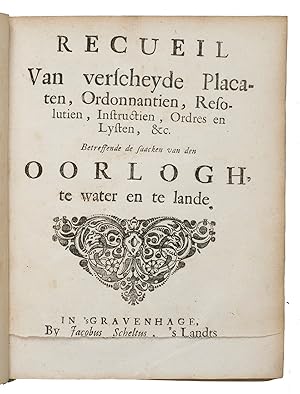
Recueil van verscheyde placaten, ordonantien, resolutien, instructien, ordres en lysten, etc. betreffende de saacken van den oorlogh, te water en te lande.The Hague, Jacob Scheltus, Aelbrecht Hendriksz, the heirs of Hillebrandt Jacobsz van Wouw, Paulus Scheltus, 1591-1716. 4to. With woodcut publishers' devices, title vignettes and decorated initials. Vellum over boards, manuscript title on spine, remains of green ties.
Librería: ASHER Rare Books, T Goy Houten, Holanda
Miembro de asociación: ILAB NVVA
Valoración del vendedor:
[8], [ca. 780] pp. containing 92 numbered items (2 folding).Very interesting collection of 92 numbered ordinances, resolutions, instructions, orders and lists concerning the army and naval forces of the Dutch Republic during its golden age, dating from 1591 to 1716. At least seven times over a period of nearly fifty years, the printers to the States General produced similar preliminaries to reissue and/or reprint a series of previously published official documents. The first - with documents 1-72 - by Jacob Scheltus in 1675. Expanded versions followed in 1688 and 1722, the latter by Paulus and Isaac Scheltus. Since Jacob is not otherwise recorded after 1712, the present edition (containing a document dated 1716) may have been printed by Paulus Scheltus under Jacob s name.The documents include ordinances on the military discipline, (no.1, 1705), "placaten" (publicly posted documents) on the engaging of soldiers and seamen, orders on armament, payment, instructions for admirals, officers, provost marshal, orders regarding transportation of military forces and goods, quartering, against looting, using bad language, insubordination and desertion (including punishments), forms of oaths, structures of various army units, on drill practices, military clothing, prisoners of war, etc.Binding slightly soiled, otherwise in good condition.l STCN (2 copies).
-
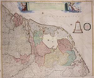
EERSTE POSTKAART VAN DE REPUBLIEK "Les Provinces Confedereés du Paďs-Bas avec les Terres adjacentes", kopergravure vervaardigd door Frederick de Wit, in dit geval uitgegeven door Covens en Mortier rond 1744
Librería: Inter-Antiquariaat Mefferdt & De Jonge, Amsterdam, Holanda
Miembro de asociación: ILAB NVVA
Valoración del vendedor:
Arte / Grabado / Póster
EERSTE POSTKAART VAN DE REPUBLIEK "Les Provinces Confedereés du Paďs-Bas avec les Terres adjacentes", kopergravure vervaardigd door Frederick de Wit, in dit geval uitgegeven door Covens en Mortier rond 1744. Later met de hand gekleurd. Afm. 101 x 118 cm. Frederick de Wit maakte rond 1660 een wandkaart van deZeventien Provinciën. Ten tijde van de verschijning van de kaart was het de meest aan de actualiteit van het wegennet ("les Grands Chemins") aangepaste kaart. Maar feitelijk was de kaart verouderd. De Nederlandse Republiek was door de Vrede van Münster(1648) een soevereine staat geworden en de kaart toont een gebied dat ook nog de Zuidelijke Nederlanden omhelst. De 9 koperen platen waarvan de kaart gedrukt was, kwamen na het overlijden van De Wit in het bezit van de Leidse uitgever en boekhandelaar Pieter van der Aa. Hij gebruikte de platen opnieuw, maar kortte ze in en liet de Zuidelijke Nederlanden wegvallen. Het zijn nu de Zeven Provinciën: "Les Provinces Confedereés du Paďs-Bas". Het titellint van de kaart en de cartouches werden ook vervangen en nieuwe aanduidingen voor de veiligheid van de scheepvaart (zoals waterdieptes en zandbanken) aangebracht. Daarnaast stempelde Van der Aa meer dan 225 kleine letters P in vierkante kadertjes op de kaart om weer te geven waar de op dat moment bestaande poststations ("Maisons des Poste") zich bevonden. Verder tekende hij fijne stippellijntjes in om de toenmalige postwegen aan te geven. Het maakte deze wandkaart tot de eerste postkaart van de Republiek. Na de Vrede van Münster kregen vele te paard strijdende soldaten of cavaleristen een nieuwe baan als postvervoerder of postiljon. Deze postiljons reisden door de steden, waar zij te herkennen waren aan hun hoorn, die werd gebruikt om aan te geven dat de postiljon in een stad aankwam of juist vertrok. Ook per schip en met de trekschuit werd veel post binnen de Nederlanden vervoerd. De postverbindingen tussen de steden waren immers vooral in het gewest Holland te vinden, waar voldoende vaarroutes voor handen waren. Het vervoer was echter traag, zodat postiljons soms hun werk overnamen. Daarnaast waren er koetsen, waarmee op vaste tijden tussen steden reizigers en goederen vervoerd werden. Het brievenverkeer kon hierop meeliften. Uiteindelijk kwamen in 1799 alle posterijen in handen van de Nederlandse staat. Literatuur: A.M. van der Heijden: "Oude kaarten der Nederlanden, 1548-1794" (1998),nr. 138/4 Prijs: Euro 3.250,-.
-
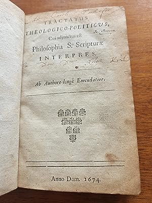
Tractatus Theologico-Politicus
Publicado por [Title page does not list the publisher nor the place of publication], 1674
Librería: Meir Turner, New York, NY, Estados Unidos de America
Valoración del vendedor:
Libro
Hardcover. Condición: Very Good. In Latin with occasional phrases in Hebrew. Old leather boards with new leather spine expertly restoring the whole. Original blank leaf preceding title page, [22 pages], 334, [4]; [16], 182, [19] pages, original blank leaf at end. [= original end paper, title leaf with blank verso, PRAEFATIO consisting of 9 pages, 3 pages of INDEX CAPITUM, TRACTATUS: pages 1 - 334, 2 blank leaves, PROLOGUS of 8 leaves with 8th leaf?s verso blank, PHILOSOPHIA SCRIPTURAE pages 1-182, EPILOGUS of 10 leaves with verso of 10th leaf blank, blank leaf.] The second work here, PHILOSOPHIA SCRIPTURAE, is by Spinoza'a friend and editor Ludovicus Mayer (Lodewijk Meijer), though Meijer's name does not appear and there is no separate title page for his work here. The title of this second work does appear in the title page of the Tractatus in the beginning of this book. Meijer's work here is a reprint of the 1666 Philosophia S. Scripturae, published by Rieuwertsz. It is a controversial work arguing for the philosophical interpretation of scripture. Since the Philosophia S. Scripturae Interpres often appears, without a title page and author's name, in this edition, it was once believed that this work is also by Spinoza. This third edition of Spinoza's work was published in Holland for distribution in England. The publisher's name and place do not appear, because Spinoza?s work was banned by the Hof in Holland in July 1674. 166 x 113 mm. Very old notations in ink on title page in 3 different hands: "Io: Brown"; "Liber Caroli Teullefor"; "Ese Dono Dmni Roberti Kirk" See BAR. Volume 60 page 503. & British Museum Catalogue. See, Printing and the Mind of Man 153 (1670 original edition); Bamberger T3.E (this edition). Baruch Spinoza was a Dutch philosopher of Portuguese Sephardic Jewish origin. He was one of the foremost exponents of 17th-century Rationalism and one of the early and seminal thinkers of the Enlightenment and modern biblical criticism including modern conceptions of the self and the universe. He is one of the most important philosophers of the early modern period. Inspired by the groundbreaking ideas of René Descartes, Spinoza became a leading philosophical figure of the Dutch Golden Age. He was raised in the Spanish-Portuguese-Jewish community in Amsterdam. He developed highly controversial ideas regarding the authenticity of the Hebrew Bible and the nature of the Divine. At age 23, the Jewish religious authorities issued a kherem (ban?) against him, to be shunned by Jewish society, including by his own family. Shortly after his death his books were added to the Catholic Church's Index of Forbidden Books. He was frequently called an "atheist" by contemporaries, although nowhere in his work does Spinoza argue against the existence of God. Spinoza lived an outwardly simple life as an optical lens grinder, collaborating on microscope and telescope lens designs with Constantijn and Christiaan Huygens. He turned down rewards and honors throughout his life, including prestigious teaching positions. Spinoza died at the age of 44 from a lung illness, perhaps tuberculosis or silicosis exacerbated by the inhalation of fine glass dust while grinding lenses.


![Imagen del vendedor de Traitté d alliance defensive, entre l Angleterre et les Estats Generaux, conclu le 3. Mars 1678.Cologne [recté: Amsterdam?], "Pierre Marteau", 1680. 4to. With the woodcut English royal arms on the title-page. 19th-century brown paper wrappers. a la venta por ASHER Rare Books](https://pictures.abebooks.com/inventory/md/md30950911004.jpg)