
Importe total (1 artículo artículos):
Destino del pedido:

COLLINS, CAPT GREENVILE (15 resultados)
Ir a los resultados principales
Tipo de artículo
- Todo tipo de artículos
- Libros (15)
- Revistas y publicaciones
- Cómics
- Partituras
- Arte, grabados y pósters
- Fotografías
- Mapas
-
Manuscritos y
coleccionismo de papel
Condición
- Todo
- Nuevos
- Antiguos o usados
Encuadernación
- Todo
- Tapa dura
- Tapa blanda
Más atributos
- Primera edición
- Firmado
- Sobrecubierta
- Con imágenes del vendedor
- Sin impresión bajo demanda
Ubicación del vendedor
Valoración de los vendedores
-
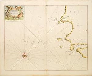
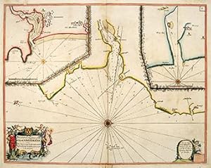
MILFORD HAVEN and the Islands adjacent
Publicado por Great Britain Coasting Pilot. 1760, 1760
Librería: Peter Harrington. ABA/ ILAB., London, Reino Unido
Miembro de asociación: ABA ILAB PBFA
Valoración del vendedor:

Chart of the Pembrokeshire coast near to Milford Haven with soundings rhumb lines. Title cartouche at top left surrounded by game birds. Captain Greenvile Collins was an outstanding naval officer who became 'Hydrographer to the King' before the Coasting Pilot was published. The Coasting Pilot was the result of the first systematic survey of British coastal waters. It took eight years to complete. The charts are notable for both their accuracy and their charm Tooley, Dictionary of Maps and Map Makers p.125; Moreland & Bannister, Antique Maps p.163 Copper engraving. Later colour. Expert repairs to margins and centrefold. Very good condition Size: 56 x 44 cm. (22 x 17˝ inches).
-
![Imagen del vendedor de [Coast of Wales]. a la venta por Peter Harrington. ABA/ ILAB.](https://pictures.abebooks.com/inventory/md/md2717926600.jpg)
[Coast of Wales].
Publicado por Great Britain Coasting Pilot. 1760, 1760
Librería: Peter Harrington. ABA/ ILAB., London, Reino Unido
Miembro de asociación: ABA ILAB PBFA
Valoración del vendedor:
Chart of the coast of Wales with north to the left, soundings and rhumb lines. Five silhouetees of ladnforms from the sea along top edge. Ornate dedicatory cartouche at lower left to 'Sr Cloudesley Shovell. Captain Greenvile Collins was an outstanding naval officer who became 'Hydrographer to the King' before the Coasting Pilot was published. The Coasting Pilot was the result of the first systematic survey of British coastal waters. It took eight years to complete. The charts are notable for both their accuracy and their charm Tooley, Dictionary of Maps and Map Makers p.125; Moreland & Bannister, Antique Maps p.163 Copper engraving. Later colour. Expert repairs to margins. Very good condition Size: 56 x 44 cm. (22 x 17˝ inches).
-
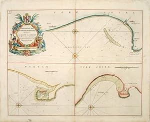
BURLINGTON BAY, SCARBROUGH AND HARTLEPOOL.
Publicado por London 1760, 1760
Librería: Peter Harrington. ABA/ ILAB., London, Reino Unido
Miembro de asociación: ABA ILAB PBFA
Valoración del vendedor:
Chart in three parts, with Burlington Bay, above, Hartlepool at lower left, and Scarborough at lower right. Each map shows north to the right, has sandbanks, soundings and rhumb lines. Decorated cartouche at top left.The Great Britain Coasting Pilot was the result of the first systematic survey of British coastal waters. It took eight years to complete, and was used by the Royal Navy for navigating British waters for many years. The charts are notable for both their accuracy and their charm.Captain Greenvile Collins was an outstanding naval officer who became 'Hydrographer to the King' before the Coasting Pilot was published. Tooley, Dictionary of Maps and Map Makers p.125; Moreland & Bannister, Antique Maps p.163 Copper engraving. Later colour. Expert repairs to margins, centrefold. Very good condition. Size: 56.5 x 44.5 cm.
-

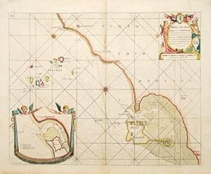
HOLYHEAD.
Publicado por Great Britain Coasting Pilot. 1760, 1760
Librería: Peter Harrington. ABA/ ILAB., London, Reino Unido
Miembro de asociación: ABA ILAB PBFA
Valoración del vendedor:
Sea Chart of Holyhead, North Wales, with rhumb lines and soundings. North to the left of map. Title in ornamental cartouche at lower left. Inset views of coastline as seen from various positions at sea ('Holyhead Nb.E 4 leagues'). Captain Greenvile Collins was an outstanding naval officer who became 'Hydrographer to the King' before the Coasting Pilot was published. The Coasting Pilot was the result of the first systematic survey of British coastal waters. It took eight years to complete. The charts are notable for both their accuracy and their charm Tooley, Dictionary of Maps and Map Makers p.125; Moreland & Bannister, Antique Maps p.163 Copper engraving. Expert repairs to margins and centrefold. Very good condition Size: 56.5 x 44 cm. (22 x 17˝ inches).
-
HOLY ISLAND Staples and Barwick.
Publicado por London 1760, 1760
Librería: Peter Harrington. ABA/ ILAB., London, Reino Unido
Miembro de asociación: ABA ILAB PBFA
Valoración del vendedor:
Sea chart of Northumberland coast from Sunderland to just south of Berwick. Soundings and rhumb lines, north to lower edge of map. Inset map of Berwick 'Barwick') at lower left. Decorated title cartouche at top right. Captain Greenvile Collins was an outstanding naval officer who became 'Hydrographer to the King' before the Coasting Pilot was published. The Coasting Pilot was the result of the first systematic survey of British coastal waters. It took eight years to complete. The charts are notable for both their accuracy and their charm Tooley, Dictionary of Maps and Map Makers p.125; Moreland & Bannister, Antique Maps p.163 Copper engraving. Expert repairs to margins and centrefold, tiny binding holes on centrefold Size: 56 x 44 cm.
-
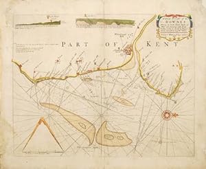
A Large Draught of the DOWNES showing the Sand Shoales Depths of Water and Anchorage with all the Leading markes to avoid the Dangers therein. Survey'd by Capt, Wm. Nunn
Publicado por London. 1760, 1760
Librería: Peter Harrington. ABA/ ILAB., London, Reino Unido
Miembro de asociación: ABA ILAB PBFA
Valoración del vendedor:
Attractive sea chart of the western coast of Kent from Dover Castle to North Foreland. Rhumb lines, sandbanks, soundings, and two coastal silhouettes around South Foreland on top edge of map. Title cartouche at top right and scale at lower left. The Great Britain Coasting Pilot was the result of the first systematic survey of British coastal waters. It took eight years to complete, and was used by the Royla Navy for navigating British waters for many years. The charts are notable for both their accuracy and their charm.Captain Greenvile Collins was an outstanding naval officer who became 'Hydrographer to the King' before the Coasting Pilot was published. Tooley, Dictionary of Maps and Map Makers p.125; Moreland & Bannister, Antique Maps p.163 Copper engraving. Later colour. Expert repairs to margins. Very good condition. Size: 54 x 42 cm.
-
The Sea Coast from Fissnesse to Montrose.
Publicado por Great Britain Coasting Pilot. 1760, 1760
Librería: Peter Harrington. ABA/ ILAB., London, Reino Unido
Miembro de asociación: ABA ILAB PBFA
Valoración del vendedor:
Sea chart of the coast from Crail to Aberdeen on Scotland's east coast, with inset maps of Aberdeen and Montrose harbours. Soundings and rhumb lines, ornamental cartouche at lower left with dedication to the magistrates of Aberdeen. Captain Greenvile Collins was an outstanding naval officer who became 'Hydrographer to the King' before the Coasting Pilot was published. The Coasting Pilot was the result of the first systematic survey of British coastal waters. It took eight years to complete. The charts are notable for both their accuracy and their charm Tooley, Dictionary of Maps and Map Makers p.125; Moreland & Bannister, Antique Maps p.163 Copper engraving. Expert repairs to margins and centrefold Size: 56 x 44 cm. (22 x 17˝ inches).
-
![Imagen del vendedor de [Moray Firth] a la venta por Peter Harrington. ABA/ ILAB.](https://pictures.abebooks.com/inventory/md/md2717928177.jpg)
[Moray Firth]
Publicado por Great Britain Coasting Pilot. 1760, 1760
Librería: Peter Harrington. ABA/ ILAB., London, Reino Unido
Miembro de asociación: ABA ILAB PBFA
Valoración del vendedor:
Chart of the Moray Firth in NE Scotland, with soundings and rhumblines. North to right of map.Dedicatory cartouche to Lord Viscount Torbat at top right. Captain Greenvile Collins was an outstanding naval officer who became 'Hydrographer to the King' before the Coasting Pilot was published. The Coasting Pilot was the result of the first systematic survey of British coastal waters. It took eight years to complete. The charts are notable for both their accuracy and their charm Tooley, Dictionary of Maps and Map Makers p.125; Moreland & Bannister, Antique Maps p.163 Copper engraving. Later colour. Expert repairs to margins and centrefold Size: 56 x 44 cm. (22 x 17˝ inches).
-
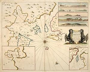
The Chief Harbours in the Islands of ORKNEY
Publicado por Great Britain Coasting Pilot. 1760, 1760
Librería: Peter Harrington. ABA/ ILAB., London, Reino Unido
Miembro de asociación: ABA ILAB PBFA
Valoración del vendedor:
Sea chart of the harbours of Orkney. The main map shows the sea inlets around Kirkwall, two inset maps show Deer Sound and Stromness. Five coastal silhouettes inset at top right, title cartouche flanked by black eagles at centre right. The Great Britain Coasting Pilot was the result of the first systematic survey of British coastal waters. It took eight years to complete, and was used by the Royal Navy for navigating British waters for many years. The charts are notable for both their accuracy and their charm. Captain Greenvile Collins was an outstanding naval officer who became 'Hydrographer to the King' before the Coasting Pilot was published. Tooled, Dictionary of Maps and Map Makers p.125; Moorland & Bannister, Antique Maps p.163 Copper engraving. Later colour. Expert repairs, mainly to upper margin. Very good condition. Size: 56 x 44 cm. (22 x 17˝ inches).
-
![Imagen del vendedor de [The Isle of Man and coast of North West England]. a la venta por Peter Harrington. ABA/ ILAB.](https://pictures.abebooks.com/inventory/md/md2717929171.jpg)
[The Isle of Man and coast of North West England].
Publicado por London 1760, 1760
Librería: Peter Harrington. ABA/ ILAB., London, Reino Unido
Miembro de asociación: ABA ILAB PBFA
Valoración del vendedor:
Chart of the coast of northwest England from the Mersey to the Solway Firth with adjacent coasts of Scotland and Wales, Isle of Man at upper centre. Compass point at centre shows north to the right of map. Soundings rhumb lines, ships at sea.Two inset coastal silhouettes at lower left. The Great Britain Coasting Pilot was the result of the first systematic survey of British coastal waters. It took eight years to complete, and was used by the Royal Navy for navigating British waters for many years. The charts are notable for both their accuracy and their charm.Captain Greenvile Collins was an outstanding naval officer who became 'Hydrographer to the King' before the Coasting Pilot was published. Tooley, Dictionary of Maps and Map Makers p.125; Moreland & Bannister, Antique Maps p.163 Copper engraving. Later colour. Expert repairs to margin, two wormholes on upper margin. Very good condition. Size: 56 x 44 cm.
-
![Imagen del vendedor de [East Coast of England]. a la venta por Peter Harrington. ABA/ ILAB.](https://pictures.abebooks.com/inventory/md/md2717925066.jpg)
[East Coast of England].
Publicado por London 1760, 1760
Librería: Peter Harrington. ABA/ ILAB., London, Reino Unido
Miembro de asociación: ABA ILAB PBFA
Valoración del vendedor:
Sea chart of east coast of England. The map is very busy with rhumblines and soundings, compass point with north to right, decorated dedicatory cartoushe at lower right to 'SR Ralph de la Valk, Vice Admiral of the Red.Captain Greenvile Collins was an outstanding naval officer who became 'Hydrographer to the King' before the Coasting Pilot was published. The Coasting Pilot was the result of the first systematic survey of British coastal waters. It took eight years to complete. The charts are notable for both their accuracy and their charm Tooley, Dictionary of Maps and Map Makers p.125; Moreland & Bannister, Antique Maps p.163 Copper engraving. Later colour. Expert repairs to margin and centrefold. Very good condition Size: 56 x 44 cm.
-
![Imagen del vendedor de [The Irish Sea]. a la venta por Peter Harrington. ABA/ ILAB.](https://pictures.abebooks.com/inventory/md/md2717925822.jpg)
[The Irish Sea].
Publicado por Great Britain Coasting Pilot. 1760, 1760
Librería: Peter Harrington. ABA/ ILAB., London, Reino Unido
Miembro de asociación: ABA ILAB PBFA
Valoración del vendedor:
Sea chart showing the coast line of England and Wales from Land's End to the Solway Firth, and the eastern coast of Ireland. Numerous soundings arounc coast, rhumblines, compass point at sea shows north to the right. Dedicatory cartouche to 'SR Richard Rooth' at right. Captain Greenvile Collins was an outstanding naval officer who became 'Hydrographer to the King' before the Coasting Pilot was published. The Coasting Pilot was the result of the first systematic survey of British coastal waters. It took eight years to complete, and was used by the British Navy for many years. The charts are notable for both their accuracy and their charm Tooley, Dictionary of Maps and Map Makers p.125; Moreland & Bannister, Antique Maps p.163 Copper engraving. Later colour. Expert repairs to margin and centrefold. Very good condition Size: 58.3 x 46 cm. (23 x 18 inches).
-
![Imagen del vendedor de [FIRTH OF FORTH]. a la venta por Peter Harrington. ABA/ ILAB.](https://pictures.abebooks.com/inventory/md/md2717927358.jpg)
[FIRTH OF FORTH].
Publicado por Great Britain Coasting Pilot. 1760, 1760
Librería: Peter Harrington. ABA/ ILAB., London, Reino Unido
Miembro de asociación: ABA ILAB PBFA
Valoración del vendedor:
Sea chart of the Firth of Forth, showing the coast from Dunbar to St, Andrews. Soundings, rhumblines. Inset map of coast from St. Abb's Head to Berwick. Dedicatory cartouche at top left, decorated with spears, bannersmermaids and seamonsters, with scale in English miles below. The Great Britain Coasting Pilot was the result of the first systematic survey of British coastal waters. It took eight years to complete, and was used by the Royla Navy for navigating British waters for many years. The charts are notable for both their accuracy and their charm.Captain Greenvile Collins was an outstanding naval officer who became 'Hydrographer to the King' before the Coasting Pilot was published. Tooley, Dictionary of Maps and Map Makers p.125; Moreland & Bannister, Antique Maps p.163 Copper engraving. Later colour. Expert repairs to margins. Very good condition Size: 56.5 x 45 cm. (22 x 17˝ inches).
-
![Imagen del vendedor de [ENGLISH CHANNEL]. a la venta por Peter Harrington. ABA/ ILAB.](https://pictures.abebooks.com/inventory/md/md2717924884.jpg)
[ENGLISH CHANNEL].
Publicado por London. c1760, 1760
Librería: Peter Harrington. ABA/ ILAB., London, Reino Unido
Miembro de asociación: ABA ILAB PBFA
Valoración del vendedor:
A detailed sea chart of the northern part of the English channel, from Kent to Norfolk, from Calais to Frisland, showing sandbanks, soundings, rhumb lines. There is a dedicatory cartouche at lower right on sea shell held aloft by sea nymphs. Captain Greenvile Collins was an outstanding naval officer who became 'Hydrographer to the King' before the Coasting Pilot was published. 'The Coasting Pilot' atlas was the result of the first systematic survey of British coastal waters. It took eight years to complete. The work proved to be extremely popular, and was reissued many times over a number of years. The charts are notable for both their accuracy and their charm. (Ref Tooley, Dictionary of Maps and Map Makers p.125; Moreland & Bannister, Antique Maps p.163). Tooley, Dictionary of Maps and Map Makers p.125; Moreland & Bannister, Antique Maps p.163 Size: 570 x 445 mm. Copper engraving. Later colour. Expert repairs to margins Very good condition.
-
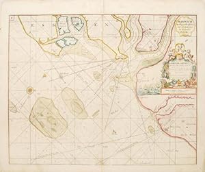
Harwich,Woodbridge and Handfordwater with the Sands from the Nazeland to Hosely Bay.
Publicado por London: 1760, 1760
Librería: Peter Harrington. ABA/ ILAB., London, Reino Unido
Miembro de asociación: ABA ILAB PBFA
Valoración del vendedor:
Attractive sea chart of Harwich and surrounding coastline, north to right of map, soundings, rhumb lines. Decorated dedicatory cartouche- to Samuel Pepys- with cherubs, fish and shells, and scale in English miles below, with a sketch of a sea battle to left of cartouche. Captain Greenvile Collins was an outstanding naval officer who became 'Hydrographer to the King' before the Coasting Pilot was published. The Coasting Pilot was the result of the first systematic survey of British coastal waters. It took eight years to complete. The charts are notable for both their accuracy and their charm. Published in the 'Great Britain Coasting Pilot'. Tooley, Dictionary of Maps and Map Makers p.125; Moreland & Bannister, Antique Maps p.163 Size: 565 x 440 mm. Copper engraving. Later colour. Expert repairs to margins, wormhole on top margin. Very good condition.