
Importe total (1 artículo artículos):
Destino del pedido:

BONNE R (37 resultados)
Ir a los resultados principales
Tipo de artículo
- Todo tipo de artículos
- Libros (26)
- Revistas y publicaciones
- Cómics
- Partituras
- Arte, grabados y pósters
- Fotografías
- Mapas (11)
-
Manuscritos y
coleccionismo de papel
Condición
Encuadernación
Más atributos
- Primera edición
- Firmado
- Sobrecubierta
- Con imágenes del vendedor (20)
- Sin impresión bajo demanda (28)
Gastos de envío gratis
Ubicación del vendedor
Valoración de los vendedores
-
Rfutation d'un ouvrage de M RizziZannoni intitul Dissertation sur diffrens points de gographie et d'un autre qui a pour titre claircissemens historiques sur un fait littraire
Publicado por Hachette Livre - BNF, 2018
ISBN 10: 2329065086ISBN 13: 9782329065083
Librería: PBShop.store US, Wood Dale, IL, Estados Unidos de America
Valoración del vendedor:

Libro Impresión bajo demanda
PAP. Condición: New. New Book. Shipped from UK. THIS BOOK IS PRINTED ON DEMAND. Established seller since 2000.
Más opciones de compra de otros vendedores en IberLibro
Nuevo desde EUR 24,67
-

Principes sur les mesures en longueur et en capacit, sur les poids et les monnoies dpendant du mouvement des astres principaux et de la grandeur de la terre, ouvrage
Publicado por Hachette Livre - BNF, 2017
ISBN 10: 2013032374ISBN 13: 9782013032377
Librería: PBShop.store US, Wood Dale, IL, Estados Unidos de America
Valoración del vendedor:
Libro Impresión bajo demanda
PAP. Condición: New. New Book. Shipped from UK. THIS BOOK IS PRINTED ON DEMAND. Established seller since 2000.
Más opciones de compra de otros vendedores en IberLibro
Nuevo desde EUR 25,82
-

Analyse du petit Neptune anglois ou de la carte marine contenant les ctes des Royaumes d'Angleterre, d'cosse et d'Irlande
Publicado por Hachette Livre - BNF, 2018
ISBN 10: 2329065078ISBN 13: 9782329065076
Librería: PBShop.store US, Wood Dale, IL, Estados Unidos de America
Valoración del vendedor:
Libro Impresión bajo demanda
PAP. Condición: New. New Book. Shipped from UK. THIS BOOK IS PRINTED ON DEMAND. Established seller since 2000.
Más opciones de compra de otros vendedores en IberLibro
Nuevo desde EUR 28,01
-

Tanja Geke liest Paddy Richardson, Komm, spiel mit mir. aus dem Engl. übers. von Eva Bonné. Aufnahme und Regie: Ludwig Karmann
Publicado por Köln : Lübbe Audio - [Burgwedel] : Tonpool-Medien-GmbH [Vertrieb], 2012
ISBN 10: 3785747543ISBN 13: 9783785747544
Libro
Condición: Neu. Bearb. Fassung. 4 CDs (298 Min.) ; 12 cm, in Behältnis 13 x 14 x 2 cm Sprache: Deutsch Gewicht in Gramm: 469 12,7 x 1,0 x 14,2 cm, 12,7 x 1,0 x 14,2 cm, audioCD.
-
Considrations sur l'emploi de la lumire et des ombres pour exprimer le relief du terrain dans les cartes topographiques
Publicado por Hachette Livre - BNF, 2017
ISBN 10: 2013032366ISBN 13: 9782013032360
Librería: PBShop.store US, Wood Dale, IL, Estados Unidos de America
Valoración del vendedor:
Libro Impresión bajo demanda
PAP. Condición: New. New Book. Shipped from UK. THIS BOOK IS PRINTED ON DEMAND. Established seller since 2000.
Más opciones de compra de otros vendedores en IberLibro
Nuevo desde EUR 30,17
-
Refutation d'un ouvrage de M. Rizzi-Zannoni intitule Dissertation sur differens points de geographie
Publicado por HACHETTE LIVRE-BNF 2018-02, 2018
ISBN 10: 2013096712ISBN 13: 9782013096713
Libro
PF. Condición: New.
-
![Imagen del vendedor de C.R. Bonne's Instructions on Yeast and Ferments 1885 [LeatherBound] a la venta por True World of Books](https://pictures.abebooks.com/inventory/md/md31617390146.jpg)
C.R. Bonne's Instructions on Yeast and Ferments 1885 [LeatherBound]
Ańo de publicación: 2023
Libro Impresión bajo demanda
LeatherBound. Condición: New. LeatherBound edition. Condition: New. Reprinted from edition. Leather Binding on Spine and Corners with Golden leaf printing on spine. Bound in genuine leather with Satin ribbon page markers and Spine with raised gilt bands. A perfect gift for your loved ones. NO changes have been made to the original text. This is NOT a retyped or an ocr'd reprint. Illustrations, Index, if any, are included in black and white. Each page is checked manually before printing. As this print on demand book is reprinted from a very old book, there could be some missing or flawed pages, but we always try to make the book as complete as possible. Fold-outs, if any, are not part of the book. If the original book was published in multiple volumes then this reprint is of only one volume, not the whole set. Sewing binding for longer life, where the book block is actually sewn (smythe sewn/section sewn) with thread before binding which results in a more durable type of binding. Pages: 63.
-

Biotechnologie 11/12 Kapital, Recht, Lizenzen
Publicado por BIOCOM AG, 2011
ISBN 10: 392838337XISBN 13: 9783928383370
Librería: Roland Antiquariat UG haftungsbeschränkt, Weinheim, Alemania
Valoración del vendedor:
Libro
152 Seiten Ungelesenes Buch. Sehr guter Zustand. Evtl. minimale Lagerspuren. 9783928383370 Sprache: Deutsch Gewicht in Gramm: 240 Softcover, Größe: 14.9 x 1.7 x 21 cm.
-

Alone Together
Publicado por Random House, 1986
ISBN 10: 0394558359ISBN 13: 9780394558356
Librería: Books Puddle, New York, NY, Estados Unidos de America
Valoración del vendedor:

Libro
Condición: New. 269 16 of lates.
Más opciones de compra de otros vendedores en IberLibro
Nuevo desde EUR 32,44
-

Kupferstich-Karte 'La Guyane Francoise, avec partie de la Guyane Hollandoise'. Par M. Bonne, Ingenieur-Hydrographe de la Marine.
Publicado por Um, 1800
Librería: Antiquariat Bücher und Mehr, Northeim, Alemania
Valoración del vendedor:
Uncoloriertes Blatt, ca. 37 x 26 cm, Mittelfalz, gering gebräunt. Ich versende innerhalb Deutschlands gegen Rechnung, Kreditkarten-/Paypalzahlungen bitte nur von ausländischen Bestellern. Französisch-Guayana, Guyana.
-

Hacia una Institución Educativa Efectiva. Parte I
Publicado por Editorial Académica Espańola, 2017
ISBN 10: 6202241535ISBN 13: 9786202241533
Libro
Condición: New.
-
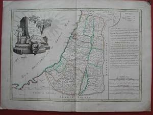
ISRAELE. Carte des douze tribus d'Israel. Carta geografica acquarellata all'epoca. Da R. Bonne, Parigi, 1762
Ańo de publicación: 1762
Librería: La Casa del Collezionista, Pistoia, PT, Italia
Valoración del vendedor:
ISRAELE. Carte des douze tribus d'Israel. Bella carta geografica acquarellata all'epoca raffig. il territorio occupato dalle dodici trib ebraiche. Splendido cartiglio figurato. Mm 440x310 pi marg. (complessiv. mm 510x375). Tratta dall'atlante di R. Bonne, Parigi 1762. Buona conservazione eccetto lacune restaurate sulle punte dei margini bianchi. (Rif.A4860-424/48).
-
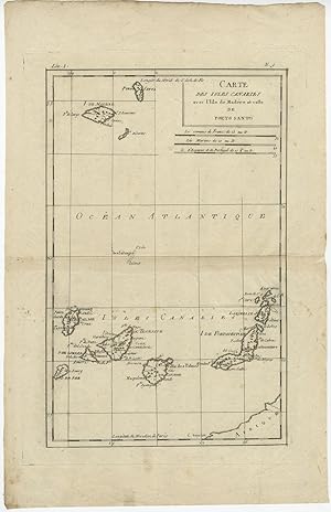
Antique Map of the Canary Islands, Madeira and Porto Santo by R. Bonne (c.1790)
Ańo de publicación: 1790
Librería: Bartele Gallery - The Netherlands, Langweer, FRL, Holanda
Miembro de asociación: ILAB NVVA
Valoración del vendedor:
Mapa
No Binding. Condición: Good. Antique map titled 'Carte des Isles Canaries avec l'Isle de Madere et celles de Porto Santo'. A map of the Canary Islands, Madeira and Porto Santo by R. Bonne (c.1790). General age-related toning and minor foxing. Overall size: 26 x 41 cm. Image size: 19.5 x 30.5 cm.
-
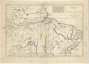
Antique Map of Brazil by Bonne (c.1780)
Ańo de publicación: 1780
Librería: Bartele Gallery - The Netherlands, Langweer, FRL, Holanda
Miembro de asociación: ILAB NVVA
Valoración del vendedor:
Mapa
No Binding. Condición: Good. Antique map titled 'Brésil et Pays des Amazones'. Original antique map of Brazil published by R. Bonne, c. 1780. General age-related toning, please study image carefully. Overall size: 39 x 28 cm. Image size: 36 x 24 cm. The collection of Bartele Gallery includes over 50,000 authentic antique maps, sea charts, prints and books. Our Abebooks store includes a selection of maps, prints and books for SALE prices. Please visit our other online sales channels to explore our complete collection of original antique maps and prints!.
-
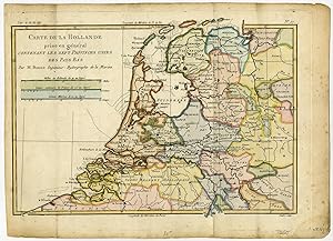
Antique Print-NETHERLANDS-SEVEN UNITED PROVINCES-Bonne-Andre-ca. 1780
Publicado por ca. 1780, 1780
Librería: Pictura Prints, Art & Books, Overasselt, Holanda
Miembro de asociación: ILAB NVVA
Valoración del vendedor:
Condición: Good. R. Bonne Ilustrador. 'Carte de la Hollande prise en general contenant les Sept Provinces Unies des Pays Bas.'Outline coloured engraving on hand laid (verge) paper. Sheet size: 36,7 x 26,7 cm. (14,4 x 10,5 inch). Image size: 32,5 x 22,6 cm. (12,8 x 8,9 inch).From an unidentified atlas by Bonne, ca. 1780Made by 'Andre' after 'R. Bonne'. Rigobert Bonne (1727-1795 ) was one of the most important cartographers of the late 18th century. In 1773 he succeeded Jacques Bellin as Royal Cartographer to France in the office of the Hydrographer at the Depot de la Marine. Working in his official capacity Bonne compiled some of the most detailed and accurate maps of the period.Condition: Good, given age. Original folds, as issued. General age-related toning and/or occasional minor defects from handling. Please study scan carefully.Keywords: NETHERLANDS-SEVEN UNITED PROVINCESRBOS-A1-30.
-
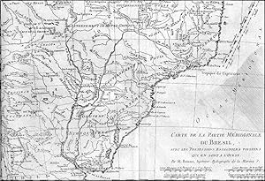
CARTE DE LA PARTIE MERIDIONALE DU BRESIL.'. Southern Brazil, Uruguay and Paraguay.
Publicado por Bonne ca. 1778, 1778
Mapa
21x32cm.
-
Carte du Perou ou se trouvent les Audiences de Quito, Lima et la Plata Grenzkolorierte Kupferstichkarte, Paris, 1783.
Librería: Antiquariat Kurt Lammek, Oldenburg, Alemania
Miembro de asociación: ILAB VDA
Valoración del vendedor:
43,7 x 31,5 cm. Gutes Exemplar. Zeigt Peru und Teile der umliegenden Länder. Contemp. outline colour, good condition.
-
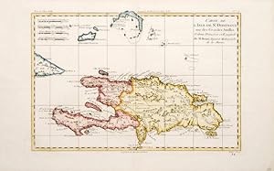
Carte de L'Isle de St. Dominique une des Grande Antilles.
Publicado por Paris. c1787, 1787
Librería: Peter Harrington. ABA/ ILAB., London, Reino Unido
Miembro de asociación: ABA ILAB PBFA
Valoración del vendedor:
A detailed and pleasant map of the French/Spanish Caribbean island of Hispaniola/Santa Domingo. Later the island became Haiti and Dominica respectively. Size: 25.5 x 41 mm. Copperplate engraving with later colour. Fine condition.
-
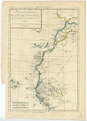
Antique Map of Western Africa by R. Bonne (c.1780)
Publicado por G. Raynal, 1780
Librería: Bartele Gallery - The Netherlands, Langweer, FRL, Holanda
Miembro de asociación: ILAB NVVA
Valoración del vendedor:
Mapa
No Binding. Condición: Very Good. Antique map titled 'Partie Occidentale de L'Ancien Continent'.This area corresponds to modern day Morocco, Western Sahara, Mauritania, and Algeria. Includes the Canary Islands, Madeira Island, and Cape Verde Islands. Originates from 'Atlas de Toutes les Parties Connues du Globe Terrestre, Dressé pour l'Histoire Philosophique et Politique des Établissemens et du Commerce des Européens dans les Deux Indes'. General age-related toning, please study image carefully. Overall size: 25.5 x 35 cm. Image size: 21.5 x 32 cm. The collection of Bartele Gallery includes over 50,000 authentic antique maps, sea charts, prints and books. Our Abebooks store includes a selection of maps, prints and books for SALE prices. Please visit our other online sales channels to explore our complete collection of original antique maps and prints!.
-

Antique Map of the Island of Cuba by R.Bonne (1780)
Publicado por G. Raynal, 1780
Librería: Bartele Gallery - The Netherlands, Langweer, FRL, Holanda
Miembro de asociación: ILAB NVVA
Valoración del vendedor:
Mapa
No Binding. Condición: Good. Antique map titled 'L'Isle de Cuba'. A fine example of Rigobert Bonne and Guilleme Raynal's 1780 map of Cuba. Shows towns, rivers, some topographical features, political boundaries and important ports and some offshore features. Includes the Bahamas and Florida Keys in lesser detail. Drawn by R. Bonne for G. Raynal's Atlas de Toutes les Parties Connues du Globe Terrestre, Dressé pour l'Histoire Philosophique et Politique des Établissemens et du Commerce des Européens dans les Deux Indes. Age-related toning, please study image carefully. Overall size: 40.5 x 26 cm. Image size: 32 x 22 cm.
-
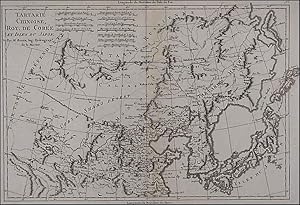
TARTARIE CHINOISE, ROY. DE CORÉE ET ISLES DU JAPON . China, Korea and Japan.
Publicado por Bonne ca. 1787, 1787
Mapa
24x36cm.
-

Antique Map of Papua New Guinea and Surroundings (Indonesia) by R. Bonne (1780)
Publicado por R. Bonne, 1780
Librería: Bartele Gallery - The Netherlands, Langweer, FRL, Holanda
Miembro de asociación: ILAB NVVA
Valoración del vendedor:
Mapa
No Binding. Condición: Fair. Antique map titled 'Carte des découvertes du Capite. Carteret dans la Nlle. Bretagne, avec une partie du passage du Capite (.)'. Detailed map of Papua New Guinea and the regions to the West, including New Ireland, Southern Mindanao, Joseph Freewill, Sable Banks and part of the Celebes. This map originates from 'Atlas de Toutes les Parties Connues du Globe Terrestre'. General age-related toning, please study image carefully. Overall size: 41.5 x 28 cm. Image size: 34.5 x 23.7 cm.
-
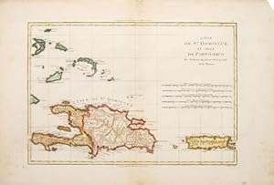
L'ISLE DE ST. DOMINGUE ET CELLE DE PORTO-RICO.
Publicado por Paris. c1787, 1787
Librería: Peter Harrington. ABA/ ILAB., London, Reino Unido
Miembro de asociación: ABA ILAB PBFA
Valoración del vendedor:
A map of the French/Spanish Caribbean island of what is today Haiti and Santa Domingo, together with that of neighbouring Porto-Rico. Size: 310 x 465 mm. Copperplate engraving with later hand colouring. Fair condition. Some foxing. Margins chipped.
-
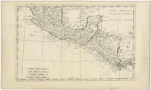
Antique Map of Mexico by R. Bonne (c.1780)
Publicado por R. Bonne, 1780
Librería: Bartele Gallery - The Netherlands, Langweer, FRL, Holanda
Miembro de asociación: ILAB NVVA
Valoración del vendedor:
Mapa
No Binding. Condición: Very Good. Antique map, titled: 'Partie Meridionale, de L'Ancien Mexique ou de la Nouvelle Espagne.' - Detailed map of Mexico, the Yucatan and Central America, prepared under the direction of Rigobert Bonne. Shows towns, rivers, mountains, lakes, etc. Detailed map of the region. General age-related toning, please study image carefully. Overall size: 39.5 x 23.5 cm. Image size: 31.5 x 21 cm.
-
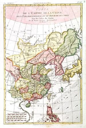
CARTE DE L'EMPIRE DE LA CHINE, DE LA TARTARIE CHINOISE, ET DU ROYAUME DE COREE: AVEC LES ISLES DU JAPON'. Map of China, Korea and Japan.
Publicado por Rigobert Bonne ca. 1778, 1778
Mapa
32x21cm. Full later colour. Excellent condition.
-
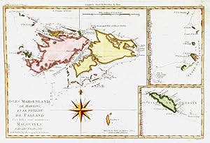
ISLES MAIDENLAND, DE HAWKINS, ET LE DETROIT DE FALKLAND. . Map of the Falkland Islands and inset maps of South Georgia and Sandwich Islands.
Publicado por Rigobert Bonne ca. 1774, 1774
Mapa
23x34cm. Full colour. Excellent condition.
-
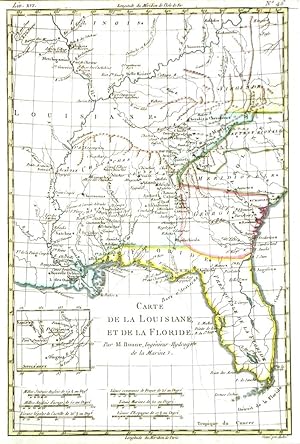
CARTE DE LA LOUISIANE, ET DE LA FLORIDE . Southeastern States between Florida, Mississippi and Ohio. Engraved by André for
Publicado por Rigobert Bonne ca. 1780, 1780
Mapa
No Binding. Condición: Very Good. 32x21cm. Recent outline colour. Excellent condition.
-
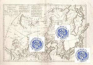
TARTARIE CHINOISE, ROY. DE COREE ET ISLES DU JAPON.
Librería: RARE ORIENTAL BOOK CO., ABAA, ILAB, Aptos, CA, Estados Unidos de America
Miembro de asociación: ABAA ILAB
Valoración del vendedor:
[Paris c1754-55]. Single sheet copper engraved map,very good clean copy, map size 40.5 x 28.5 cm., sheet size 40.7 x 29cm distance key to neighboring countries, a bit of old foxing, else very nicely executed, center folded. . . *** **** *** . . A MID-18TH CENTURY COPPER ENGRAVED MAP . . * This work covers the Tartarie Russienne to the North, Kurile islands to the East, Nanking & Kiusiu to the South, Tartarie Independante to the far West, along with the Gobi or Shamo Desert, Inner Mongolia, and the Korean peninsula with all of Japan shown, including Manchuria and the Steppe area. . * This fine example of early French cartography is suitable for framing & display. . * A wonderful detailed map, shows cities, rivers, mountains, costal areas, sea, bay, borders, travel routes &c. By and large, a very nice early work. . *** REFERENCE: R.T. Fell: EARLY MAPS OF S.E. ASIA, p.20, 55 for useful references. Fell suggests that this map is from "NEPTUNE FRANCOIS" atlas, or more likely the from "Neptune Oriental" atlas of 1754-55. . *.
-
TARTARIE CHINOISE, ROY. DE COREE ET ISLES DU JAPON.
Librería: RARE ORIENTAL BOOK CO., ABAA, ILAB, Aptos, CA, Estados Unidos de America
Miembro de asociación: ABAA ILAB
Valoración del vendedor:
[Paris c1754-55]. Single sheet copper engraved map,very good clean, no foxing, map size 40.5 x 28.5 cm., sheet size 45 x 29.5 cm., distance key to neighboring countries, bright copy very nicely executed, center folded. . . *** **** *** . . A MID-18TH CENTURY COPPER ENGRAVED MAP . . * This work covers the Tartarie Russienne to the North, Kurile islands to the East, Nanking & Kiusiu to the South, Tartarie Independante to the far West, along with the Gobi or Shamo Desert, Inner Mongolia, and the Korean peninsula with all of Japan shown, including Manchuria and the Steppe area. . * This fine example of early French cartography is suitable for framing & display. . * A wonderful detailed map, shows cities, rivers, mountains, costal areas, sea, bay, borders, travel routes &c. By and large, a very nice early work. . *** REFERENCE: R.T. Fell: EARLY MAPS OF S.E. ASIA, p.20, 55 for useful references. Fell suggests that this map is from "NEPTUNE FRANCOIS" atlas, or more likely the from "Neptune Oriental" atlas of 1754-55. . *.
-
Idea de la esfera, ó Principios de geografía astronómica. Obra traducida del francés, mejorada con algunas notas, y arreglada al meridiano de Madrid por Isidoro de Antillon. 3Ş ed.
Publicado por Leon Amarita, Madrid, 1829
Librería: LIBRERIA ANTICUARIA STUDIO, Barcelona, Espańa
Miembro de asociación: AILA ILAB
Valoración del vendedor:
Astronomía. Astronomy. 8ş, 1 lám., 72 p. Pergamino romana, letras pintadas lomo. [Ref. C9N123]. Interesante y bien impreso estudio sobre el movimiento de los astros, con una lámina representando la esfera, sus círculos y posiciones. Al final, tabla de las declinaciones del sol para un ańo medio entre dos bisiestos. (Palau 32821).
