Importe total (1 artículo artículos):
Destino del pedido:

BEERS, S N AND D G (14 resultados)
Ir a los resultados principales
Tipo de artículo
- Todo tipo de artículos
- Libros (14)
- Revistas y publicaciones
- Cómics
- Partituras
- Arte, grabados y pósters
- Fotografías
- Mapas
-
Manuscritos y
coleccionismo de papel
Condición
- Todo
- Nuevos
- Antiguos o usados
Encuadernación
Más atributos
- Primera edición (3)
- Firmado
- Sobrecubierta
- Con imágenes del vendedor (10)
- Sin impresión bajo demanda
Ubicación del vendedor
Valoración de los vendedores
-
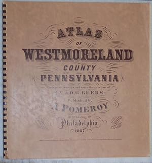
Atlas of Westmoreland County Pennsylvania 1867
Publicado por McClain Printing Company, Parsons, West Virginia, 1981
Librería: Newhouse Books, Washington Court House, OH, Estados Unidos de America
Valoración del vendedor:

Libro
Coil. Condición: Like New. One thousand copies printed Spring 1981. This is copy number 863 "Price: $25.00, postpaid" (1981) Dimensions: 15 X 15 1/2 in. 71 pages plus index.
-

New Topographical Atlas of Saratoga Co. (County), New York
Ańo de publicación: 1969
Librería: Muddy Turtle Books, Fernandina Beach, FL, Estados Unidos de America
Valoración del vendedor:
Facsimile Edition. This is an exact copy of the original atlas published by Stone and Stewart in 1866. Pink stain on small part of front cover, One tear at top of cover and first page (title page). Otherwise all the maps, illustrations and county information are in fine con [PC-BOT] We provide PROTECTIVE packaging. Photos of our books are always available upon request. SELLING USED AND RARE BOOKS ON ABE SINCE 1997. GERMAN & FRENCH CUSTOMERS PLEASE CONTACT US USING THE LINK ABOVE.
-
New topographical atlas of Saratoga County, New York. From the actual surveys by S.N. and D.G. Beers and assistants
Publicado por Rexford, Howard Becker, [circa, 1960
Librería: Hammer Mountain Book Halls, ABAA, Schenectady, NY, Estados Unidos de America
Miembro de asociación: ABAA ILAB
Valoración del vendedor:
Softcover. Front cover sun-faded at bottom edge, with several small spots; corners slightly bumped, slightly affecting pages; 1-inch split at bottom of taped binding; otherwise very good condition. An uncredited reprint issued circa 1960 by Howard Becker of Rexford, New York, and bound in his characteristic blue stiff covers. ]. 77p. Quarto.
-
![Imagen del vendedor de Yale Verse [1898-1908] a la venta por Yesterday's Muse, ABAA, ILAB, IOBA](https://pictures.abebooks.com/inventory/md/md31762900917.jpg)
Yale Verse [1898-1908]
Publicado por Yale Publishing Association, 1909
Librería: Yesterday's Muse, ABAA, ILAB, IOBA, Webster, NY, Estados Unidos de America
Miembro de asociación: ABAA ILAB IOBA
Valoración del vendedor:
Original o primera edición
Hard Cover. Condición: Good. No Jacket. First Edition. First edition. Boards lightly soiled with a couple light spots on front. 1909 Hard Cover. xii, 191 pp. Blue cloth, gilt titles. An interesting collection of first appearances: this volume represents the first book appearance of Sinclair Lewis (his contributions Behind the Arras, Exit Homo, Father Kileen, Odysseus at Ogygia, Puck, to Queen Mab, Saint Hubert, and When Viziers Speak are credited in the contents to H.S. Lewis because his real name first name was Harry), and the first appearances in print of Leonard Bacon and William Rose Benet. It was also the first published work of Robert Moses, then editor of the Yale Courant, who went on to become an extremely influential urban planner with a focus on public works. He is the subject of Robert Caro's Pulitzer Prize winning biography The Power Broker. This is the third volume collecting verse by Yale students (the others were released in 1889 and 1899).
-
Topographical Atlas of Schoharie Co. New York
Publicado por Martin Wehle, Churchville, NY, 1974
Librería: Dennis Holzman Antiques, Cohoes, NY, Estados Unidos de America
Valoración del vendedor:
Hardcover. Condición: Very Good. Estado de la sobrecubierta: No Dust Jacket. Reprint Edition. Size: 15 3/4" x 13 1/2". Text body is clean, and free from previous owner annotation, underlining and highlighting. Gilt-stamped beige cloth over boards, includes 63 maps. This atlas is number 131 of an edition of 300 and is signed by the publisher, Martin Wehle. Covers rubbed, a few scratches, clean interior. Quantity Available: 1. Shipped Weight: 4 lbs 0 oz. Category: Geography & Maps; Pictures of this item not already displayed here available upon request. Inventory No: 015654.
-
New Topographical Atlas of Schoharie County, New York, from Actual Surveys by S. N. & D. G. Beers and Assistants
Publicado por Martin Wehle, Churchville, NY, 1974
Librería: Saucony Book Shop, Kutztown, PA, Estados Unidos de America
Valoración del vendedor:
Cloth. Condición: Very Good. Estado de la sobrecubierta: Not Issued. Facsimile Reprint Edition. Dark blue cloth, lettered in gold foil. Facsimile reprint of original 1866 edition, offset printing by B & E Printers, binding by Rochester Book Bindery. Modest shelf wear, a few light surface marks to cloth, light rubbing to back cover. Two approx. 1/2" closed tears through cloth and underboard along bottom rear edge near joint, with some fraying to cloth at heel of spine. Light foxing to endsheets and main title, text block edges. Firm binding, otherwise clean interior. Scarce. Includes towns of Blenheim, Broome, Carlisle, Cobleskill, Conesville, Esperance, Fulton, Gilboa, Jefferson, Middleburgh, Richmondville, Schoharie, Seward, Sharon, Summit, Wright, etc. Size: Elephant Folio - over 15" - 23" tall. Book.
-
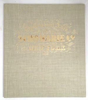
New Topographical Atlas of Genesee and Wyoming Counties [County], New York. From Actual Surveys by S.N. & D.G. Beers and Assistants. (Number 3 of a Series)
Publicado por Gates-Chili News, Incorporated / Rochester Book Bindery, 1971
Librería: Yesterday's Muse, ABAA, ILAB, IOBA, Webster, NY, Estados Unidos de America
Miembro de asociación: ABAA ILAB IOBA
Valoración del vendedor:
Libro
Large Hardcover. Condición: Very Good. No Jacket. Limited Edition. Limited edition, #143 of 300 copies. Endpapers foxed. 1971 Large Hardcover. Dozens of maps of towns and villages in Genesee and Wyoming County, New York, with three pages of engraved illustrations, and a statistical table.
-
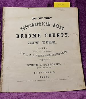
NEW TOPOGRAPHICAL ATLAS OF BROOME COUNTY NEW YORK From Actual Surveys
Publicado por Stone & Stewart, Publishers, 1866
Librería: THE BOOK VAULT, Binghamton, NY, Estados Unidos de America
Valoración del vendedor:
Libro Original o primera edición
Hardcover. Condición: Poor. No Jacket. 1st Edition. 15.625" X 14" ORIGINAL BOARDS MISSING. 2.5" tear fore-edge title page. Soil, especially last page: POOR. Very nice hand-colored maps, some of which fold out. 61pp. [CC030] [VERY RARE].
-
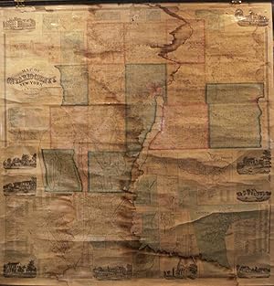
Map of Ontario County, New York
Publicado por Philadelphia, Philadelphia, 1859
Librería: High Ridge Books, Inc. - ABAA, South Deerfield, MA, Estados Unidos de America
Miembro de asociación: ABAA ESA ILAB SNEAB
Valoración del vendedor:
Fair condition, general wear overall, vertical crack from bottom at center, small chips, with some loss, from the towns of Manchester and Hopewell and two other small chips near the top. Water stain at bottom left corner. Lacks bottom rod. Wall map with 9 inset views of buildings and 28 inset plans of towns and villages. This county in the Finger Lakes region includes the Towns of Geneva and Canandaigua. Land owners identified on both the large map and the inset plans. Published by A. R. Z. Dawson. Phillips p. 640.
-
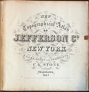
New Topographical Atlas of Jefferson Co., New York
Publicado por New York, New York, 1864
Librería: High Ridge Books, Inc. - ABAA, South Deerfield, MA, Estados Unidos de America
Miembro de asociación: ABAA ESA ILAB SNEAB
Valoración del vendedor:
Modern 1/4 leather with buckram. Internally fine, but this atlas is lacking the county map, which is listed on the contents leaf as the last map in the atlas. An otherwise excellent copy of one of the earliest American county atlases, the first by the Beers family who would become noted for this cartographic form. Ristow, p. 404, specifically mentions this atlas as the first for Daniel and Silas Beers. [84] p., 37 fully colored maps, one illustration. LeGear L2452.
-
New topographical atlas of St. Lawrence County, N.Y. : from actual surveys
Publicado por Philadelphia : Stone & Stewart, 1865
Librería: Sequitur Books, Boonsboro, MD, Estados Unidos de America
Miembro de asociación: IOBA
Valoración del vendedor:
Libro Original o primera edición
Hardcover. Condición: Fair. First Edition. Square folio, 39 x 41 cm. 92 pages : chiefly hand-colored lithographic maps. Collated, complete, 41 maps. Bound in publisher's marbled paste-paper boards over cloth spine. Lacking spine, boards detached. Edgewear to cover. Spotting, marginal dampstaining. This is an early county atlas made in the second year of the Beers family county atlas production. Engraved by Jas. McGuigan. This is an oversized or heavy book, which requires additional postage for international delivery outside the US.
-
NEW TOPOGRAPHICAL ATLAS OF ST. LAWRENCE CO., NEW YORK
Publicado por Stone & Stewart, Philadelphia, PA, 1865
Librería: Riverow Bookshop, Owego, NY, Estados Unidos de America
Miembro de asociación: ABAA ILAB
Valoración del vendedor:
Cloth/Boards. Condición: G/No Dustjacket. Black & White Illustrations Ilustrador. Philadelphia, PA: Stone & Stewart. G/No Dustjacket. 1865. . Cloth/Boards. pasted in plate on flyleaf . Folio, 92 pp., rubbed, bumped, cloth spine splitting, frayed, hinges broken, bookplate, page foxing & toning, corners chipped, stains .
-
New Topographical Atlas of Jefferson Co., New York: From Actual Surveys
Publicado por C. K. Stone, Philadelphia, PA, 1864
Librería: Dogwood Books, Rome, GA, Estados Unidos de America
Valoración del vendedor:

Libro
Hardcover. Condición: Very Good. No Jacket. The volume measures 16 1/2 x 16 1/2 inches. Includes 37 fully colored maps and one illustration The cover shows some edgewear with fading and rubbing. The binding is sound. The endpage and title page show edgewear with age toning. Maps are in excellent condition.
-
Map of Ontario County, New York
Publicado por Philadelphia, Philadelphia, 1859
Librería: High Ridge Books, Inc. - ABAA, South Deerfield, MA, Estados Unidos de America
Miembro de asociación: ABAA ESA ILAB SNEAB
Valoración del vendedor:
Generally good to very good condition, with a water stain down the center of the map, chipping at the top with loss to inset plan of Flint Creek. With 9 inset views of buildings and 28 inset plans of towns and villages. This county in the Finger Lakes region includes the Towns of Geneva and Canandaigua. Land owners identified on both the large map and the inset plans. Published by A. R. Z. Dawson. Phillips p. 640.

![Imagen del vendedor de New Topographical Atlas of Genesee and Wyoming Counties [County], New York. From Actual Surveys by S.N. & D.G. Beers and Assistants. (Number 3 of a Series) a la venta por Yesterday's Muse, ABAA, ILAB, IOBA](https://pictures.abebooks.com/inventory/md/md31760766926.jpg)