Descripción
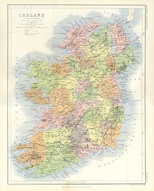
A HIGH RESOLUTION DOWNLOAD IS ALSO AVAILABLE, PLEASE EMAIL FOR INFO. 1861 HISTORICAL RELIEF MAP SHOWING TERRAIN, TOPOGRAPHY AND ENVIRONS WITH RAILWAYS , CANALS Approximate Image Size :12 1/2 x 9 1/2 inches Approximate Page Size: 13 1/4 x 10 3/4 inches DESCRIPTION: Ireland (Irish: Éire) is the third-largest island in Europe. It lies in the Atlantic Ocean and it is composed of the Republic of Ireland, which covers five sixths of the island (south, east, west and north-west), and Northern Ireland; part of the United Kingdom, which covers the northeastern sixth of the island.A ring of coastal mountains surrounds low central plains. The highest peak is Carrauntuohill (Irish: Corrán Tuathail), which is 1041 m (3414 feet). The island is bisected by the River Shannon, at 259 km (161 mi) the longest river in Ireland or Britain. The island's lush vegetation, a product of its mild climate and frequent but soft rainfall, earns it the sobriquet "Emerald Isle". The island's area is 84,079 km (32,477 mile ). Ireland is divided into four provinces: Connacht, Leinster, Munster and Ulster. These were further divided into 32 counties for administrative purposes. Six of the Ulster counties remain under British sovereignty as Northern Ireland following Ireland's partition in 1922 (the remaining 26 forming present-day Republic of Ireland); since the UK's 1974 reshuffle these county boundaries no longer exist in Northern Ireland for administrative purposes, although Fermanagh District Council is almost identical to the county. In the Republic, the county boundaries are still adhered to for local government, albeit with Tipperary and Dublin subdivided (some cities also have their own administrative regions). For election constituencies, some counties are merged or divided, but constitutionally the boundaries have to be observed. Across Ireland, the 32 counties are still used in sports and in some other cultural areas and retain a strong sense of local identity. Ireland's least arable land lies in the south-western and western counties. These areas are largely spectacularly mountainous and rocky, with beautiful green vistas. PROVENANCE PUBLISHED DATE 1861, EDINBURGH, LONDON PUBLISHER WILLIAM BLACKWOOD AND SONS ENGRAVERS W & A.K. JOHNSTON CONDITION The map is one large sheet with a fold across the center with binders tape on reverse side to keep the map sturdy and intact. Folded Colour Map. Blank on reverse side.Suitable ageing. The image is clean, clear and sharp with beautiful detail. As scanned. This beautiful rare item would look great matted and framed. An art supply store can provide you with a selection of frames for old art treasures. NOTE THE FOLLOWING BEFORE YOU PURCHASE: This is a GENUINE ANTIQUE PRINT. It is NOT a modern reproduction, ie. a laser scan, photocopy etc. This print was published on the date mentioned, or circa of the date mentioned at the top of the page. The term "print" is referred to an image on a piece of paper. The print I have for sale, like many antique prints, originate from an antique book publication. The publication may not always be known. If you have any questions, emails are welcome. N° de ref. del artículo 5984
Contactar al vendedor
Denunciar este artículo
![]()
