Descripción
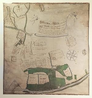
COLLIER, William. A True Plan of the Manor of Purly Malins in the Parish of Purly in the County of Berks. the Estate of Philip Powys Esq.r. NB. The Total of this Plan, is Two Hundred and Eleven Acres, which is Explained more at large in a book made to this Plan. Survey.d April the 25th Anno. Dom. 1732. By William Collier. Single sheet of vellum (25 x 23 inches). Fine original manuscript estate map in black and red ink and colour wash, of "Purly Malins", ie the ancient manor of Purley Parva, or Little Purley, one of the three manors of Purley centred on what is now Sulham Home Farm and Purley Hall. A detailed and attractive map oriented to the southwest, with the Thames running through the lower edge, showing a number of small holdings and their owners, the title within a floating banner upper centre, held aloft by two putti, and decorated with a compass rose lower right (some waterstaining and a bit browned). Philip Powys may have commissioned this map in 1732 as part of an attempt to reclaim an ancestral inheritance, the plea of his son Philip Lybbe-Powys was heard in 1759. The estate is named in the title as "Purly Malins" in reference to an early owner of the estate near Reading in Berkshire, England, Henry 'Malyns', who died about 1324, and was probably an ancestor of Powys. The manor remained in Malyn hands until 1424. In the early 18th-century the manor was owned by the Hydes, who were Roman Catholics and owned property and land in the parishes of Whitchurch, Purley, Pangbourne and Sulham, which were seized by the Crown because Francis Hyde refused to convert to the Church of England. Charles I gave a lease of the estate to William Smith in about 1628. Two years later Francis Hyde died having regained the manor and was succeeded by his son and heir Richard who died before 1665, when his son Francis was summoned to appear at Ashmole's visitation of the county. Francis Hyde died about 1688 and was succeeded by his son and grandson, both named Francis. The last Francis Hyde and his younger brother John sold the Hyde Hall estate in 1720 to Francis Hawes of Purley. Hawes was implicated in the affairs of the South Sea Company, his cousin Francis Hawes having been one of its promoters, and in 1722 the manor was put up for sale by the creditors of the company. It was bought by Charles Hall, but this appears to have been a creditors' settlement, as the Hawes remained in possession till 1753, when the property was in Chancery. It was heavily mortgaged and was finally bought from the creditors of the Hawes family by the Rev. Henry Wilder in 1773. William Collier (ca. 1687-1758), the creator of this map, may have been the Collier who was solicitor to Treasury and surveyor of coasts between 1710 and 1714 and possibly solicitor to Viscount Perceval in the 1730s. Both his skills in surveying and law would have been useful in the creation of this map. N° de ref. del artículo 72map426
Contactar al vendedor
Denunciar este artículo
![]()


