Descripción
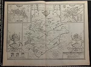
Single sheet (15 x 20 inches) Full margins showing the plate mark (slight browning to edge, light foxing, offsetting, ink spot centre crease) An elegant map of Rutlandshire; taken from the famous Theatre of the Empire of Great Britaine by English cartographer John Speed. Engraved by Jodocus Hondius in 1610, this county map is the best of its kind. It is highly sought after for it level of accuracy, detail, and craftsmanship. There are no finer county maps on the market. The county is introduced to us in a title cartouche, embellished with cranes, lobsters, and the county shield. Rutland is depicted as a landlocked county in the East Midlands of England; bounded to the west and north by Leicestershire, to the northeast by Lincolnshire and the southeast by Northamptonshire. It is the smallest historic county in England. The land shows few towns, and is rather left to the imagination for it's handsome forests, parks, and hills. The town plans of Oukham and Stanford mirror one another on opposing ends of the map. The town of Oukham is shown as a simple market town. Only the great hall of the Norman castle in Oukham is still standing, and is surrounded by steep earthworks marking the inner bailey. The hall dates from c. 1180-90. "It is the earliest hall of any English castle surviving so completely, and it is doubly interesting in that it belonged not to a castle strictly speaking, but rather to a fortified manor house." (Pevsner) The shield of Oukham decorates the upper corner. The symbol of the horseshoe on the shield is significant. Traditionally, members of royalty and peers of the realm who visited or passed through the town had to pay a forfeit in the form of a horseshoe. The town of Stanfort is represented as more bustling, with abbeys, small castles, and churches. Both of these plans were mapped by John Speed, as indicated by the 'Scale of Pases'. The final detail touches by Hondius includes a selection of coat of arms belonging to local ruling Earls and Dukes; an elaborate compass rose; cherubim; and the arms of the royal King. The county maps found in the Theatre of the Empire of Great Britaine were the first consistent attempt to show territorial divisions, but it was mainly Speed's town plans that were the major innovation and probably his greatest contribution to British cartography. Together, they formed the first printed collection of town plans of the British Isles and, for at least 50 of the 73 included in the Theatre, it was the first time these towns had been mapped. While being the first English atlas of the British Isles, Speed's Atlas was also one of the first attempts to accurately survey Ireland and to incorporate a comprehensive list of their town plans into the maps. The 1676 edition of Speed's atlas never came with original color. The examples of this map of Rutlandshire should always be uncolored and never colored. Born in Cheshire, John Speed developed his interest in maps in the 1580s, after moving to London to pursue his passions outside of tailoring. He there joined the Society of Antiquaries, where his enthusiasm for cartography won him the attention of William Camden, Robert Cotton, and Sir Fulke Greville. By working with these figures, Speed was able to do a large amount of research for his own work. In 1596, Greville bequeathed Speed with an unlimited allowance to research, and then later write, the Historie of Great Britaine. It was during this project which Speed had the encouragement to add a cartographic supplement to the work - what we today know as his most famous atlas. After being first published in 1611-1612, the 'Theatre of Great Britain' dominated the seventeenth-century English map market, going through many reprints and editions. Thanks to the Atlas' success, Speed earned the title of England's most well-known Stuart period cartographer and his work became the blueprint for folio atlases until the mid-18th century. Historically, Speed is also noted for placing England into the mainst. N° de ref. del artículo 72NZ40
Contactar al vendedor
Denunciar este artículo
![]()


