Descripción
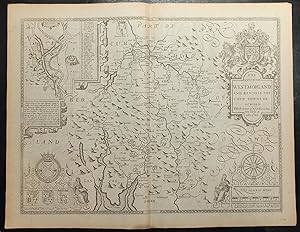
Single sheet (15 x 20 inches) Full margins showing the plate mark (slight browning to edge). This superb county map of Westmorland delights the eyes with its elegance and detail. It is a stunning part of John Speed's famous Theatre of the Empire of Great Britaine. The plate was engraved in Amsterdam by the great Dutch mapmaker Jodocus Hondius and the map exhibit the highest level of craftsmanship and artistic embellishment, reflecting the pervasive and appealing Mannerist style of the period, with strapwork cartouches, heraldic crests, and figures. The accuracy and detail of Speed's county maps is what makes them so highly desirable. The title cartouche presents itself nobly with the coat of arms of King Charles II. This smaller county of Britain stretches its borders with Cumberland, Yorkshire, and Lancashire. The town plan of Kendale is characterized on the left portion of the map. Kendale's homes, fortresses, and halls are met with a quaint pastoral background. A letter guide marks the significant roads and buildings of the town. A small framed story describes Malcolm King of Scots' rampage of the Westmorland country side and his marriage to Margaret of Saxony shortly before the successful unification efforts of King James. The Earls showcased below also include the arms of John de Foix, the 1st Earl of Kendal The shield of Ralph Neville, the 1st Earl of Westmorland, is singled out and highlighted, for his role as ally to the ruling Kings of England during his lifetime. The county maps found in the Theatre of the Empire of Great Britaine were the first consistent attempt to show territorial divisions, but it was mainly Speed's town plans that were the major innovation and probably his greatest contribution to British cartography. Together, they formed the first printed collection of town plans of the British Isles and, for at least 50 of the 73 included in the Theatre, it was the first time these towns had been mapped. While being the first English atlas of the British Isles, Speed's Atlas was also one of the first attempts to accurately survey Ireland and to incorporate a comprehensive list of their town plans into the maps. The 1676 edition of Speed's atlas never came with original color. The examples of this map of Westmorland should always be left uncolored and never colored. Born in Cheshire, John Speed developed his interest in maps in the 1580s, after moving to London to pursue his passions outside of tailoring. He there joined the Society of Antiquaries, where his enthusiasm for cartography won him the attention of William Camden, Robert Cotton, and Sir Fulke Greville. By working with these figures, Speed was able to do a large amount of research for his own work. In 1596, Greville bequeathed Speed with an unlimited allowance to research, and then later write, the Historie of Great Britaine. It was during this project which Speed had the encouragement to add a cartographic supplement to the work - what we today know as his most famous atlas. After being first published in 1611-1612, the 'Theatre of Great Britain' dominated the seventeenth-century English map market, going through many reprints and editions. Thanks to the Atlas' success, Speed earned the title of England's most well-known Stuart period cartographer and his work became the blueprint for folio atlases until the mid-18th century. Historically, Speed is also noted for placing England into the mainstream of map publishing, which had been dominated by the Dutch since the late sixteenth century. This map of Westmorland is an excellent part of the Theatre of the Empire of Great Britaine, and would be an outstanding addition to all map collections. For more information on this map, or a warm welcome to see other maps and books of our collection at 72nd Street NYC, please contact Natalie Zadrozna. N° de ref. del artículo 72NZ16
Contactar al vendedor
Denunciar este artículo
![]()


