Descripción
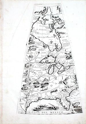
Single sheet, float-mounted and framed (19 x 13 4/8 inches, full margins showing the plate-mark; framed size: 28 4/8 x 22 4/8 inches). A fine engraved showing North America from Hudson Bay to the Gulf of Mexico which is decorated with a vignette of whalers pursuing narwhals, the landmass also contains some intriguing scenes of cannibalism, hunting, and alligators eating people whole. First published in 1688, this is the issue reprinted for Coronelli's celebrated "Isolario descrittione geografico-historia". As Royal Cartographer to King Louis XIV in the 1680s, mapmaker Vincenzo Coronelli gained special access to the most current records, and as Shirley reports "Coronelli seems to have sought to omit nothing that might be of interest to geographers, navigators and explorers. There are an unusual number of legends, all explanatory and informative, but which never crowd the space available. This globe gore represents the most advanced state of 17th-century knowledge regarding the geography of the Great Lakes and eastern portion of what is now the United States of America. As Royal Cartographer to King Louis XIV in the 1680s, mapmaker Vincenzo Coronelli gained special access to the most current records on American geography sent in from the colonies, and he relied heavily on manuscripts from the discoveries of the explorer Louis Joliet and of Jean-Baptiste-Louis Franquelin, official cartographer of maps relating to New France. Though this map was published roughly ten years after Coronelli's return to Venice, its sophisticated geographical information reflects the invaluable knowledge he had acquired in Paris. Following La Salle's 1681 to 1687 journey to its mouth, the Mississippi River is marked, and French aspirations can clearly be seen in the title Canada spread across nearly all the lands east of the Mississippi. Coronelli, probably best known for his spectacular pair of 15-foot globes of 1683, created for Louis XIV, and now on display in the Bibliotheque Nationale de France in Paris, was both cleric and encyclopedist, with a particular interest in geography and cartography. He joined the Franciscan Order in Venice in 1665 and six years later entered the convent of Santa Maria Gloriosa dei Frari, which was to become his professional workshop. He was sole author or contributor to over one hundred and forty titles and produced several hundred maps, either printed separately or as parts of atlases. Coronelli published his groundbreaking cartographic work in a number of notable publications, including the "Atlante Veneto" (1691-1692), the "Corso Geografico Universale" (1692 & 1695) and the "Isolario" (1696-1697). Most of his globe gores were obviously meant to be assembled into spherical form and sold as complete globes, though a very few examples, including this map, were kept aside to be published in sheet form in Coronelli's exceptionally rare "Libro dei Globi", and from his celebrated "Isolario." as here. After he completed his service for Louis XIV, Coronelli returned to Venice in 1684 and founded the "Accademia Cosmografica degli Argonauti," a geographical society with membership drawn from the aristocracy and church hierarchy, and a year later he was appointed Cosmographer to the Republic of Venice. With a secure financial base provided by the society, Coronelli could ensure that his maps would be widely dispersed across Europe. At the end of the seventeenth century, he was perhaps the most famous map publisher in Europe and received constant requests from his contemporaries for information that would enable them to bring their atlases up to date. Shortly after his death, however, his name and work were quickly forgotten, and he remained in obscurity for several centuries. The lasting influence of his work is undeniable, however, and modern appreciation has more than compensated for the earlier lack of recognition. N° de ref. del artículo 100150D
Contactar al vendedor
Denunciar este artículo
![]()
