Descripción
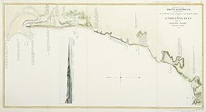
Rare and important map of the South Australian coast, extending from present day North Haven to Rapid Bay, dated 26th January, 1838 by Colonel William Light. Light had arrived off Kangaroo Island on 17 August 1836 and found the settlement established in July 1836 by the South Australian Company. The settlers had found the area to have poor soil quality which made it unsuitable for farming. Light as Surveyor-General of South Australia, was instructed to scout and survey various sites in preparation for the capital. The surveyed sites of; Nepean Bay, Kangaroo Island, Encounter Bay and Port Lincoln, were rejected due to a lack of fresh water supply and poor soil quality. On 7 September the Light in the Rapid anchored at a bay on the eastern side of St. Vincent's Gulf and which Light named Rapid Bay. He wrote in his diary at Yankylilly Bay; 'I never saw a more beautiful little Valley than this.' He continued north and soon sighted from the top of the mast a river entering a bay (Holdfast Bay) but did not examine it. Further north he found the coast to be swampy and covered with mangroves and thought a port for the capital would not be found on this coast. He returned to Holdfast Bay on 3 October and erected a flagstaff on the highest sand dune and used it as a bearing marker in relation to Mt. Lofty. On the 5th October he notes, "Having much to do in observing several bearings from the ship, for the purpose of constructing my 'hasty chart' of this side of the gulf." He proceeded to examined the bay and surrounding country travelling upriver by boat towards Mount Lofty, Light's 'joy was great' when he eventually found two fathoms of fresh water in a creek. He returned to search the coast for the entrance to 'Jones Harbour' (Port Adelaide) that Captain Barker had previously reported in 1831 as a good anchorage, without success. Light again returned to Rapid Bay and was joined by the Cygnet which he sent on 5 November to Holdfast Bay under deputy surveyor George Kingston with the advanced survey party before proceeding to Port Lincoln to assess it's suitability for the capital. He decided against Rapid Bay after surveying the Adelaide plains. He announced that the site of the new capital would be Adelaide on 29 December 1836 and drew up a plan for the town. The choice was controversial, particularly with the then Governor of the colony, Sir John Hindmarsh, who wanted the town to be placed on the coast. The Colonisation Commission had set Light an impossible task, He was expected to select the best site for the capital from 1,500 miles of coast line, survey the town, divide 150 square miles of country blocks, as well as select sites for secondary towns, all within two months of his arrival there. References: Collections: National Library Australia: Bib ID 6193561 State Library South Australia: rbr 402768 Image Size: 575mm x 303mm (22.6" x 12"). Paper Size: 635mm x 325mm (25" x 12.8"). Condition: In good condition, with folds as issued. Technique: Hand coloured lithograph. N° de ref. del artículo SARCC 009 SA
Contactar al vendedor
Denunciar este artículo
![]()

