Descripción
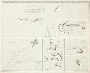
The preferred French issue of this important chart which is made up of a number of insets. The top half of the map is devoted to King George's Sound. The other insets include Dusky Sound J. Edwards Pall Mall and G. Robinson Paternoster Row, May 1st 1798 Vancouvers account was translated in Paris, in 1799, "Voyage De D'couvertes, A : Océan Pacifique du Nord, et autour Du Monde Dans lequel la côte nord-ouest de l Amérique a été soigneusement reconnue et exactement releve: . Exécuté En 1790, 1791, 1792, 1793, 1794 Et 1795 Par Le Capitaine George Vancouver. Traduit De L'Anglais, Tooley, 1278. Important pre-colonisation map of the Western Australian coast. George Vancouver (1791-1795) was appointed to undertake a hydrographic survey of the northwest coast of America and had also been given permission to examine that extent of coast of the south-west side of New Holland, which in the present age appears a real blot in geography. He planned to fall in with the S.W. Cape of New Holland, and should I find the shores capable of being navigated without much hazard to range its coast and determine whether it and Van Diemens Land are joined, which from all information at present extant appears somewhat doubtful. He left Falmouth in 1791 with the ships Discovery and Chatham, sailing southward to the Cape of Good Hope, traversing the Indian Ocean and making landfall at Cape Leeuwin on the southwest coast of Australia on 26 September 1791 where he claimed the coast for Great Britain. Two days later, he discovered one very excellent port which he named King George III Sound (present day Albany). He then examined a further four hundred and eighty kilometres of coastline but unfortunately had to abandon his examination of the western coast of Van Diemens Land due to strong easterly winds which forced him to travel south below Tasmania, thereby narrowly missing the opportunity to discover Bass Strait. From the French edition of Vancouvers Voyage de decouvertes a locean Pacifique du Nord, et autour du monde. This is the preferred edition of this map, printed on heavier paper and with more detail. Image Size: 745mm x 590mm (29.3" x 23.2"). Condition: In good condition, centre fold as issued. Technique: Original copper engraving. N° de ref. del artículo VANC AM WA 1799
Contactar al vendedor
Denunciar este artículo
![]()
