Descripción
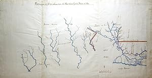
Sheet size: 21 4/8 x 41 2/8 inches. Ink and watercolour wash on paper. A FINE ORIGINAL MANUSCRIPT MAP showing portions of the provinces of Louisiana, West Florida and Texas and their respective boundaries during a time of challenge and attempted definition. As reflected in the map and related documents, the issue of international borders became acute beginning in 1803 in the context of the formal Spanish retrocession of Louisiana to France, the French sale of Louisiana to the United States, and a near military clash between American and Spanish forces in an area highlighted by the map, the northeastern corner of Texas. Following the wave of Spanish engineer-cartographers of the 1760s through the 1780s, with their rich, exuberant water colours and detail, Spanish mapmakers became more sparing and also less visible in their authorship, as evidenced by this one map. No signature or author identification appears. Yet, like so many other maps from the sixteenth through the nineteenth centuries, this one provides an excellent example of the importance of such documents as symbols of authority and possession in a part of the world (North America) where nation-states and empires competed with one another for control of territory, people, and resources. Maps provided significant visual complements to written documents when arguing ownership or claims for ill-defined borders. The focus and colouring of the map highlight two borders: the first, on the righthand side is the straight line of the thirty-first parallel or line of latitude beginning at the Mississippi River and running due east to the edge of the map above Lake Pontchartrain and New Orleans. The second highlighted border is the ninety-degree corner following what writers have identified as an Arroyo Hondo (not shown on the map) separating Los Adais (Los Adaes) in the province of Texas from Natchitoches in Louisiana. The line then runs south from the thirty-first parallel following the Mississippi River to the mouth of the Bayou Manchac (Iberville River), and then east to Lake Maurepas along that lake's north shore to its connection with Lake Pontchartrain, and finally along that lake's north, a line agreed upon in the treaty between Britain and France at the end of the Seven Years' War in 1763. The territory encompassed is prominently identified as "Territorio del Dominio de S.M. pertenence a la Florida" (Territory of the Dominion of His Majesty belonging to Florida"). This focus reveals local Spanish officials and the mapmaker's attempt to provide by way of a vivid illustration their ongoing effort to clarify and establish borders in a region where Spain, France, and Great Britain had competed with one another for over a hundred years. After achieving independence from Britain in 1783, the United States entered the game. When it purchased Louisiana from France in 1803, it began aggressively to claim as part of its acquisition lands the Spanish continued to regard as theirs. Diplomatic resolution of the issue between those two countries did not occur until 1819 by means of the Adams-Onis, or Transcontinental, Treaty, and its ratification in 1821. A more complete catalogue description written by Charles Weeks is available on request. N° de ref. del artículo 72lib286
Contactar al vendedor
Denunciar este artículo
![]()
