Descripción
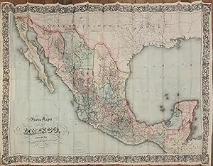
4 sheets joined, (35 ¾ x 50 ¾ inches). Fine folding lithographed map with original hand color in full (some separation at corners of folds, some darkening from glue where sheets are joined). Original publisher's brown cloth gilt (extremities a bit rubbed). Provenance: From the important cartographical library of Warren Heckrotte, his sale, Rare Cartography, Exploration and Voyages, Part II, December 3, 2015, Lot 118. Later issue, first published in 1866 with "Nuevo Mapa del Imperio de Mexico" on the cover. Large-scale, detailed and quite rare folding map of Mexico, in Spanish, at a time of increasing U.S. investment, with railroads, both completed and projected, shown, with indication by color whether narrow or wide gauge, as well as roads, settlements, state boundaries, drainage, etc. with prime meridian at Mexico City. Includes Borderlands and Texas, running east from San Diego to Mississippi. This map was published in the midst of great railroad expansion in the region: the Southern Transcontinental Railroad was constructed between 1879 and 1881, and the Southern Pacific Railroad's "Sunset Route" was built from California to New Orleans by way of Yuma, Tucson, El Paso, and San Antonio. Farther north, predecessors of the Santa Fe Railroad were completed across New Mexico and Arizona by 1881 and 1882. This map seems to be based on Colton's map of the Empire of Mexico of 1866. Not in Phillips. Orozco y Berra 618 (1871 printing). N° de ref. del artículo 72MMS382
Contactar al vendedor
Denunciar este artículo
![]()
