Descripción
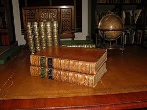
2 volumes. Folio (16 x 10 2/8 inches). Title-pages printed in red and black, privilege leaf facing title-page in volume one. 15 exceptionally fine engraved folding maps, 7 full-page engraved maps, and 39 engraved plates of portraits, town views, cultural scenes and natural history. Contemporary tan calf elaborately decorated in gilt (rebacked in the 19th-century preserving the original spines, endpapers renewed in the 19th-century). THE FIRST SEPARATE MAP OF AUSTRALIA IN ENGLISH A bright and attractive copy of the second and best edition, "revised, with large additions, and continued down to the present time; including particular accounts of the manufactures and commerce of each country", first published in 1705. Some of the recent additions include accounts of the voyages of Christopher Middleton, Woodes Rogers (including the rescue of Selkirk), Jacob Roggeveen, and George Shelvocke, and probably the first printed account of Bering's second expedition. One section of volume two is devoted to attempts to find the Northwest Passage. Most significantly this edition includes important cartographical additions by Emanuel Bowen (died 1767), who worked with Thomas Kitchin: two world maps in volume one, show all of northwest North America and the entire area below the Antarctic Circle as "Parts Undiscovered"; Abel Tasman's discoveries are depicted on the folding map of "New Holland" "A Complete Map of the Southern Continent Surveyed by Capt. Abel Tasman & Depicted by Order of the East India Company in Holland in the Stadt House at Amsterdam", and as such is the first separate depiction of Australia in English. Maps which portray discoveries in the Americas include: "A New & Correct Chart of All the Known World", showing a portion of the northwest coastline of Australia and one small section of New Zealand, in this map the Colorado River is named "North R"; "A New and Accurate Map of the World Drawn from the Best Authorities.Describing the Course of Each of the Following Circum-navigators.Magellan, Drake, and Anson", on which the Colorado River is correctly named; "A New and Accurate Map of America. Exhibiting the Course of the Trade Winds Both in the Atlantic & Pacific Oceans", on which California is correctly shown as a peninsula and the American northwest is devoid of detail and designated "Parts Undiscovered"; "A New & Accurate Chart of the Western or Atlantic Ocean."; "A New and Accurate Chart of the West Indies, with the Adjacent Coasts of North and South America" on which the routes of Spanish galleons are traced; "A New Map of Georgia with Part of Carolina, Florida and Louisiana", which is a rare, large-format, large-scale map showing the region from Charleston to the Mississippi River, it is among the early maps to focus on Georgia, and was used in a 1981 Supreme Court battle over the location of the boundary between Georgia and South Carolina at the mouth of the Savannah River, it was presented as evidence of Georgia's claim that the boundary lies on the northern bank of the river; "A Correct Draught of the North Pole and of All the Countries Hitherto Discovered, Intercepted Between the Pole and the Parallel of 50 Degrees", showing the routes of significant Arctic expeditions to the east as well as to the west, with tracks of the numerous attempts to find the Northeast and Northwest Passages to the economic riches of Asia, much of Greenland and the western part of the North America remain "undiscovered," and decorative cartouches conveniently obscure the unknown Northwest coast. Hill 775; Sabin 30483; "Mapping our World: Terra Incognita to Australia", National Library of Australia, page 143. Catalogued by Kate Hunter. N° de ref. del artículo 72lib539
Contactar al vendedor
Denunciar este artículo
Detalles bibliográficos
Título: Navigantium atque Itinerantium Bibliotheca. ...
Editorial: London: T. Woodward, A. Ward, S. Birt,. 1744-1748.
Encuadernación: Encuadernación de tapa dura
![]()


