Descripción
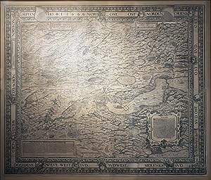
MURER, Jos (1530-1580). Eigentliche Verzeichnuss der Stätten, Graffschafften, und Herrschafften, welche in der Statt Zürich Gebiet und Landschafft gehörig seind. Zürich : Bodmerscher Buchladen, 1670 16 sheets, joined (42 x 49 4/8 inches), float-mounted and framed. A magnificent woodcut pictorial wall-map of the Canton/State of Zurich, centred on Zurich, the map itself in six sheets, surrounded by broad border depicting wind-heads/skulls and giving the compass directions, the title and the original date of the map appear within a banner lower right. Showing the area around Zurich, the actual Canton marked by a dotted line, in great detail, with Lake Geneva occupying a large portion of the lower right, mountains, other lakes, towns and villages all shown pictorially. The title upper left, the dedication to Otto von Friezinger upper right, a history of the state of Zurich lower left and the ancient history of the area within a superb mannerist strapwork cartouche lower right (margins torn with minor loss in one or two places) Third edition, according to Arthur Durst, first printed in 1566 (no extant copies known), then in 1568 by the nephew of the celebrated printer Christoffel Froschauer, Christoffel Froschauer the younger. Subsequent editions were published in 1700, 1759, 1765, and in the 19th and 20th-centuries. The early editions are very rare: OCLC locates on 3 examples of this 1670 edition in libraries, and those are all in Switzerland. In 1566, when the original woodblocks for this map were created, the state of Zurich was a member of the Old Swiss Confederacy, which from 1499 had created a loose republic with greater collective autonomy within the Holy Roman Empire. The Canton, or state, of Zurich, contained the eponymous capital of Switzerland, the financial capital of Europe. For the previous thirty years the city had been the centre of the Protestant Reformation in German-speaking Switzerland, led by Ulrich Zwingli who had been preaching there since 1518, and whose reformed bible had been published there in 1529. By the time this edition of Murer's map was published in 1670, Zurich had become a fortified city against the Thirty Years War, but had maintained its neutrality with other member states of the Confederacy. Murer also created a detailed birds-eye view of the city of Zurich: "Der uralten wytbekannten Statt Zurych gestalt und gelaegenhait", published by Froschauer in 1576. As with this map of the entire Canton of Zurich, the map is very detailed, showing the medieval city virtually unchanged, down to the last house. it was later used as the basis for Braun and Hogenberg's birds-eye view of Zurich, published in their "Civitates orbis terrarium". Durst "Das alteste bekannte Exemplar der Holzschnittkarte des Zurcher Gebiets 1566 von Jos Muere und deren spatere Auflagen" 1975; Mathis, Zürich, 137, Nr. 6B. N° de ref. del artículo 72map416
Contactar al vendedor
Denunciar este artículo
![]()
