Descripción
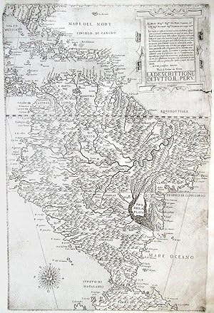
Al Molto Mag.co Sig.or Gio. Pietro Contarini del Cl.mo Sig.or Bernardo Sig.or et patron mio sempre oss.mo Le molte et infinite cortesie usatime da. V.M. mi astrin-gono a pensare continuarmente, con qual uia possa dimostrarle un picciol segno della infinita obligatione, che ho uerso V.M. per la qual cosa, hauendo io questi di addietro intagliata l'America, con un gran parte della Florida, da tutti com-munanmente detto il Mondo nuouo, ho uo;uto farla andar fuori soto l'honorato nome di V.M. Di V.M. prontissimo Seruitore Paulo di Forland da Veron. LA. DESCRITTIONE. DI. TVTTO. IL. PERV. Single sheet, float-mounted and framed (21 x 15 inches; 20 1/8 x 14 4/8 inches to the neat line, full margins showing the plate mark). EXCEPTIONALLY FINE AND DETAILED ENGRAVED MAP OF SOUTH AMERICA, showing the whole of Florida in the northwest, some of the Gulf of Mexico, some of Central America, Bermuda and the West Indies, and all the way south to Terra del Fuego, the ocean decorated with a compass rose lower left, the title and dedication within a fine mannerist strapwork cartouche upper right THE FIRST LARGE-SCALE DELINEATION OF SOUTH AMERICA TO APPEAR IN PRINT The two leading cartographic figures in the Lafreri school were undoubtedly Giacomo Gastaldi (ca.1500-1566), arguably the greatest cartographer of the period, and Paolo Forlani (fl. 1560-1571), the leading engraver/mapmaker of the day, with a great artistic sensibility, both of whom worked in Venice. Forlani, was responsible for some of the most beautiful and visually appealing maps of his time, the most important and impressive of which is undoubtedly his "La descrittione di tutto il Perv", the first large-scale delineation of South America to appear in print and the only Lafreri school map of South America. A landmark in the mapping of South America, this is the largest and most detailed delineation of that continent published to date, the map also includes most of the West Indies and the southern extremity of Florida, a large Tierra del Fuego, and all the Caribbean islands. Unfortunately, with the rise of Antwerp as a major cartographical centre, this map did not have the long-term influence it deserves, although it is a standard feature of Italian atlases of the period. For the geographical information, Forlani drew in large part on the world map published in 1561 by his eminent colleague Giacomo Gastaldi, the most accomplished cartographer of sixteenth-century Italy. Following in the footsteps of his great colleague Giacomo Gastaldi, Paolo Forlani was a Venetian engraver and publisher of many significant maps and charts in the period of the Renaissance. It was in Italy, and particularly in Venice, that the map trade, which was to influence profoundly the course of cartographic history, was most highly developed during the first half of the 16th century. Venice was the most active port in the world, and successful trading expeditions necessitated accurate maps. Venetian ships made regular trading voyages to the Levant and into the Black Sea, to the ports of Spain and Portugal, and along the coasts of Western Europe. In the 15th century the city had already become a clearing-house for geographical information, and the development of cartography in the city was further impelled by the accomplishment of Venetian printers and engravers. Forlani was perhaps the most prolific producer of maps in the mid-16th century, and largely responsible for diffusing advanced geographical information to other parts of Europe. He was much-sought after as an engraver and mapmaker, particularly as he was adept at the difficult art of engraving lettering. Consequently, he was employed by four of the leading publishers of the period to prepare maps for them: Giovanni Francesco Camocio, Ferrando Bertelli and Bolognini Zaltieri from Venice, as well as Claudio Duchetti from Rome. This map is a rare example of Forlani's original work, and it had a seminal influence on subsequent cartography of the western hemis. N° de ref. del artículo 72map297
Contactar al vendedor
Denunciar este artículo
![]()
